General Recap
A strong storm affected the eastern half of Colorado this week and brought heavy snow to many areas along the front range. In fact, several areas around Boulder and West of Fort Collins and Loveland set records in regards to how much snowfall they received. Closer to home, the Palmer Divide saw heavy snow, high accumulations and strong winds.
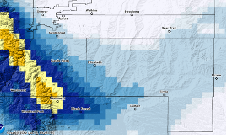
Snow Forecast Recap
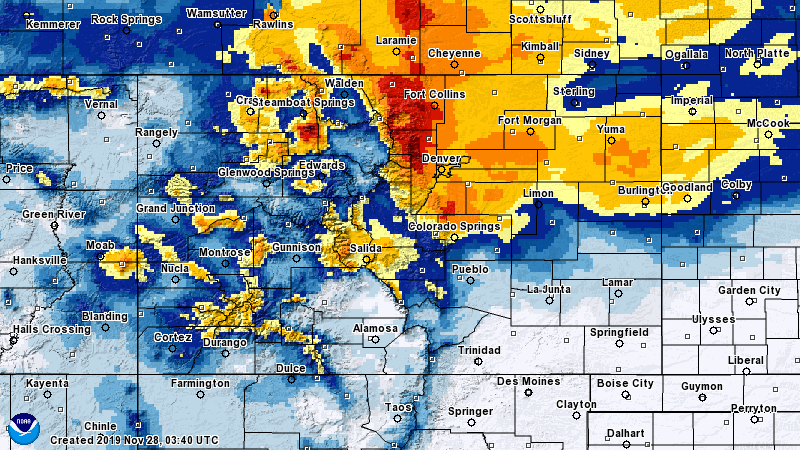
48 hour interpolated snowfall accumulations for Colorado
Here’s the point-by-point breakdown in regards to our forecast with additional snowfall amounts listed below:
Legend: [Verified Within Forecast Range] [Close to Forecast Range (+/- 1-2 inches of accumulation] [Minor Forecast Bust (+/- 2-4 inches of accumulation] [Major Forecast Bust (+/-4 inches or more/less accumulation]
| City | 24-48 hour Forecast Range | Within 12-24 hour Forecast Range | Actual Amount |
|---|---|---|---|
| Castle Rock | 5-10 | 7-14 | 12.1 |
| Parker | 6-12 | 7-14 | 14.0 |
| Highlands Ranch | 5-10 | 7-14 | 13.8 |
| Elbert | 5-10 | 7-14 | 11.9 |
| Elizabeth | 5-10 | 6-12 | 14.2 |
| Kiowa | 4-8 | 4-8 | 10.2 |
| Centennial | 6-12 | 7-14 | 13.5 |
| Denver | 7-14 | 7-14 | 9.5 |
| Larkspur | 5-10 | 6-12 | 14.8 |
| Monument | 5-10 | 5-10 | 17.0 |
| Black Forest | 2-5 | 4-8 | 15.0 |
| Littleton | 6-12 | 6-12 | 13.0 |
**Kiowa, Larkspur and Black Forest had no reports; took the closest stations available for numbers. They are not included in the forecast evaluation below.
- Overall Forecast Range Recap:
- 6 out of 9 verified
- 0 out of 9 were very close to forecast range
- 2 were minor busts
- 1 were major busts
- Grade of this forecast: GOOD
For the most part, I’m happy with this forecast. Some areas busted but all of those areas busted high. As a snow lover, I’m ok with this! For most other areas, the forecast was pretty good and within the ranges expected.
Here’s a few additional location’s snowfall totals:
-Castle Pines: 14.0 in.
-Colorado Springs: 10.0 in.
-Centennial: 12.8 in.
-Denver: 11 in.
-Denver International Airport: 9.5 in.
-Englewood: 11.3 in.
-Lone Tree: 13.5 in.
-Palmer Lake: 18.7 in.
-Roxborough Park: 16 in.
-Westminster: 13.5 in.
-Broomfield: 14.1 in.
-Thornton: 9.5 in.
-Longmont: 14.0 in.
-Loveland: 18.5 in.
-Fort Collins: 15.0 in.
-Boulder: 22.3 in.
Summary
A pretty solid storm system! It was nice to see a stronger system so early in the season that could add to our rally this year. So far, snowfall is well above average for the front range and Palmer Divide regions. I’ll be checking those numbers over the next few days and will likely have a post that sums up how October and November went.
Have a Happy Thanksgiving, hope everyone enjoyed the storm!

Trackbacks/Pingbacks