Updated Winter Weather Highlights
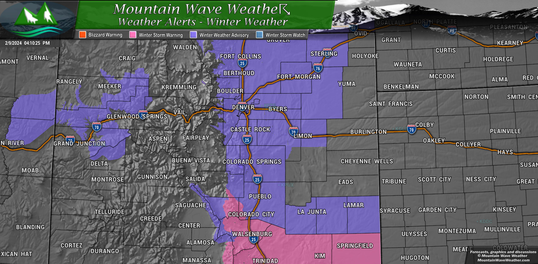
Winter Weather Advisory - Palmer Divide, Northern Colorado I-25 Corridor, Metro Denver, Colorado Springs/Pikes Peak Region
Issued: Friday, February 9, 2024
Timeframe: 5 AM Saturday, February 10 - 5 AM MST Sunday, February 11
Areas Affected: Palmer Divide, Northern Colorado I-25 Corridor, Metro Denver, Colorado Springs/Pikes Peak Region
Expected Impacts:
- Snowfall between 2 and 5 inches, with isolated amounts up to 6-8 inches possible over the Palmer Divide.
- Roads will become slick and hazardous, making travel difficult.
Please be aware of the following:
- Consider postponing travel if possible.
- If you must travel, allow extra time and drive with caution.
- Be prepared for winter driving conditions, including snow-covered roads and reduced visibility.
Winter Storm Warning - Huerfano, Las Animas, Baca Counties
Issued: Friday, February 9, 2024
Timeframe: 5 AM Saturday, February 10 - 8 AM MST Sunday, February 11
Affected Areas: Huerfano, Las Animas, and Baca Counties
Impacts:
- Heavy snowfall expected, with accumulations of 4 to 8 inches.
- Travel could be very difficult, especially during Saturday afternoon and evening when the heaviest snowfall is expected.
Be prepared:
- Consider postponing travel if possible.
- If you must travel, allow extra time and drive with caution.
- Be prepared for winter driving conditions, including snow-covered roads and reduced visibility.
- Monitor the latest forecasts and warnings from the National Weather Service at https://www.weather.gov/
- Follow local news reports for updates on road conditions and closures.
Stay safe:
- Ensure your vehicle is winterized with proper tires, fluids, and emergency supplies.
- Have a plan for staying warm and safe in case of power outages.
Updated Snowfall Forecast
Palmer Divide/Urban Corridor/Metro Denver
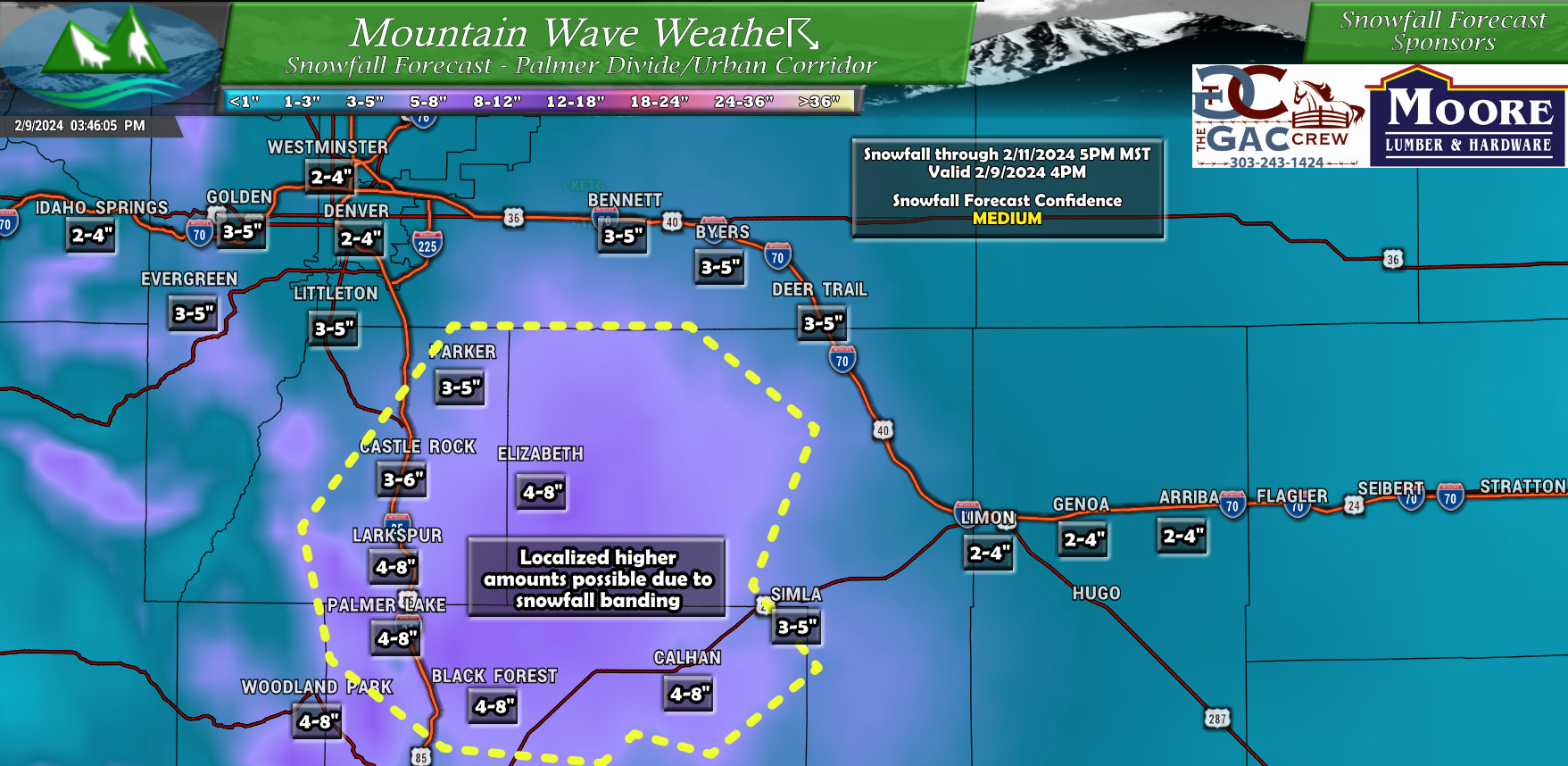
A few changes to snow along the Palmer Divide; most amounts have been adjusted downwards. I've still highlighted a good part of the Palmer Divide that could overperform due to snowfall banding. We can't predict this though, so I've highlighted just in case that area surprises us and end up above the forecast range. Models do show significant evidence of banding snowfall, but they are not good at nailing down strength, intensity or duration.
Northeastern Colorado
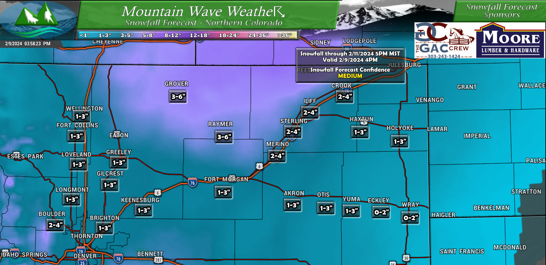
I included an updated map for Northern and Northeastern Colorado, mainly because the Southward shift of the storm track means many of these areas (especially along and West of I-25) will not realize the numbers we were seeing yesterday. Some heavier snow still possible along favored areas of the Cheyenne Ridge, but typically with storms like this, Denver/Greely, etc... get down-slope and don't get nearly as much snow.
Timing and Impacts
Timing: Snowfall starting this evening and tonight, lasting on and off through the day Saturday with clearing expected later Saturday and into Sunday
Accumulation: See snowfall maps above
Temperature: Low temperatures in the 20's Friday night and teens Saturday night. High temperatures will be in the upper 20's to low 30's on Saturday
Wind: Sustained winds between 5-10mph with gusts to 15mph. Not expecting strong winds with this storm. After the front passes late Friday, the wind direction will generally be out of the North
Travel impacts: Roads may become slick and hazardous due to the snowfall, particularly during the overnight hours. Consider allowing extra travel time and driving with caution if you must be out on the roads.
Summary
Storm is still on the way, timing mostly looks on track if not a tad bit later.
Either way, be prepared for rapidly changing road conditions tonight and into Saturday, especially South of Denver.
