Latest update regarding our end of week storm. Some fairly significant modifications made to the snowfall forecast, especially around the Palmer Divide and Denver. Additionally, I’ve included updated winter weather highlights and timing/impact information.
Storm Related Weather Highlights
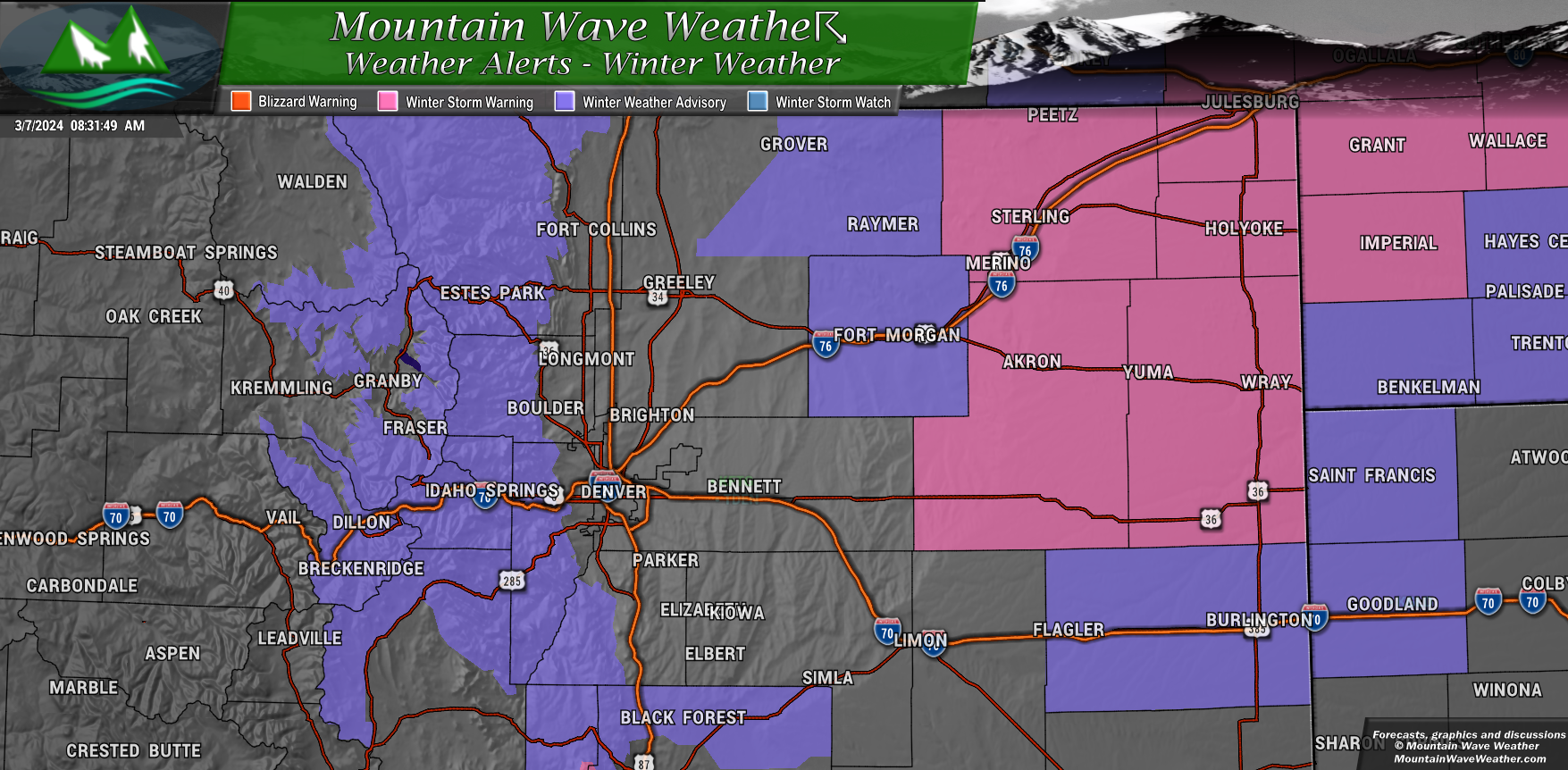
A Winter Storm Warning is in effect from 5 AM early this morning to 11 AM MST Friday for:
- Sterling and Akron in Logan and Washington Counties.
Here’s what to expect:
- Heavy snow: Accumulations between 2 and 10 inches, with some areas potentially receiving even more.
- Travel will be very difficult.
Stay safe!
- If you must travel, be prepared for dangerous road conditions.
- Pack an emergency kit in your car, including a flashlight, food, and water.
- Check road conditions before you travel.
A Winter Weather Advisory is in effect from 11 AM this morning to 5 PM MST Friday for the following areas:
- Rocky Mountain National Park and the Medicine Bow Range
- Mountains of Summit County, the Mosquito Range, and the Indian Peaks
- Northern and Southern Front Range Foothills
Here’s what to expect:
- Snow: Accumulations of 5 to 11 inches.
- Travel conditions: Snow-covered roads will make travel hazardous, especially during commutes on Thursday evening and Friday morning.
Stay safe!
- Slow down and use caution while driving.
- Check road conditions before you travel. You can call 5 1 1 or visit https://www.cotrip.org/map.htm for the latest updates.
A Winter Weather Advisory is in effect from 8 AM this morning to 11 AM MST Friday for:
- Briggsdale and Fort Morgan in northeastern Weld and Morgan Counties.
Here’s what to expect:
- Up to 5 inches of snow possible, mainly in the far eastern parts of these counties.
- Slippery road conditions are likely.
Stay safe!
- Slow down and use caution while driving.
- Check road conditions before you travel. You can call 5 1 1 or visit https://www.cotrip.org/map.htm for the latest updates.
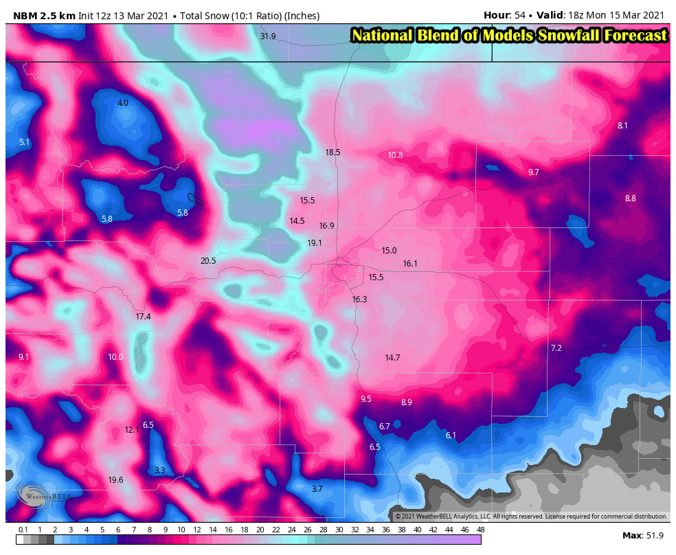
Snowfall Forecast Updates
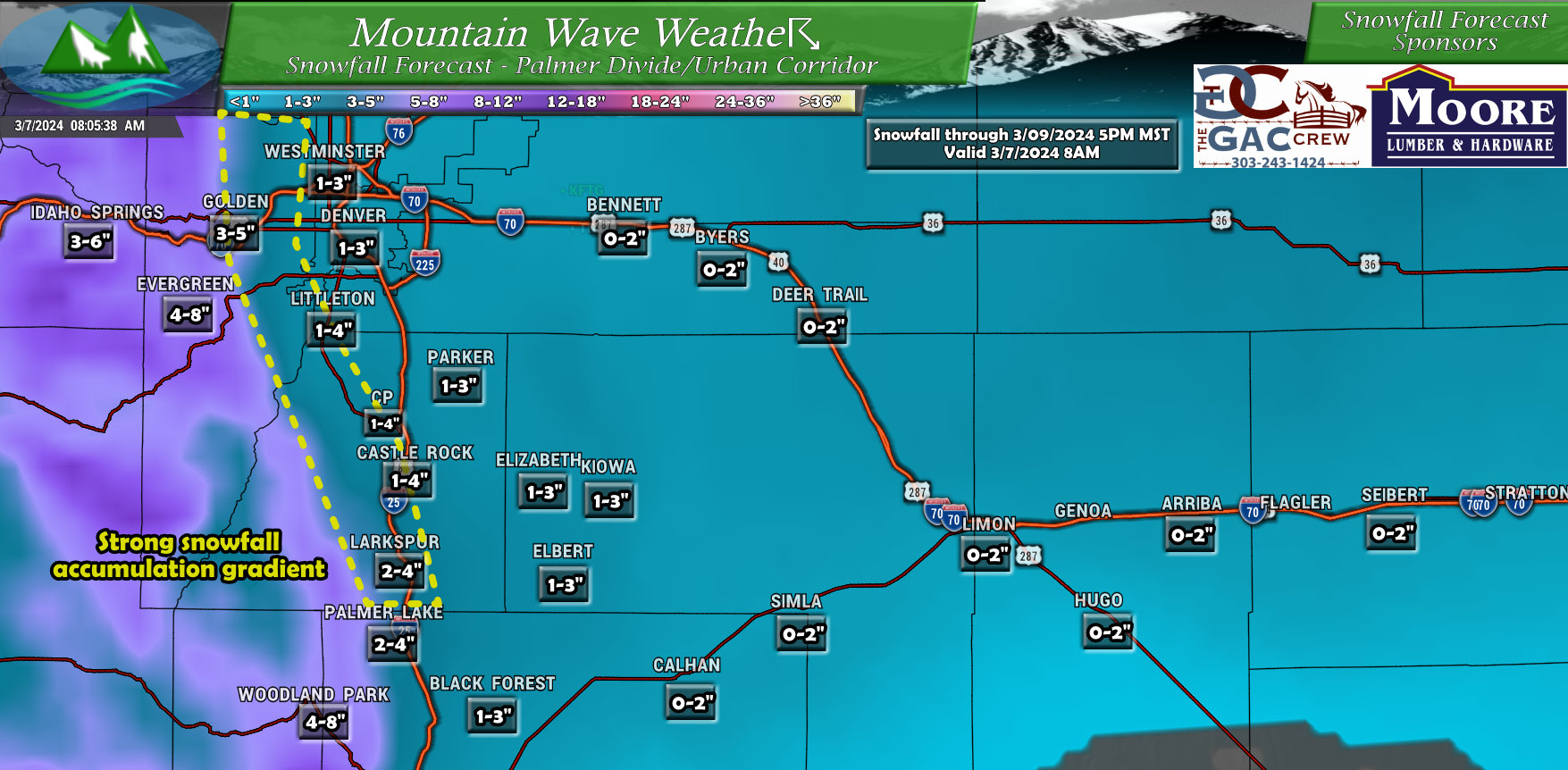
Denver/Palmer Divide
Major changes were made to the snowfall forecast for Denver and the Palmer Divide. Snowfall amounts overall were shifted downwards, the storm still looks disorganized on many models and the tendency is to trap a lot of the moisture needed for upslope to the East and Northeast. This means we would be limited in moisture and would only favor the higher elevations right up against the foothills for higher snowfall mounts.
Additionally, there will be a strong and narrow snowfall accumulation gradient. This is why you see wider ranges in that area (pointed out on the map below) for example a place like Castle Rock may only see 1-2″ in the eastern parts of town, while the Western parts of town could see 3-4″. This will be the case with many areas within that snowfall gradient “band.”
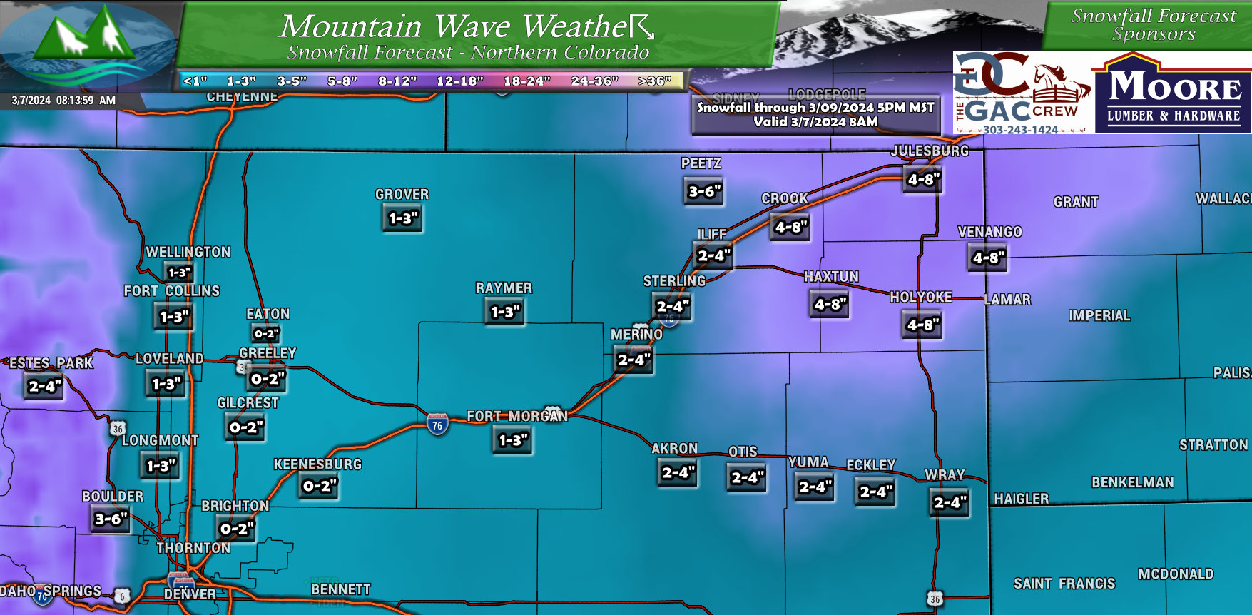
Northeastern Colorado
Mostly the same as the last, but you can see the higher amounts now shown in the Northeastern part of the state. This is the moisture that looks to get trapped in that area. As such, many of those folks are already seeing snow this morning and will continue to see moderate to heavy snow throughout the rest of the storm’s duration (into Friday.)
NWS did issue that Winter Storm Warning for that area, so confidence is higher there for more snowfall and potentially dangerous travel conditions.
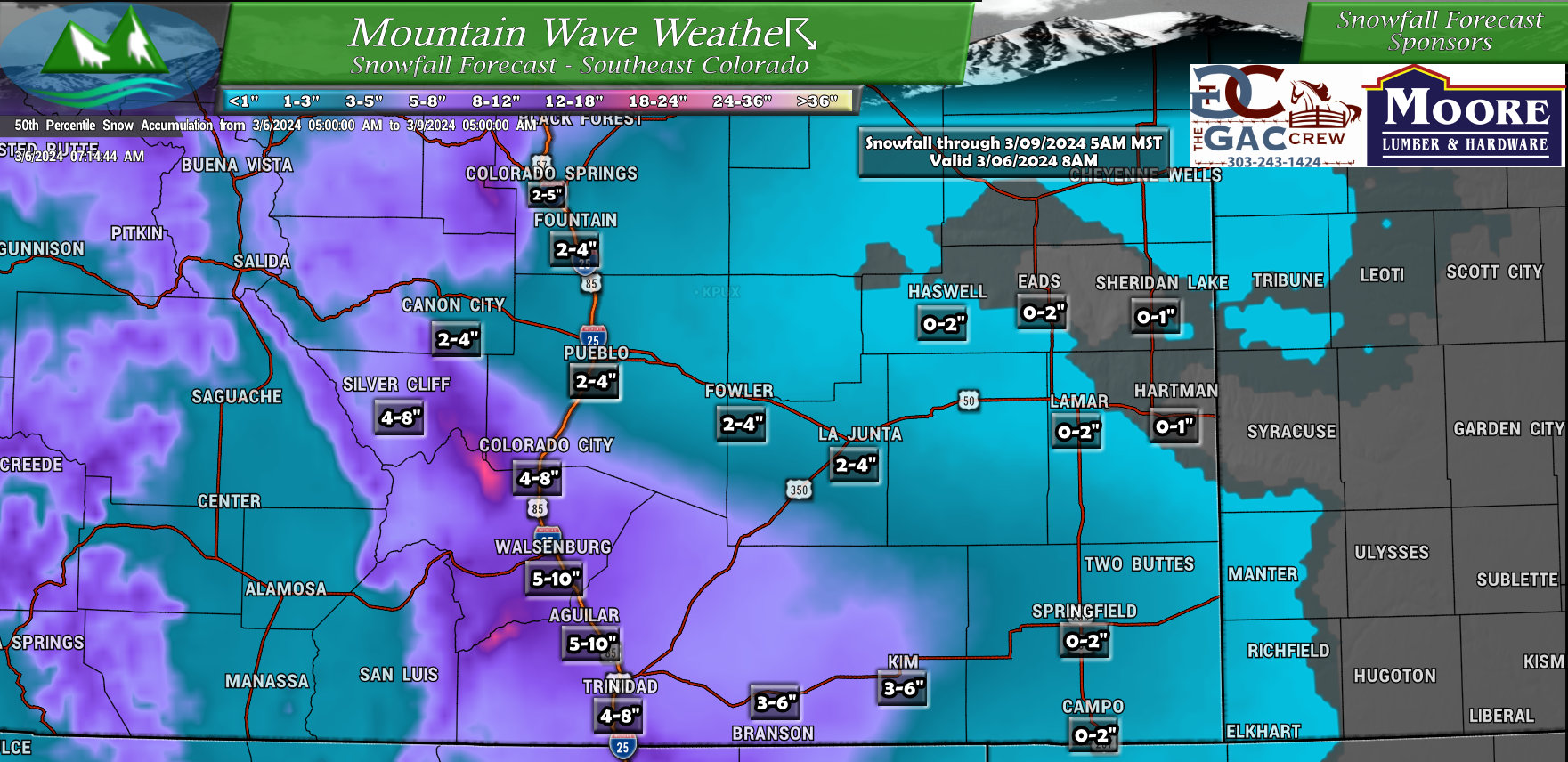
Southeastern Colorado
-No changes from previous forecast
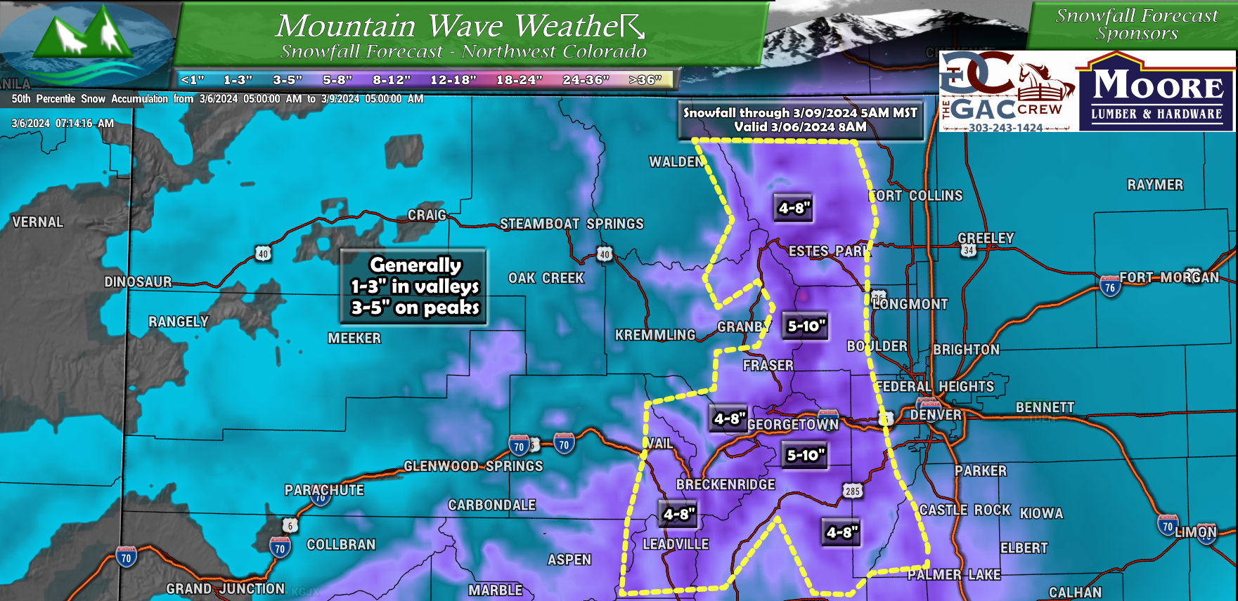
Northwestern Colorado
-No changes from previous forecast
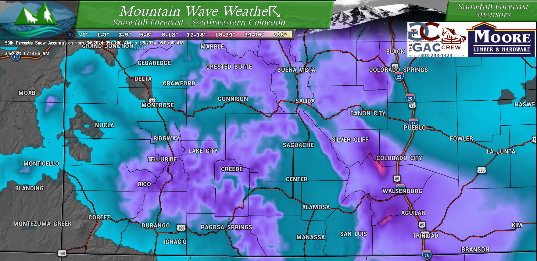
Southwestern Colorado
-No changes from previous forecast
Timing and Impacts
Here’s the thoughts on timing and impacts, first for the Palmer Divide, foothills and I-25 corridor, but have also included some of the troublespots to the East and Northeast should you be traveling up that way today or tomorrow:
Mountains, Foothills, & I-25 Corridor
- Timing: Snow showers starting this afternoon.
- Impacts:
- Mountains & Foothills: Hazardous travel due to moderate to heavy snow showers at times (snowfall rates up to 1 inch per hour).
- Snowfall accumulation:
- Mountains & Foothills: 5 to 11 inches (Winter Weather Advisory)
- West of I-25: 1 to 4 inches
- East of I-25: Trace to 2 inches
- Eastern Boulder & Jefferson Counties: Potential need for a Winter Weather Advisory due to higher snowfall amounts on the west side of cities like Boulder and Golden.
Far Northeast Colorado (Logan, Phillips, Sedgwick, & NE Washington Counties):
- Timing: Heavy precipitation (snow or rain) starting mid-morning, possibly continuing all day.
- Impacts:
- Winter Storm Warning: Dangerous travel conditions due to heavy, wet snow with possible snowfall rates of 2-3 inches per hour.
- Snowfall accumulation: 4 to 10 inches, potentially reaching 12-16 inches if all precipitation falls as snow.
- Uncertainty: Possibility of lower snowfall amounts (closer to 4 inches) if precipitation falls mostly as rain.
Northeast Weld & Morgan Counties:
- Timing: Uncertain; potential for heavy snow if the main precipitation band shifts westward.
- Impacts:
- Winter Weather Advisory: Possible hazardous travel conditions due to snow.
- Snowfall accumulation: Up to 5 inches, but highly dependent on the precipitation band’s movement.
Summary
So while I won’t say this storm will be a big snow maker for many of us, at some points in some locations the snow may be moderate or borderline heavy in intensity. This means that even though accumulations overall look light, there may be travel headaches around the urban corridor and Palmer Divide.
Any of those impacts will probably manifest later in the day on Thursday, overnight and into Friday. So be prepared for that.
If you have animals; not looking like a particularly cold or snowy storm, so temperatures probably won’t be much of an issue for larger animals and the snow won’t pile up enough that it should cause any problems.
For those of you concerned about the wind; it looks pretty light throughout the duration of this storm. We are not expecting any blowing/drifting snow or visibility issues due to wind.
As always, I’ll have more information if needed!
