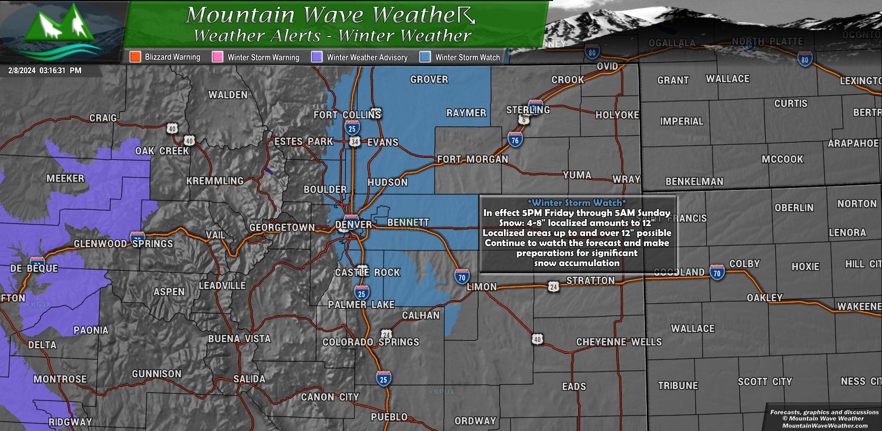
Includes I-25 corridor from Colorado/Wyoming border South to Monument and Palmer Lake, Metro Denver, Central East Colorado, Douglas County along the Palmer Divide and Elbert County locations along the Palmer Divide above 6,000 feet in elevation
The watch timeframe is in effect from 5PM Friday evening through Sunday morning at 5AM
Localized areas of significant snow accumulation are possible.
* WHAT…Heavy snow possible. Total snow accumulations between 4 and 8 inches with locally higher amounts up to 12 inches possible. This includes the Front Range Foothills, Palmer Divide, Urban Corridor and adjacent plains.
* WHERE…Portions of central, north central, and northeast Colorado.
* WHEN…From Friday afternoon through late Saturday night.
* IMPACTS…Travel could be very difficult. Be prepared for snow packed and icy roads.
* ADDITIONAL DETAILS…There is quite a bit of uncertainty in the
models on where the heavier snowfall will occur.
A watch means preparations for severe winter weather should being. Plan to have all preparations completed by Friday afternoon. Main hazards will be low visibility, moderate to sometimes heavy snowfall intensity and significant accumulation of snow up to 1 foot
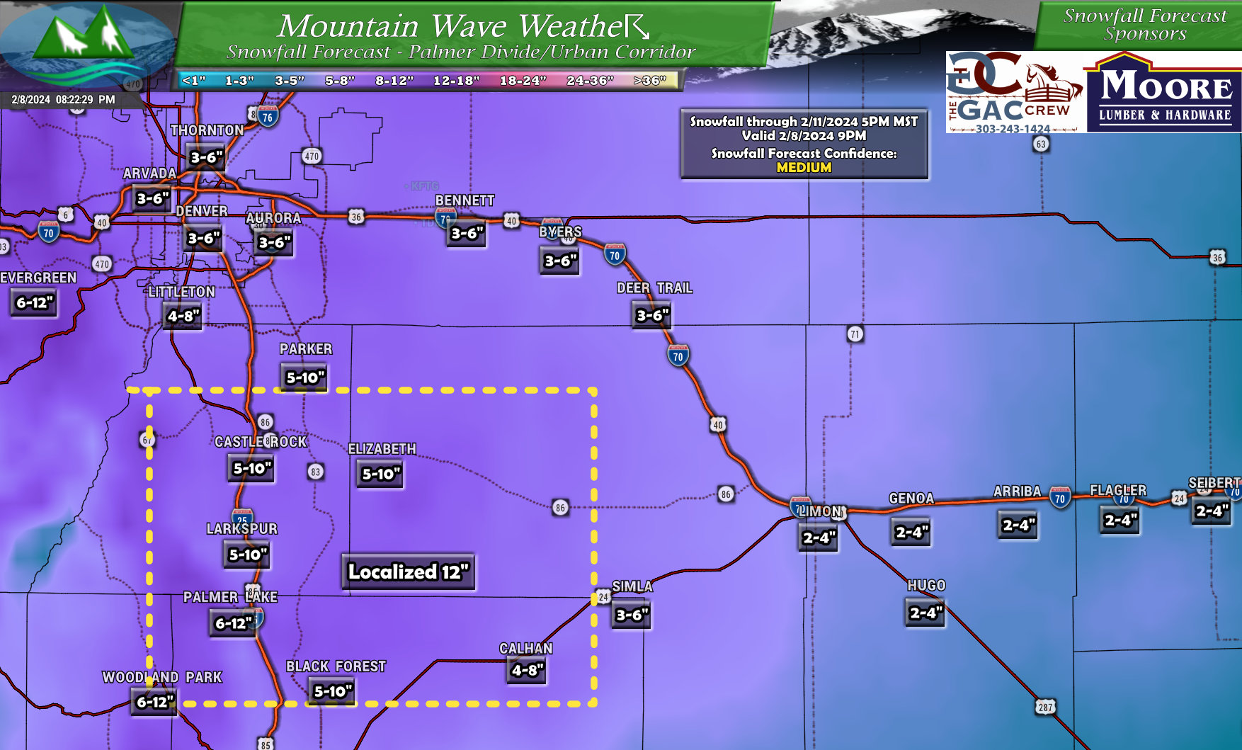
Snowfall Forecast
Palmer Divide/Urban Corridor
As you can see, parts of the Palmer Divide are favored for higher snow totals again with this storm. Not due to temperatures this time, but due to favorable terrain and areas most likely to see the best upslope due to that terrain. Many areas along the Palmer Divide should find themselves in that 3-6 or 4-8 or 5-10 inch range. There are some localized areas that may see up to 12″ / 1 foot of snow. So overall, could see similar amounts to the last storm that rolled through roughly a week ago.
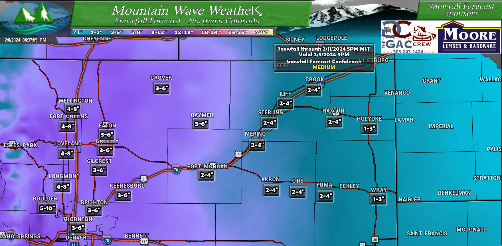
Northeastern Colorado
Areas closest to I-25 and the foothills will have the best shot at higher snow totals with this storm in Northeastern Colorado. As you move onto the plains, the terrain will not influence lift as much so snowfall amounts should tail off as you go further East.
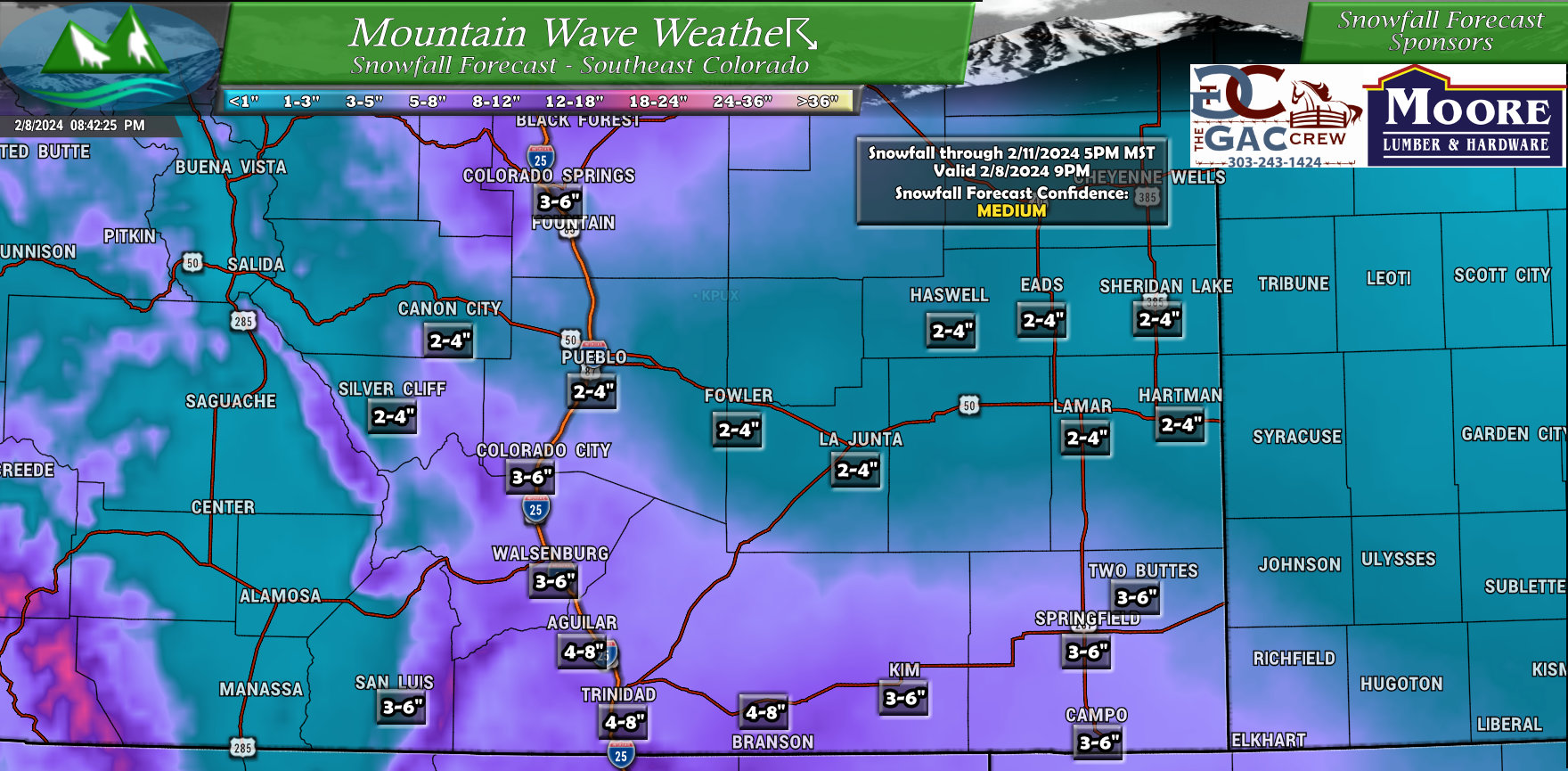
Southeastern Colorado
Noticing the theme yet with this storm? Areas along and close to the Palmer Divide will be favored for higher snow totals, as will elevated areas to the South such as the Raton Mesa. As you go further East, snow totals will drop off, but not quite as quickly as in Northeastern Colorado. This is mainly because this storm system has a more Southerly track and has more energy to the South.
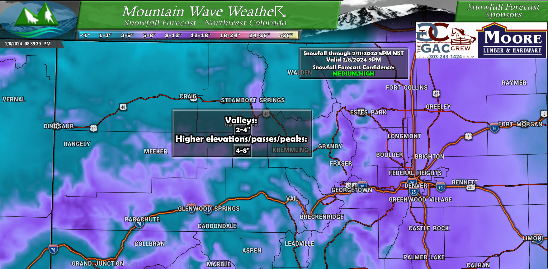
Northwestern Colorado
Broad brushed the forecast map for Northwestern Colorado, it won’t be a particularly favorable storm for most mountain areas. Still some of the higher peaks and passes could see totals range in the 4-8 inch range. Not enough to cause major issues, but enough to cause some headaches… or good skiing if you’re heading up for that.
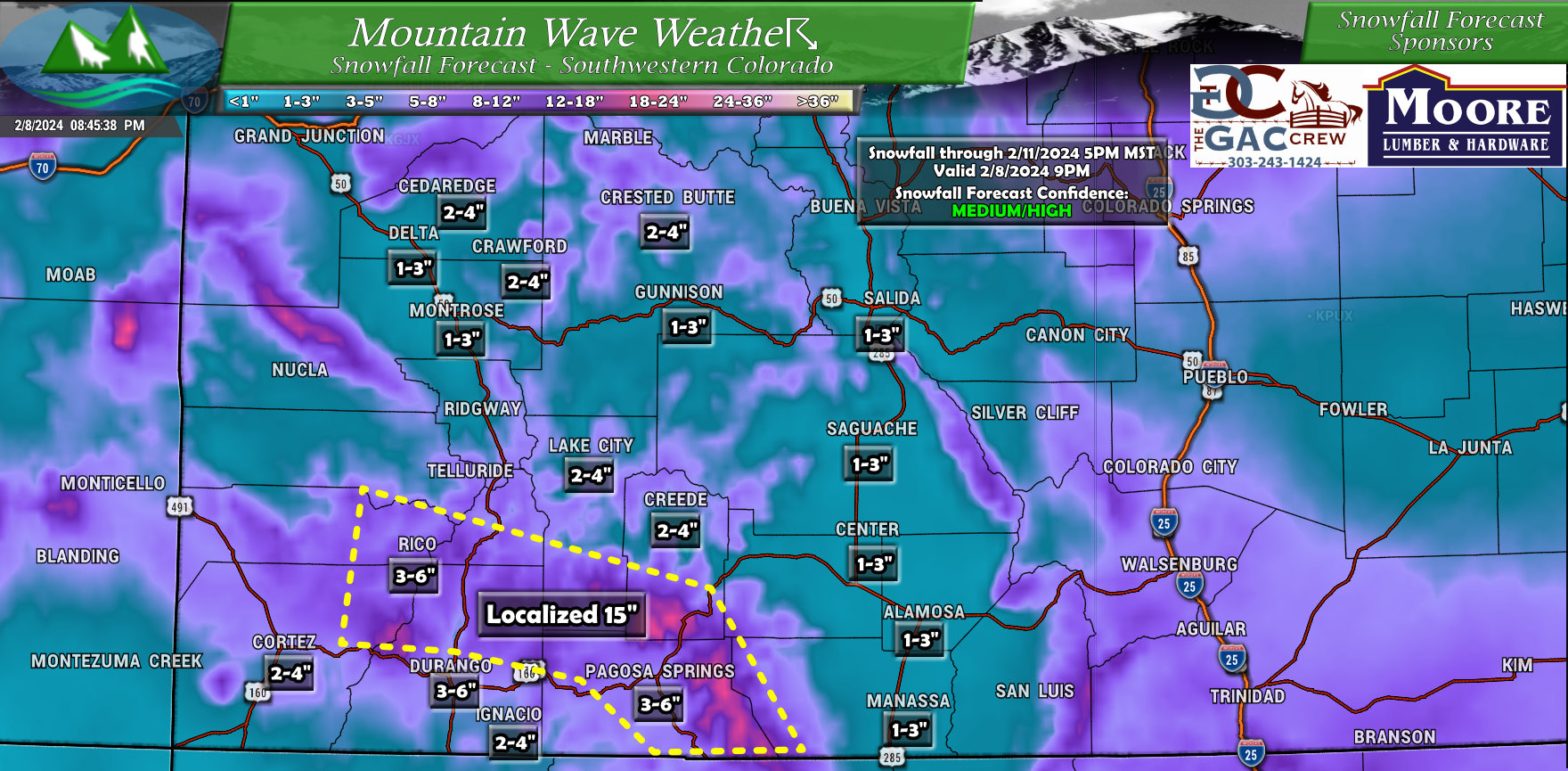
Southwestern Colorado
For Southwestern Colorado, there will be some pockets of higher snowfall accumulation. Mainly along favored peaks and terrain near Durango and Telluride. These areas could see totals in the 3-6″ or 4-8″ but some localized pockets of 12″ to 15″ are possible. Probably expect some travel issues down this way.
Additional Comments on Timing and Forecast Confidence
Forecast confidence is overall medium on these snowfall amounts in Eastern Colorado. Confidence in the mountains is higher.
Is that because this storm is like the last? Not exactly, one concern that could drastically alter the forecast is the amount of available moisture the system has as it moves into Colorado. The other is exactly how much upslope is realized when the storm gets here.
If these two pieces don’t come together, this forecast will change drastically on Friday or could result in the forecast busting as the storm moves through. I’ll be keeping a close eye on data through the day on Friday to see how this call comes together.
The second issue is with timing, this is total snowfall through Sunday afternoon. There are 2 waves of snow possible with this storm system; the first being early Friday morning. Amounts should remain light and travel impacts minimal with this first wave.
The second wave arrives Friday evening, this wave could have potentially moderate to heavy snow associated with it. If we’re going to see travel impacts, they are most likely Friday night and into Saturday morning… so keep that in mind.
Be prepared for rapidly changing road conditions Friday evening and into the overnight hours.
That’s it for tonight! Be sure to stay tuned for additional updates on Friday.
Have all preparations completed by late Friday afternoon at the latest!
John R. Braddock is a NOAA/NWS Certified Storm Chaser and Amateur Meteorologist living in Castle Rock, Colorado. A graduate of Colorado State University with a Bachelor's in Computer Science and a Colorado native, he specializes in short range forecasting, severe weather and mountain weather dynamics.


How come I don’t see your emails anymore for whether?