First, A Note About This Week’s Weather
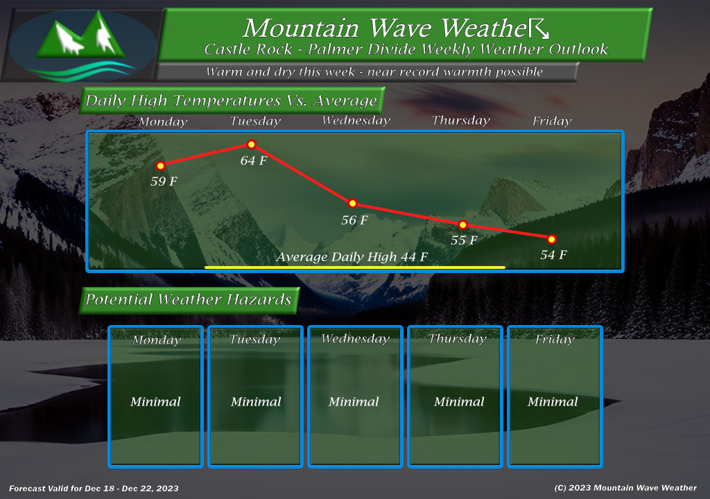
Before we get to the fun stuff, here’s a look at this week’s expected weather. In a sense, it’s going to be warm!
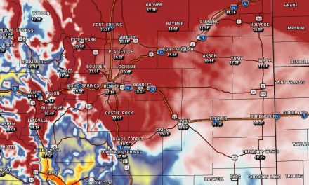
Near record warmth is expected across the front range of Colorado this week.
Potential Christmas Storm Setup
If you’re looking for finer details such as how much snow we get, who sees the most snow, what time the snow hits your house… etc… you’re not going to find that here. Why? Because it would most likely be wrong at this point in the game. We are 6 days out from the arrival of this storm and model uncertainty is quite high right now, so anyone claiming they know what is going to happen is selling something!
Let’s take a look at what we are watching this week and into the weekend:
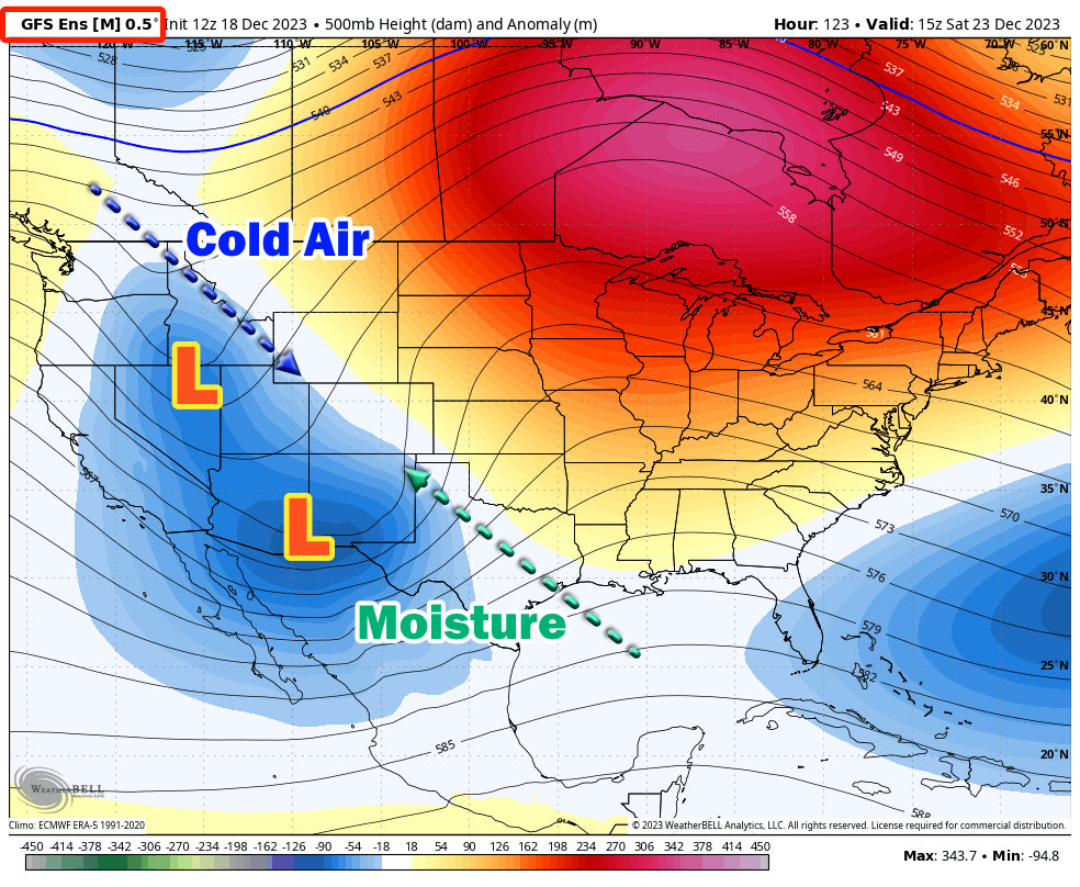
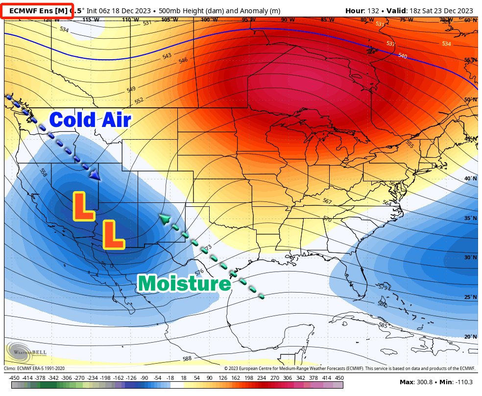
I’ve posted the ensembles of the GFS and the Euro above, please note that deterministic models are fairly useless at this point in the forecast game. Anyone posting them either doesn’t know what they’re doing or doesn’t care.
The 500mb height anomaly shows areas of lower height (blues, greens – low pressure) and higher heights (oranges, reds – high pressure) and is a great tool to to see some of the synoptic features of any storm system setting up.
Notice that both models show two areas of low pressure building off to our West. A low tracks in from Southern California, should things come together this feature would be responsible for pumping moisture up into Colorado. The other feature is a low pressure system swinging out of the Pacific Northwest – this would be responsible for bringing colder air to Colorado allowing for snow and snow accumulation.
What does this show us right now? It shows us we need to watch these two features very closely to see how they evolve.
A Couple of Scenarios
How these two low pressure systems interact and where they track will make a huge difference in what we see with this storm system.
I’d like to point out that while a storm system that could bring snow to our neck of the woods is on the table, there are equally many model solutions that believe we see no snow out of this and just a ton of wind. So don’t get to thinking one solution or another is the right one just yet.
With the uncertainty, we don’t yet know exactly what will happen – but we can hazard a couple of guesses based on how a couple of scenarios play out. Keep in mind, at this point in time the probability of any one of these scenarios occurring is roughly equal to the other, it will be my job over the next few days to ascertain which scenario starts looking more likely and then nailing down the finer details around that scenario (how much snow, who gets the most snow, timing, impacts, etc…)
- Lots of snow
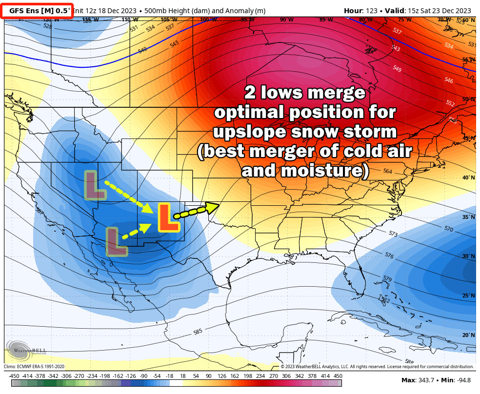 In this scenario the two low pressure systems merge (or phase together) and take an optimal path across the four-corners region, Colorado/New Mexico border and to the East. Assuming the storm was in the right phase and didn’t speed up too much, this would allow colder air to work down from the North and ample moisture to stream up from the South. This solution would be the best for a higher end snowfall event along the front range.
The GFS Ensembles have the highest number of members showing this solution – so the GFS deterministic and GFS Ensemble models show higher end snow totals along the front range of Colorado.
- Some accumulating snow
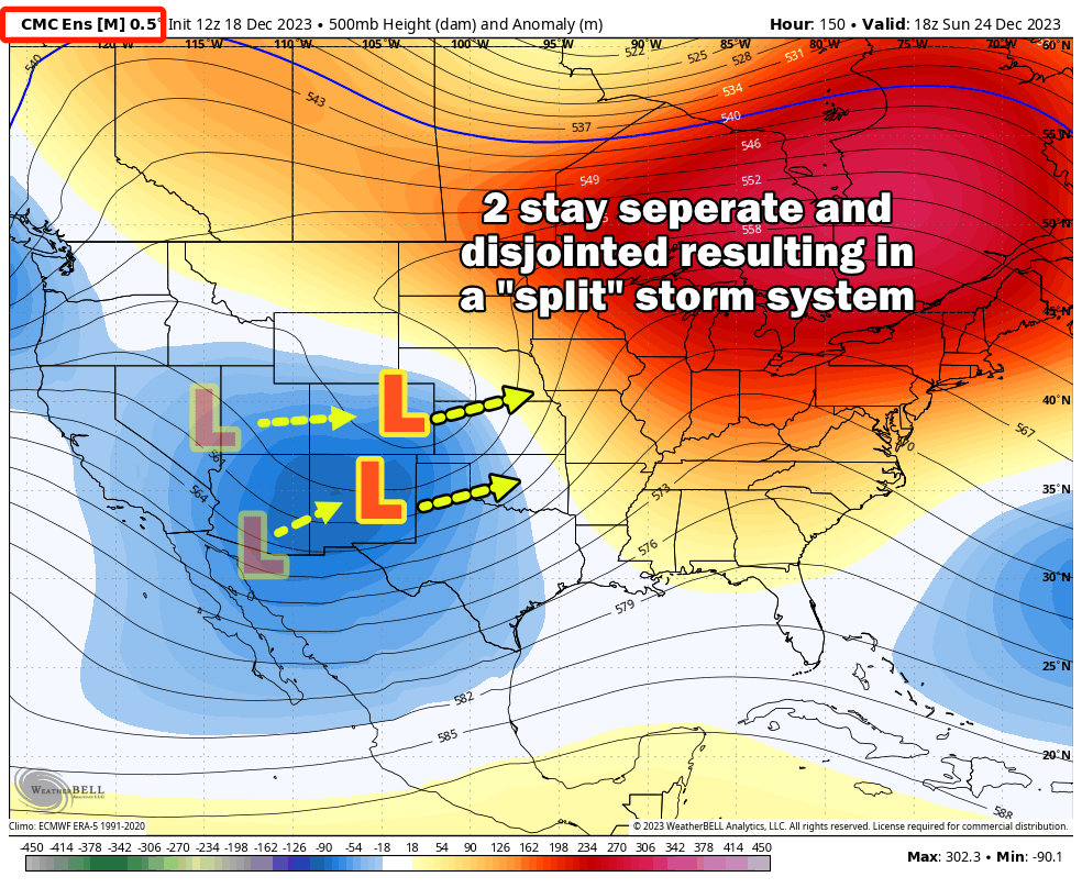
The Canadian and Euro Ensembles have the highest number of members showing this solution – so both sets of ensembles and deterministic models show a light/moderate snowfall event along Colorado’s front range during this time.
- No snow at all
At this time, I don’t have graphic for this scenario as most models are showing some type of snow event for Colorado. That being said, this scenario would occur if the lows split too far North and South, moves through at drastically different times or were shredded apart as they cross the mountains and did not regenerate East of the Rockies.
I will say that as of this morning’s data – this is currently the least likely scenario but this could still change.
Summary and Forecast Notes
We are still very early in the forecast process for this storm so a lot can change one way or another. Here’s my messaging for this storm system:
- Keep checking the forecast throughout the week for changes (they will happen day-to-day)
- Do not trust your dumb weather app (they are terribly inaccurate and I’d bet money it’s going to bounce to 50 different solutions each and every day including some outliers that are highly unlikely – my job is to filter garbage like that out.)
- Timing: best guess is later Saturday and Sunday for snow (this will still change, but that’s what I see right now)
- Impacts: no idea at this point in the game
This storm has my attention; someone is going to likely get hammered with a decent amount of snow and cold right before Christmas… the million dollar question is will it be us in Colorado or further North into Wyoming/Nebraska or further South into New Mexico. All of those areas will be in play for this storm system.
