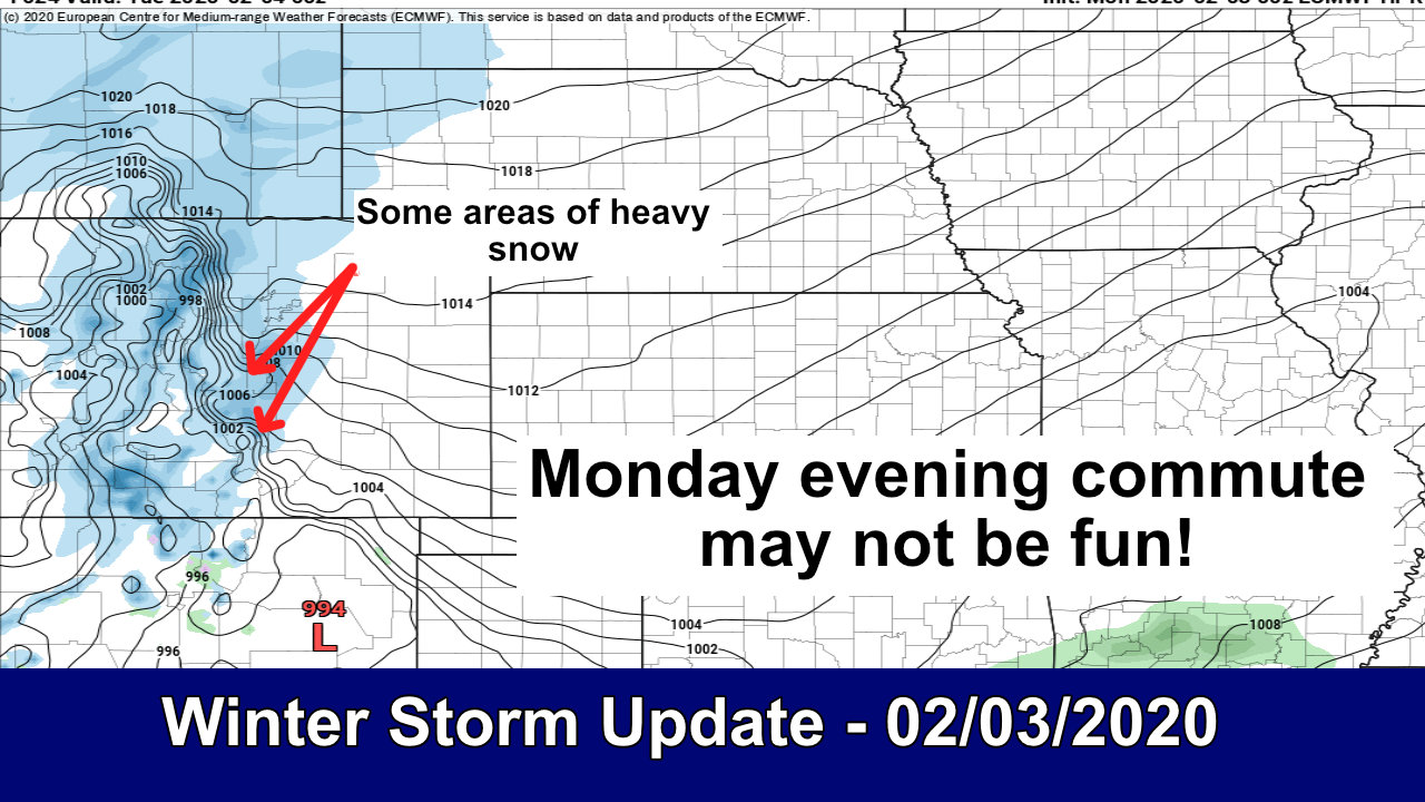
A very complex forecast on tap for this weekend’s “Christmas” storm. Models are still all over the place so we still have lower end confidence on how this thing will ultimately play out. What I’m going to do in this post is present what my thinking is, what we can cobble together with today’s snowfall and model run data and see if we can get some sort of forecast set up.
I do want to highlight this one fact: we don’t really know what this storm is going to do at this point. Models are still fairly useless… but there is an equal chance this storm does little/nothing at all OR becomes a pretty decent sized snowmaker with travel impacts and issues.
Since that second scenario is still possible, my messaging is the same; be prepared for travel impacts, falling snow and gusty winds to the East of Denver late Saturday, Saturday night and into Sunday. Be prepared for it.
For reference, here’s what the various models say for Castle Rock.
Euro (Det): 3.0
GFS (Det): 7.0
Euro (Ens): 3.5
GFS (Ens): 4.0
Nam3k: 2.0
NBM: 5.0
All over the place! That being said, with a bit of experience, “gut instinct” and magic, I’ve filtered out a lot of the noise and outliers and settled on the 3-6″ range as most likely for Castle Rock right now. You can see the ranges I settled on for other locations in the snowfall forecast below.
If this storm ends up falling apart and does nothing, that’s cool. But if it goes the other way, you’ll be prepared. See how that works? Awesome!
Let’s get into the good stuff!
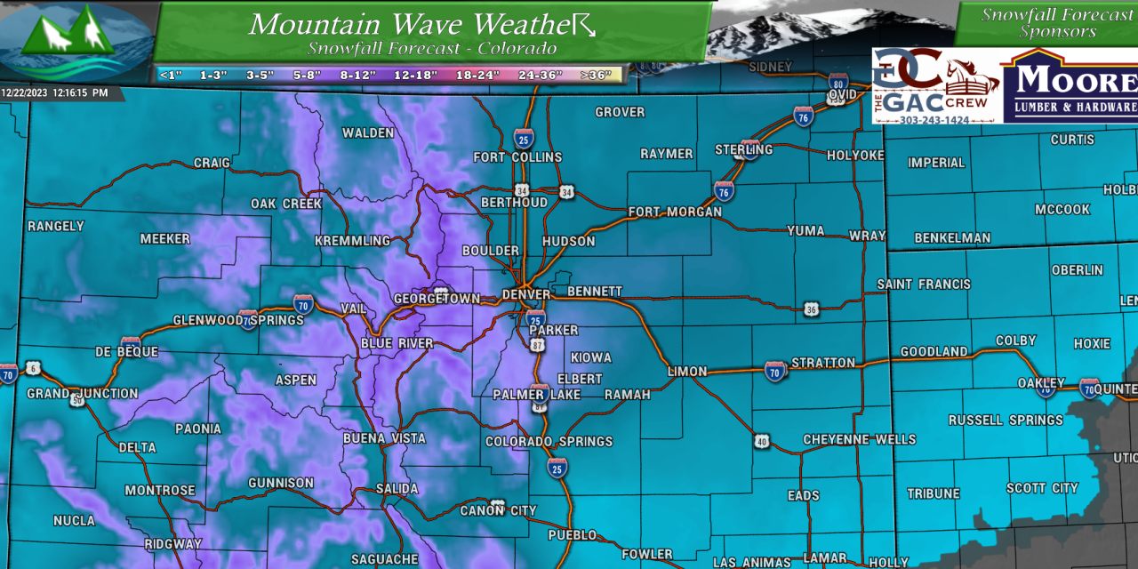
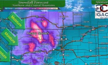
Colorado Snowfall Forecast
All snowfall graphics are valid as of 11AM on 12/22/2023
Forecast confidence in snowfall for the mountains is medium/high
Forecast confidence in snowfall amounts for the plains is still low to medium/low
Palmer Divide/ Denver Metro
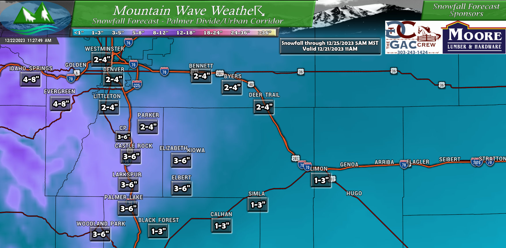
One thing models have been consistent on is Northerly flow and higher elevations making a transition to snow quicker. That means higher altitude areas such as the Palmer Divide South of Denver and the Foothills to the West of the City will be favored for higher snowfall accumulation. This is reflected pretty well in the snowfall amounts on the map above, generally see a 3-6″ accumulation spread across the Palmer Divide with a drop off as you go East and generally 4-8″ for those foothills locations West of Denver.
This snowfall forecast may still change over the next day or so since confidence is on the lower end with these numbers. The best way to read this map is not to focus so much on exact amounts but look for areas that have overall higher and lower amounts – that should give you an idea of what areas we are zeroing in on for higher snow accumulation.
Keep checking back for snowfall forecast updates!
Northeastern Colorado
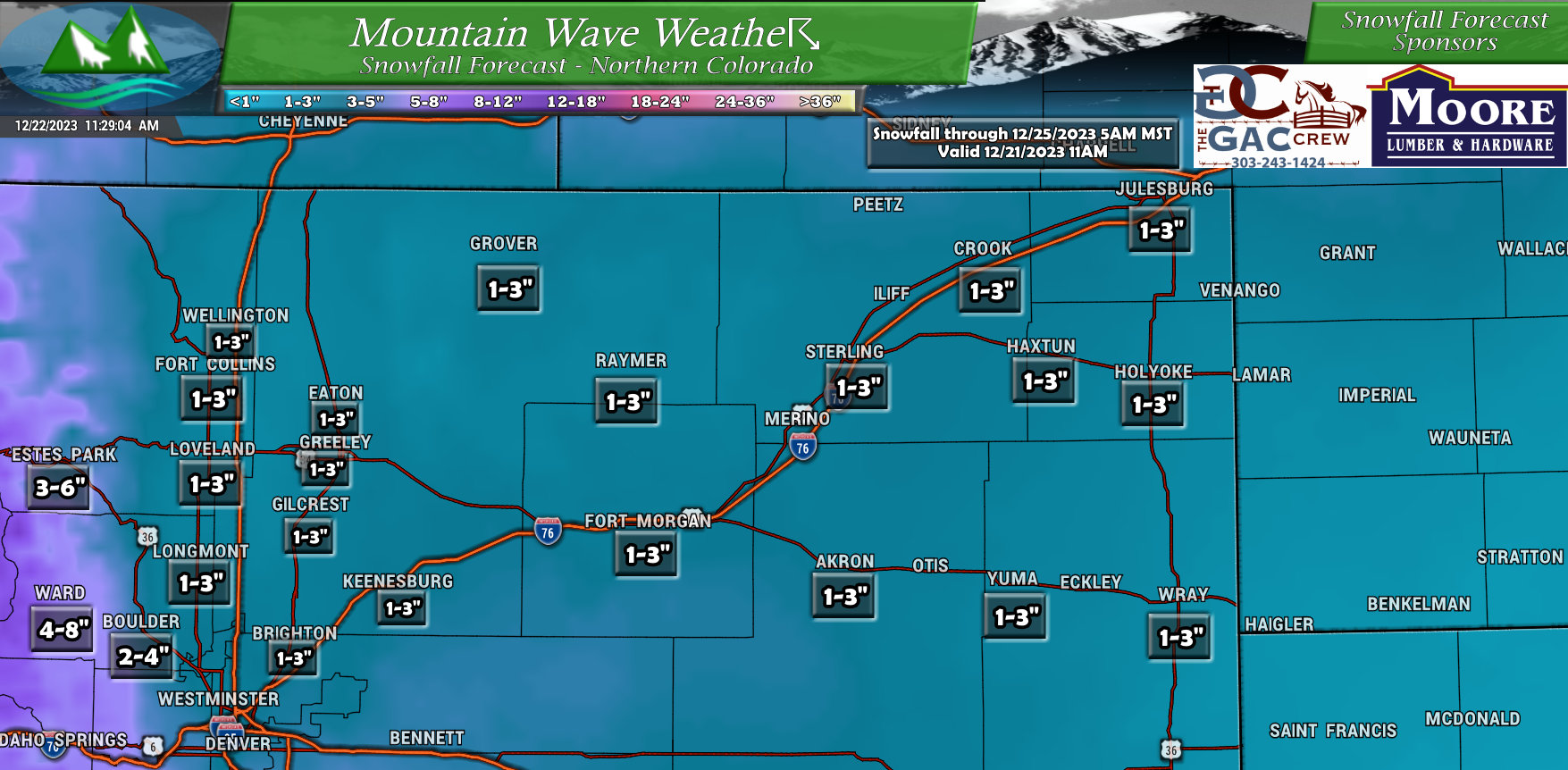
Not too much going on for Northeastern Colorado, many areas will be in that 1-3″ range and I would not be surprised to see Fort Collins, Loveland and Greeley end up on the lower side of this range due to down-sloping off of the Cheyenne Ridge. Drying of the air and unfavorable orographics (in this case sinking air due to terrain) could mean this area ends up seeing lesser snowfall.
Southeastern Colorado
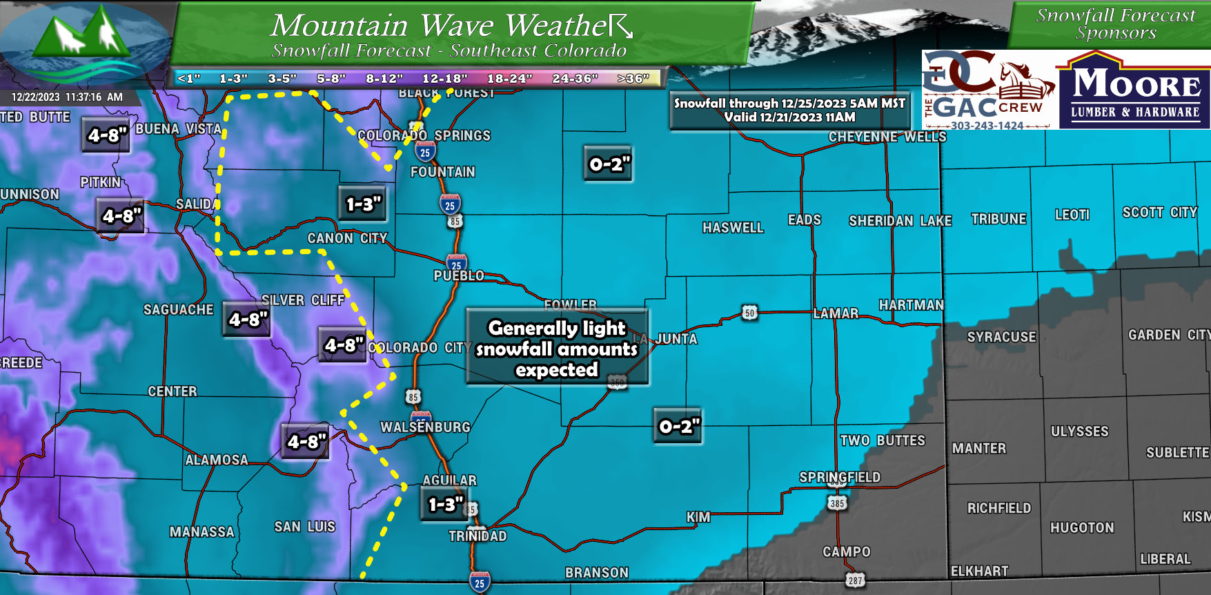
Most of the Southeastern part off the state won’t see much snow, but rain is a possibility. Given the track of the storm, if the low passes through this area it would be unfavorable for snow and we could see more of a wind threat. Further to the West, the mountains will pick up 3-6″ or 4-8″ depending on the mountain range you’re looking at.
Northwestern Colorado
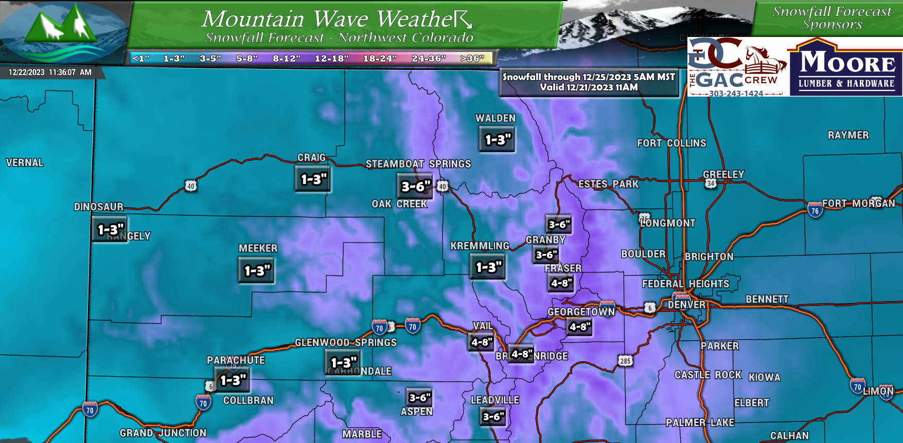
Areas along the Continental Divide will be favored for higher snowfall with this storm. This should be good news for ski areas still hoping to build their snowpack up. Look for good powder days at Winter Park, Vail, Breck, Keystone, Loveland and A-Basin. Steamboat may do fairly well with a reinforcing shot of snow as well, but may not see quite the higher end totals that those along the Front Range mountains do.
Southwestern Colorado
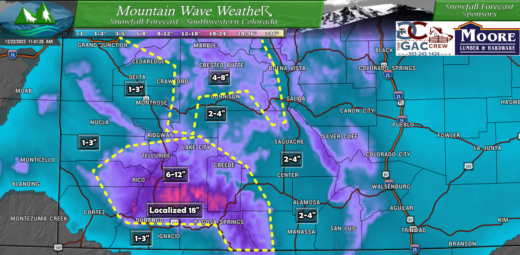
Winners for snow totals with this storm will likely be the favored terrain areas North of Durango and Pagosa Springs, in and around Telluride and Crested Butte. The areas North of Durango should settle in the 6-12″ range but some areas are showing up to 18″ of snow!
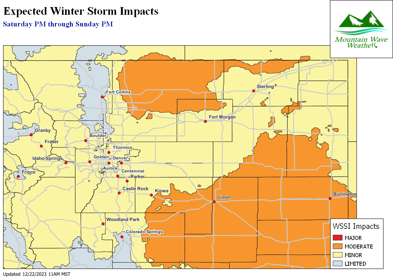
Potential Timing and Impacts
At this time, it looks likely the most impactful weather will be late Saturday (evening hours) through Sunday afternoon. Since we still have considerable uncertainty between the models on the storm’s speed and arrival – this may change a few hours either way. For now though, this should give you enough of a timeline to know when to expect travel impacts due to Weather.
One major component across the Palmer Divide and points East will be the addition of gusty winds while it is snowing… this means travel could become difficult due to icy/snowpacked roads and visibility may become an issue.
Stay tuned for updates on this from a forecast perspective.
Summary
There it is! This is what we have going for us this morning – keep in mind confidence on the snow amounts is still quite low so there is a chance this thing turns out to be a complete dud. That being said, there is a similar chance it becomes what I like to call a “headache” storm.
All messaging at this point is to “be prepared” in case the storm does materialize and cause issues across the area. That’s the best we can do from a forecast perspective at this time until/unless we see better model agreement. At this point, I’m not sure we will so we’ll just have to wing this one a bit!
More forecast updates as we get more information in, stay tuned!

