No secret the wind has been the main story when it comes to our weather for the past week or so. At my station alone I’ve seen several consecutive hours of sustained winds in the 20-30mph range with some gusts topping 30mph. Not the windiest we’ve ever seen but notable nonetheless.
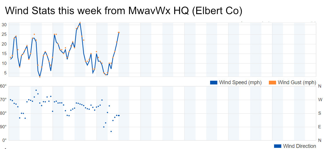
Weekly wind speed and direction from my weather station on the Palmer Ridge. (As of 12PM 1/15/2020
Why So Much Wind?
In a nutshell, we don’t tend to do well with split jet stream patterns, which is what we’ve experienced in combination of occasional ridging for the past couple of weeks. All that put together translates to dry and windy conditions along the front range, with an occasional warm day here and there. We’re not seeing strong enough downslope to really give us a decent “chinook wind” day and push the temperatures above about 50 or 60.

A split jet stream pattern is in place – here’s the 500mb upper air chart from the GFS
If we take a closer look you can see how a lot of the storms we’ve gotten recently have been riding that split pattern and coming almost due West into Colorado. This is generally good news for our ski resorts as they can get consistent storms and snowfall, but for the front range the mountains trap a lot of that moisture. Sadly, we tend to miss out on a lot of storms when the weather pattern is like this East of the Continental Divide.
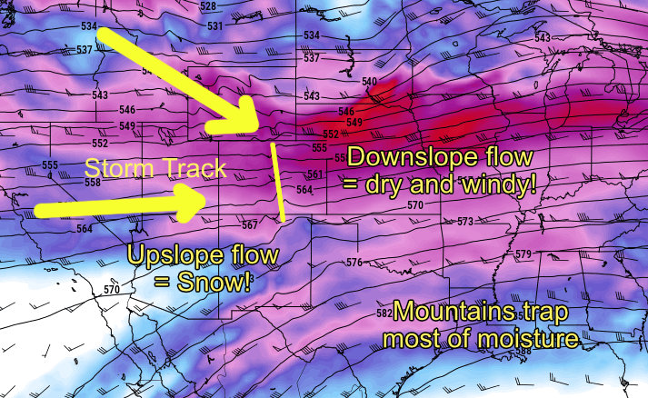
The mountains do a great job of catching and wringing out the moisture from these pacific tracked storms. Sadly it means there’s little left for us along the front range outside of windy days.
Rest of This Week
When I look into the crystal ball I don’t see much change to this pattern the rest of this week. The wind will stick around and may intensify a bit over the next couple of days as the jet continues to roar overhead. Depending on how the atmosphere sets up, those winds will get pushed down the rockies to the surface (downsloping), that looks like a pretty good bet so far.
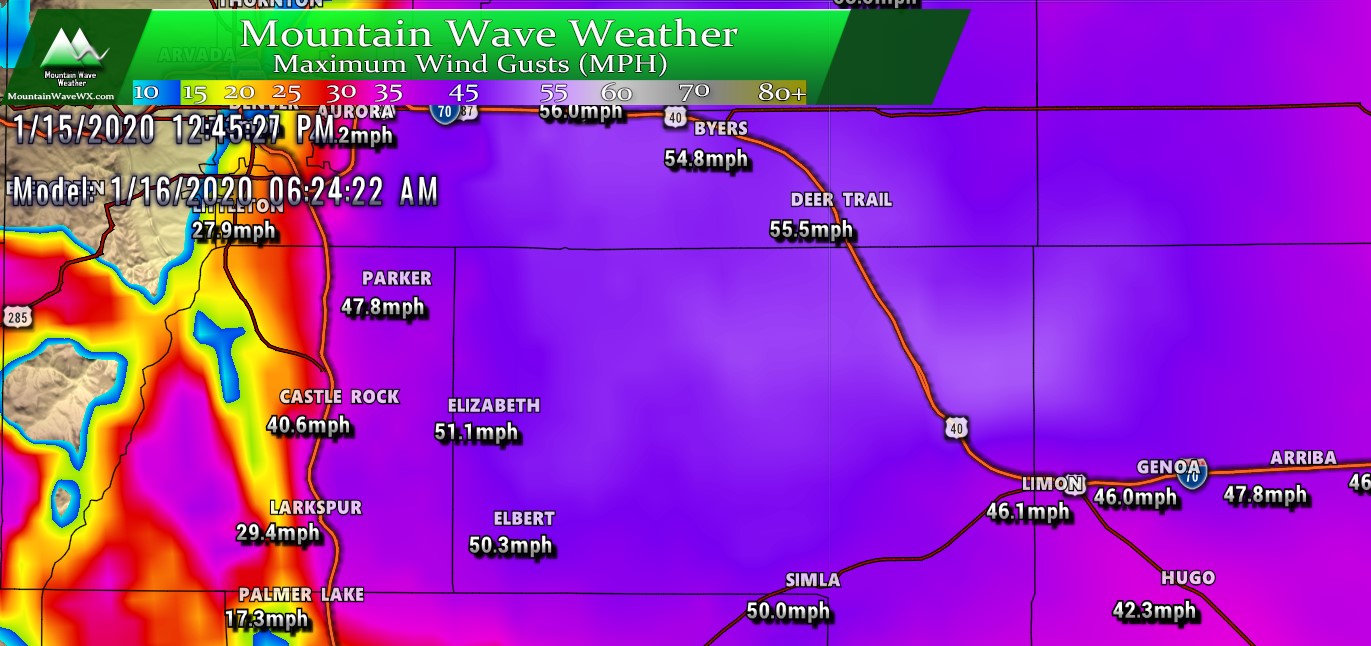
Nam3k Max Wind Gusts Thursday morning. Strongest winds look to be East of I-25
Thursday’s wind threat will be greatest East of the I-25 corridor in the early parts of the day. Models currently have winds backing off through the evening and overnight hours for most areas along the Palmer Divide, but many areas will still remain breezy.
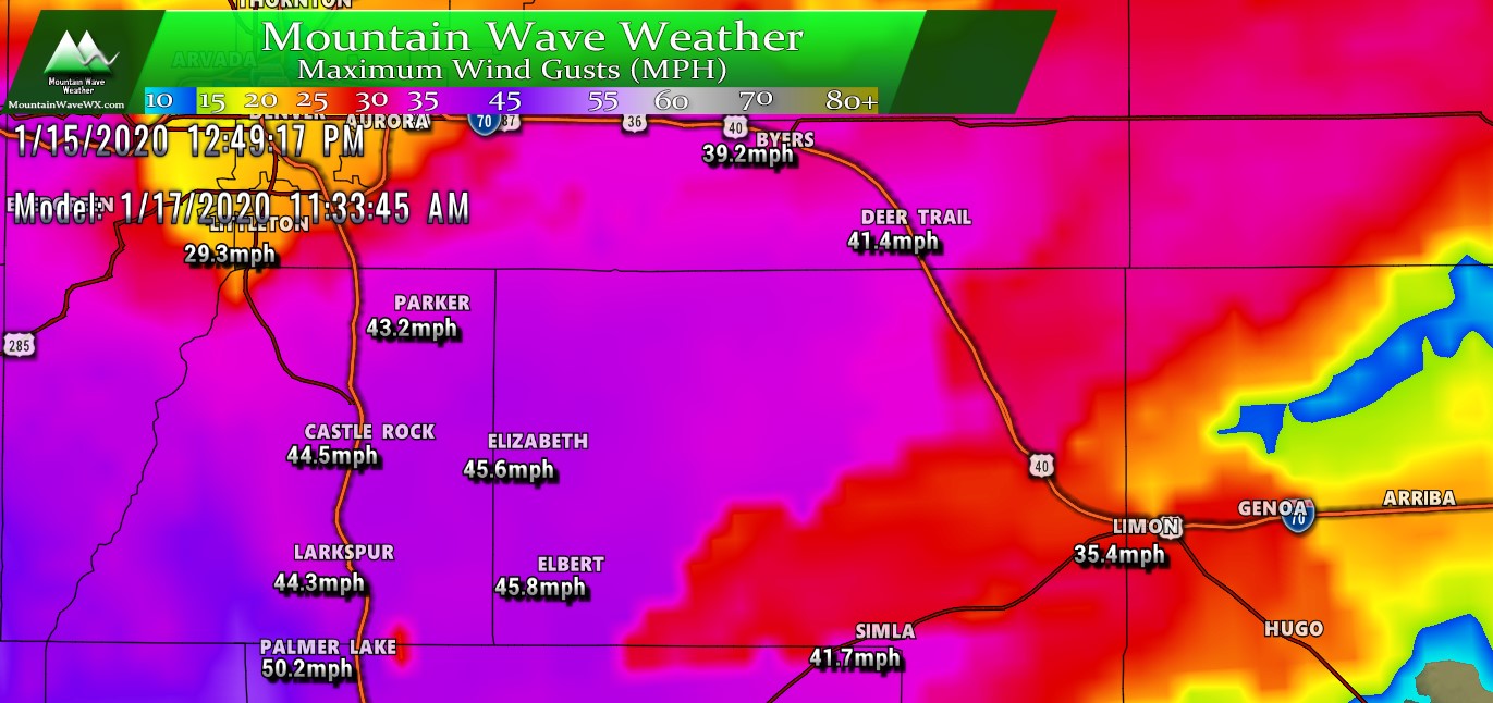
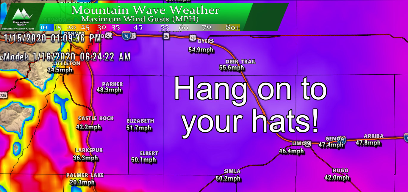
Nam3k Max Wind Gusts Friday near mid-day. Strongest winds look possible across most of the Palmer Divide and along the I-25 corridor
Friday we see more of a widespread pick up in winds across the Palmer Divide. Some areas could see wind gusts well within the 45-50mph range, if you have small things that will blow around easily, probably best to get those tied down or moved inside either tonight or by tomorrow afternoon depending on where you live. Friday will be a bumpy day for a lot of areas.
With this pattern I would expect to remain relatively warm for this time of year in terms of temperatures (slightly above average.) Model guidance shows a lot of upper 40’s to low 50’s for the next several days and that seems pretty spot on with what I’d expect. Unfortunately, with the wind cranking it probably won’t feel as pleasant as the thermometer shows.
One Final Note
I made the model image below small on purpose. I want to warn you, clicking on it and viewing it full size could potentially depress some people… depending on whether you’re a snow lover or not. You’ve been warned!
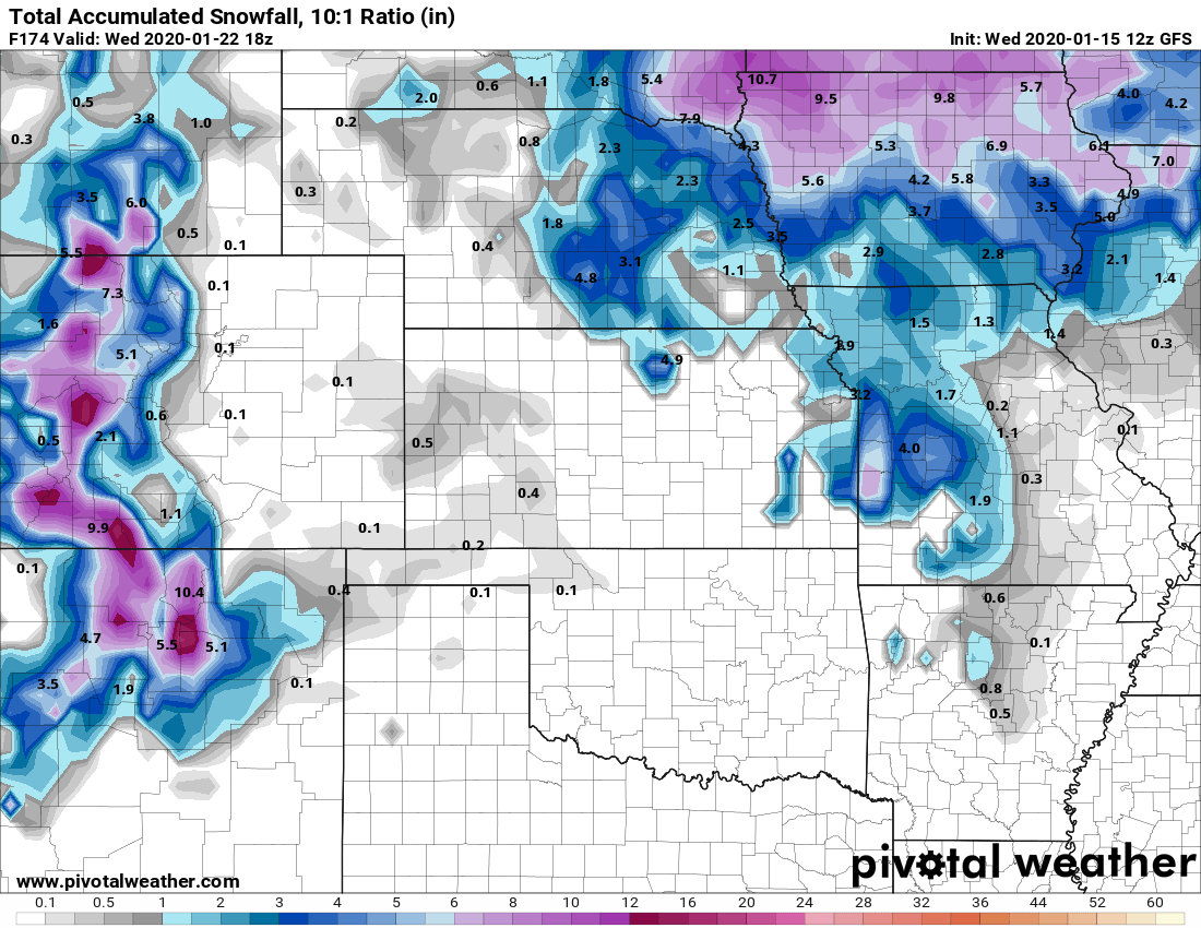
GFS predicted total snowfall accumulation over next 7 days
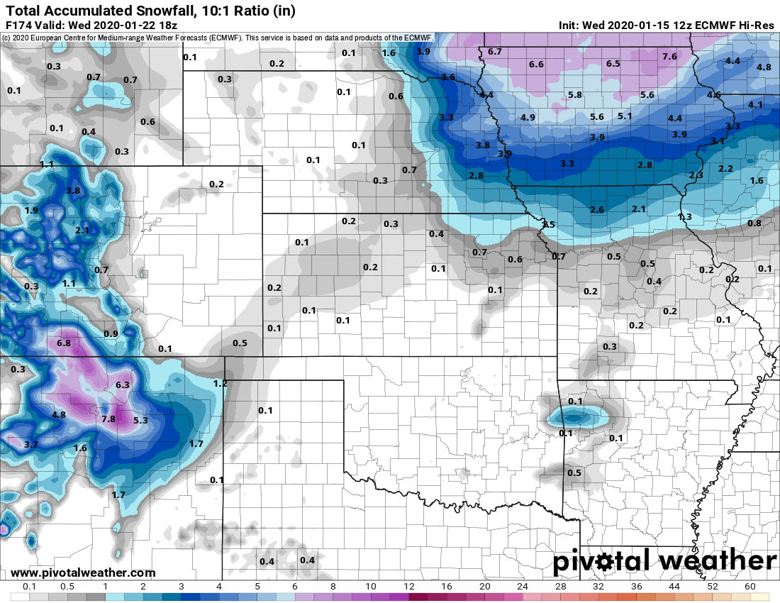
Euro Hi_res predicted total snowfall accumulation over next 7 days
GFS and Euro are what we have for the next 7-10 days and both are in strong agreement that Eastern Colorado sees little to no snow accumulation during this time period. Is it possible a little storm sneaks in and brings a shot of snow? Absolutely! But it looks quite unlikely, any storms that move through will only be able to push light showers that somehow make it over the divide in our westerly flow.
December, January and February are no strangers to bouts of dry weather. We see it all the time, our main snow season is in spring so being dry this time of year doesn’t concern me too much unless we’ve had a dry fall… which we didn’t. For now enjoy the warmer temperatures and try not to get blown away. The wind looks to be around for awhile.
Have a great Wednesday!
Thank you again for all the positive comments and feedback the past few days! If you want to sign up to be a MountainWave Weather Premium Member you can do so here!
Peak members: I will have a more detailed/technical discussion up on this weather pattern and what makes it tick in the near future, stay tuned!
