Livestream
If you missed the livestream I shot on 11/23/2019 you can see it below! I talk a lot about the general big picture of weather across Colorado and the U.S. for the upcoming busy travel week!
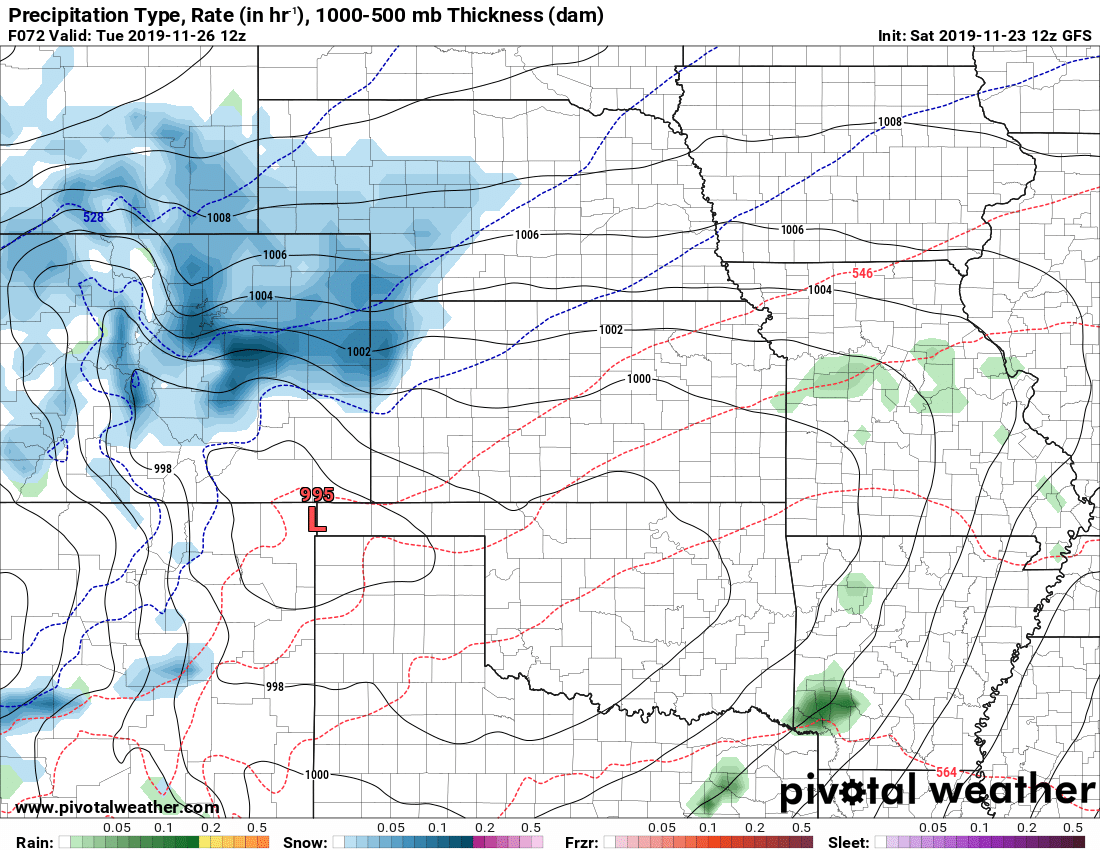
Something’s Brewing
If you caught the livestream above, take special notice of the models I showed for snowfall. As I watched the video myself even I caught the bit of surprise in my voice as I saw some of the model runs in regards to snow for the Monday/Tuesday storm. The morning models have definitely begun to take this storm a bit more seriously…
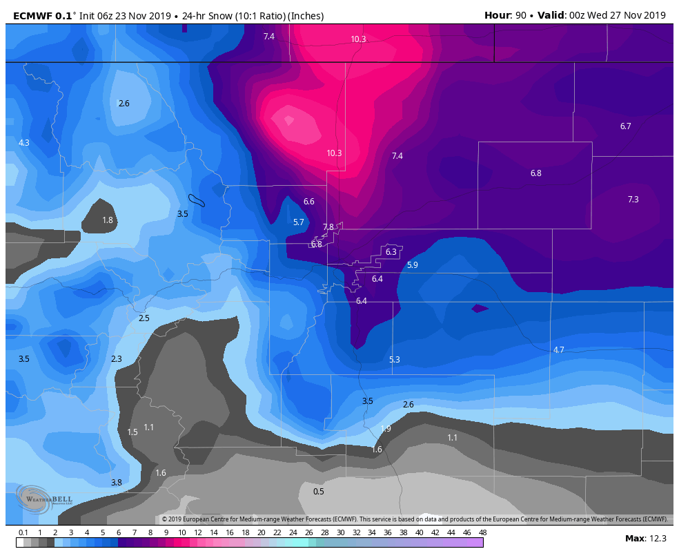
Euro 24hr snowfall totals through Tuesday PM
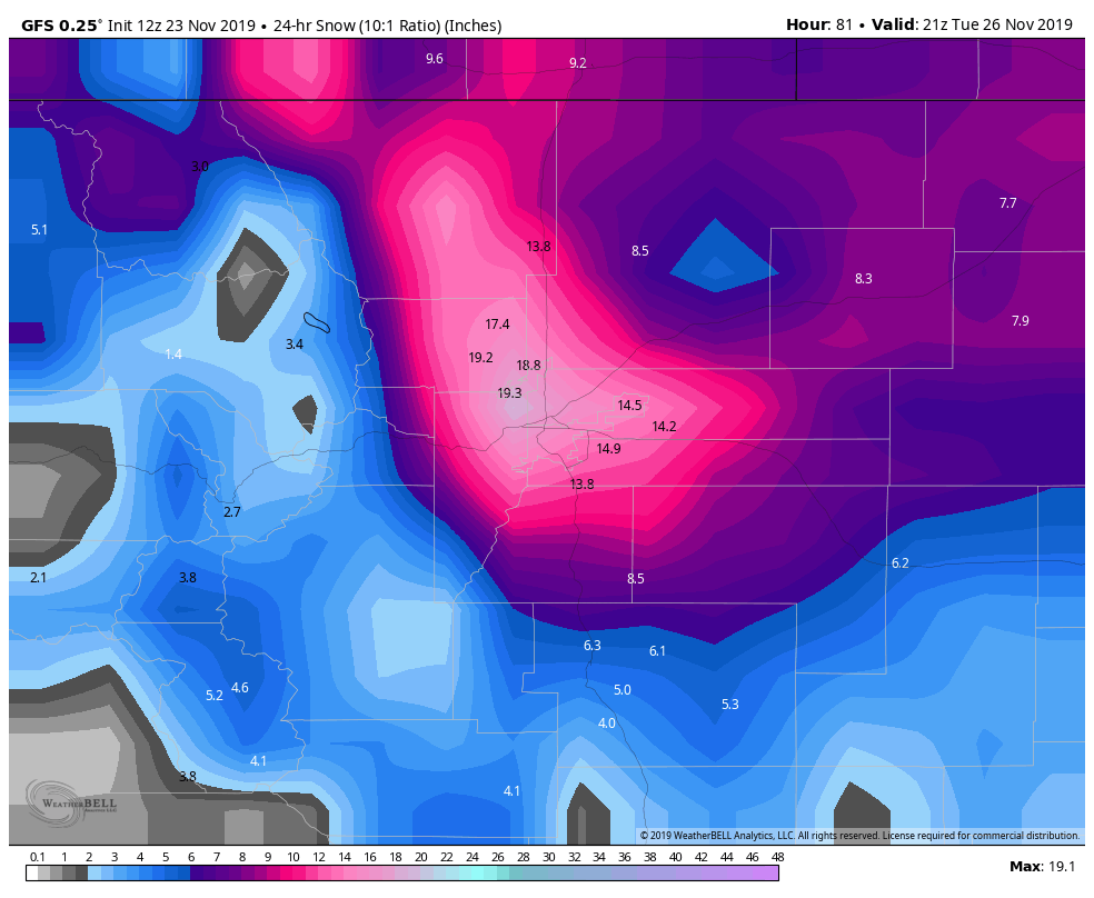
GFS 24hr snowfall totals through Tuesday PM
These are the only two models in range, but the fact that they are both forecasting higher snowfall totals gives us a clue that this storm bears close watching over the next 24-48 hours. We should begin to see more higher resolution models come into range by Sunday… if they show solutions like this it gives us more confidence in this storm.
Right now I’d say confidence is still in the low range as to whether we actually see these kinds of snow totals.
The Need-to-Knows of This Storm System As of Right Now
Uncertainty is high so please make sure you’re getting forecasts from a trustworthy source over the coming days. Be able to tell the hype from the not-hype. This storm will evolve a lot over the next 24-48 hours and there’s still a lot we don’t know.
- What We Know
- The timing of the storm looks to be between late Monday (evening or overnight not certain yet) and Tuesday PM
- Northeastern Colorado including Denver, Northern Palmer Divide and Plains look to see *SOME* sort of impact from this storm
- Model consistency is been on areas North (Northwest and Northeast) of Denver to see the highest snowfall impact
- What We Don’t Know
- Who sees how much snow… it’s simply too early folks
- Storm track; this means everything and is the difference between seeing lots of snow or nothing at all… that’s Colorado!
- Specific impacts; no clue whether airport sees impacts. Not yet sure if/how bad roads will get and what areas see the worst
So what’s the point of forecasting if we don’t know those things? The point at this time is to communicate to the public that something is coming and it may or may not be significant… additionally to communicate to watch the forecast closely and expect impacts to hit late Monday into Tuesday. That’s the weather game folks, we don’t have specifics yet but we can communicate this stuff so the public gets ready in case this does impact our area heavily.
Here’s What to Do If Travelling or Have Plans During This Timeframe
We’ve seen a significant jump up on the models this morning but I need to see one or two more runs of the same before I throw too much weight behind this storm system. With that in mind and all the uncertainty; here’s the best advice on what to do…
- Watch the forecast closely over the next few days
- Be able to sort through “hype” forecasts… I imagine there’s going to be a lot of that coming out today and tomorrow
- Ask questions! I’m always happy to answer specific weather questions but remember it’s the weekend and I’ll be away from the computer here and there. Have patience, I’ll get back to you!
***I do not advise making any changes to travel plans at this point. It’s simply too early, just keep an eye on the forecast!***
Summary
Looks like we got a storm brewing, I’m still a bit hesitant on it as I could easily see the main energy staying North of Denver on this one. If you follow me you know I tend to side conservative on storm systems in general until I see solid data… that’s where I am with this storm.
The next day or two will give us good insight on whether we need to start getting excited about this one or not. Stay tuned!

Tsk. We are watching this closely since we are traveling by car to Santa Fe. We are trying to decide whether to leave early Monday morning or keep plan for Wednesday Tks for you weather insight
Monday early is your best bet. Wednesday may be ok too as this storm is scheduled to move out Tuesday afternoon, but if it slows down or stalls it could linger into Wednesday. Worth keeping an eye on, we’re going to get a lot better detail with this storm on Sunday morning.