It’s Spring in Colorado and that means there’s always potential for power spring storm systems? There’s one in particular that has our eye next week that I’m watching very closely. I’ve accumulated a lot of the initial data we are looking at and compiled it for our site supporters in this article – this should give you a good idea of what I’m seeing now, what I’ll be looking for and a rough idea of what may happen next week!
Next Week’s Spring Storm System – A dud or something to watch?
[s2If !current_user_can(access_s2member_level0)]
There’s no better time to become a Mountain Wave Weather site supporter! You’ll get access to premium articles like this one, more weather discussion, long range forecasts and reviews – and support this site and what we do! Click the image below to sign up today!

[/s2If]
[s2If current_user_can(access_s2member_level1)]
Let’s Look at Some Models!
Being this far out and since the deterministic models are still bouncing around a bit too much, I’ve gone back to our old friend the ensembles for both the Euro and GFS to try and get a “smoothed” out look without all the outlier data. This gives us a nice average of what models are expecting without too much of the crazy stuff thrown into the data set.
Storm Evolution
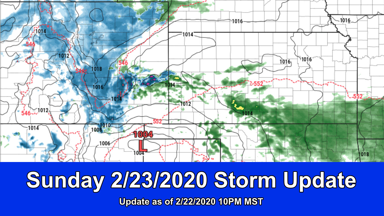
Both models agree relatively well on the placement and evolution of this storm system as it moves out of the Pacific Northwest, across the intermountain West and into Colorado. the track takes it over Western Colorado while diving Southwards and eventually ending up in that prime four-corners area we like to see larger storms set up at!
Euro Ensemble
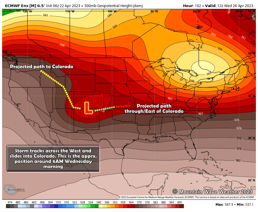 Shown above is the 500mb upper level air pattern that allows us to see troughs and ridges in the middle and upper part of the atmosphere. These are important because they can show you the path of a storm, how strong it gets, where it is at any point in its evolution and potentially where it goes/how it strengthens or weakens and when or where. Being 4-5 days out with this storm, we have to take exact numbers on strength, evolution and positioning with a grain of salt – instead just focus on the larger scale pattern.
The Euro shows the storm moving out of the Northwest and diving into Colorado through mainly late Monday and into Tuesday. By Wednesday morning we see the trough as above, over roughly Southwest to South Central Colorado. The anticipated path according to this model brings it from the four corners area, right along the Colorado/New Mexico border and out into Kansas. It has a very, very slight Northward turn as it exits the state and moves into Kansas – where this storm turns and how it turns will be critical along with its overall speed – to exactly what we see out of this storm. The track shown below is fairly favorable for larger amounts of moisture in Eastern Colorado.
GFS Ensemble
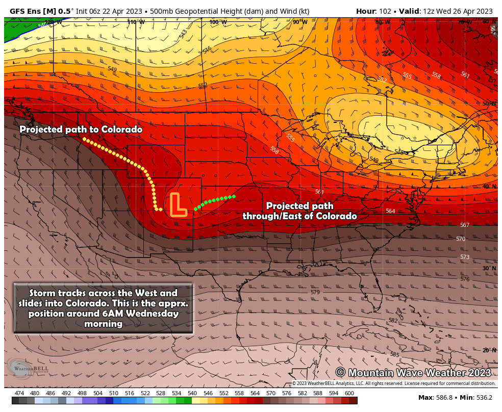 Notice the similarities in track with the GFS ensemble above and the Euro? Pretty decent agreement overall, the differences show a bit further into the storm with positioning, strength and track. Not a huge difference so not going to take too much time on this, but enough to keep an eye on. The GFS Ensemble is a bit more progressive with the low through Colorado (it’s moving a bit faster) and tends to want to hook it a bit more Northwards as it moves through Eastern Colorado and into Kansas. This is a more optimal track for larger amounts of moisture along Eastern Colorado.
Snow or Rain?
That’s the million dollar question with this storm, here’s a look at expected temperatures late Tuesday night and into Wednesday morning…
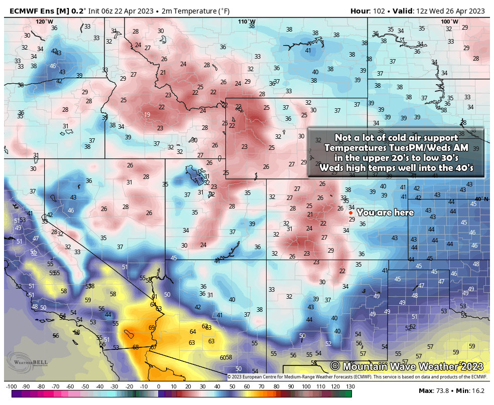 Temperatures are marginal at best for lots of snow accumulation. This snapshot from Wednesday morning shows temperatures around 33-34 in Denver with upper 20’s along the Palmer Divide. This will be a huge factor in determining who gets snow and how much – likely elevation is going to play a large part due to the differences in temperatures.
One thing we are fairly confident on… someone’s going to get a ton of moisture either way – whether that is us or someone North of us or South of us is still to be determined over the next few days.
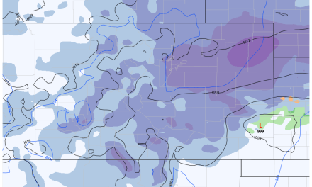
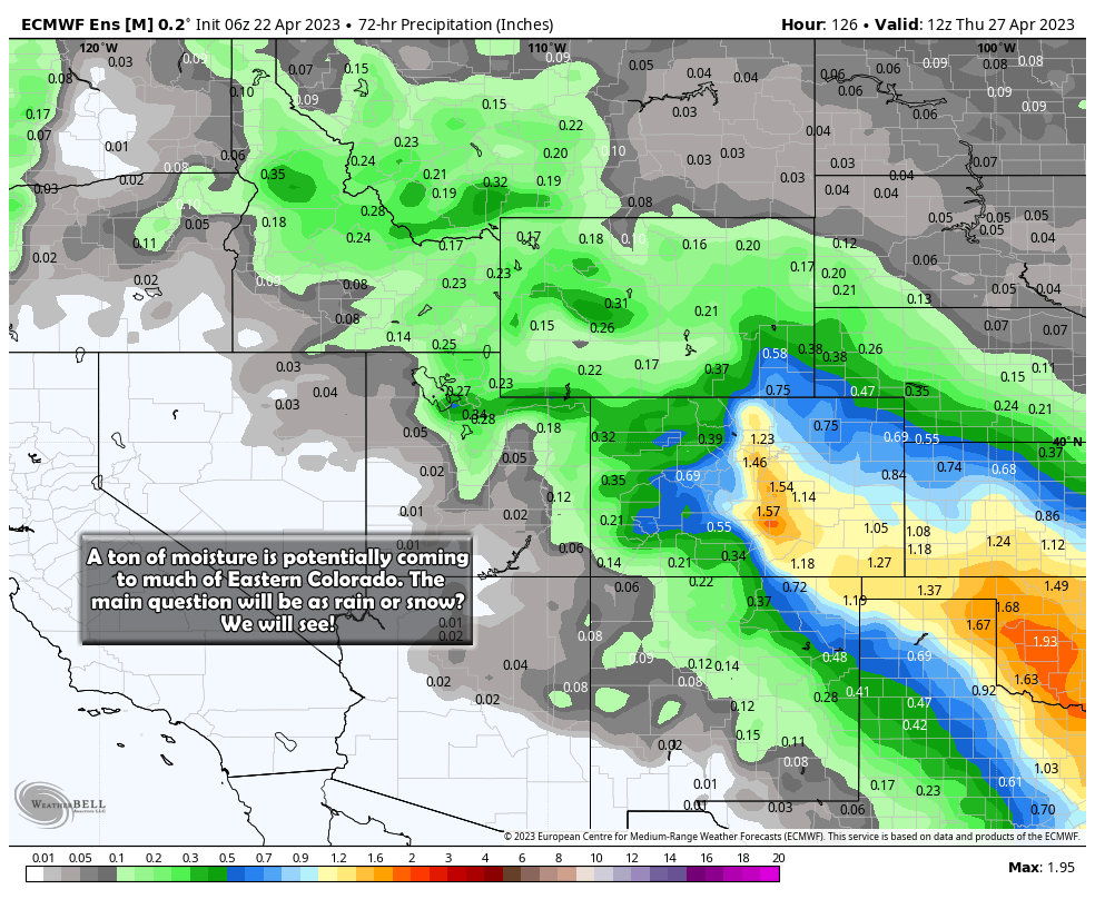 This graphic shows the QPF or quantitative precipitation forecast meaning how much water is expected to come out of the sky (without care of as snow or rain.) You can see that this storm will likely tap into a moisture source from the Gulf and pull a lot of that moisture into Colorado (if this model verfies.) 1.5 inches of precipitation for the Palmer Divide, which if all fell as snow in a 10:1 ratio would equal 15 inches of snow. That being said, this won’t all fall as snow so don’t get too excited yet… but there are indications that snow is indeed in the playbook for this one.
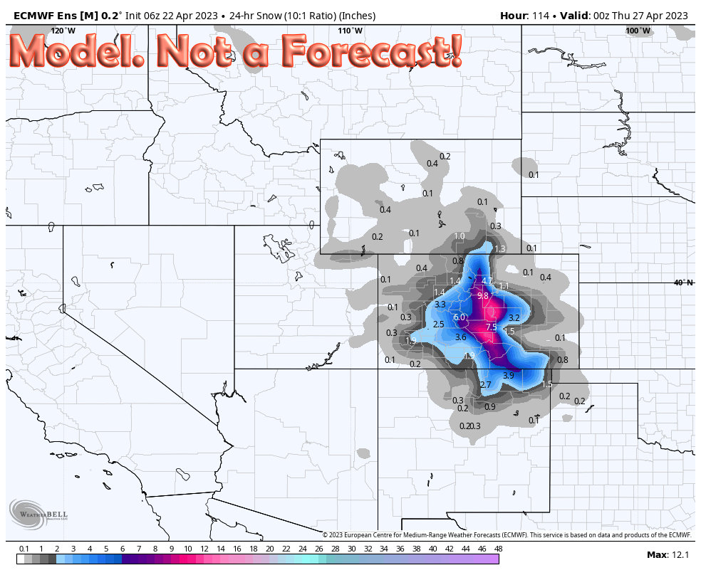
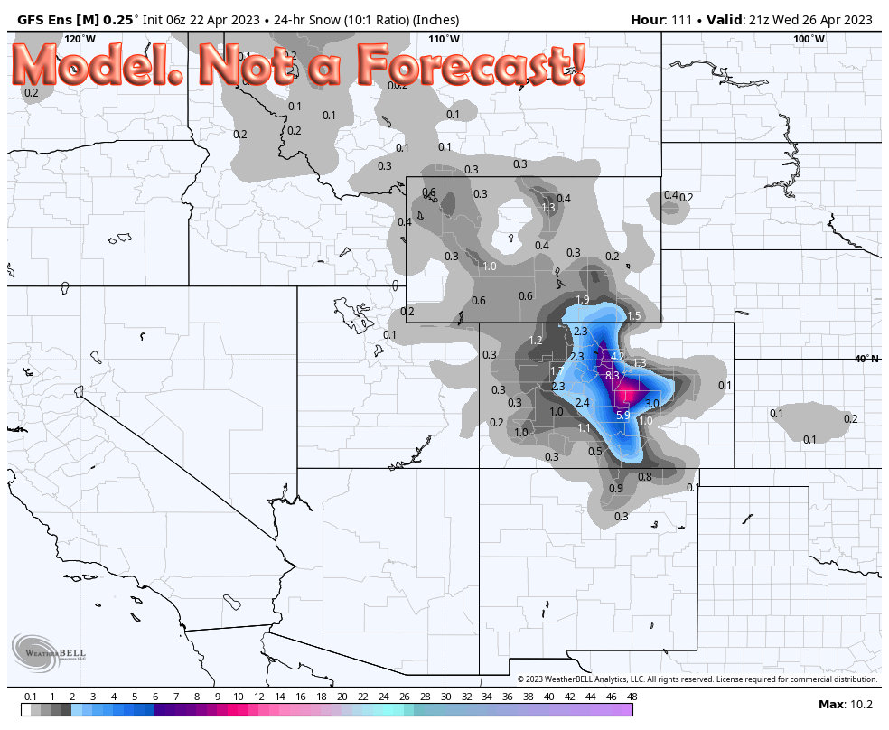
Say it Snows… How Much Would We Be Looking At?
Here’s your disclaimer before I show model data: these are models, not a forecast! There’s still a lot of time for this to change so don’t get too hung up on specific numbers and times… just look at the patterns (which I’ll describe below the graphics…)
Euro Ensemble
GFS Ensemble
 Analysis
Here’s the major things to note with both of these products:
- High snow amounts are possible, especially along higher elevation areas. This means in future forecasts we’ll want to keep a close eye on the Front Range Foothills, mountains along the Continental Divide and the Palmer Divide
- Temperatures are going to play a huge role – any temperature swing warmer or colder (even by a couple of degrees) will make a huge difference of how much snow these areas see
- Storm track is optimal for a heavy snow/ very wet spring storm across Eastern colorado
Things Working Against This Storm
There are a few things we will have to watch closely in the evolution of the forecast for the next few days:
- The storm appears to weaken as it swings through Colorado – this would mean less snow and moisture overall
- There’s not a stout cold front with this storm, this makes temperatures a concern for generating and accumulating some of those higher predicted snowfall amounts
- Timing: GFS moves the storm through quicker while Euro has it slower – a storm system that lingers will bring more moisture to the area
- Do we get a severe weather outbreak ahead of the storm system that saps a lot of that moisture out of the air before it comes to Colorado? –this can happen in Springtime in Colorado and completely destroy a weather forecast…
[/s2If]
Summary
So this storm is looking interesting and will need some close watching over the next several days. I’ll be in full “forecast” mode for this one starting with a post late Sunday night. Be sure to check back then for additional details and as needed on Monday and Tuesday.
