Before we move into the fun stuff… do remember there is a chance for light showers across the area this afternoon and even a tiny bit of snow for higher elevations.
If you’re driving through the mountains and especially those to the Southwest, plan on snow to create travel delays and impacts.
A More Active Period of Weather Coming?
Lots of comments, questions and concerns about the midweek snow storm coming up… and rightfully so. This thing has been getting a lot of media attention, but the most interesting part is that it may just be one in several weather disturbances that could impact our weather in the near future. The overall weather pattern is shifting as we move into the second half of January and that means we may see a period of storminess/unsettledness for awhile in Colorado. We will have to see how this evolves, but I for one am excited about the increased chances of moisture!
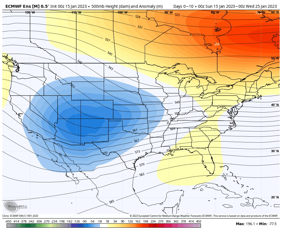
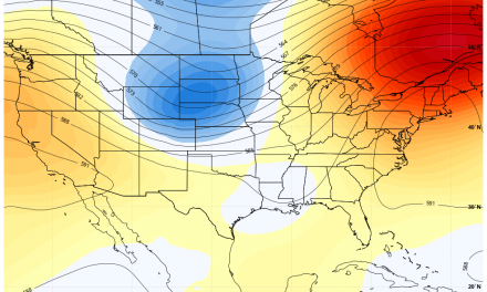
Euro ensemble shows a trend towards lower pressure for the next 10 days over the intermountain west. During a setup like this, we would expect to see a more active storm track across Colorado, but exact details on any specific storm would need to be handles on a case-to-case basis.
Midweek Storm Messaging
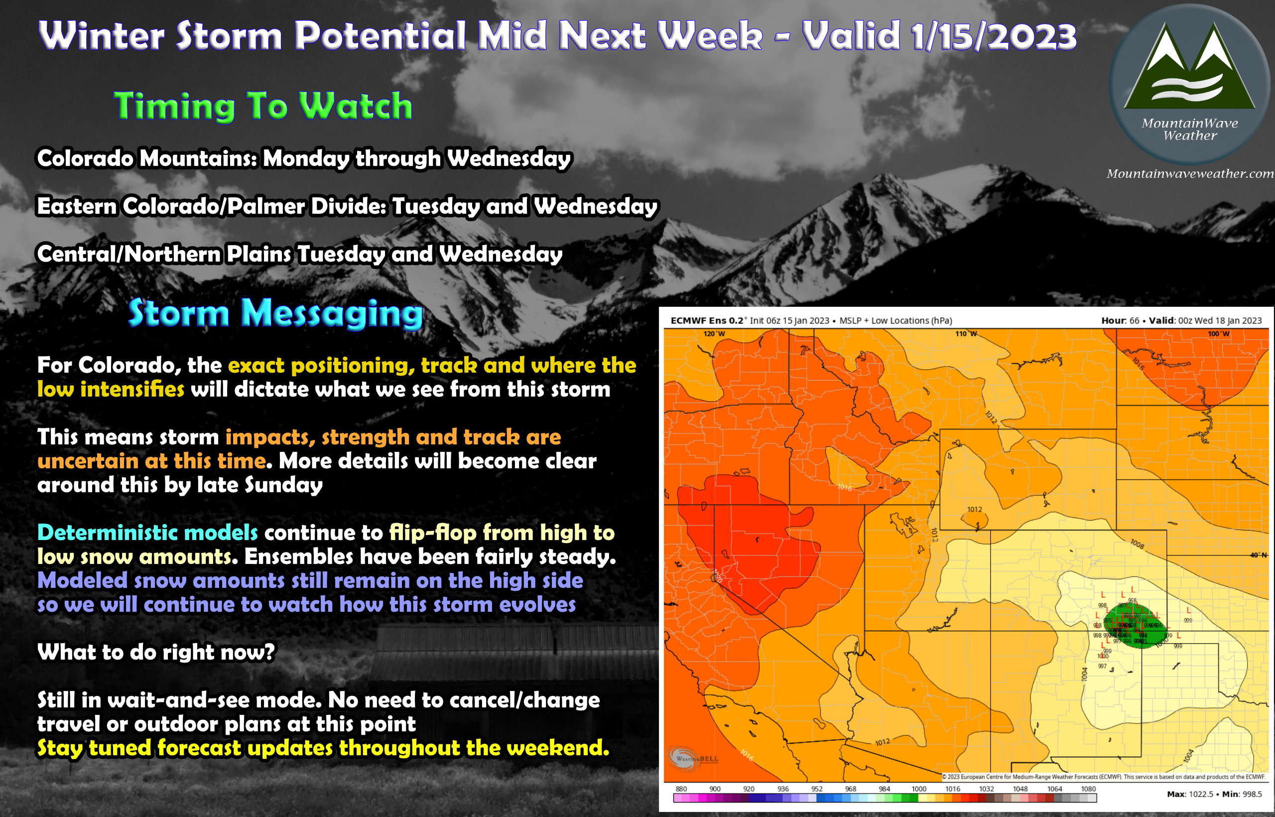 Still have lots of questions to answer about this storm, but as we move model by model we start to see a bit more clarity.
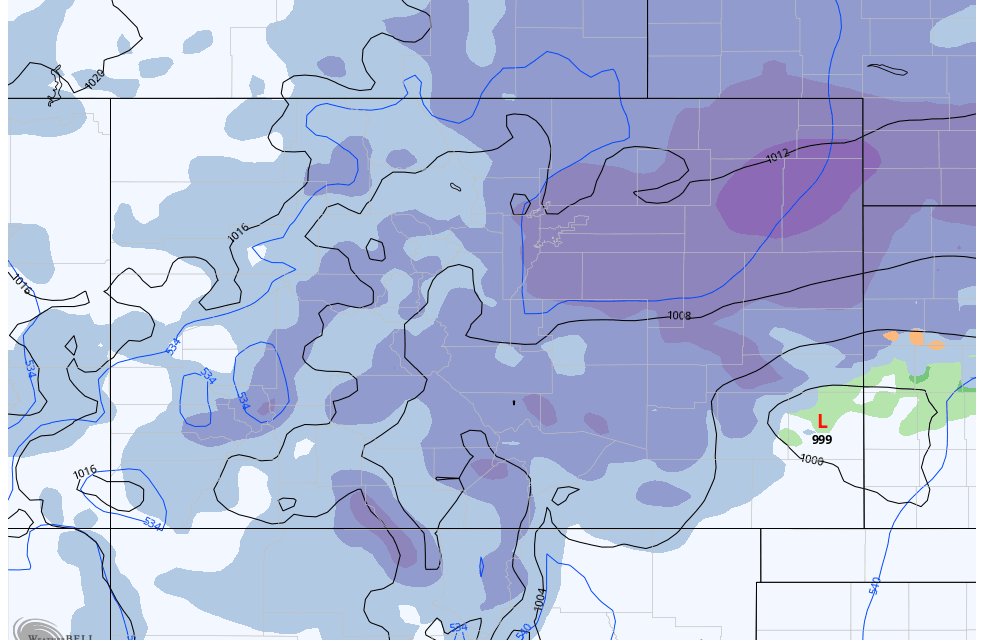
- Storm positioning, track and intensity is still a bit fuzzy, but this morning’s details point to many setup spots that would be favorable for a decent snow event along the front range
- Notice the Low positions on the ensemble graphic above are beginning to tighten up around the Southeastern Colorado point
- We are still seeing a decent amount of flip flop in our deterministic models with ensembles showing less bouncing but a general trend upwards in snow amounts along the front range
- This means confidence in any specific snowfall amounts is about low to low/medium… but it is slightly higher than yesterday (would be considered low to very low)
- Still lots of data coming and lots of time for this storm to evolve
- We are in a “wait-and-see” holding pattern on this storm right now. No plans need to cancelled or changed at this point nor does travel
I do understand that due to the media attention, people will start to wind up a bit about this storm so my additional thoughts are:
- If you need groceries, get them today or early Monday… don’t wait for the rush
- You won’t need many days of food, this storm moves in Tuesday and out by late Wednesday…meaning you wont’ be trapped in your house for a long enough period of time to need to have enough supplies to feed a small army
- Rural areas? Stock up on some supplies, as you know roads out in these areas are lower priority and more difficult to keep clear.
Main messaging: This storm does not look like a major/city crippling blizzard at this time. But, it does have the POTENTIAL to be a GOOD SIZED STORM that creates MODERATE OR GREATER IMPACTS
Prepare as such!
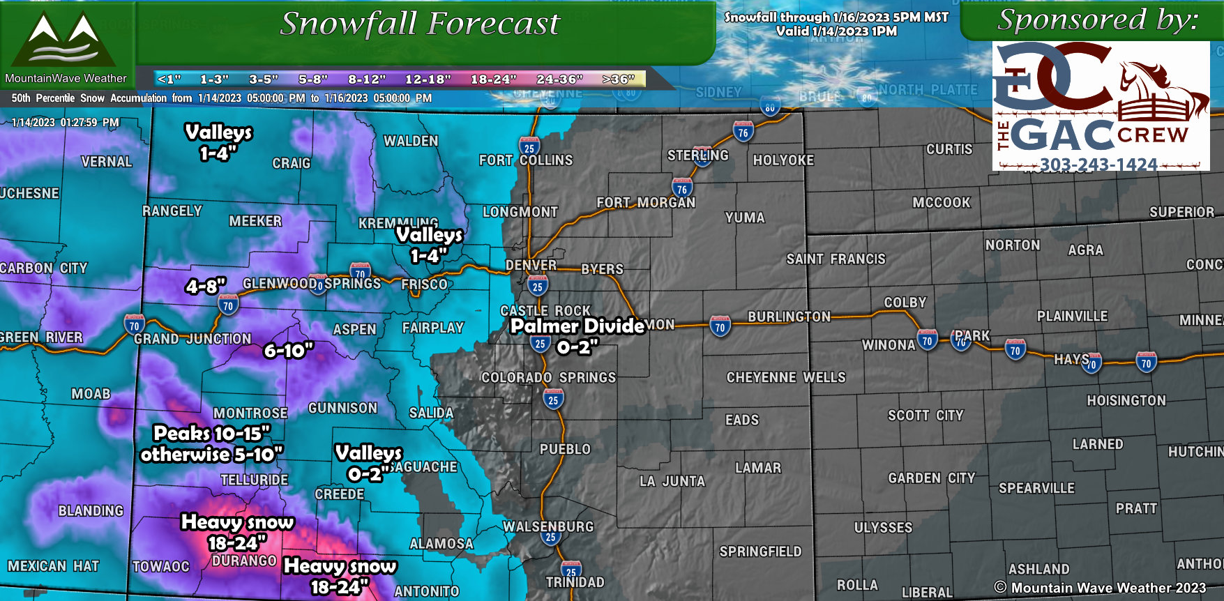
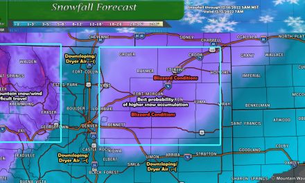
Slicing and Dicing Tuesday/Wednesday’s Snow Storm
To show the models in action and how we are looking at trends and bouncing (flip flop) here’s the best models we have at this time for this time range for a storm. I’ve included graphics below that show accumulated snowfall expected between each model run. This can allow us to spot the trend better as to what the models have been thinking between each run… the more bouncing we see the lower confidence we have in that particular model’s handling on the storm.
NOTE: THESE ARE MODELS… NOT FORECASTS. As such, treat the specific numbers with huge grain of salt (honestly I’d ignore them for now.) I put some handy-dandy arrows on the side of each model graphic to illustrate what the snowfall accumulation trend is doing from each model run to the next. The point of this exercise is to look at the trend…
GFS Deterministic
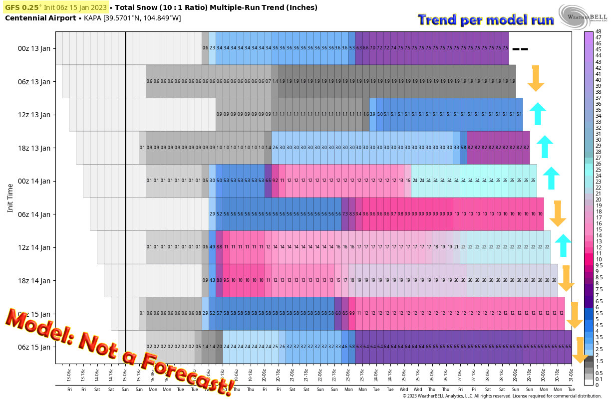
My least favorite model to look at for snow storms… it tends to have wild swings and unrealistic snowfall amounts. It is typically one of the higher end outliers especially early on in the snowfall forecast. Why use it then? It can be useful if you understand its strengths and weaknesses… I tend to to use it more for probabilistic and trend forecasting. This is the model everyone likes to post for attention because it can come out with some wild looking maps… but rarely do those high end maps materialize.
The trend with this one is not surprising, it was spitting out some ridiculously high numbers early on in realm of 2+ feet… no other models showed anywhere near this so it could be considered an outlier. Also notice in the last 3 consecutive model runs, there’s been a fairly strong downtrend closer towards what other models are predicting. This happens a lot with this model!
GFS Ensemble
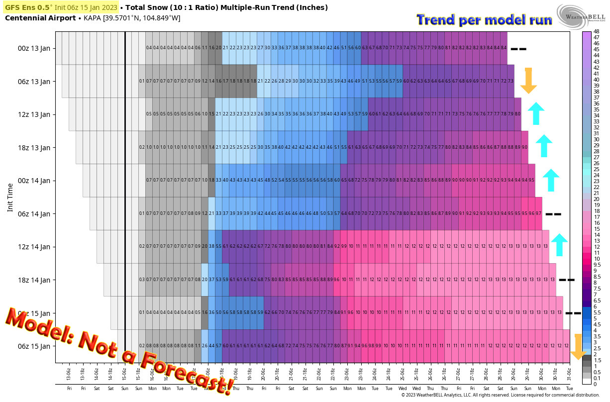 The ensemble version of the GFS tends to overdo things a bit as well… but since an ensemble is an entire suite of model runs blended together – this product tends to smooth out some of the wild swings seen early on from the deterministic product. Notice here how the overall trend is upwards or flat, but we don’t see crazy 24″+ numbers like the GFS Deterministic shown earlier.
The Euro Deterministic
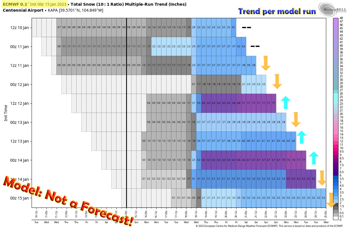 The Euro model in general is one of the more reliable and tends to do better on snowfall forecasting with a bit more range than the GFS. Here, we see the trend on the deterministic continues bouncing a bit up and down, which tells us this model is still a bit uncertain on what this storm will do. It’s our jobs as meteorologists to look at this and communicate that uncertainty to the public.
For this model, the trend is fairly even with 5 runs going down in snowfall, 3 going up and 2 roughly steady. There is no good long term trend here, so this is just a “keep an eye on it” model and see how it evolves its thinking throughout the day Sunday and Monday.
The Euro Ensemble
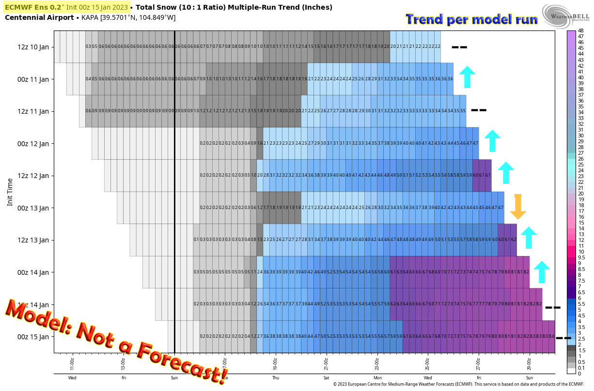 Now here’s where it gets interesting, the Euro ensemble, much like the GFS ensemble is good at smoothing out the bounces found on the deterministic and showing better trends (sometimes.) At the very least, if we see bouncing on both ensembles and deterministic we know there is very high uncertainty with any forecast for specific snowfall amounts.
The Euro’s ensemble members have shown a steady and verifiable increase in predicted snowfall amounts; a nice uptrend. As I tend to put more weight on the Euro models than the GFS this would give me slightly more confidence that we see more than just a few inches of snow. But it is early yet, more data needs to come in to see if we verify that trend, see it flatten out or if we see it reverse.
Hopefully this information gives everyone a bit of insight to my forecasting process (this is only one of about 10-15 things I look at to create a forecast, but it has weight) and why I’m not a huge fan of the GFS and people posting it for shock value. It just doesn’t pan out…
Summary
Messaging is still the same with this storm:
- Expecting impacts Tuesday/Wednesday
- Still lots of uncertainty on track/intensity/specific timing
- Snowfall amounts are still low to medium confidence at this point in time
- Potential for decent snowfall accumulation and travel impacts Tuesday and Wednesday along the front range
I’ll have more details up possibly late tonight or early Monday morning. Have a great Sunday!
