Current Winter Weather Highlights
 Winter Storm Watch
In effect from 6PM Tuesday April 25 through 12PM Wednesday April 26
Includes the Front Range Mountains; Front Range Foothills- West of Fort Collins, Loveland and Denver; the Palmer Divide - locations above 6,000 feet in elevation; Northern El Paso County, Monument Ridge and Rampart Range; Pikes Peak Region West of Colorado Springs
* WHAT...Heavy snow possible. Total snow accumulations of 5 to 10
inches possible.
* WHEN...From Tuesday evening through Wednesday morning. Heaviest
snow expected Tuesday night into early Wednesday morning.
* IMPACTS...Travel may become very difficult due to heavy snowfall
on roadways. Plan on slippery road conditions. The hazardous
conditions could impact the Tuesday evening and Wednesday morning
commutes.
Storm Analysis
We've had our eyes on this storm for a good couple of days now - and we do see many indications that this could be a large and impactful storm (FOR SOME PEOPLE...)
We'll get into that in a minute, but here's the expected storm track - you'll see that this is a pretty favorable track for heavy precipitation... regardless of what type it falls as.
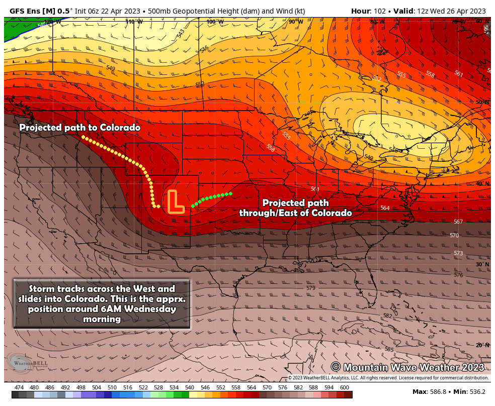 Storms like this are often called a "four corners" or "albuquerque low" because the storm tracks into the four corners region and moves across Southern Colorado/Northern New Mexico. Storms like this often tap into extensive gulf moisture and pull it towards Colorado. Additionally, if the storm tracks right it pushes that moisture up against the higher terrain in Colorado, causing it condense and precipitate. This is called upslope.
Make no mistake, storms like this have the potential for long duration and strong upslope flow with them. This all equals a ton of moisture squeezed out as rain or snow depending on the temperatures.
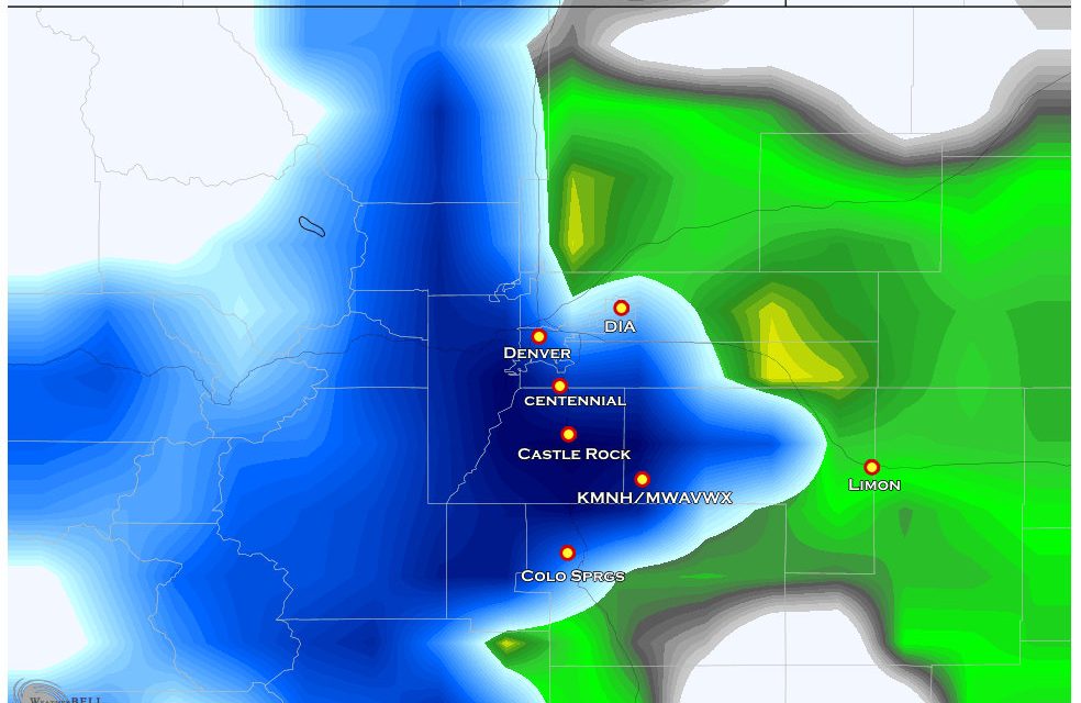
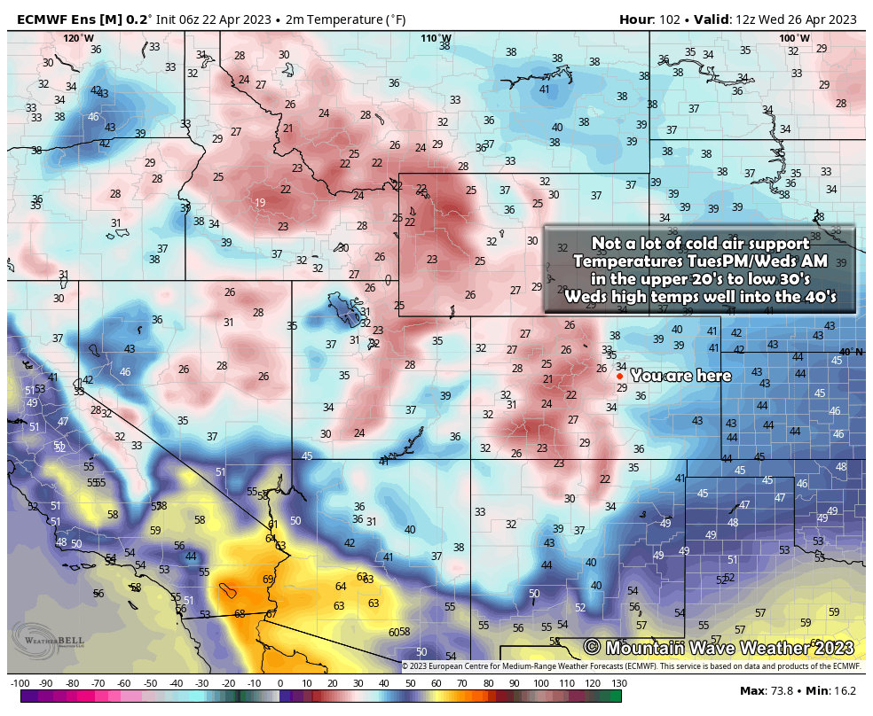
Speaking of temperatures, they will be marginal for snow - meaning higher elevations with colder air will have the best shot at accumulating heavy snow.
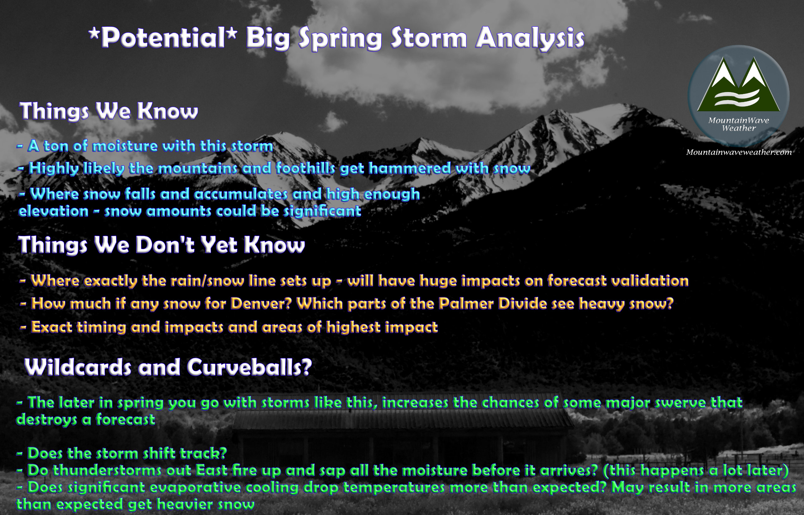
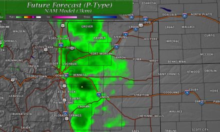
 One might look at the graphic above and say, "well that does it then - this storm will bust in terms of snow and most areas just see a heavy/soaking rain." Not so fast! Make sure to read the "wild-cards" section towards the bottom of the article for more info on why I think some areas will see very heavy snow (and some areas may overperform snowfall.)
For now, my messaging with this storm remains the same: there is a higher than average chance this storm will have heavy and accumulating snow resulting in moderate to significant impacts to travel and those with ag interests.
Make sure you're prepared... if nothing happens it's a minor inconvenience - but there's a high enough chance this storm will cause some pretty big issues for localized areas and it's better to be prepared and not need it vs not prepared and need it.
Snowfall Forecast
For right now I've got the Palmer Divide forecast and then a more general look at Colorado... until we get better model info I'm not going to deep dive into specific spots in Colorado outside of the Palmer Divide. It's simply just a bit too early for fine details on a lot of these areas.
Keep that in mind as well, this is a preliminary forecast and WILL change in the next 24-48 hours. A forecast is not a static thing, it evolves and changes based on model data, observations and the knowledge of the person putting together the forecast.
Palmer Divide
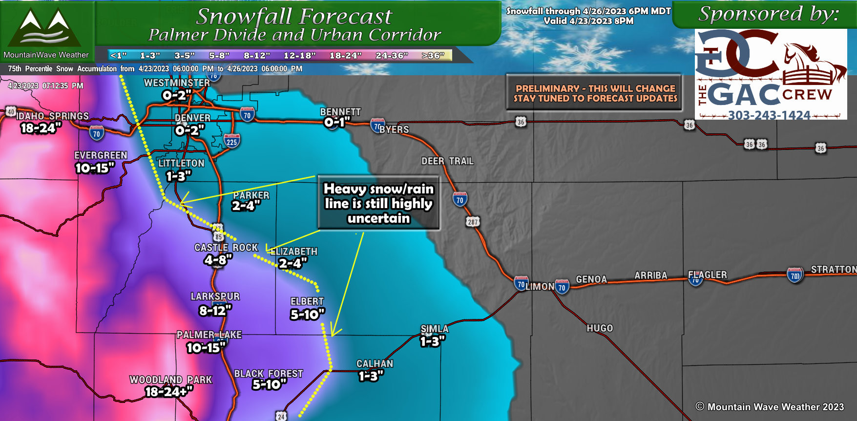
I've blended together slightly higher snowfall totals for some of the higher elevations of the Palmer Divide. I'm leaning on this at the moment as often these storms can come in a bit colder than anticipated - this would mean some of those fringe areas behind the rain/snow line would see higher amounts.
Rest of Colorado
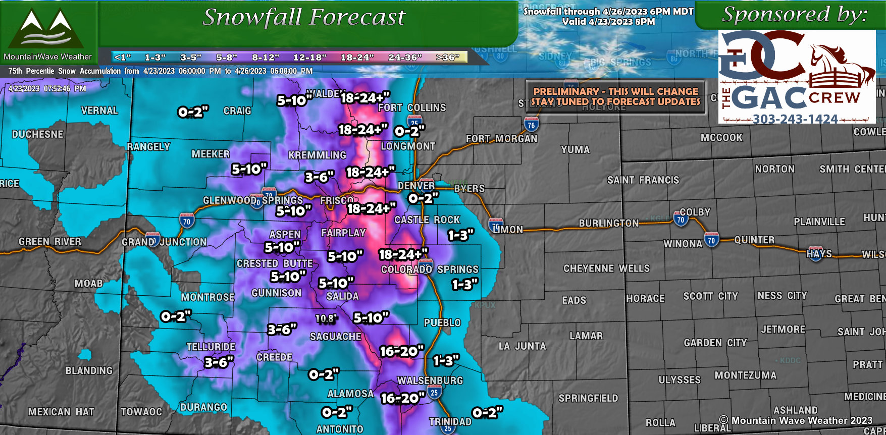
Zooming out at the state level, you can see where the heaviest snow is most likely.
In all honesty, snowfall accumulation between 1-3 feet is not out of the question for these areas:
- Front Range Mountains/ Continental Divide Mountains
- Front Range Foothills West of Denver
- Foothills West of the Palmer Divide
- Portions of Teller County and Southwestern Douglas County (higher elevation foothills and mountains)
- Pikes Peak region West of Colorado Springs
Just like the Palmer Divide forecast above, I blended these numbers slightly higher. It is also a preliminary forecast and will evolve over the next 1-2 days so make sure to check back for updates.
The Wildcards and Curveballs
It's a spring storm this late into April... we see more debauchery out of these types of storm systems the later we get into spring. I'm sure this one will be no exception... here's a few things we'll have to keep an eye on that could either bust the forecast low or completely - or significantly overperform against the forecast...
Timing/Impacts
Not much is certain on this just yet, check back when we get a few more details but this should be enough for your planning purposes:
Highest impacts along the Palmer Divide look to be Tuesday night and into Wednesday morning.
This means the Tuesday evening commute and Wednesday morning commute are both fair game in terms of POTENTIAL significant impacts.
Again, I'll try to nail the nitty-gritty of more precise timing and impacts in the next 24-28 hours.
Summary
Main messaging is in red above; above all be prepared for a potential heavy snow and significant impact event. We will try to nail down more of the details in the coming days and be sure to forward that information as quickly and accurately as possible.

