
After the cold start we had earlier this month, it looks like April will end on an abnormally warm note. We’ve been tracking a signal in the models for the past few days that shows a very strong high pressure ridge building over Colorado to end this week.
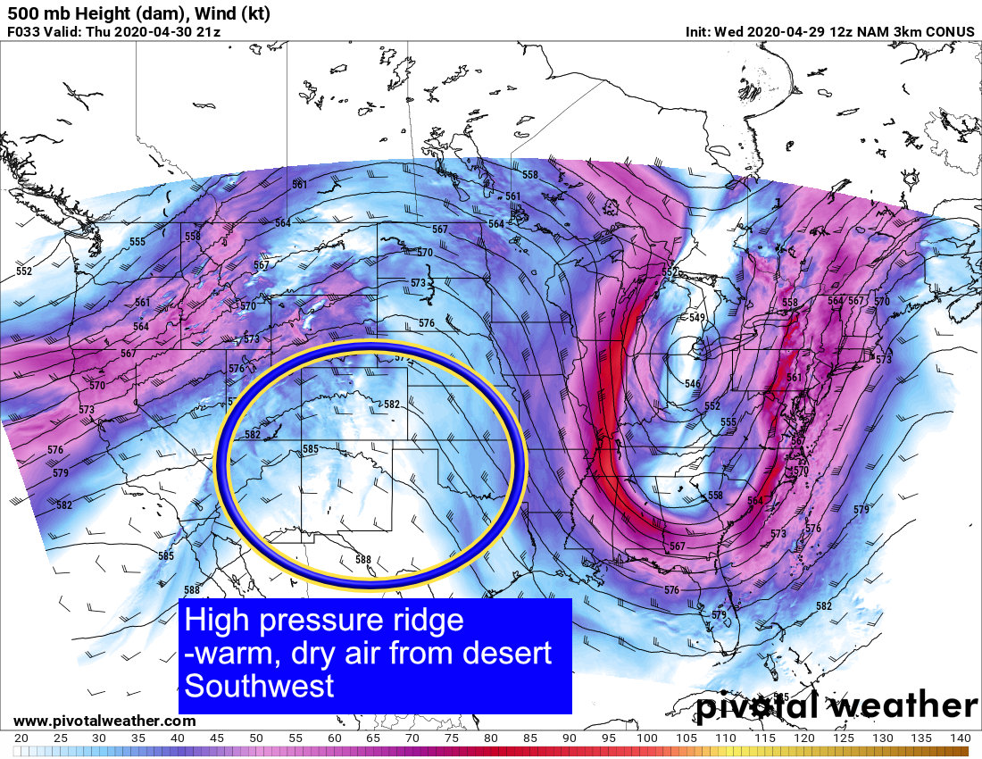
As this high pressure ridge sets up over the Southwest and Western United States, it will allow warm, dry, desert air to push into the area from areas like Arizona, Nevada and New Mexico. This means we will likely skip spring and go right into summer… at least for a couple of days this week!
Record High Temperatures in Jeopardy?
Models have backed off the heat significantly over the past few runs, but it will still be quite warm. Thursday and Friday could see many areas on the plains flirting with 90’s for the first time this year, while temperatures back to the west will be a bit more subdued… but only a little.
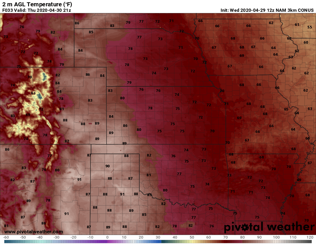
Click to view Nam3K forecast highs for Thursday 4/30/2020
Thursday is now looking like the warmest day with many areas along the I-25 corridor well into the 80’s. The exception will be the higher elevations of the Palmer Divide where upper 70’s to lower 80’s are most likely… still it’s well above normal for this time of year. Many areas in and around Denver could also see some high temperature records fall. We’ll keep an eye on what the NWS says and pass along any new records as they come in.
By Friday we remain warm but just slightly cooler for the urban corridor.
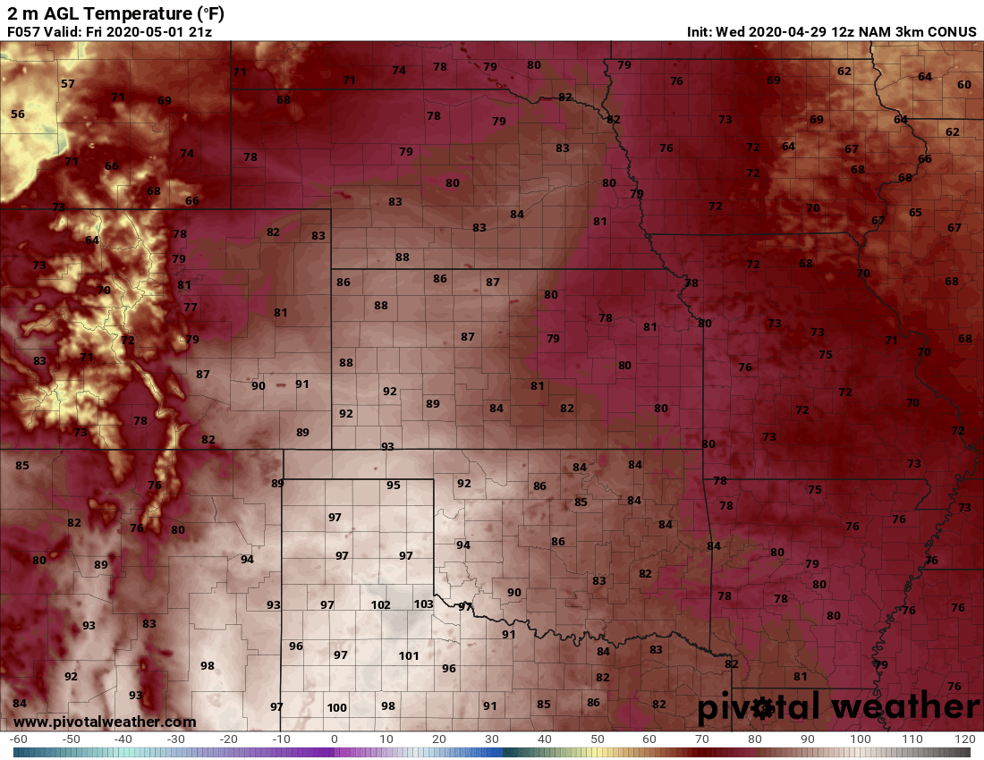
Click to view Nam3K forecast highs for Friday 5/01/2020
The warmest temperatures will sag just to the South on Friday with the hottest areas in the state being the far Eastern plains and Southeastern corner of the state. Many of those areas will see temperatures into the 90’s which is still quite warm for them this time of year.
Pattern Change by the Weekend? Severe Weather?
By Saturday a storm system starts to move across the area that will bring our temperatures back down a bit as a cold (cool) front sweeps across the area sometime on Saturday. I see models holding highs in the mid to upper 70’s on both Saturday and Sunday for most of the Palmer Divide region… the cold front on Saturday will be our focus for thunderstorm activity.
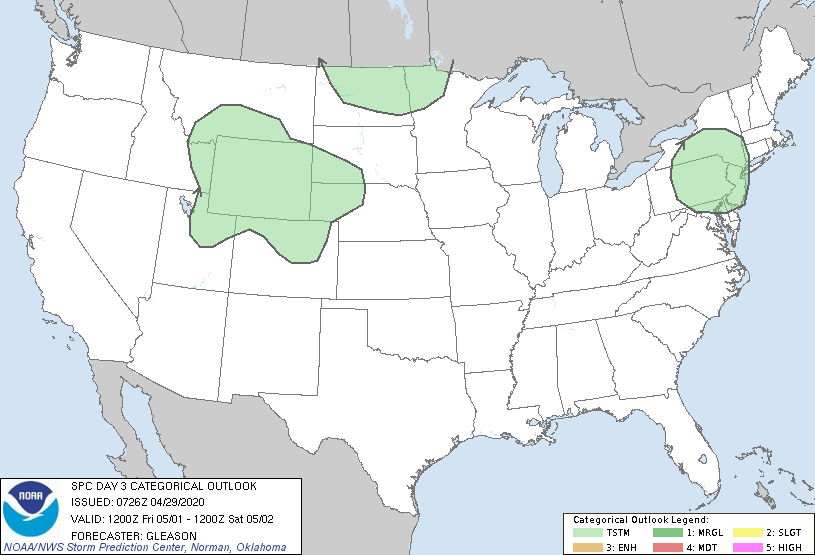
SPC Day 3 outlook (for 5/2/2020)
Right now, SPC has a general thunderstorm threat out for the area on Saturday. This looks good to me as we are still a bit too far out for finer details on that storm system and what it may mean for us in terms of what or any severe weather we see. For now, I’d put chances for storm in the 30%-40% range for late Saturday with a small chance of severe. Stay tuned for updates as we will be tracking that disturbance though the week and will be sure to give you all ample heads up if we see something interesting!
Breaking Down Severe Weather Ingredients this Weekend
[s2If current_user_can(access_s2member_level1)]
If you recall from our earlier discussions, we have 3 basic ingredients for thunderstorms to form. We will take a look at how these are all lining up on Saturday and you’ll see why I’m keeping an eye on that day for our first shot of severe weather. One thing to keep in mind here: this is as far out as the NAM goes, so while we see things on this model at this time, remember that this is still open to a lot of change as we go through the week. This is just a snapshot of what we see right now.
Moisture
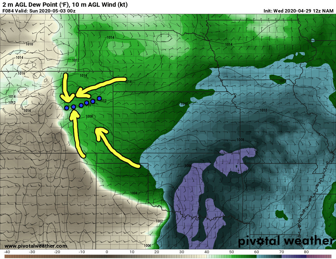
Surface winds and dewpoints Saturday late afternoon/evening (NAM model)
As the storm system swings through we see surface winds out of the east to Southeast… this is usually relatively efficient at transporting moisture into the area and in this case the model shows dewpoints in the 50’s behind this feature. Additionally the southeasterly winds South of Denver and northeastherly to northerly winds north of Denver can often crash together forming what we like to call a “Denver Cyclone” This is an area to watch for thunderstorm development as the converging air can cause a lot of lift.
Lift
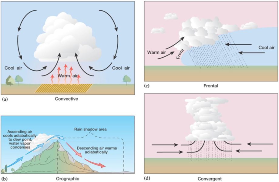
If the model snapshot above holds, we know we will have a lifting mechanism in terms of converging air over the Palmer Divide and areas just East of Denver. Also, there should be enough heating to allow convective lift as well. The types of lifting mechanisms we could see are convective, frontal or convergent. It is possible upslope along the Palmer Divide could enhance lift… so really any are at play with this setup.
Instability
We can measure instability in the atmosphere by looking at CAPE (convective available potential energy) and recall; instability is the tendency for the air to continue to rise in the atmosphere if we lift it with moisture. So this adds on to the two ingredients we mentioned above.

Surface Based CAPE for late Saturday (NAM Model)
Surface based CAPE is the cape at the surface, note the NAM has values close to or around the 1,000 j/kg range… that is relatively high for eastern Colorado. If we look at mixed layer CAPE (the layer above the surface layer higher in the atmosphere) we see a similar output.
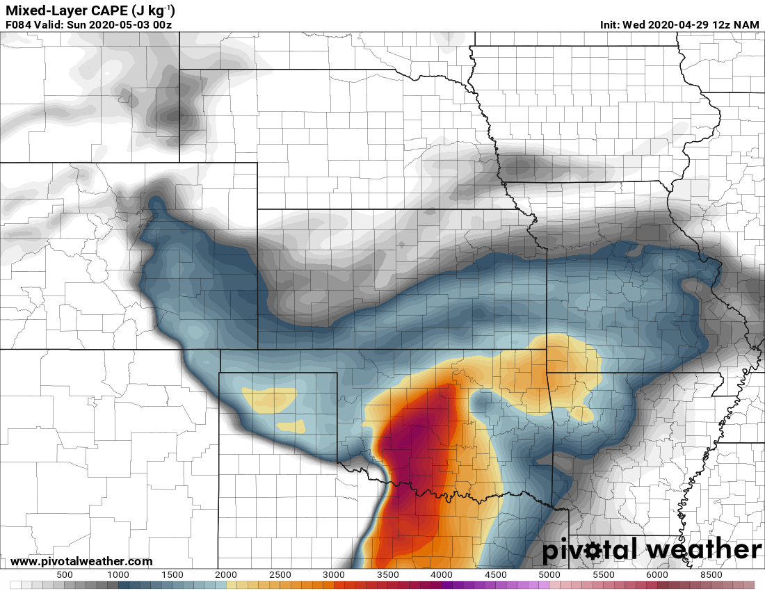
Mixed layer CAPE for late Saturday (NAM Model)
For severe weather we need to also keep an eye on wind shear, this is what will allow these storms to sustain themselves longer and grow stronger. Additionally, rotating storms have stronger and more organized updrafts which means a higher likelihood for hail.
Wind Shear
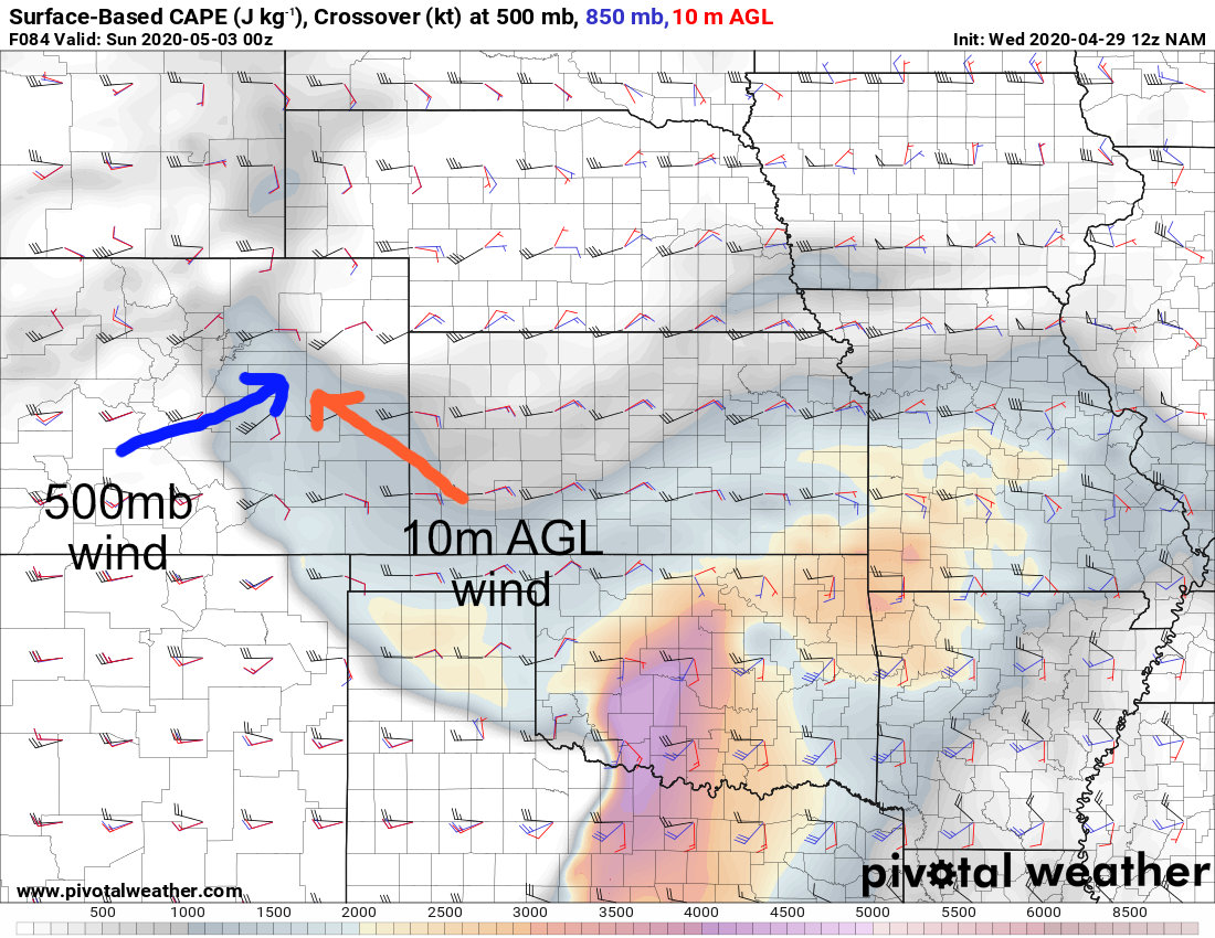
500mb/10m AGL shear/CAPE composite (NAM model)
The image above is an overlay of surface based CAPE (instability) along with wind direction and speed at 500mb (18,000ft above sea level) and 10 meters above the ground. Notice that winds are mainly out of the Southwest aloft and out of the Southeast or East at the surface. This is another clue that we may see some bigger storms develop that can sustain themselves long enough to become severe.
What Does This Mean for Saturday?
When we look at this model, the ingredients are there but we are on the furthest range it can see. As we know with snow storms, the further out you get the more difficulty models have at determining finer details. Right now we can’t make any concrete forecast about severe weather on Saturday, but given what is showing on the models it is definitely telling us to “keep a close eye” on Saturday through the rest of this week!
[/s2If]
[s2If !current_user_can(access_s2member_level1)]

If you’re already a site supporter, be sure to login to see this special content! Thank you!
[/s2If]
Summary
Looks like things will get a bit more active for us in the coming days. Keep in mind, with the moisture we’ve had in the spring this year, we may see an active severe season along the front range if the other ingredients (besides moisture; i.e. wind shear, lift, instability) come together.
To recap above:
- Thursday
- Warm temperatures, dry conditions
- Highs in the upper 70’s to low 80’s across the Palmer Divide
- Highs near 90 possible in lower elevation areas like Denver and SE Colorado
- Friday
- Warm temperatures, dry conditions
- Highs in the mid to upper 70’s for Palmer Divide
- Warmer low to mid 80’s for lower elevation areas
- Saturday
- A bit cooler, watching for thunderstorms later in the day
- Will need to keep an eye out for severe weather threat
- More details coming through the week
Have a good day, keep it tuned here for updates about Saturday through the week!
