As we continue Severe Weather Preparedness week here on MountainWave Weather, let’s talk a little about how we can get an idea of if severe weather is possible, when it’s coming and how widespread it could be. The Storm Prediction Center in Norman Oklahoma outputs convective outlooks for up to 8 days, but the day 1-3 are the most detailed. Like a lot of forecasts, we can’t get a good idea of finer details more than about 3 days out on any particular storm system and definitely not on smaller details like individual storm chances.
Several times per day, the Storm Prediction Center will upload a map and discussion pertaining to that day’s severe weather outlook and risk. They usually look something like this:

Day 2 categorical outlook for April 27, 2020
For reference; day 1 is the current day… day 2 is tomorrow, day 3 is the day after tomorrow and so on. This is handy to know when looking at these maps. A categorical risk map like the one above will have different colors notating the threat level for severe weather.
The Storm Prediction Center – Risk Categories

Categories and their meanings:
- Light green (very common in Colorado)
- Means a general thunderstorm threat containing thunder/lightning, flooding under heavier rain, wind gusts up to 40mph and small hail
- We see a lot of days like this in spring and summer in Colorado. Sometimes storms on days like this can quickly “pulse” to a severe storm and die off quickly depending on the atmospheric setup that day.
- Dark green (common in Colorado)
- Marginal severe threat – any severe storms will be widely isolated in nature (none to only 1 per county roughly)
- Any severe storms that form likely won’t last long and won’t have a high intensity for long
- On these types of days, Elbert County could see 1 severe storm form and move East while surrounding counties to the North and West may see nothing or just general thunderstorms
- Yellow (somewhat common in Colorado)
- Slight severe threat – more numerous severe storms are possible but still scattered in nature
- Most storms that form and reach severe levels will be short lived in duration and intensity, a spotty stronger severe storm is possible
- This type of risk is somewhat common for our area, especially during peak hail season
- Orange (somewhat rare in Colorado)
- Enhanced severe threat – on days where the atmosphere is a bit more primed we see these in Colorado
- More widespread severe storms are possible with a few of those possibly growing intense with large hail, damaging winds and tornadoes
- This type of risk is a bit more rare but still somewhat common for our area, especially during peak hail and tornado season
- Red (rare in Colorado)
- Moderate severe risk – this risk category is often found in areas East of Colorado
- Usually pertains to a stronger/ more widespread severe weather threat including very large hail and large tornadoes
- This type of risk category is rare in Colorado, especially outside of the far Eastern plains, but it can happen!
- Fuchsia (very rare in Colorado)
- High severe risk – I’ve only seen this issued maybe a couple of times in my lifetime in Colorado
- This risk area is the highest category and is often issued for areas that will likely see many severe storms, very strong in nature with large hail and violent/long track tornadoes
- Extremely rare in Colorado as we don’t often have atmospheric conditions to sustain widespread severe storm and especially large/violent tornadoes
Severe Weather Climatology
When you define severe weather for Colorado you have to include: wildfires, flooding, hail, wind, tornadoes – this means severe weather season is pretty much all year in our area. As we move into spring though, we start to see more thunderstorm related severe weather; more specifically hail, wind and tornadoes. With summer comes different threats like microbursts, hail, flash flooding and fires if it’s a dry season.
Like most things with the weather, we like to play the odds game to see when/where we’re most likely to see severe weather. The Storm Prediction Center has some handy graphics to help illustrate these things:
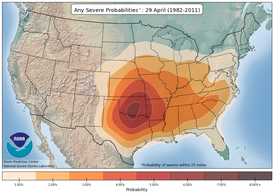
Probability of seeing severe weather (general) within a 25 mile radius on a given day (in this case April 29, 2020)
I took a snapshot of where we are right around this time in April. As you can see, highest probability of seeing any severe weather is still well to our South and East. Usually we don’t have enough heating and instability in late April to see much of a severe weather threat never-mind a thunderstorm threat. It can happen though, we’ve had years where we’ve seen hail and tornadoes in April… it’s just far less common. The image above shows that defined area pretty well.
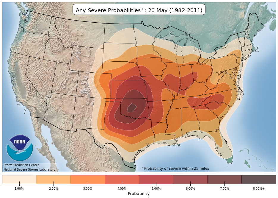
Severe weather probability within 25 miles on May 20 (mid/late May)
As we move into May we typically start seeing more heating, more instability, a healthy dose of moisture and good wind shear compliments of the jet stream shifting from South to North. May is not the peak of our severe weather season but it is when things begin to wake up. By mid/late May we start to see more consistent thunderstorms and severe weather (during drought years though, this may not be the case.)

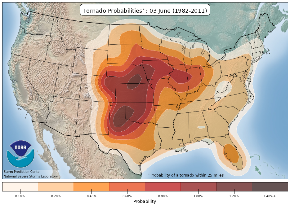
Severe weather probability within a 25 mile radius in mid/late June
Finally, by early to mid June is when severe weather season usually peaks for us in terms of hail and tornadoes. This time is when the best chance of all ingredients coming together for thunderstorms and severe storms occurs. We usually have good moisture, strong winds aloft from the jet stream and strong heating and instability due to warm surface temperatures and relatively cool temperatures aloft leftover from late winter/early spring.
Sneak Peak: Tornado Climatology (When’s Your Best Shot at Seeing A Tornado in Eastern Colorado Typically?)
[s2If current_user_can(access_s2member_level1)]
Tornado specific severe weather climatology for early June
Tornado season in Colorado typically peaks the last week of May and first week to second week of June. If you’re looking at the time with the highest probability of storms with tornadoes that is it.
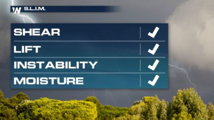
The ingredients tend to line up best during this time:
- Wind shear: provided by the jet stream and storm systems shifting wind at the surface
- Lift: due to convection (heating of the surface) or orographic (terrain due to upslope)
- Instability: warm at the surface due to heating but still cool aloft in the atmosphere
- Moisture: due to storm systems bringing it in or evapotranspiration from the ground
Want to see a tornado or storm chase with the best odds? Last week of May and first 2 weeks of June are your best time!
Another note: you can use Skew-T Log P Diagrams to scope out lifting mechanism, how unstable the atmosphere is and what the winds, dewpoints and temperatures are doing aloft. These are launched twice per day, daily from Denver’s NWS office.
You can see Denver’s daily soundings here
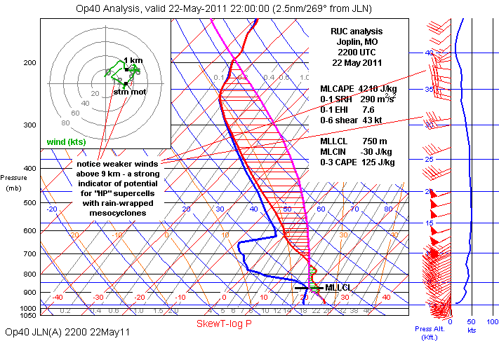
Let me know if you’d like to know more about how to read these, it’s something I’d be more than happy to do for supporters. As always, thank you for the support!
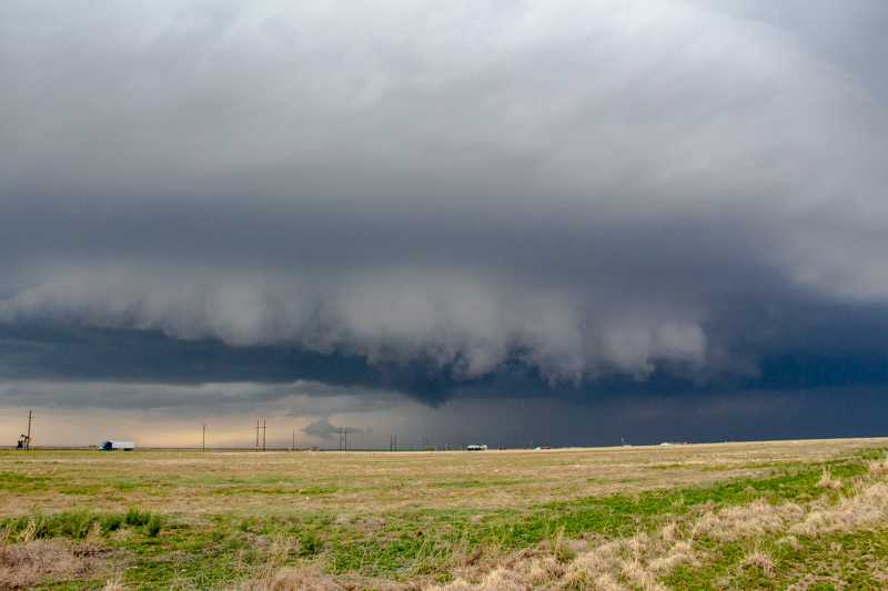
The above example is of what is called a “loaded gun” sounding. We don’t see these often here in Colorado but on days where strong tornadoes are possible out East they are common. They illustrate a perfect combination of wind shear (veering winds) moisture, a capping inversion and instability. In the above example, 4000 j/kg shows an extremely unstable atmosphere
[/s2If]
[s2If !current_user_can(access_s2member_level1)]

[/s2If]
How to Check the Day’s Severe Weather Threat
Here’s quick timeline of how you can know severe weather is coming in advance and what to watch for:
- 2-3 days out
- Check the Storm Prediction Center’s Outlook, they will be updated several times leading up to the event so be sure to keep an eye out for shifts
- Morning of
- That morning, check the SPC Day 1 outlook; categorical and probabilities for hail, wind and tornadoes will be detailed
- Local TV news also usually will display SPC data and talk about the day’s threats and areas
- Afternoon of
- Check an accurate weather source for changes to the forecast
- Have a good way to get watch/warning information from a reliable weather source
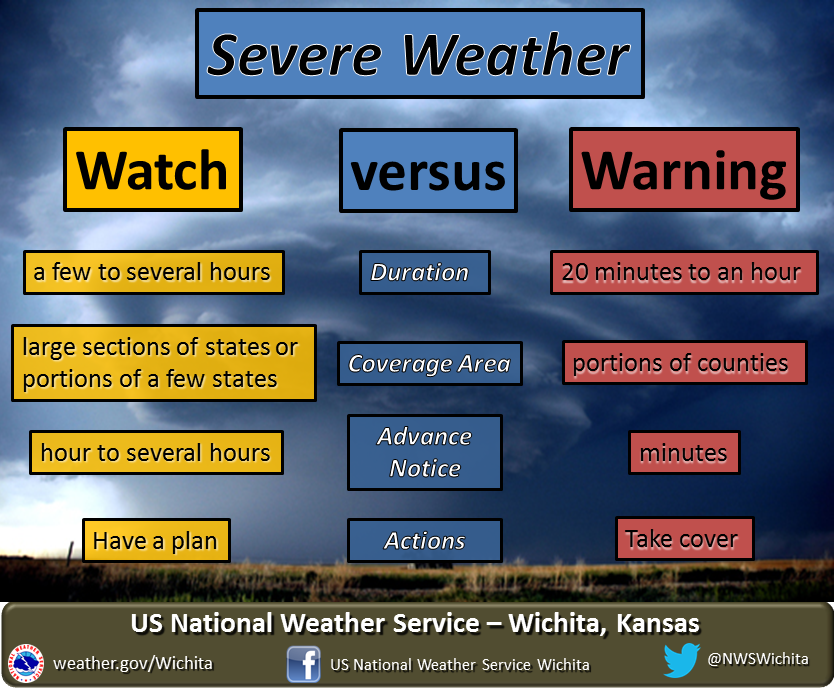
Know the difference between a watch and a warning;
- A watch means the atmosphere is conducive to severe weather
- No immediate action is needed, but have a way to get warnings/alerts and be ready to act
- A warning means something is occurring or imminent
