We’ll be watching the weather closely today as we are beginning to see the makings of our first severe weather threat day of the season. Before we get all excited about that though, understand that it’s not going to be a red-letter day for severe storms by any means. Nearly every parameter we look at is “marginal” at best for severe weather this afternoon and typically setups like this early in the season don’t do much.
Still… it’s something! Let’s take a look at some of the specifics:
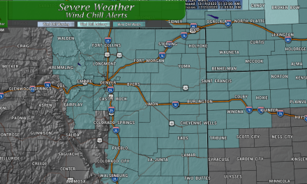
Palmer Divide – General Threat Discussion
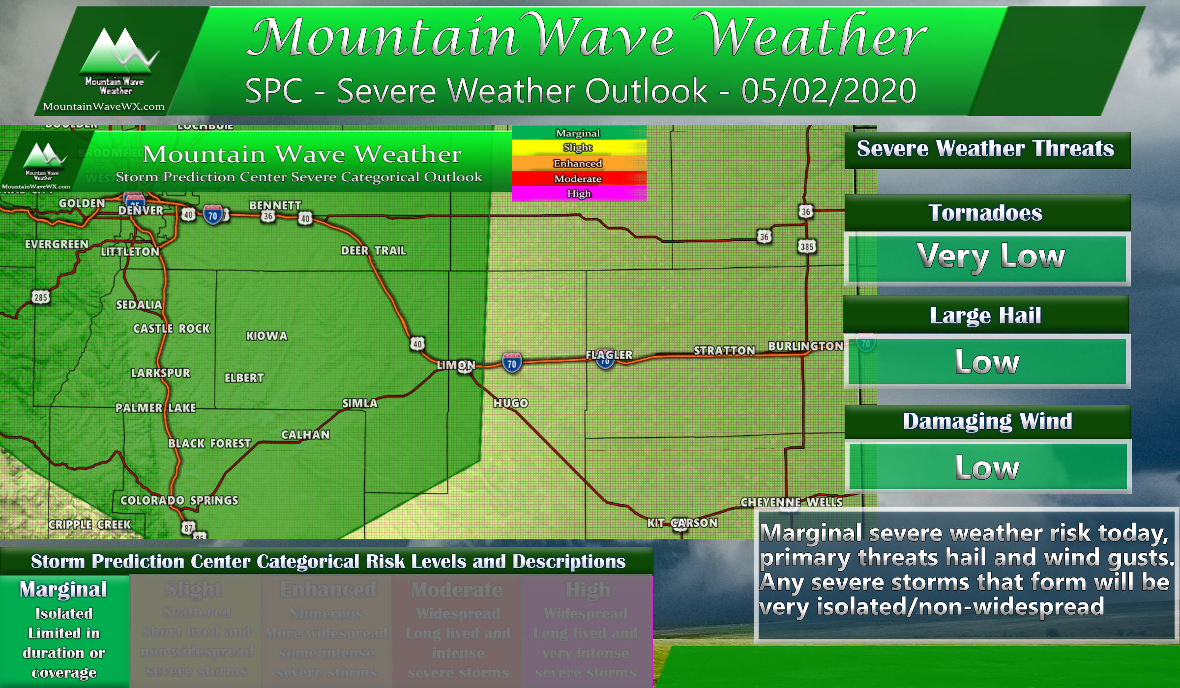
SPC Risk area updated as of 12PM on 05/02/2020
The threat area outlined by the Storm Prediction Center encompasses pretty much the entire Palmer Divide region. The darker green notates a “marginal risk” which means severe storms will be possible but unlikely that most in this area see them. Put it this way; if you live along the Palmer Divide your chances of seeing a thunderstorm are around 50-60%… but any one of those storms going severe is about 10% so we’re not getting too bent out of shape about the possibilities today.
Tornado Threat
- Remains pretty low for this system. Low level wind shear is nothing fantastic and low level instability isn’t great either. These are two ingredients we expect to be in better shape to see tornadoes. Still, the probability is not 0% because we can always see a brief spin up along the Palmer Divide on convergence boundaries that form. If you should see a tornado today at all, consider yourself lucky and possibly go buy a lottery ticket.
Hail Threat
- Overall is low just because of the isolated nature of severe weather. On a day like this, we don’t expect huge hail either. We could probably see hail up to or slightly larger than 1 inch in diameter, but again that will be very isolated. So today the threat remains pretty low, but higher than seeing a tornado.
Damaging Wind
- Pretty similar to the hail threat; low because of the isolated nature of any severe storms but the threat is still there
Timing/Impacts
As far as timing, most models have storms firing off after 2-3PM but the shorter range HRRR has held off on any larger storms until the 5-7PM time frame along the Palmer Divide. None of the models are particularly excited about how large these storms get, but suffice to say I’d watch the Eastern Douglas County region, into Elbert County and perhaps central and Eastern Arapaho county this evening. I’d probably also keep an eye on areas immediately East of DIA and potentially in Northern Colorado East of I-25 as well.

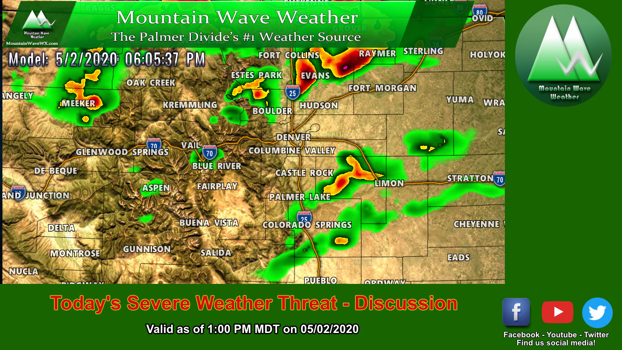
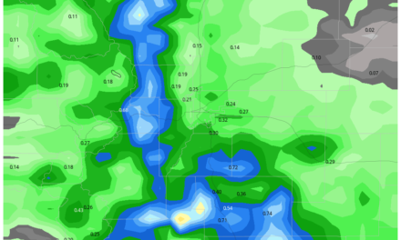
HRRR model snapshot around 6PM
Interestingly enough, the area I’ve outlined above is not based on what the model is showing (HRRR is good with showing whether there will be storms but is bad on timing and positioning) – it’s more an area that is defined when you look at the best area of lift, instability coupled with decent moisture. Remember, don’t just forecast what the model says, there’s a lot more moving parts!
Storm Chasing Today?
Game-time decision, I’ll probably have an answer by 3-4PM. It’s not a great looking day in any case; super low tornado threat, wind shear is bad and instability/lift is marginal at best. If I do venture out it’ll probably only be close to home along the Palmer Divide.
If you see me driving through your neighborhood… it probably means something interesting is coming.
Otherwise, have a happy Saturday!
