Model data continues to consistently show a strong storm forming and impacting Colorado late Monday into Tuesday. A new slew of Winter Weather Highlights has been issued by the NWS with some strong language (I have those details below.) A ton of data continues to stream in and while there’s still some differences in the track of this storm (remember that is extremely important) NWS and a lot of mets around the area have begun to issue preparation instructions.
At this point in time there are a few things to remember:
- Models have been incredibly consistent, when they are all calling for a large storm like this we have to get folks prepared for a worst case scenario
- If the storm falls apart that’s fine, but if it gets as bad as predicted we’d rather have people prepared and off the roads
- Models still show biggest impact North of the Palmer Divide. This doesn’t mean we won’t see anything down there, it just means we have to keep a close eye on how the system progresses. If it wobbles North a tiny bit we could see lesser snow South of Denver.
- For right now, we have to consider any area within the warning fair game for heavy impacts.
Let’s update the highlights:
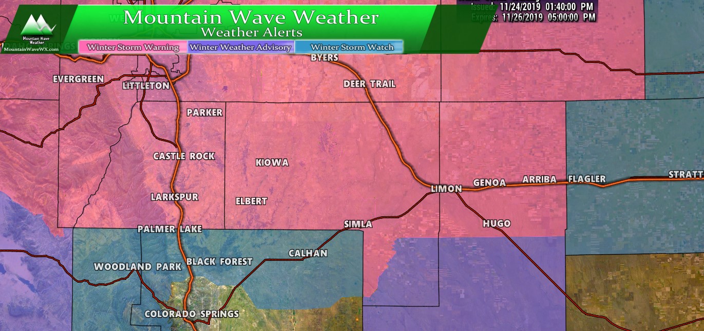
Watches/Warnings/Advisories
URGENT - WINTER WEATHER MESSAGE
National Weather Service Denver CO
140 PM MST Sun Nov 24 2019

...HEAVY SNOW LIKELY MONDAY NIGHT INTO TUESDAY...

.A winter storm will strengthen as it moves over the mountains
and across northeastern Colorado and neighboring states Monday
night into Tuesday. A large area of heavy snow is likely from the
northern Colorado and southern Wyoming mountains eastward into
western Nebraska and northwest Kansas. The heaviest snow will
begin in the mountains Monday afternoon and spread southeast to
the Denver-Fort Collins area during the evening, and across the
rest of northeast Colorado by about midnight. The snow will end
from west to east during the day Tuesday. The heaviest snow is
likely to occur late Monday into the early morning hours Tuesday.

This storm will likely cause significant travel difficulties due
to the amount of snowfall. A widespread area with a foot of snow
from about Interstate 70 northward is possible. Conditions will
deteriorate Monday evening and will be worse on Tuesday morning
just after the heaviest snowfall occurs. While blizzard
conditions are not expected, north winds at 15 to 30 mph will
produce some blowing and drifting snow on the plains during the
day Tuesday, which may hamper plowing of roads. Conditions will
improve Tuesday afternoon as the snow moves eastward and winds
decrease.

People planning travel in northeastern Colorado Monday night or
Tuesday should monitor future forecasts and begin to consider
alternatives. There is a chance that travel could become
nearly impossible across the I-25 urban corridor and across much
of the northeast plains including the I-76 corridor by Tuesday
morning, so residents should be prepared for that possibility.
Closed or impassible roads due to heavy snow are possible in the
warned area.
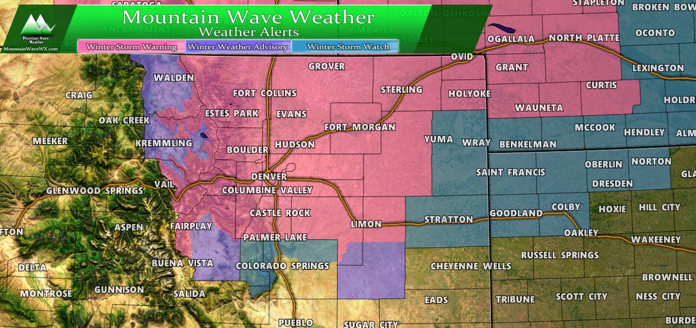
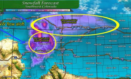
View of Winter Weather Highlights as of 2PM 11/24/2019 for Colorado, Western Kansas and Western Nebraska.
This Winter Storm Warning has been issued for:
Travel could be very difficult to nearly impossible
across the area, especially by Tuesday morning. The hazardous
conditions will impact the Tuesday morning commute.
Full watch/warning details are available here.
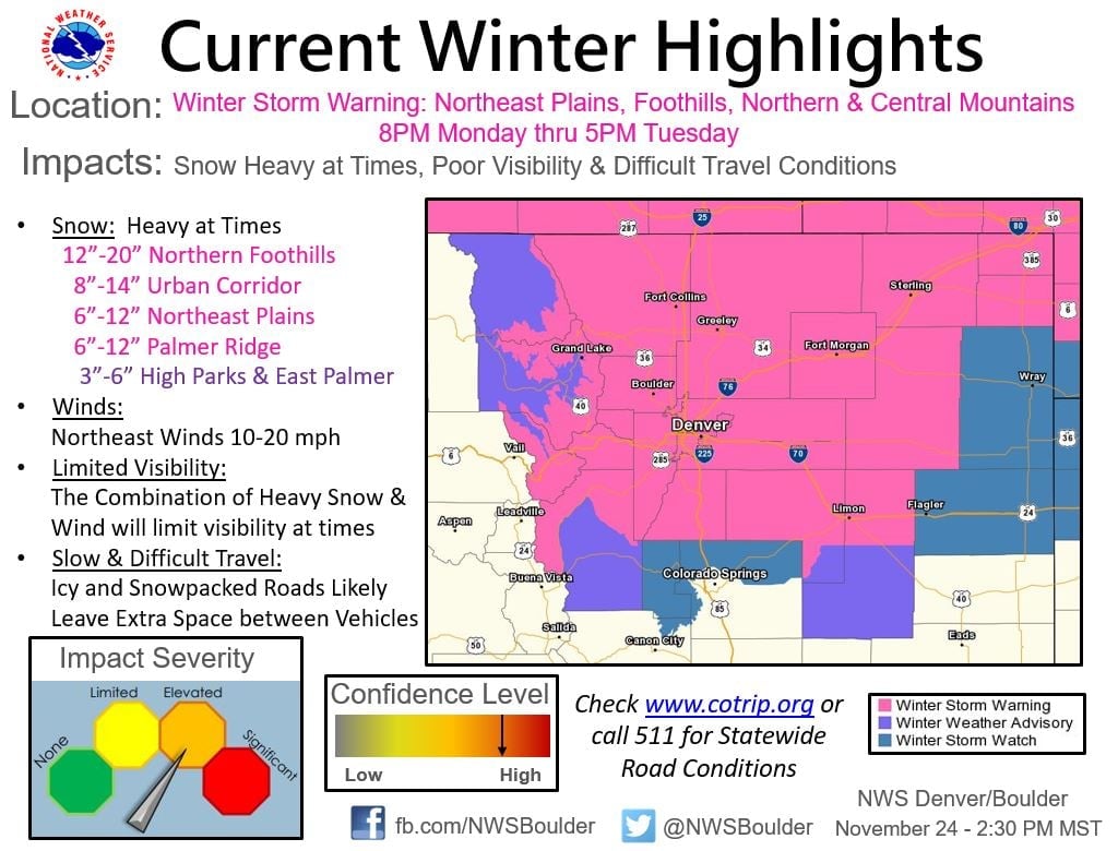
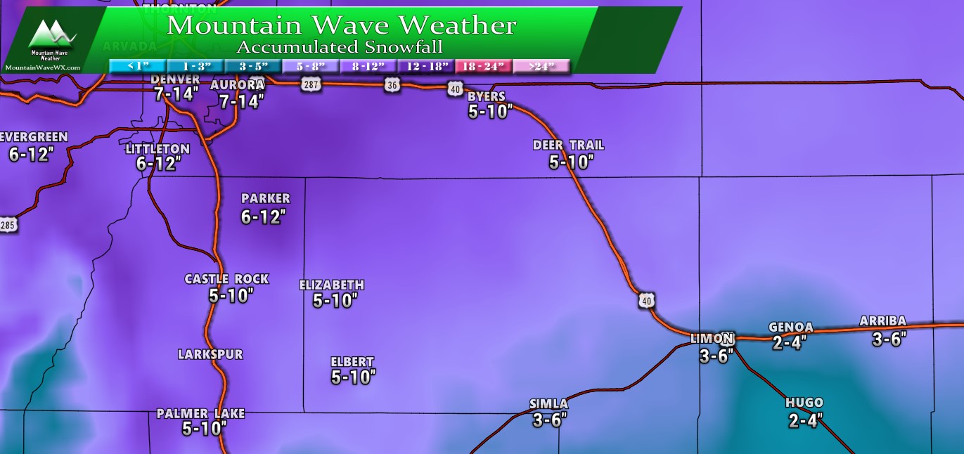
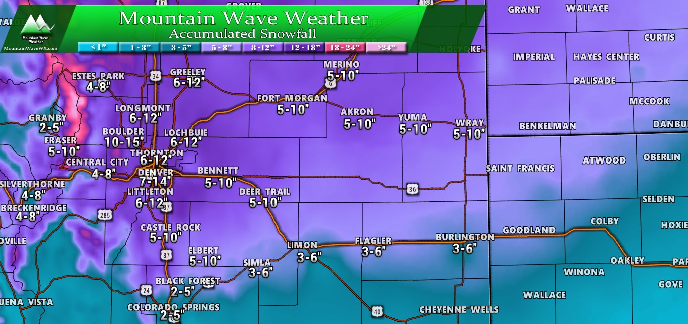
Here’s the latest NWS information and snowfall totals for reference.
Forecast/Hazards/Timelines/Impacts (The Need to Know Planning Stuff!)
These details are largely the same as my morning post with a few slight tweaks…
Impacts
Snowfall/Travel Impacts
- Denver metro and areas North and East – expecting potential high impact event
- Areas South of Denver/ Palmer Divide – expecting a medium to high impact potential
- Heavy snow will be likely late late Monday and into early Tuesday
- Winds will be strong enough that localized Blizzard conditions will be possible
- Airport delays and cancellations will be likely late Monday and early Tuesday – check with your airline!
- School cancellations and delays will be possible Tuesday – check with your school district!
Timing
- Monday
- Current modeling suggest snowfall begins during the evening hours on Monday
- Still some uncertainty as to whether the Monday evening commute is impacted or not… stay tuned on that.
- Later evening into overnight Monday, snow will become heavy across many areas
- Travel is not recommended overnight Monday into Tuesday morning
- Tuesday
- Heavy snow is possible Tuesday morning
- Expect high to severe impacts to Tuesday morning commute
- Snow looks to taper off towards Tuesday afternoon/evening hours
- Wednesday
- Storm exits the area
- Still expect lingering impacts depending on how long storm sticks around on Tuesday and how much snow accumulates
Please note: if you are out and about Monday, please plan on being off the roads by late evening hours. The Winter Storm Warning goes into effect at 8PM, meaning travel is discouraged after that point.
Snowfall – No Changes from Morning Post
The models have continued to show snowfall amounts to varying degrees within these ranges. The biggest uncertainty on snowfall is along the Palmer Divide surprisingly. If it looks like the storm will wobble North we may adjust snowfall totals down. There’s some evidence of that but not enough to move on as of right now.
As such, these numbers hold for now but changes will be likely over the next 24 hours especially for areas South of Denver.
For the Weather Nerds…
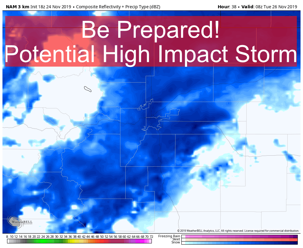
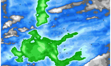
Unbelievable how consistent models have been with this storm. The last time I can think of seeing this much consistency at such a far out time period was March 2019. With that I figure I’d post what the models are showing for snowfall as of this post, feel free to click through them and see for yourself…
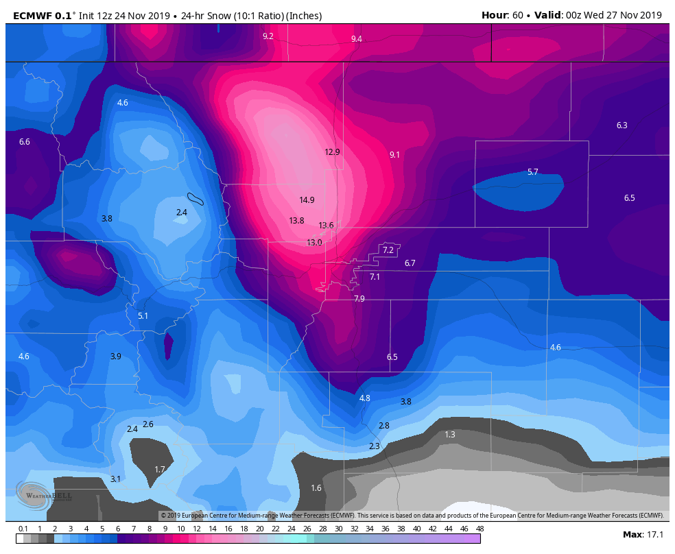
Euro 24 hour snowfall forecast through 5PM Tuesday 11/26/2019
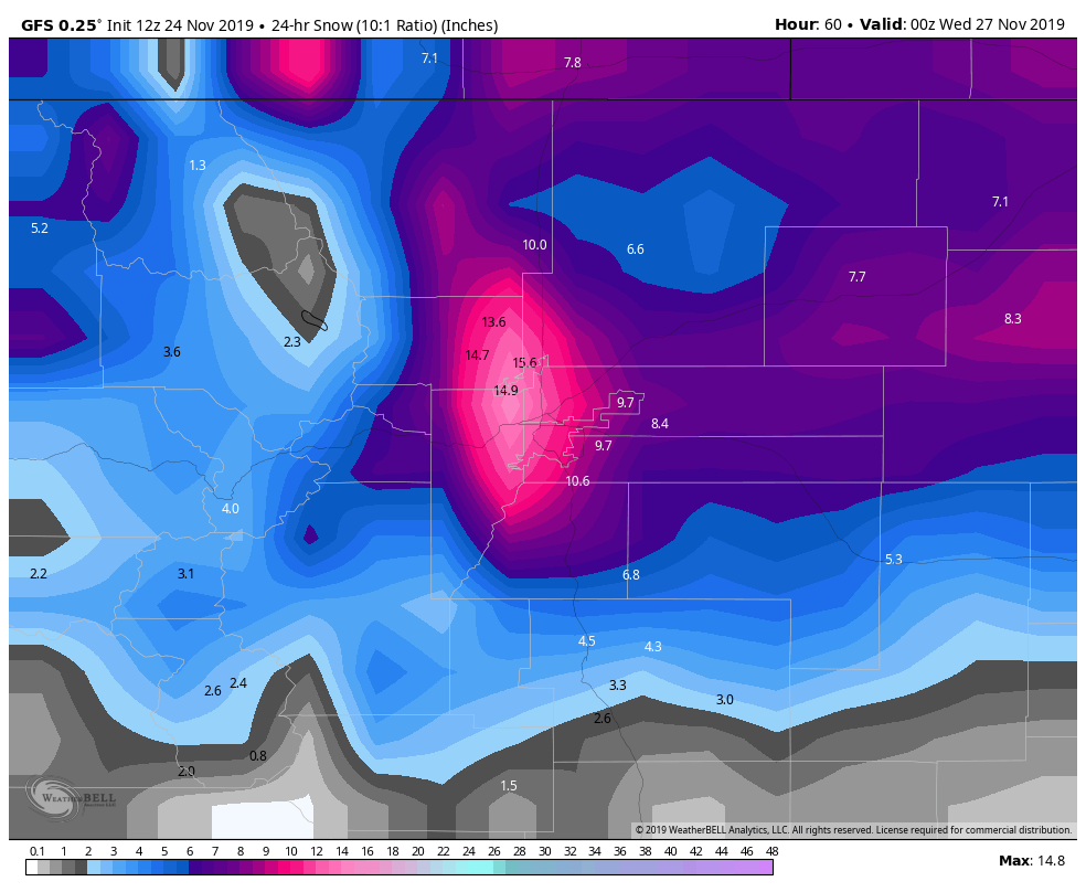
GFS 24 hour snowfall forecast through 5PM Tuesday 11/26/2019
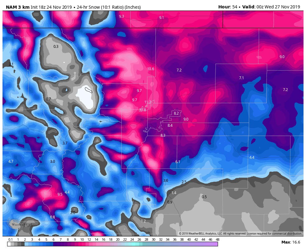
Nam3K 24 hour snowfall forecast through 5PM Tuesday 11/26/2019
If you’re a weather nerd it’s simply fascinating to see this. If you’re a forecast it gives you decent confidence in what you’re seeing, a rarity we are often not afforded. While these photos are just one snapshot in time, the models have largely been in lock-step for over 24 hours now… wow!
Do look at these and recognize the similarities and differences; similar solutions in similar regions means higher confidence while differences between (even slight) the models can show uncertainty…
- Similarities
- All models show heaviest snow North and Northwest of Denver
- All models show decent snow accumulation across Northeastern Colorado
- All models show decent snow accumulation across the Palmer Divide
- Each model shows that areas around and further South of Colorado Springs may not see much from this storm
- Differences
- Notice the areas of heaviest snowfall accumulation are slightly different between the models
- How far South the heaviest snow makes it; that line wobbles a bit back and forth between model runs
- This why we only have medium confidence of snow totals over the Palmer Divide right now, while we have higher confidence of Denver and points North and West seeing higher snow totals
- How much snow the eastern plains ultimately see is a bit different, again this is a medium confidence situation with those numbers.
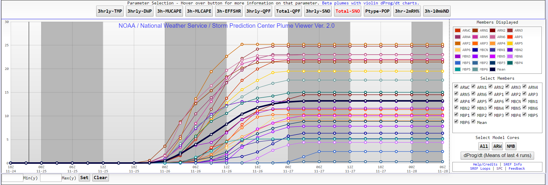
SREF plume viewer for snowfall at Centennial Airport
Heck, I threw in the SREF ensemble for this storm. To use this product you have to understand how it works and its mannerisms; it tends to overdo snowfall totals fairly consistently but it has value as another check to the other models at this point. So, while I think the mean it’s showing here is a bit high, it lends credence to that 5-10 inch range I’ve put most of the Palmer Divide under.
The station at Monument Hill shows a similar number, again re-enforcing the other models and the range I’ve specified for that area as well.
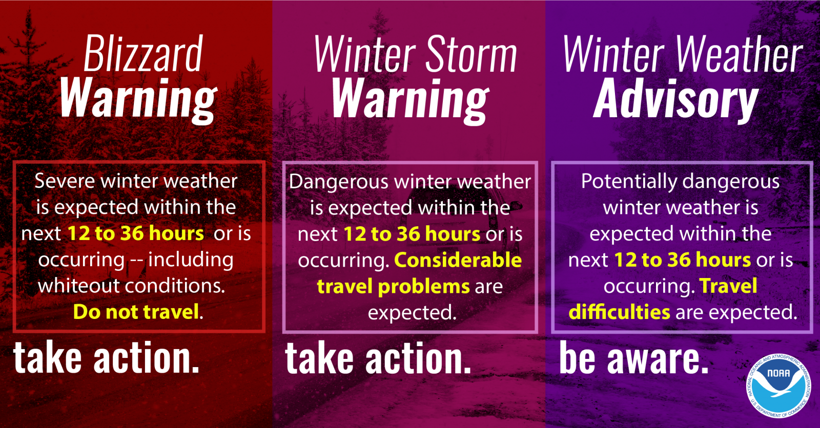
Summary
Looks like we will run the gambit with this storm for Winter Weather Highlights, here’s quick refresher on what they mean:

