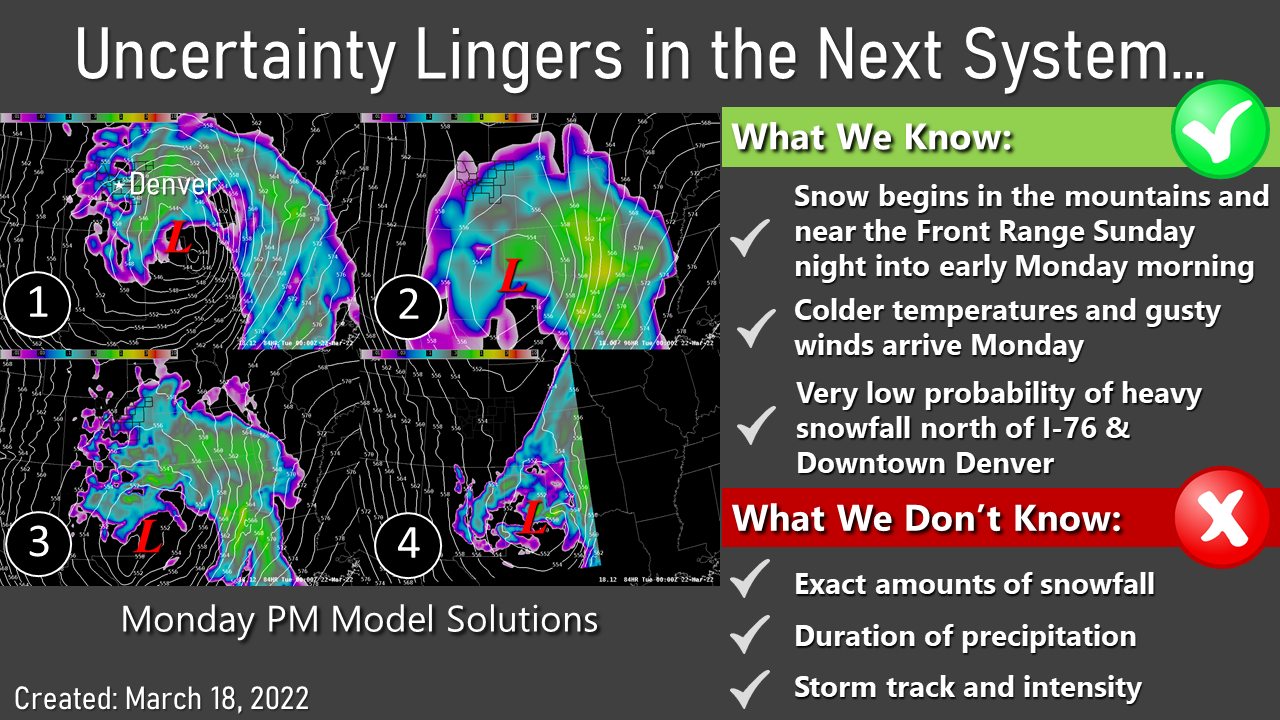
Models – Still Grappling with Uncertainty
But a trend is starting to emerge, most models are pushing the storm system Southwards which has pretty big implications for what we see in Colorado in terms of snow and where we see it.
These are model ensembles, consisting of a ton of runs for each model with slightly different parameters. These can help smooth out the outliers in a model solution
I’ve outlined the three ensemble models above, because when we have a storm system with such high uncertainty, the ensembles can help smooth out the outliers. We don’t want any outliers when trying to figure out a forecast like this because it can drastically skew results one way or another.
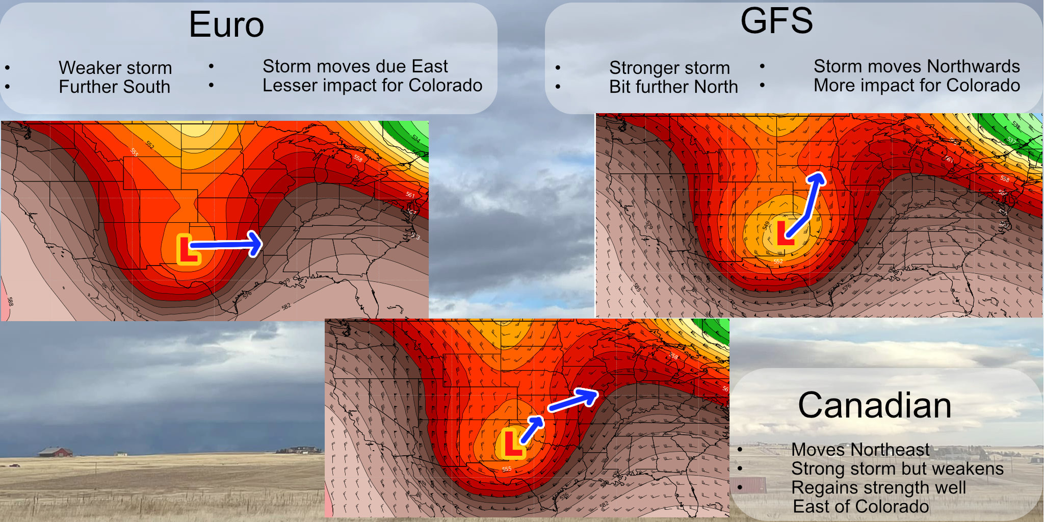
The European Model
- Has a weaker system overall, in many cases it struggles to close off the low over New Mexico. This would mean the storm has trouble re-intensifying and a weaker storm system is possible overall.
- The anticipated track moves more Eastward than Northeastward, meaning the bulk of the moisture stays well Southeast of Colorado.
- Currently this product is forecasting 2-5″ of snow, mainly across the Palmer Divide with very little amounts into Denver and Northeastern Colorado. Only upslope favored areas see any meaningful snowfall out of this solutions (Palmer Divide and Raton Mesa in Southern Colorado.)
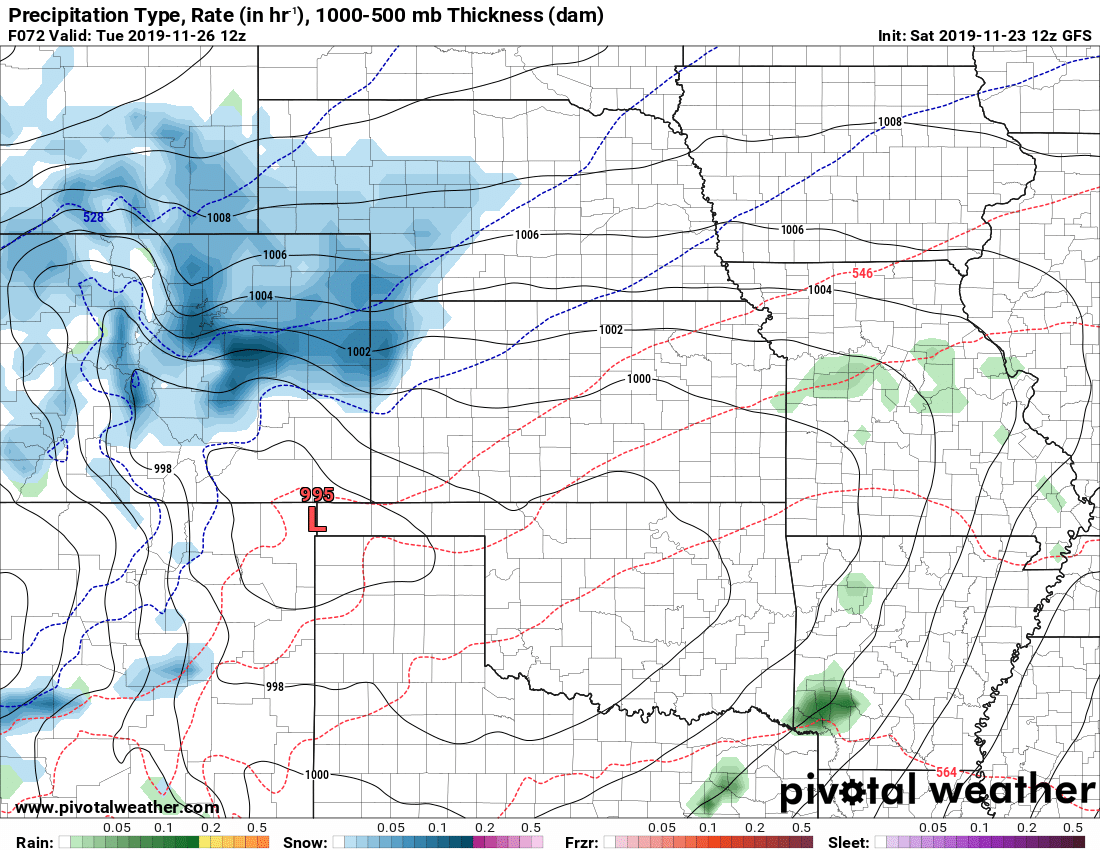
The GFS Model
- This particular models closes of the low and intensifies it into a fairly strong storm system. Please not however, the trend with this model in the past few runs has been to also shift this storm system to the South.
- Movement shifts Northeastwards which has the low track across far Southeastern Colorado and into Western Kansas. This would be a much more favorable track for Colorado’s front range.
- This run is currently prediction 3-7″ of snow, again mostly along favored upslope areas like the Palmer Divide and Raton Mesa. Raton Mesa is much more heavily favored for higher snowfall than other areas further North.
The Canadian
- Has a strong storm system that falls apart as it moves Northeast. The storm re-intensifies in Kansas meaning a pretty powerful storm system for the plains but leaves Colorado in the dust as the storm strengthens too far East to make an impact.
- Similar to the Euro, this model is predicting around 2-5″ mainly around those upslope favored areas.
What About the Deterministic Models?
The deterministic models are mainly falling along their ensembles, so I won’t say much on those other than that they also favor upslope areas for the higher snowfall amounts. I say higher with hesitance because even these models have significantly dropped snowfall totals across the area.
Here’s the National Blend of Models:
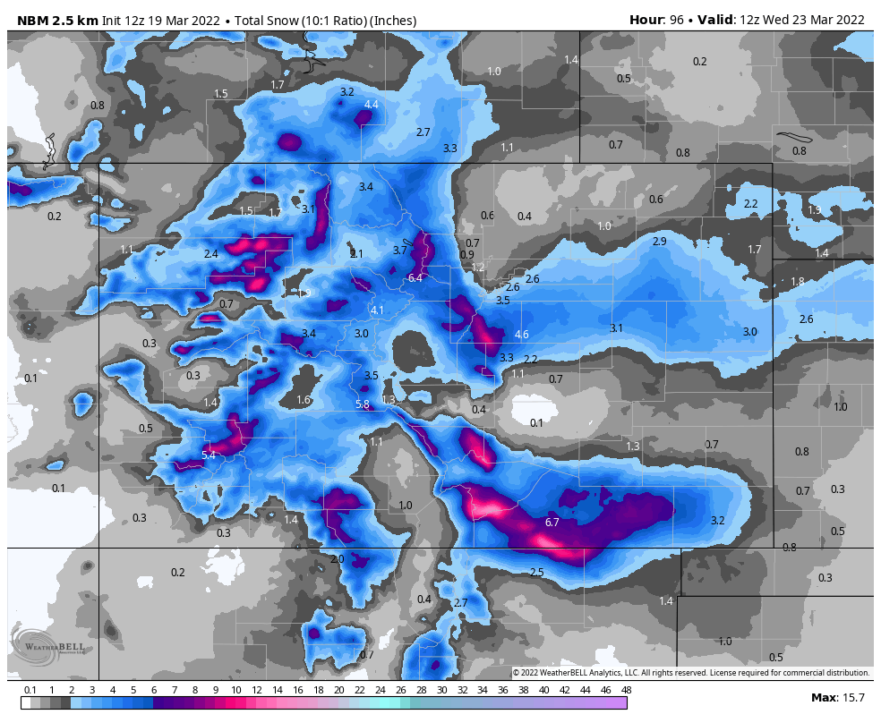
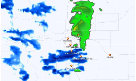
Snowfall Forecast
There is still a ton of uncertainty with this forecast and snowfall amounts are still a bit elusive. I can say the overall trend over the past few runs of many models has been to significantly drop snow accumulation amounts across the state.
The best chance for snow at this point is still upslope favored areas, let’s diagram this out a bit:
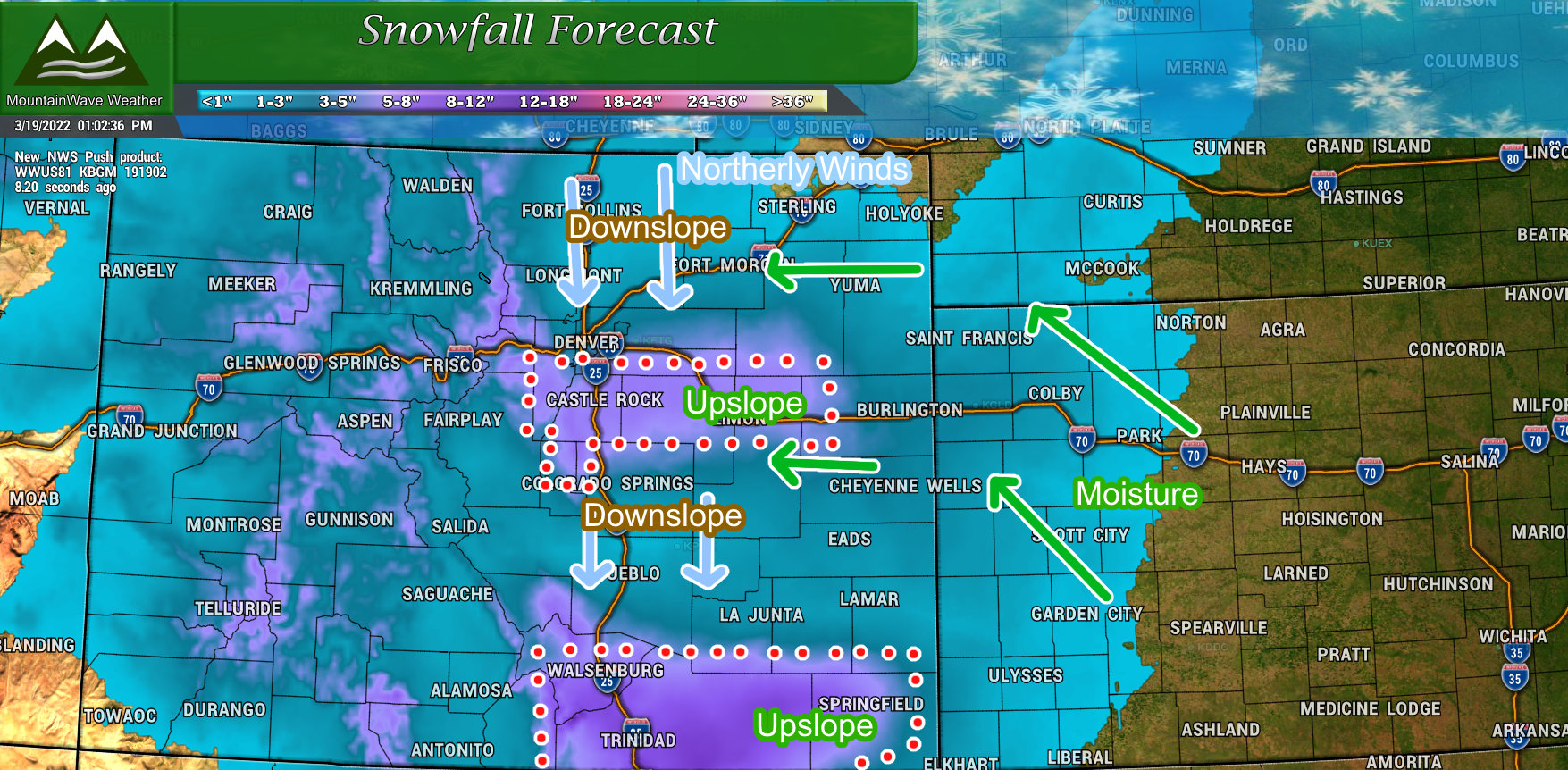
I’m no John Madden, but here’s the setup for this storm potentially…
A few bulletpoints with the graphic above:
- Moisture comes in from the East, if this storm taps into the Gulf there could be quite a bit of it. Should the storm continue to swing further South, that moisture source will move further South out of our area.
- Strong northerly winds will be likely with this storm, especially East of I-25. Those winds will take that moisture an lift it against the terrain (upslope) while sinking the wind and drying it out on the other side of the terrain (downslope) This means those higher terrain/upslope favored areas will have the best chance at acumulating snow. Areas like Denver and the Springs may not get much at all except for wind out of this one.
Summary
We still need a lot more data to come in to see how this storm behaves, but as of right now it is looking less significant than it did a couple of days ago. That doesn’t necessarily mean this storm is dead to us, but if we see continuing trends like we’ve seen with the models – we may be looking at a low end or non-event for us early next week.
I’ll post this information from the NWS shared yesterday since it is still relevant today:
All in all, don’t write this storm off yet as things can still change. But the overall trend has been downward in severity for this storm system since yesterday. I’ll keep an eye on the data coming in today for more clarity and update as needed!
