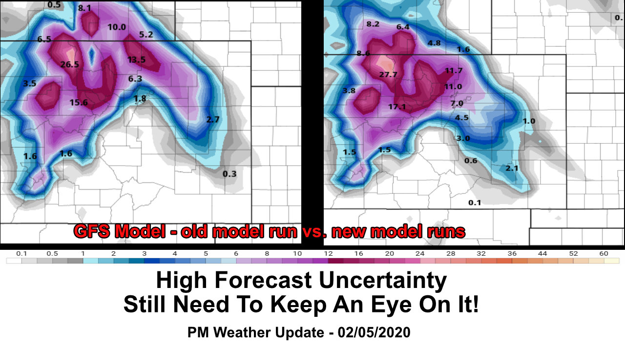
There’s a lot of data coming in our next storm system and a lot of it is not helping with our confidence in the forecast in terms of exactly what this storm will do. We are truly seeing a battle of the models tonight, not a lot of agreement between all major models but that’s sort of what we’d expect with this type of setup.
Model Madness
Models have been absolutely no help with this storm… it’s a complex setup and these types of storm systems are notoriously difficult to predict.
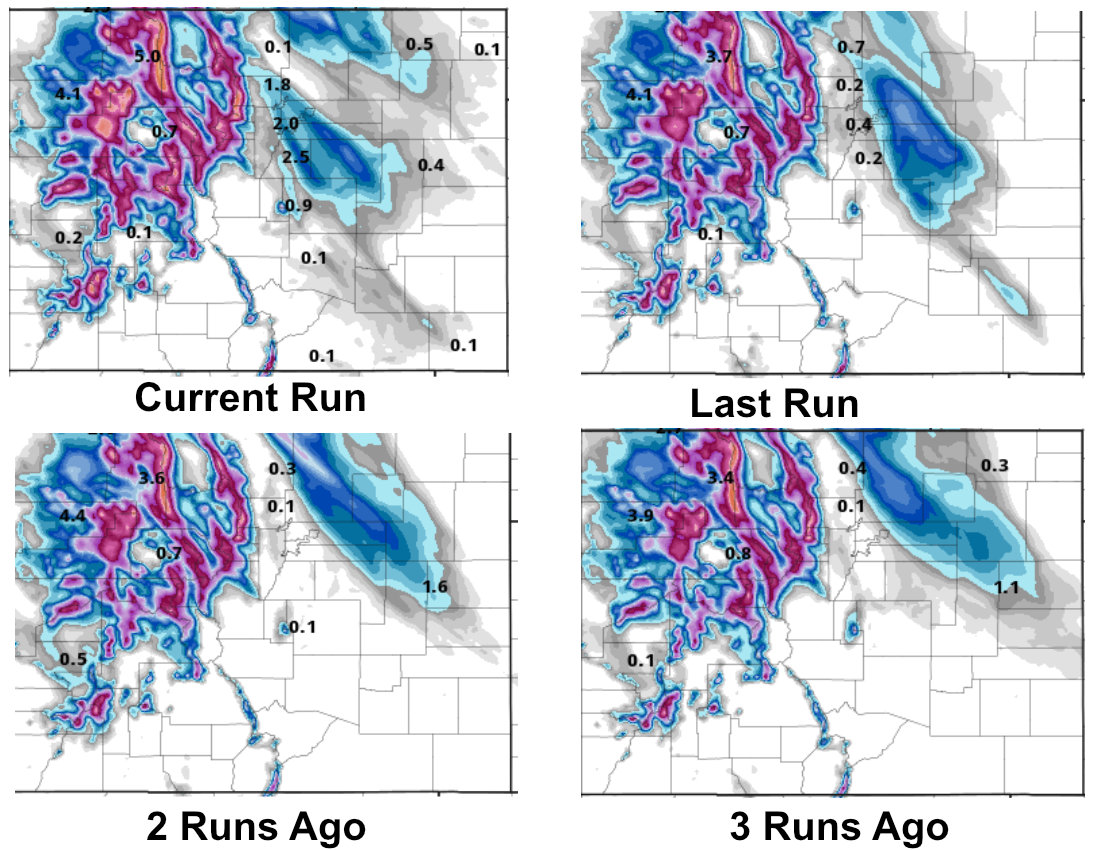
Nam3K total snowfall through Friday PM – current run through current run – 4
Here’s a look at the Nam3K over the past 4 or so model runs. Notice it can’t agree on where the heaviest band of snow is, how strong/intense it is or even on the timing. The overall trend has been to shift that energy southwards towards the Palmer Divide, but that still doesn’t give us confidence in a decent snow event in our area because none of these models have been consistent.
For what it’s worth, the GFS wants to shift that snow band Southwards as well.
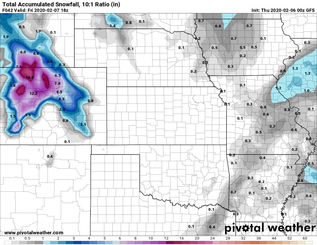
GFS total snowfall through Friday late morning
Notice the GFS wants to keep snow hugging urban corridor a bit better and is filled in. I’m not sure I buy any of this right now, it shows a similar trend to the NAM but with lower resolution; this model is not great on picking up minute details so that is one disadvantage. The other thing to recognize is the GFS has overdone snowfall estimates consistently on nearly every storm this year.
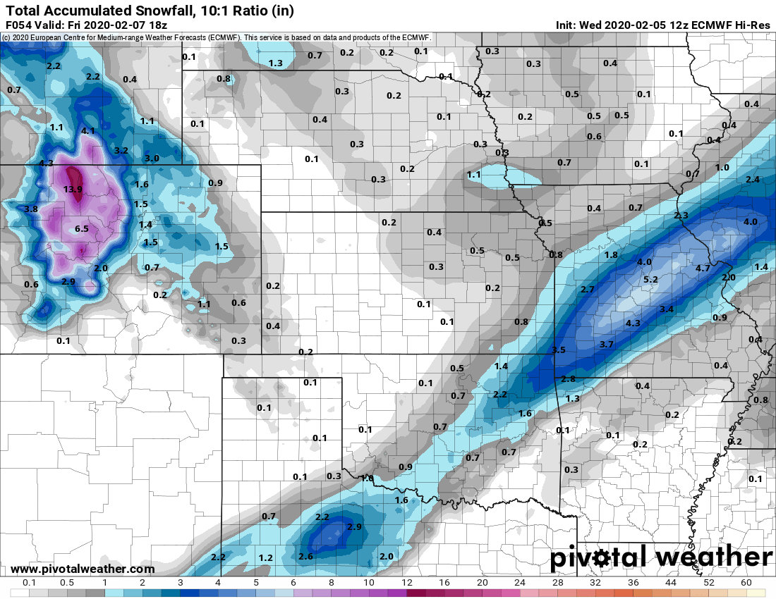
Euro total snowfall through Friday late morning
The Euro continues to not be excited at all about this storm East of the Continental Divide. It shows evidence of banding but does not bring intense lift with those bands across the mountains and onto the plains. This model is one to definitely keep an eye on as it does and has done well with winter storms all year. Not only that, but it has been incredibly consistent about this storm being a big dud for Eastern Colorado.
Here’s What We Know… In a Nutshell
- An intense snowfall band looks likely
- Snowfall rates under this band could approach 2 inches per hour
- Any areas caught under this snow band for any decent duration will have to contend with heavy snow, low visibility and hazardous driving conditions (remember the snow squall warnings we had recently!)
Here’s What We Don’t Know
- Where does this snow band set up (if at all?)
- Does it anchor in one place or does it move quickly? This will mean all the difference in how much snow areas see…
- When does it set up?
- Will it shift Southwards towards the Palmer Divide?
Wrapping It Up
I want everyone to remember a couple of key points about a storm like this:
- Nearly impossible to predict with any decent degree of accuracy
- Areas under this snow band will see significant amounts of snow over a very narrow geographic area
- Odds are low (as of this writing) that band will not impact the Palmer Divide, but there is enough of a trend in model data and enough uncertainty in the overall forecast that I’m slightly concerned about a shift Southwards
- If the forecast changes it will do so very close to the storm’s arrival. Any changes to the snowfall forecast along the Palmer Divide will not give us a lot of lead time.
Be prepared for snow Thursday night and Friday morning. All we can say for sure is plan and be prepared for this just in case. It won’t be a major “blizzard” type storm and only certain areas will see heavy snow. If that band shifts South along the Palmer Divide, be prepared for tough driving conditions for a period of time under that band.
All we can do is stay heads up on this storm right now. I’ll have more updates through the day Thursday. Stay tuned!
