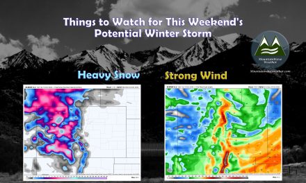
Hopefully everyone is having a great weekend, I took the quiet weather of Saturday to take a day off from social media and weather updates… much needed after the rapid-fire pace of storms last week. Now, with the batteries re-charged a bit, it’s time to take a look at what the next storm system is shaping up to look like and discuss a few details:
Weather Alerts
Winter Weather Warnings and Advisories are mainly confined to the mountains as of this post. The strong storm system forming to our West is transporting large amounts of moisture in from that area and with strong lifting due to upslope on the Western sections of the Continental Divide it means many of the mountain areas will see significant snow over the next 24-48 hours
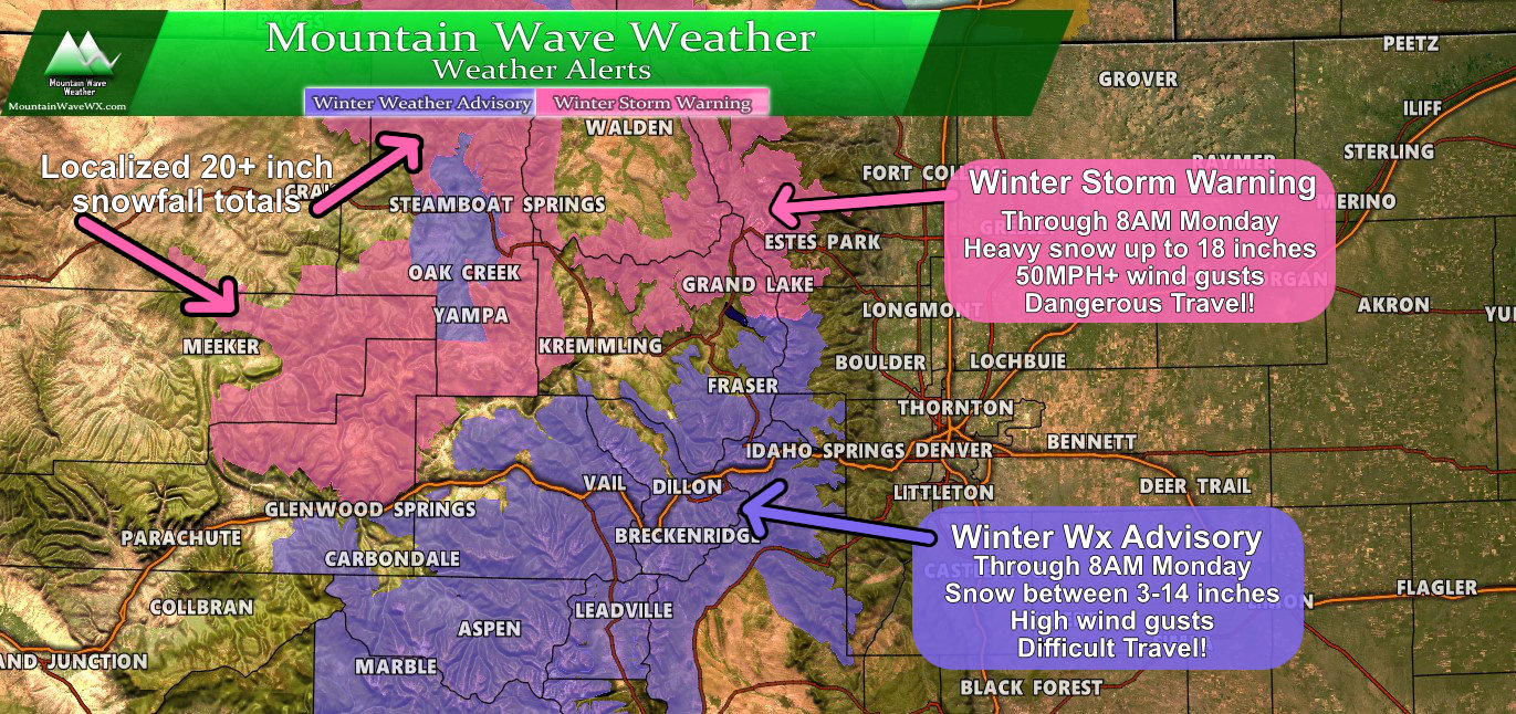
CO weather alerts as of 10AM 2/16/2020
Be advised, if you are travelling to/from the mountains on Sunday evening or Monday at all… we expect there to be significant travel impacts due to avalanches, road closures, accidents, etc… plan on being stuck in traffic for several hours and be prepared in case you are stranded in your car. During Winter Storm Warnings a winter survival kit should always be in your car!
Let’s take a look closer to home in regards to our next storm system…
Storm Discussion (Impacts/Timing/Hazards/Trends)
Timing
- Monday (morning and daytime)
- Spotty snow showers are possible during the daytime but overall any accumulation will be light. I’d put the chance of seeing snow during the morning/daytime hours around 20-30% on Monday. We don’t expect impacts to the Monday morning commute.
- Monday Night
- Snow showers look more likely after 6PM… given the spotty nature of how the snowfall looks to start, some areas may not see snow until later.
- Shallow upslope will favor raised terrain along the front range. This means the areas along the base of the foothills and along the Palmer Divide should see snow at first.
- Snow showers fill in through the night Monday and into Tuesday morning
- We will watch for a possible impact to Monday evening commute if the storm arrives early, but right now we don’t anticipate anything more than light impacts to the Monday evening drive (stay tuned in case this looks to change, we’ll keep an eye on it)
- Tuesday Morning
- If we see any impact due to snow on the drive, Tuesday morning would be the one most likely.
- Areas that see heavier snow could have icy/snowpacked roads
- Snow continuing through the morning hours could make things slick
- Expect a slower drive Tuesday morning at this point (we will forward any changes if needed)
- Tuesday Afternoon
- Show should gradually end in the late morning/early afternoon hours
- Depending on how much snow falls, be prepared for an impact Tuesday evening on the commute… that impact looks light with the data we are currently seeing
- Wednesday
- Looking at a chance of another storm system with accumulating snowfall… details will be coming later on this system
*Forecast is fluid, keep an eye on our forecasts and we will be sure to pass along any changes if things change!
Snowfall Amounts
- See below for more specific details
- While this storm has more of an upslope component, it is weak. We can see pretty strong westerly flow aloft in a lot of the models… which means “banded” pockets of heavy snow could happen in very select locations
- This makes the snowfall forecast very tricky with a high level of uncertainty! Stay tuned for details and changes!
Impacts
- Wet/slushy and icy roads are all impacts possible with this storm
- I’d expect these impacts to favor higher terrain areas South and West of Denver
- Banded snowfall means these impacts could occur anywhere heavier snowfall bands set up so be prepared!
Expected Snowfall
Palmer Divide

Forecast Snow through Tuesday PM – Update 2/16/2020 10:30AM
Discussion
One of the biggest questions I get from folks is “should I cancel plans on this date and this time?”
I can’t really tell you that, my idea of unsafe conditions is most likely a lot different from yours (I storm chase every spring)
What I can say is this storm doesn’t look “major” with any of the data I can see as of this morning. More than anything it looks like it could just be an inconvenience for travel especially later Monday and Tuesday morning.
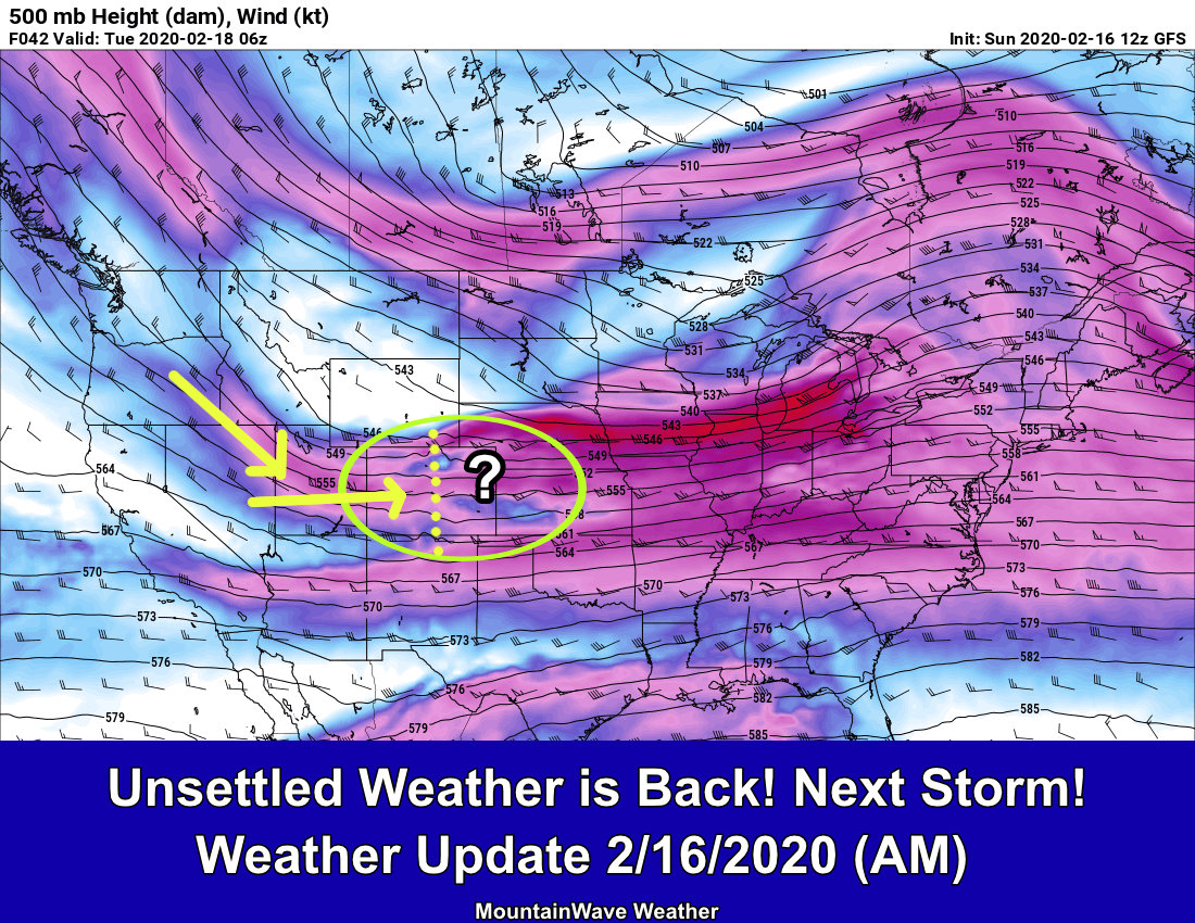
The Wild Card?
An interesting set up with this storm, in the graphic I’ve posted below you can see 500mb (upper air pattern) showing strong West to East flow over Colorado. This throws a money-wrench in a traditional forecast because it means the dreaded “banded snowfall” set up is again possible with this storm. I’ve said this dozens of times but when you have setups like this:
- You don’t know where/if the heavy snowfall bands set up
- You don’t know how strong they will be
- You don’t have a good grasp on specific timing
In short, the uncertainty level in any forecast like this is medium/high.
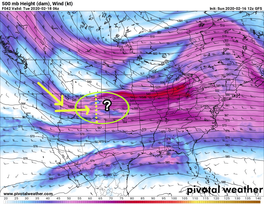
500mb upper air forecast by the GFS model for late Monday night
One More Thing…
One thing we have to closely watch with a storm like this is that when flow is more westerly like this, the atmosphere can have a tough time transporting that moisture across the Continental Divide. I’ve seen storms like this that bust pretty hard when the winds set up perfectly but there’s no moisture to squeeze out. This will be something we will be watching closely.
What about that other storm with snow bands that went nuts and over-performed?
Larger “banded” snowfall overperforming storm from a couple of weeks ago…
Recall that was more Northwesterly flow and was able to better transport moisture up North, away from the mountains and into Eastern Colorado. This storm may have a much tougher time doing that based on the more westerly flow. Mountains usually tend to trap a lot of that moisture.
Quick Summary
So far I’m not sold on much with this storm, the setup is weak, the storm remains very unorganized and a more westerly flow aloft means moisture transport won’t be ideal. As always though, when you have a strong jet overhead and a cold front pushing in upslope conditions from the North anything can happen!
Right now, we will keep an eye on it and be sure to pass along any updates!
