While at this point in time our last storm was trending upwards significantly in snowfall among the weather models; this storm is very much doing the opposite. Not to say, it can’t swing back, but it’s looking more and more probable that this storm won’t hold a candle to the last one we had.
Here’s the latest details as of this morning’s data:
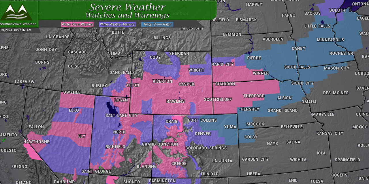
Winter Weather Highlights
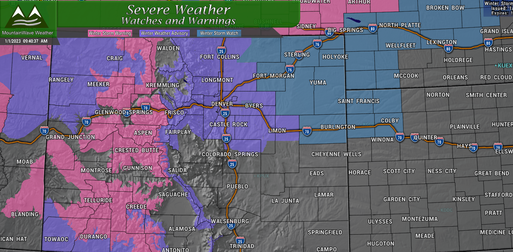
Winter Storm Warning
Areas: Elkhead, Park and Flat Top Mountains, Gore Mountains, central mountains valleys, Grand and Battlement Mesas, Elk and Sawatch Mountains, Southwest Colorado and San Juan Mountains
From/to: In effect now through Monday evening
What: High snow accumulation and winds gusting up to 40 mph
Impacts: Combination of heavy falling snow and gusty winds will make for dangerous travel conditions.
Winter Weather Advisory (Mountains)
Areas: South and Southeast Grand, West Central and Southwest Boulder, Clear Creek, Summit counties, North Park and West Park (includes I-70 corridor East of Vail and West of Georgetown
From/to: In effect now through late Monday night
What: Moderate snow accumulation and winds gusting to 55mph
Impacts: Combination of falling snow and gusty winds will make for difficult travel conditions and low visibility
Winter Weather Advisory (Central Colorado)
Areas: South and Southeast Grand, West Central and Southwest Boulder, Clear Creek, Summit counties, North Park and West Park (includes I-70 corridor East of Vail and West of Georgetown
From/to: 7PM this evening (Sunday) through 8PM Monday
What: Ice accumulation initially due to freezing rain, snow accumulation amounts between 2-6 inches with areas North of the Palmer Divide seeing the highest snowfall
Impacts: Ice accumulation on roadways and falling snow will make for difficult travel conditions
Winter Storm Watch
Areas: Northeastern Colorado (includes Fort Collins and Greeley)
From/to: Late Sunday night through late Monday night
What: Freezing rain, heavy snow accumulation and winds gusting to 35mph. Potential for heavy snow, travel conditions may become difficult.
Snowfall Forecast
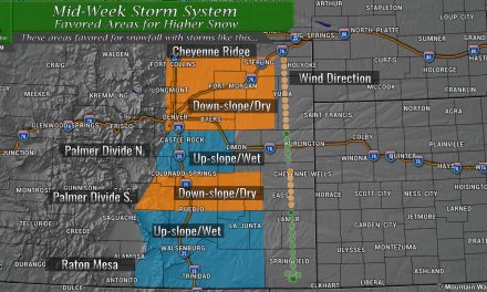
Palmer Divide
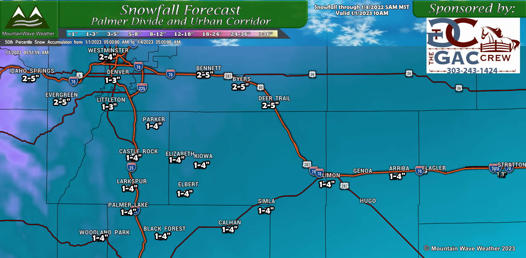
Snowfall ranges have been reduced significantly across the Palmer Divide as models continue to not only shift the storm North… but also shift winds to a Southerly/Southeasterly component fairly soon after the storm’s arrival. For areas along the Palmer Divide, this is a downsloping wind and is not favorable for generating significant snow amounts for that area. I’ve left the spreads a bit wide (1-4″ instead of 1-3″ and such) just incase we see a bit longer upslope component or temperatures allow for more snow to accumulate.
That being said, with the data coming in this morning, many areas may struggle to reach 1 or 2 inches if these trends continue. If that happens, snowfall expectations may be reduced further in an later update.
Northern Colorado
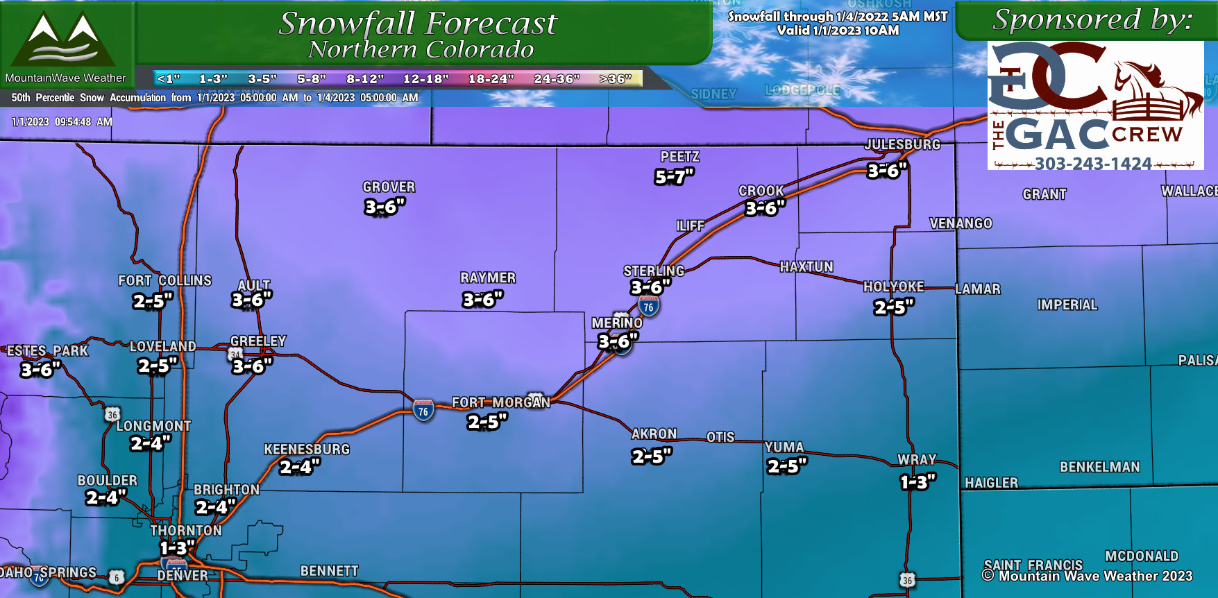
Not a whole ton of changes to Northern Colorado from our last update, mainly the heavier snow shifted a bit further North and Northeast. The areas up across the border to Wyoming will see the best shot at heavier accumulating snow. There is still a bit of uncertainty however, that is likely why this area is still in a Winter Storm Watch and has not upgraded to anything else yet.
Southern Colorado
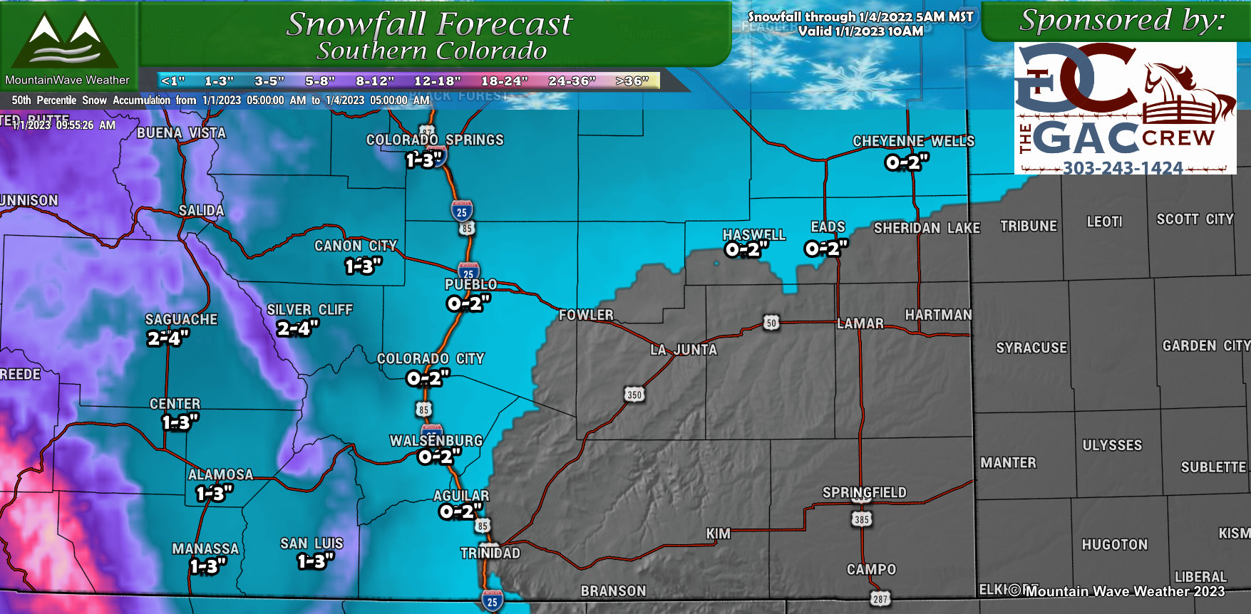
No real changes on Southern Colorado for snowfall expectations, this storm will have more of a Northern track so it will not affect Southern and Southeastern Colorado much from a snow standpoint. Do expect areas of gusty winds/blowing dust however.
Mountains
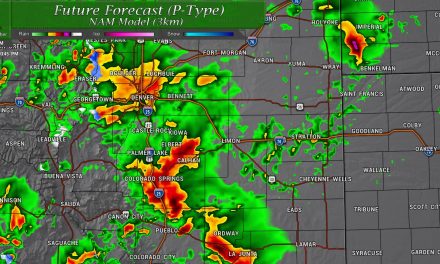
The messaging for the mountains has not changed… heavy snow will be likely late Sunday through most of the day Monday. The overall, storm total amounts have not changed:
You can see mountain snowfall totals and travel impacts with our last post.
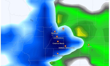
Alert! Freezing Rain/Ice Accumulation Expected!
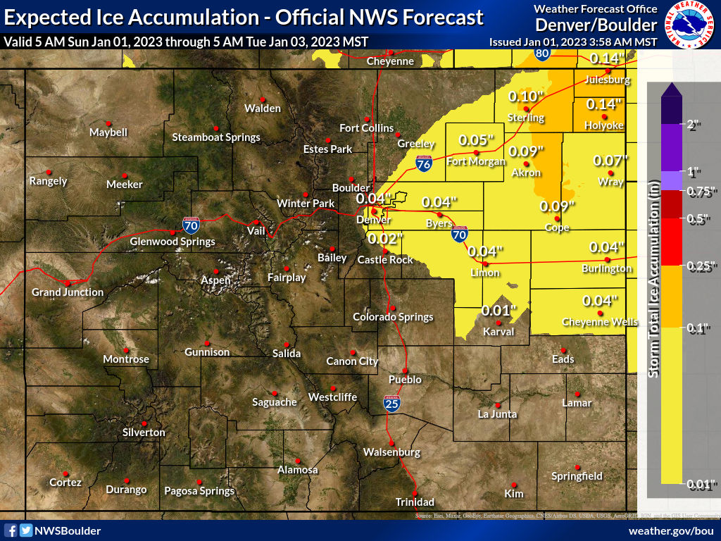
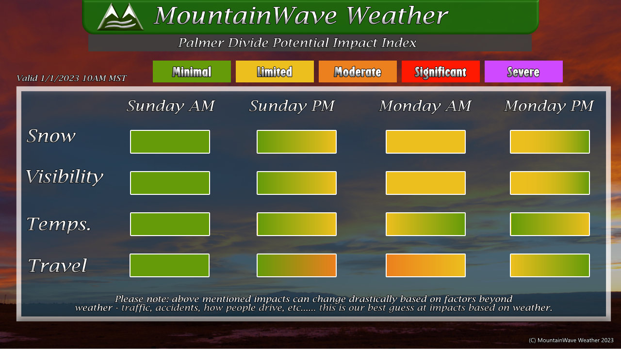
Some areas along the Urban Corridor and Palmer Divide (along with Eastern and Northeastern Colorado) may see freezing rain at the start of this storm. This could form layers of ice on the roadways, making travel a bit sketchy. Additionally, once the snow moves in, you will see snow accumulation on top of a layer of ice. I’ve upgraded the storm impact index below to account for at least moderate travel impacts due to ice initially and then snow.
Forecast Bulletpoints (Quick Need-To-Know Information)
Palmer Divide/Urban Corridor/ Metro Denver
- Storm moves in between 6-9PM
- Freezing rain possible initially, then switching to snow
- Ice accumulation and snow could make for slick roads
- Low to moderate impacts expected with the storm – significant/major impacts not anticipated
Mountains
- Lull in snowfall on Sunday, this could last to Monday morning (now due to the shift in track and timing with this storm)
- Heavy snow develops again by Monday morning
- Heavy snow lasts all day Monday into Tuesday afternoon
- During periods of heavy snowfall… travel could be very difficult in many areas and dangerous in some
Best Travel Day?
- Sunday!
- Wednesday and Thursday
Summary
Happy New Years and welcome to 2023! The forecast is continuing to evolve, however it is looking more like a nuisance/headache storm for most of us in Eastern Colorado, rather than a big snow/impact producer like the last.
With that, I may post more forecast updates if things change drastically, otherwise you may not see much until later this evening when the storm is already here. It’s a holiday so I plan on taking some time!
Have a happy and safe New Years day!
