Ag and Ranching Interests: Have all preparations for cold weather and moderate/heavy snow completed by 3PM Tuesday afternoon
Models stayed pretty consistent overnight, which gives us better confidence about this storm. I did make a few adjustments to the snowfall forecast to bring things better in line along with dragging some of the higher snowfall totals a bit further North. Here’s the latest details with the data as of this morning:
WINTER WEATHER HIGHLIGHTS
Winter Weather highlights.
Details below:

Winter Storm Watch has been upgraded across the board this morning, here’s the details on the various watches, warnings and advisories:
…WINTER STORM WARNING IN EFFECT FROM 5 PM THIS AFTERNOON TO
MIDNIGHT MST WEDNESDAY NIGHT…
* WHAT…Heavy snow expected. Total snow accumulations between 5 and
10 inches. Winds gusting as high as 45 mph.
* WHERE…The Southern Front Range Foothills, and Castle Rock.
* WHEN…From 5 PM this afternoon to Midnight MST Wednesday Night.
* IMPACTS…Roads will likely become slick and hazardous. Travel
could be very difficult. The hazardous conditions could impact the
Tuesday evening and Wednesday morning commutes.
…WINTER STORM WARNING IN EFFECT FROM 8 PM THIS EVENING TO 8 PM
MST WEDNESDAY…
* WHAT…Heavy snow expected. Total snow accumulations of 6 to 13
inches. Winds gusting as high as 45 mph.
* WHERE… Wet Mountains and Wet Mountain Valley and Fremont,
Pueblo, Huerfano, and western Las Anmias Counties.
* WHEN…From 8 PM this evening to 8 PM MST Wednesday.
* IMPACTS…Travel could be very difficult. Areas of blowing snow
could significantly reduce visibility. The hazardous conditions
could impact the morning or evening commute.…WINTER WEATHER ADVISORY IN EFFECT FROM MIDNIGHT TONIGHT TO
MIDNIGHT MST WEDNESDAY NIGHT…
* WHAT…Snow expected. Total snow accumulations between 3 and 7
inches. Winds gusting as high as 35 mph.
* WHERE…Denver, Boulder, and eastern Adams and Arapahoe counties.
* WHEN…From Midnight tonight to Midnight MST Wednesday Night.
* IMPACTS…Snow covered roads will make travel hazardous. Plan on
slippery road conditions. The hazardous conditions could impact
the Wednesday morning and evening commutes.
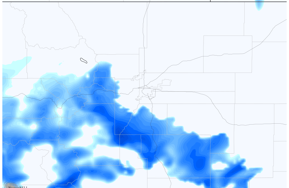
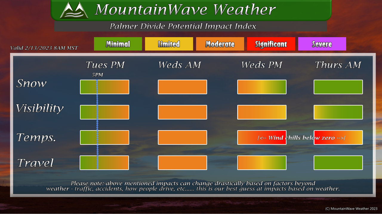
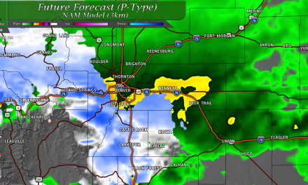
LATEST SNOWFALL FORECAST AND DISCUSSION
Palmer Divide/ Denver Metro Area

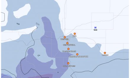
Overnight the main trend was to solidify the Palmer Divide as the bullseye for this storm, snow amounts have been slightly increased across the region due to model confidence and agreement. I will note that most models have the lower ends of these ranges (Castle Rock for instance is consistently in the 6-7″ range) but there will be several localized areas that see amounts up to 10″. Due to the snow and wind, visibility will be poor and travel will likely be impacted across the Palmer Divide tonight, expect road closures by morning in some areas.
Northern Colorado
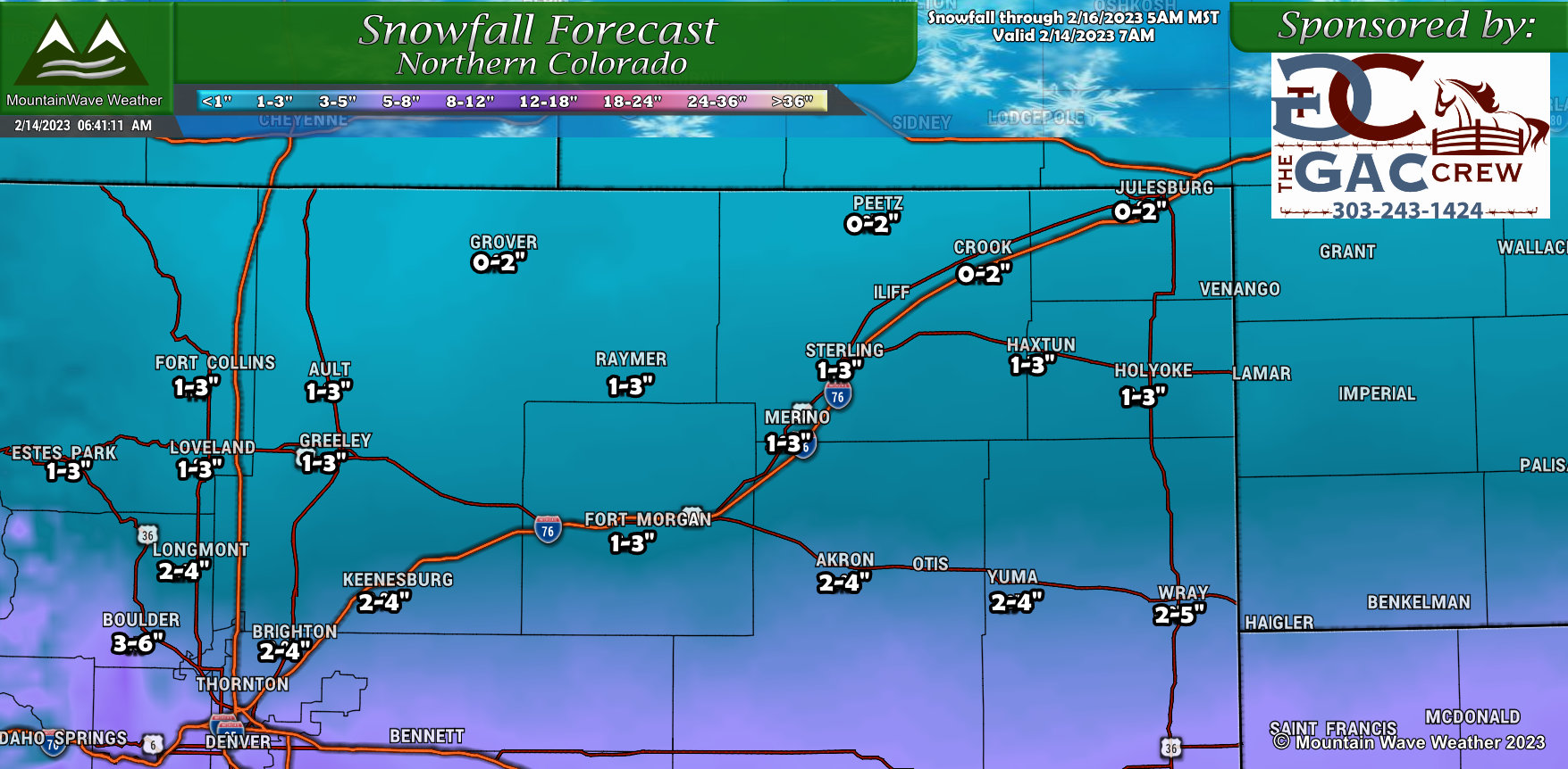
Few major changes to Northern Colorado, this storm has shifted a bit further North but most of the impacts look to stay around Denver and to the South and East.
Southern Colorado
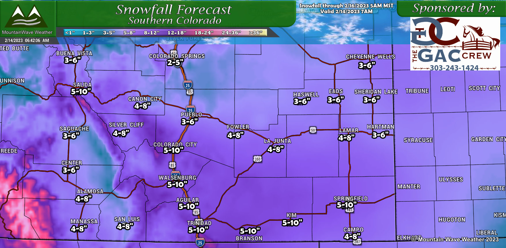
Southern Colorado is still favored for this storm, minor adjustments to the forecast snowfall amounts but overall things remain the same. Windy conditions and snow will make for travel impacts late tonight and into tomorrow morning – expect road closures especially out East and difficult travel conditions along the I-25 corridor.
Southwestern Colorado
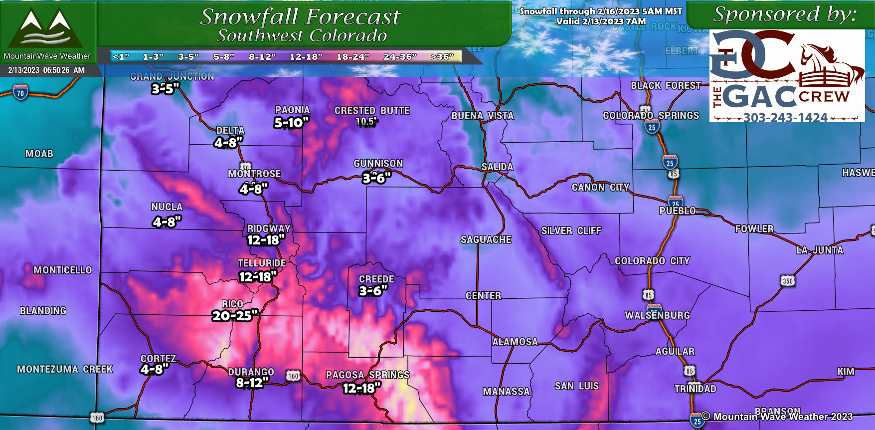
No changes to Southwestern Colorado, they will see plenty of snow!
TIMING AND IMPACTS
Few changes to our thinking on timing, if anything it looks like the heavier snow waits a bit later until late in the evening rush or after. Not too worried about Tuesday evening travel conditions earlier in the evening, expect things to deteriorate as we go later into the evening and overnight hours.
*No changes here*
Timing
- Snow starts between 6-9PM
- Winter Storm Watch in effect at 5PM
- Road conditions may deteriorate rapidly later in the evening, overnight and morning hours Wednesday
- Storm will move out later Wednesday late afternoon/evening, snow and wind will continue through most of the day until then
Impacts
- Moderate to heavy snow accumulation is possible
- Strong winds up to 40-50mph
- Some areas may experience road closures due to blowing snow/poor visibility/dangerous conditions
- Very cold temperatures possible Wednesday night and into Thursday morning (temps near zero, wind chills below zero)
- Expect moderate impacts to travel as a minimum across the primarily the Palmer Divide, Southeastern and Southern Colorado. Some localized areas of Significant impacts are possible – keep this in mind when traveling. Probably a good idea to be off the roads by late this evening especially East of the I-25 corridor along the Palmer Divide and East of Denver
SUMMARY
So far all aspects of this storm look on track. We will still be forecasting through the day Tuesday so make sure to stay tuned for any additional updates. In the meantime, have all cold weather/heavy snow preparation finished by late Tuesday afternoon.
Stay tuned for any further information!
