Here’s a quick recap of our late Spring snow storm we experienced. Seeing such high snowfall amounts this late in May is a bit rate, but snow storms themselves are not that uncommon for this time of the year. Still, getting the snow to accumulate this much is tough; the odds are definitely against it between the warm ground, high sun angle and ample melting.
Below I have a map and forecast verification discussion on how I did. Let me know what you think!
Freezing Conditions Expected Tonight
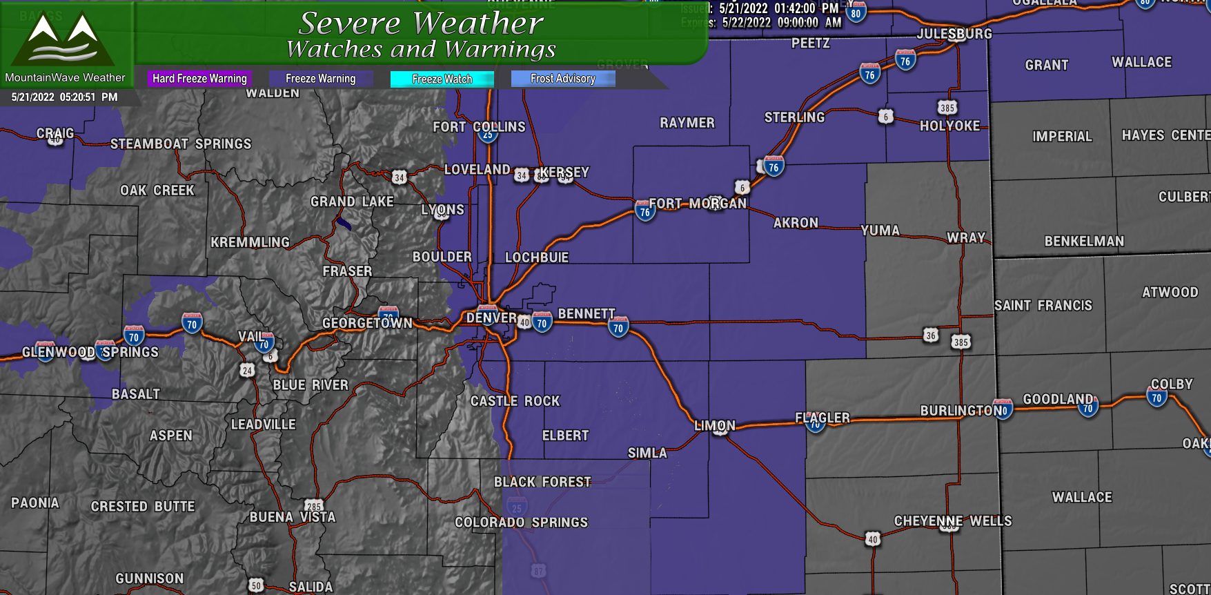
A Freeze Warning has been issued for tonight, here’s the details:
…FREEZE WARNING IN EFFECT FROM 9 PM THIS EVENING TO 8 AM MDT
SUNDAY…
* WHAT…Sub-freezing temperatures as low as 29 expected.
* WHERE…Portions of east central, north central, and northeast
Colorado.
* WHEN…From 9 PM this evening to 8 AM MDT Sunday.
* IMPACTS…Frost and freeze conditions could kill crops, other
sensitive vegetation and possibly damage unprotected outdoor
plumbing.
Forecast Verification
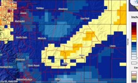
Very happy with how this forecast went from a snowfall perspective. Every area I highlighted along the Palmer Divide reached its forecasted range, even down towards the springs, Black Forecast and the areas around Calhan and Simla behaved as expected. Some of the misses included Palmer Lake underperforming a bit, but I wonder a bit as only one official measurement was listed.
Additionally, a few areas around Evergreen also underperformed but there were several measurements within our forecast range as well.
Finally we go to Denver, most of those areas underperformed the forecast, but I won’t get too perturbed by that because I made it clear that area had my lowest confidence in reaching the forecast snowfall range. These areas in lower elevations struggled to cool the ground enough to accumulate much snow; I thought that temperature would be fickle so those areas performed pretty much as expected.
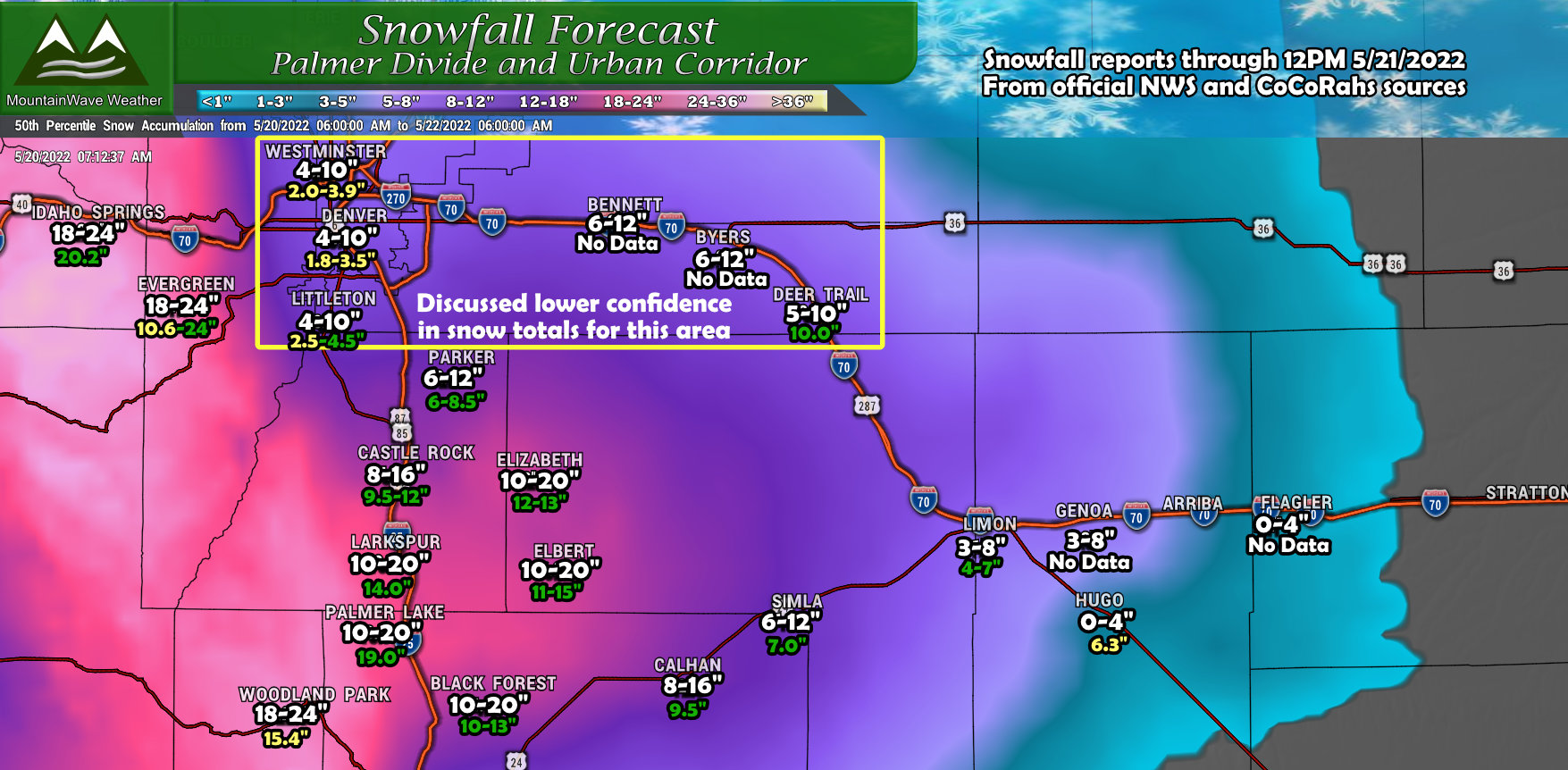
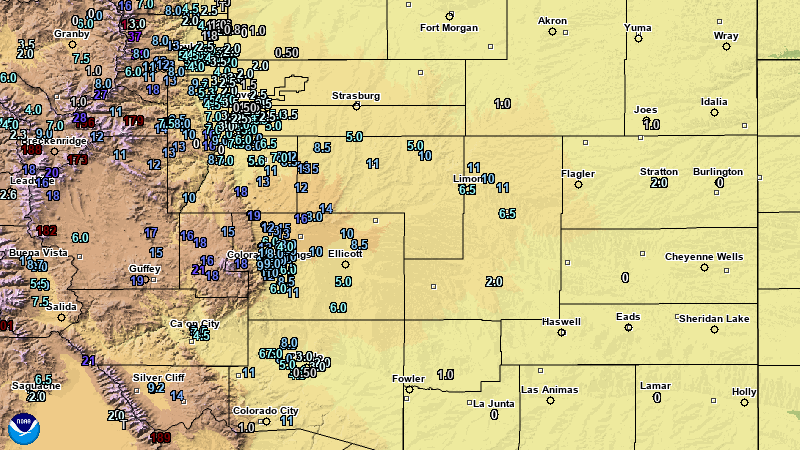
In the map above for the snowfall amounts I tried to include a range if there were multiple reports for that city.
Overall: very happy with what was a very tricky, late season, spring snow storm forecast!
Final Thoughts
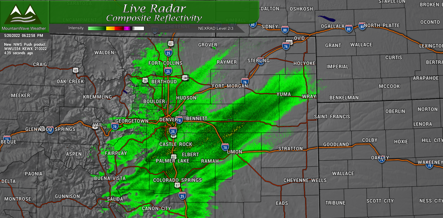
We also mentioned 2 lifting mechanisms that would come into play, both of those panned out pretty perfectly. The upslope established with Easterly and Northeasterly winds as the storm moved through but we also saw lift from the jet as it moved overhead. Due to the Conditional Symmetric Instability we saw heavy snow bands set up and sit along the Palmer Divide for a good portion of this storm. This really helped those areas reach the higher snowfall totals.
Radar snapshot below taken around 6PM shows the stronger/heavier snow bands across the Palmer Divide.
Other Locations Snowfall Totals
Here’s some snowfall totals for some other locations around the state. These appear to be updated so as of this afternoon so you shouldn’t see anything too crazy in there.
Source: KDVR Fox 31 Denver
- Air Force Academy: 13 inches
- Allenspark: 12 inches
- Alma: 17 inches
- Arvada: 8.1 inches
- Aspen Park: 15.5 inches
- Aspen Springs: 18.5 inches
- Aurora: 7 inches
- Bailey: 12.7 inches
- Bennett: 4.5 inches
- Bergen Park: 12 inches
- Berthoud: 2.7 inches
- Berthoud Pass: 15.6 inches
- Bellvue: 1.1 inches
- Beulah: 13.5 inches
- Black Hawk: 11 inches
- Black Forest: 16 inches
- Blende: 10 inches
- Blue River: 15.6 inches
- Blue Valley: 20.2 inches
- Boulder: 8.3 inches
- Brainard Lake: 10.8 inches
- Breckenridge: 18.6 inches
- Brookvale: 11.5 inches
- Broomfield: 5.2 inches
- Buckley Air Force Base: 5 inches
- Byers: 5 inches
- Cameron Pass: 12 inches
- Campion: 2 inches
- Cañon City: 10 inches
- Carter Lake: 5.7 inches
- Cascade: 14 inches
- Castle Pines: 9.3 inches
- Castle Rock: 14.5 inches
- Castlewood Canyon: 17 inches
- Cedar Point: 10.8 inches
- Cheesman Reservoir: 10 inches
- Cherry Creek Reservoir: 5 inches
- Cherry Hills Village: 5 inches
- Colorado Springs: 12 inches
- Columbine: 7 inches
- Commerce City: 2.5 inches
- Conifer: 13.5 inches
- Cope: 2.1 inches
- Copper Mountain: 16.8 inches
- Crescent Village: 13 inches
- Cripple Creek: 20 inches
- Crook: 8 inches
- Denver International Airport: 2.3 inches
- Downieville: 12 inches
- Echo Lake: 21.6 inches
- Edgewater: 3.5 inches
- Elbert: 15 inches
- Eleven Mile Canyon Reservoir: 15 inches
- Elkdale: 6.6 inches
- Elizabeth: 14 inches
- Englewood: 2.3 inches
- Erie: 3.9 inches
- Estes Park: 14 inches
- Evergreen: 10.3 inches
- Federal Heights: 6.2 inches
- Firestone: 1 inch
- Florissant: 7 inches
- Floyd Hill: 24 inches
- Fountain: 10 inches
- Foxfield: 6.1 inches
- Franktown: 9 inches
- Fraser: 4 inches
- Genesee: 10.6 inches
- Genoa: 10.3 inches
- Georgetown: 11.3 inches
- Glendevey: 12 inches
- Golden: 14.5 inches
- Gore Pass: 5.7 inches
- Gould: 22.8 inches
- Grand Lake: 11 inches
- Grant: 10.5 inches
- Greenland: 17.5 inches
- Greenwood Village: 5 inches
- Hahn’s Peak: 6 inches
- Heeney: 8.2 inches
- Highlands Ranch: 8.5 inches
- Horsetooth Mountain: 1.4 inches
- Howard: 28.5 inches
- Hugo: 8 inches
- Hygiene: 4 inches
- Idaho Springs: 20.2 inches
- Jamestown: 12.1 inches
- Karval: 2 inches
- Kassler: 16.4 inches
- Ken Caryl: 17.7 inches
- Kiowa: 14 inches
- Kinikinik: 6.2 inches
- Kittredge: 12.1 inches
- Kremmling: 8 inches
- Lafayette: 5.5 inches
- Larkspur: 6 inches
- Leadville: 9.8 inches
- Limon: 7.2 inches
- Littleton: 4.3 inches
- Lochbuie: 1 inch
- Lone Tree: 9.2 inches
- Longs Peak: 15.6 inches
- Longmont: 5 inches
- Louisville: 6.5 inches
- Loveland: 0.5 inches
- Loveland Pass: 14.4 inches
- Lyons: 9.5 inches
- Manitou Springs: 9 inches
- Marshall: 8.1 inches
- Mead: 0.8 inches
- Meeker: 5.5 inches
- Monument: 16 inches
- Morrison: 8 inches
- Mount Audubon: 15.6 inches
- Mount Zirkel: 9.6 inches
- Mountain View: 4 inches
- Nederland: 15.5 inches
- Niwot: 3.7 inches
- Northglenn: 4.1 inches
- Oak Creek: 5.5 inches
- Palmer Lake: 19 inches
- Parker: 6.1 inches
- Parshall: 6.3 inches
- Penrose: 9 inches
- Perry Park: 20 inches
- Pennock Pass: 0.6 inches
- Peterson Air Force Base: 10 inches
- Phippsburg: 5 inches
- Pinecliffe: 13.7 inches
- The Pinery: 8.5 inches
- Pinewood Springs: 9.6 inches
- Piñon: 5.5 inches
- Pleasant View: 6 inches
- Ponderosa Park: 13 inches
- Pueblo: 6.8 inches
- Pueblo West: 7.5 inches
- Rand: 14.4 inches
- Rocky Flats: 10 inches
- Red Feather Lakes: 2 inches
- Rollinsville: 14.1 inches
- Rosita: 13.8 inches
- Salida: 9 inches
- Salida: 9 inches
- San Isabel: 11 inches
- Sawpit: 1.9 inches
- Shadow Mountain: 17.5 inches
- Shaffers Crossing: 6 inches
- Sheridan: 6 inches
- Simla: 11.9 inches
- Silverthorne: 4.8 inches
- Spanish Peaks: 12 inches
- Spicer: 4.8 inches
- St. Mary’s Glacier: 18 inches
- Steamboat Springs: 6 inches
- Strasburg: 2.3 inches
- Sunshine: 13.5 inches
- Superior: 5.8 inches
- Tabernash: 5.5 inches
- Thornton: 1.6 inches
- Tincup: 6 inches
- Todd Creek: 2 inches
- Toponas: 2.5 inches
- Virginia Dale: 3.4 inches
- Walden: 6.1 inches
- Walsenburg: 10 inches
- Ward: 16.8 inches
- Westcliffe: 10 inches
- Westminster: 5 inches
- Wetmore: 13 inches
- Wheat Ridge: 6.3 inches
- White Ranch Park: 16 inches
- Williams Fork Reservoir: 2.5 inches
- Wilkerson Pass: 16.3 inches
- Winter Park: 7.3 inches
- Woodland Park: 16 inches
- Woodrow: 1 inch
