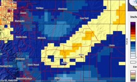
Not a bad little storm we had these past few days. As expected, the snowfall amounts varied widely across the area but as we figured areas in the foothills and South and West of Denver fared the best. Some of those areas saw between 5-10 inches of snow and even some areas up in and around Boulder saw over a foot!
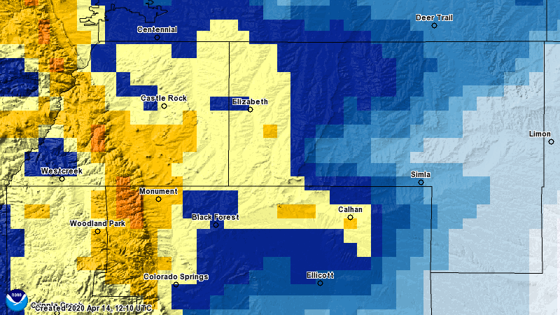
Here's a quick look at the interpolated snowfall map for the past 48 hours
Visually you can definitely see how the higher snowfall amounts lined up across the front range. Along the Palmer Divide the heaviest snow accumulation looked to be West of the I-25 corridor and up into the foothills of Douglas and Teller counties with decent accumulations along the I-25 corridor South of Castle Rock towards the springs.
Here's some pinpoint reports for snowfall:
- Black Forest: 4.2
- Castle Pines: 5.5
- Castle Rock: 4.0
- Colorado Springs: 6.0
- Elbert: 2.0
- Elizabeth: 3.0
- Franktown: 2.7
- Littleton: 6.2
- Lone Tree: 4.2
- Monument: 5.1
- Palmer Lake: 5.5
- Parker: 3.2
Big winners out of this storm:
- Boulder: 17.7
- Estes Park: 8.7
- Eldorado Springs: 19.3
- Nederland: 10.6
- Golden: 12.8
Generally the highest totals were just West of Boulder and Denver in the foothills.
*If you're wondering why the numbers above don't quite match the map; the map tends to blend snowfall totals in large areas where we don't have many reports. In this case, the NWS didn't get a ton of reports from around Parker, Eastern Douglas and Western Elbert counties, but this is pretty typical sometimes.
Another Storm on the Way!
Stay tuned for a post later today detailing our next storm system, it looks to have the potential to bring several more inches of snow with it!
