While we may not know all the little details with the storm brewing out West this weekend, we can say for sure it will be fairly powerful and bring major/significant impacts to those areas that get hit by it.
The major question remains for Colorado, who sees what… how bad does it get… and when does it hit?
While we are still a bit out on this forecast (shorter range, higher resolution models will only start to be in range around Saturday night) I’ll attempt to answer a few questions I’ve heard and update with the latest data.
Saturday/Sunday
In short, Saturday and Sunday will be fairly tranquil, all things considered. Model guidance has high temperatures to around the 50’s for much of Denver and the front range. Highs on Sunday will be a bit warmer with temps maxing out in the upper 50’s to near 60, both nights lows look to be in the low to mid 20’s.
One issue we will be watching for Sunday is the potential for gusty winds, especially South of Denver along the Palmer Divide, towards Colorado Springs and further South towards Pueblo. Due to the stronger winds, warm temperatures and low humidity a Fire Weather Watch is in place for those areas Sunday 11AM to 5PM.
Winds could gust as high as 40MPH and humidity will be around or a bit lower than 10% that makes for critical fire weather conditions.
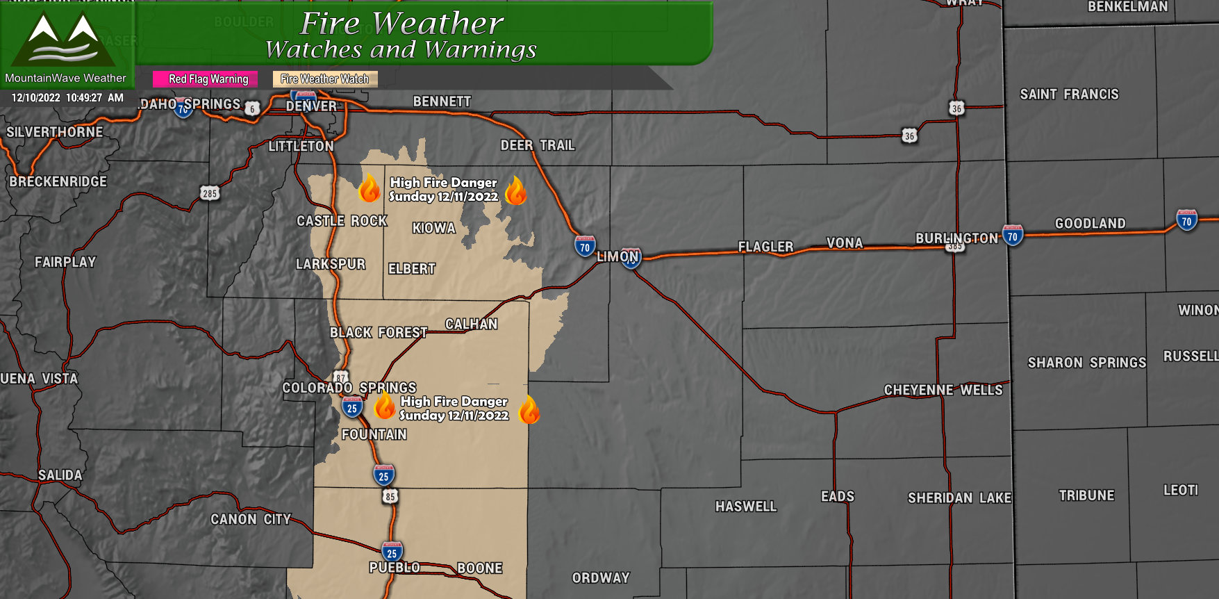
If you live in the watch area, may be best to have things tied down. While the wind won’t be as strong as the storm system last week, it will be breezy enough that lightweight items may decide to take a flight. Have that all completed by early Sunday morning!
Western U.S. Storm – Very Impressive
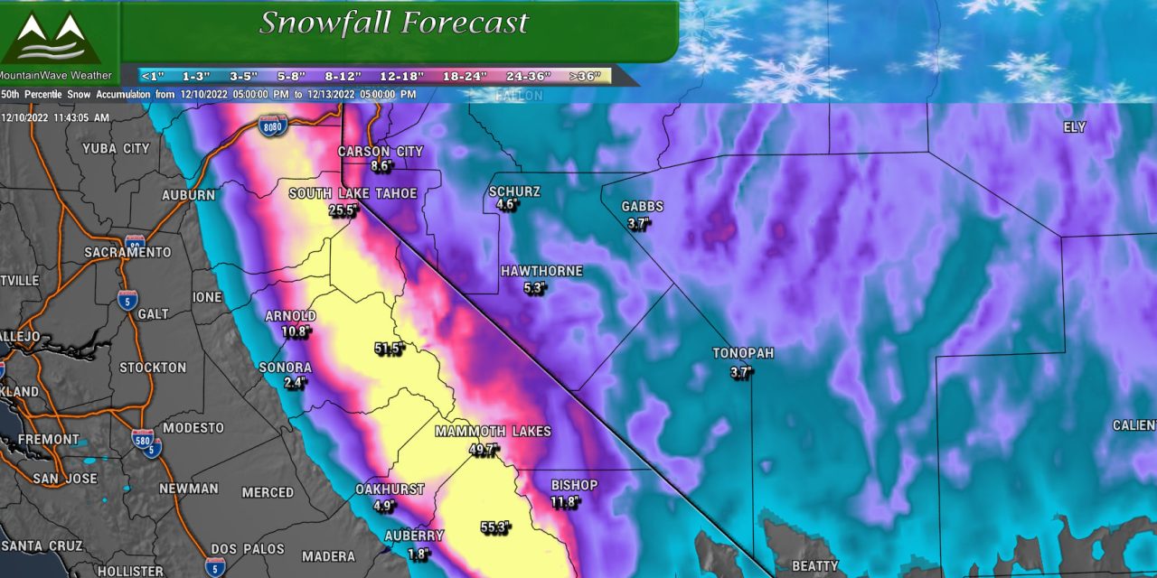
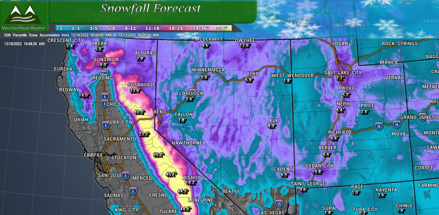
This storm will bring with it impressive amounts of moisture, cold air and wind. If you have any doubt, take a look at some of the forecast snowfall for the mountains in California…
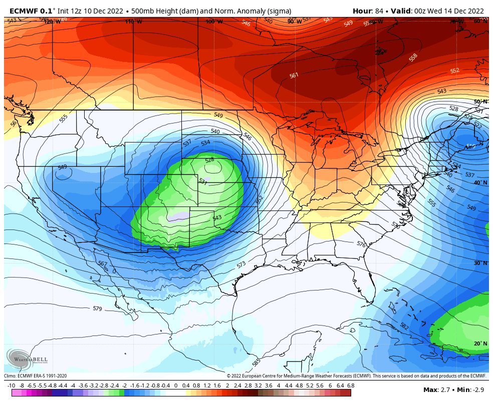
If you take a look at the 500mb height anamolies it becomes apparent how powerful this storm will become as it ejects across Colorado and into the Northern plains.
Forecast Updates
We are still very much in a “wait and see” mode with this storm system… at least for Colorado. For other areas, there is growing confidence for a high impact storm system with heavy snow, high accumulations, strong winds and blizzard conditions.
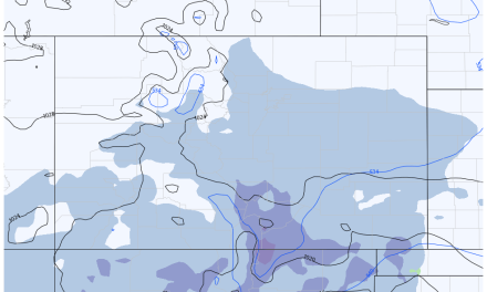
I’ve broken down my thoughts and areas we are watching on the map below…
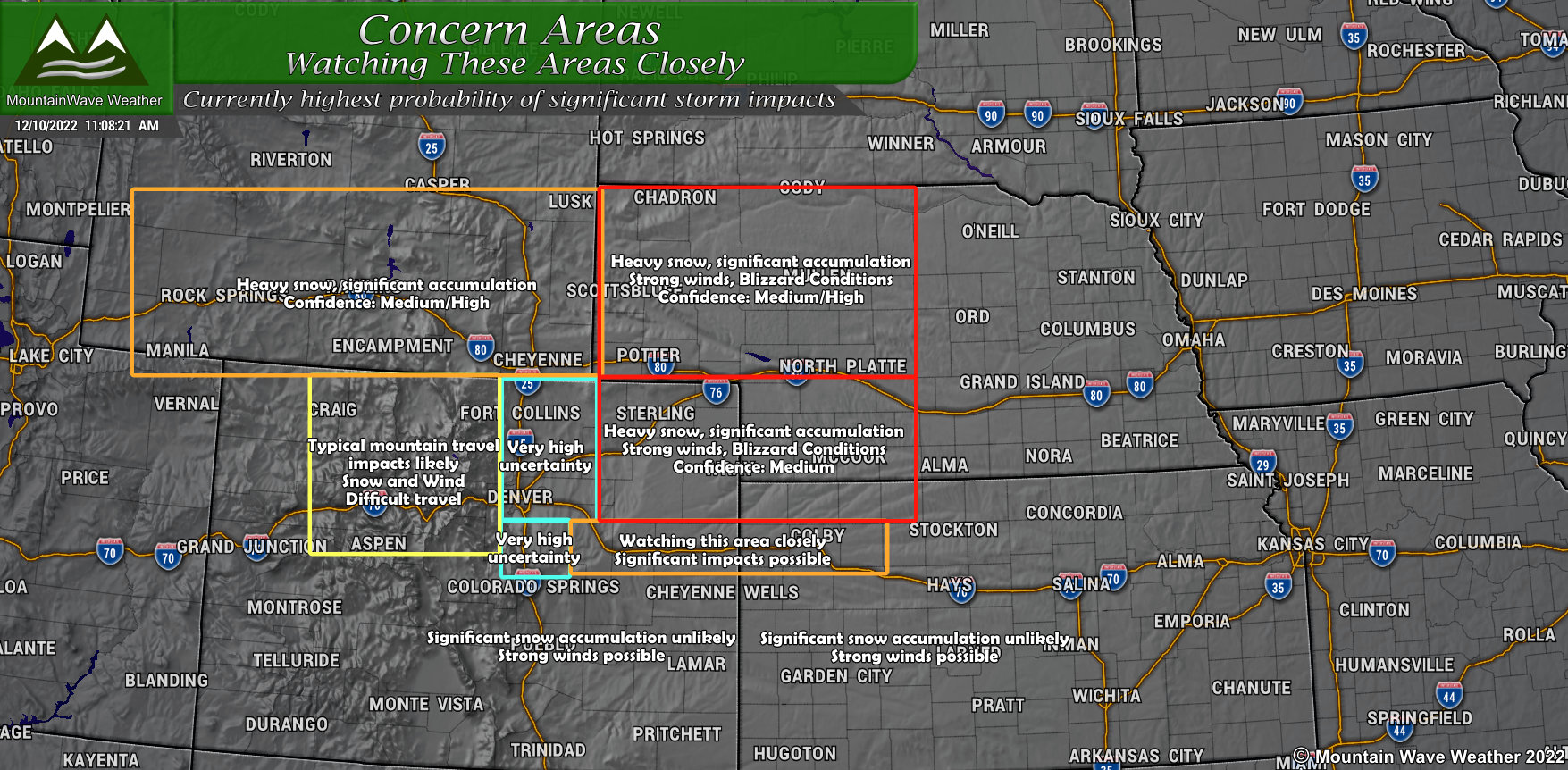
You can click on this image to zoom in
Here’s the highlights:
- The mountains of Colorado look to see decent accumulation of snow with this storm, especially along favored peaks of the Continental Divide. Expect typical winter weather travel conditions up there on Monday and Tuesday.
- Wyoming looks to have decent snow accumulation and winds to contend with. Highest impacts look to be Southeast corner of the state but the mountains to the West will see snow and wind as well.
- Nebraska and the panhandle – we are watching this area for severe/significant impacts. Models pretty much put this location in the bullseye for heavy snow and strong winds, a pretty good recipe for blizzard conditions.
- Northeastern Colorado – Highest probability of the same impacts mentioned for Nebraska, heavy snow and strong wind/blizzard conditions possible
- The front range/urban corridor – at this time it doesn’t look like a major snow event for Denver and the front range… strong winds are becoming more likely however. The other thing we are watching is any wobble in the storm track… a difference of 25-50 miles could mean the difference between no snow at all and a 6-12″ event for Denver. Right now the uncertainty is high, but models are leaning more towards a light snow event.
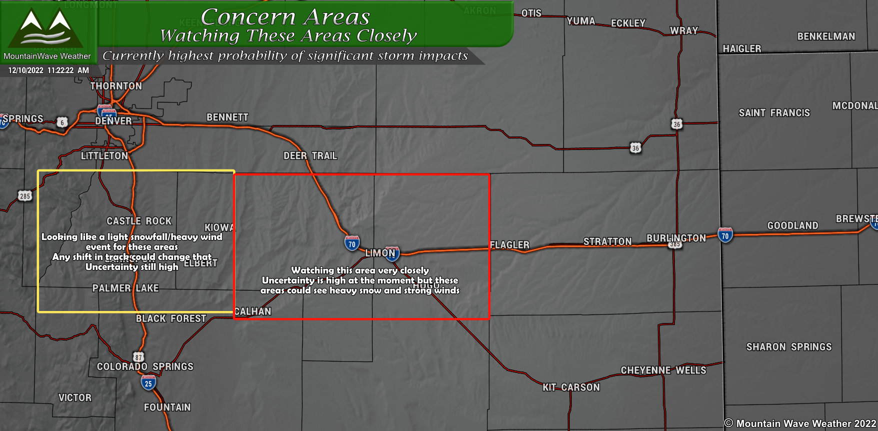
Palmer Divide
For the Palmer Divide, my highest area of concern is locations East of Douglas County. Elbert County from about Kiowa to Limon will have to pay close attention to the forecast over the next 48 hours as models do have this area right on the cusp of those higher snowfall/higher wind – blizzard condition impacts. Models are not showing a ton of snow, but enough that combined with the winds it could cause issues.
As you go further West, the probability of a high impact storm lessens, but we will still have to watch it.
Summary and What To Do
To sum up everything I’ve shown above…
- Very powerful storm
What We Know
- Northeastern Colorado, Nebraska, South Dakota, Parts of North Dakota, South Central and Southeastern Wyoming are all in the bullseye with this storm (currently)
- Heavy snowfall amounts between 1-2 feet are possible
- Strong winds are possible
- Blizzard conditions – dangerous travel conditions – road closures all possible in those areas
What We Don’t Know
- Exact storm track – models have agreement on the storm staying far enough North to not impact Central Colorado much – but we have to keep an eye on the track because any shift can drastically change our forecast
- Timing is not nailed down yet… but action time looks to be roughly Monday (late), Tuesday and Wednesday (early) for Eastern Colorado
- Exact snowfall amounts are not nailed down yet, any amounts you see posted online should not be taken as a forecast
Preparedness Action
Generally no action is needed at this point outside of staying up-to-date with the forecast.
If you live in Elbert, El Paso or Arapahoe counties and have ag interests, stay very aware of the forecast. You may want to being initial preparations to have food, shelter and water for livestock. I know these things take a bit of time, so consider this your heads up!
No guarantee this storm brings huge impacts to those areas… but it’s close enough that it has my attention – it should have yours as well!
I can’t reiterate this enough: ANY SHIFT IN THIS STORM TRACK WILL CAUSE HUGE CHANGES IN THE FORECAST
That’s why uncertainty is still high, as we get closer to the event we will see the models nail down the track a bit more and our confidence will increase. I know people want more fine details now, now, now – but we just aren’t there yet!
More updates to come, stay tuned!
