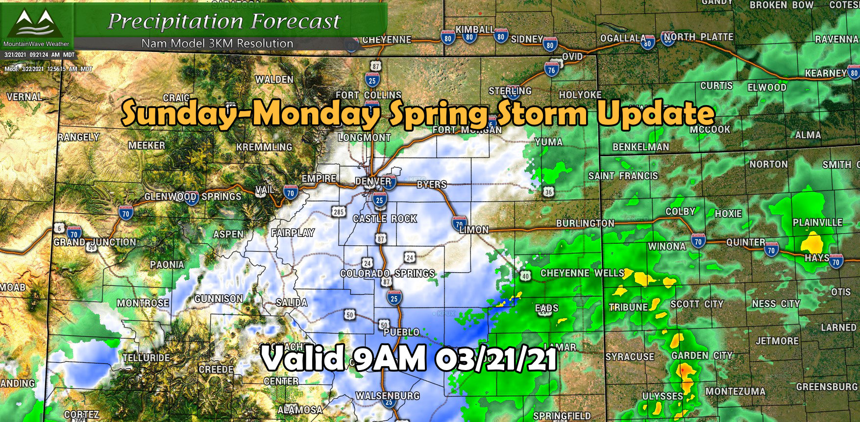
Lots to discuss this morning, we will update you on the latest weather alerts from the National Weather Service in Boulder, latest discussion on the storm track and intensity, snowfall forecast and wind impacts. Let’s dive right into it!
Winter Storm Highlights
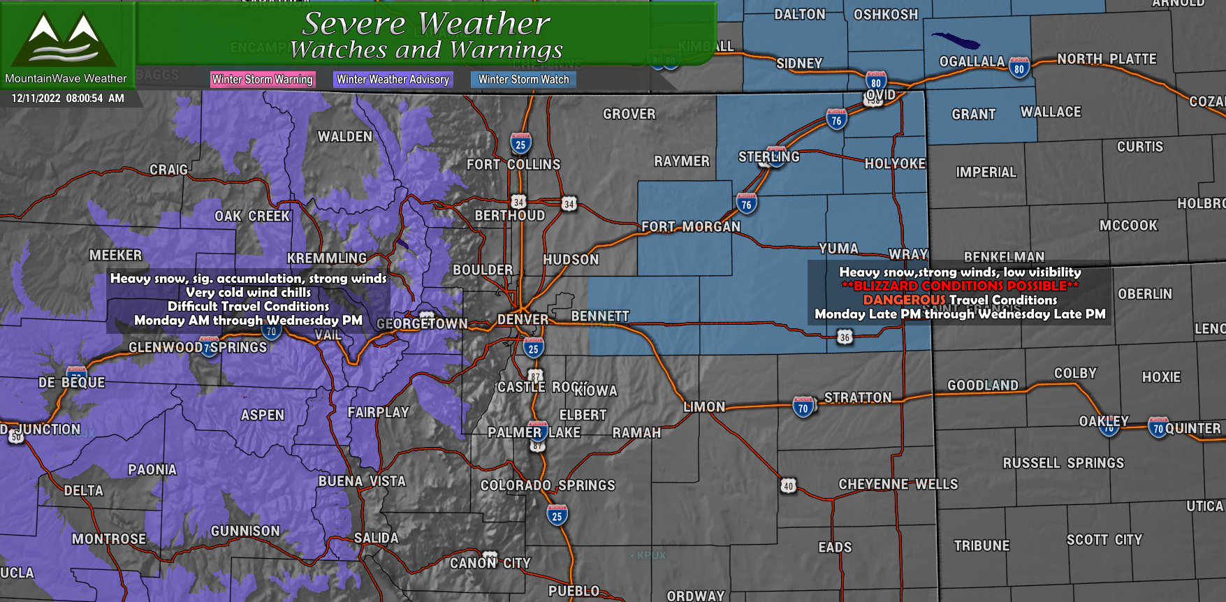
WINTER STORM WATCH IN EFFECT FROM LATE MONDAY NIGHT THROUGH TUESDAY EVENING…
* WHAT…Blizzard conditions possible. Total snow accumulations between 4 and 10 inches possible. Winds could gust as high as 60 mph.
* WHERE…A portion of northeast Colorado.
* WHEN…From late Monday night through Tuesday evening. Some light snow, blowing snow, and gusty winds may linger into Wednesday.
* IMPACTS…Visibility may be near zero at times due to snow and blowing snow, resulting in whiteout conditions. Travel may be treacherous and road closures will be possible.
Includes:
Morgan County-Central and East Adams and Arapahoe Counties-Logan
County-Washington County-Sedgwick County-Phillips County-
Including the cities of Leader, Peetz, Julesburg, Merino,
Holyoke, Sterling, Goodrich, Haxtun, Sedgwick, Otis, Ovid, Brush,
Akron, Cope, Wiggins, Last Chance, Bennett, Byers, Crook, Fort
Morgan, Deer Trail, and Amherst
Prepare for possible blizzard conditions. Continue to monitor the
latest forecasts for updates on this situation.
WINTER WEATHER ADVISORY IN EFFECT FROM PM MONDAY TO PM WEDNESDAY…
* WHAT…Snow and blowing snow expected. Total snow accumulations between 6 and 12 inches, with up to 18 inches in portions of the northern mountains including the Park, northern Gore, and Medicine Bow Ranges, and portions of Rocky Mountain National Park. Winds gusting as high as 50 mph.
* WHERE…Rabbit Ears Pass, Rocky Mountain National Park and the Medicine Bow Range, and The Mountains of Summit County, the Mosquito Range, and the Indian Peaks.
* WHEN…From 1 PM Monday to 5 PM MST Wednesday.
* IMPACTS…Roads will become slick and hazardous. Travel could be difficult. The hazardous conditions could impact the Monday evening, Tuesday, and Wednesday commutes.
Snowfall Forecast
Quick note on the snowfall forecasts, there’s still a lot of uncertainty with some of these areas. I’ve done the best I can with the data we have right now, but be advised that these amounts may shift and change throughout the day on Sunday. I will most likely have a new post up late Sunday night or early Monday morning with updated information.
Palmer Divide
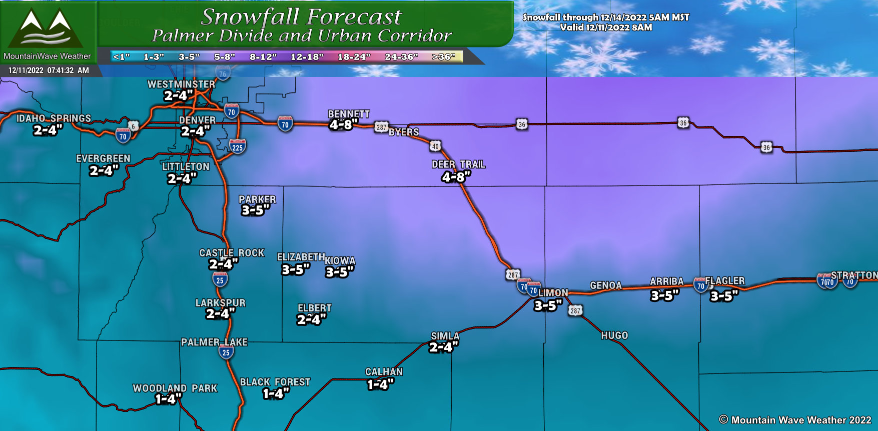
At this time, not looking like a major snow producer for much of the Palmer Divide, models however are still highly uncertain about snowfall further West along the I-25 corridor. I have a bit more discussion on this towards the bottom of this page, so be sure to read up on that if you live in those areas. Generally, more snow as you move Eastward, parts of Elbert County could see up to 4-6 inches in localized areas. The wind will be a factor as well so watch for drifting, I also discuss this with the wind section below.
Northern Colorado
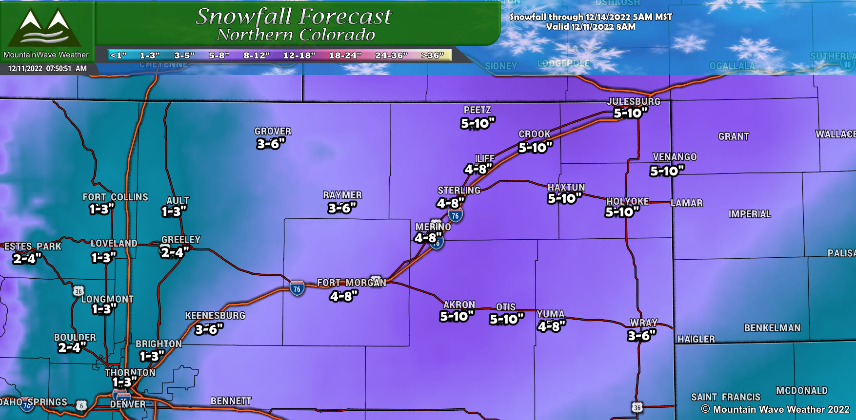
Northeastern Colorado still looks like the prime zone for the heaviest snowfall with this storm system. Areas on the plains could see up to 12″ of snow with strong winds. The Winter Storm Watch issued follows those areas pretty closely. If you live or have travel plans in those areas, I’d recommend being prepared for blizzard conditions and delaying travel if possible. Worst impacts look to come late Monday night and throughout most of the day Tuesday.
Northern/Central Mountains
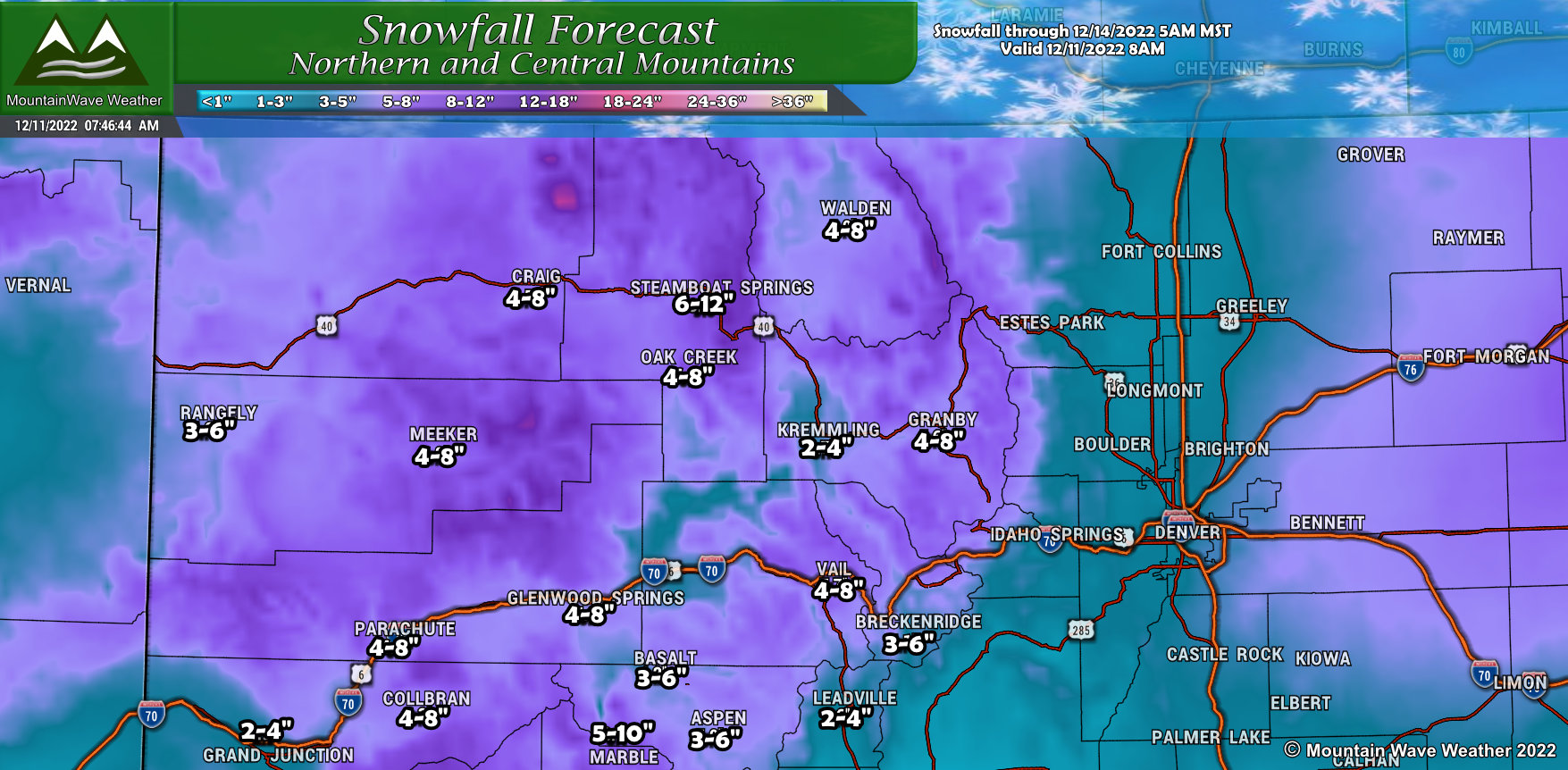 The Northern and Central Mountains will do quite well with this storm – adding to the snowpack is a good thing this time of year! Generally 6-12″ along the most favored slopes and peaks, valleys will see between 2-4″ or 3-6″. Some areas up in and around Steamboat may see storm total amounts push 18″ by the time this storm moves out. During the storm, travel in the mountains will be difficult, mainly on Monday and Tuesday so keep that in mind if you’re heading up that way.
Southwestern Colorado
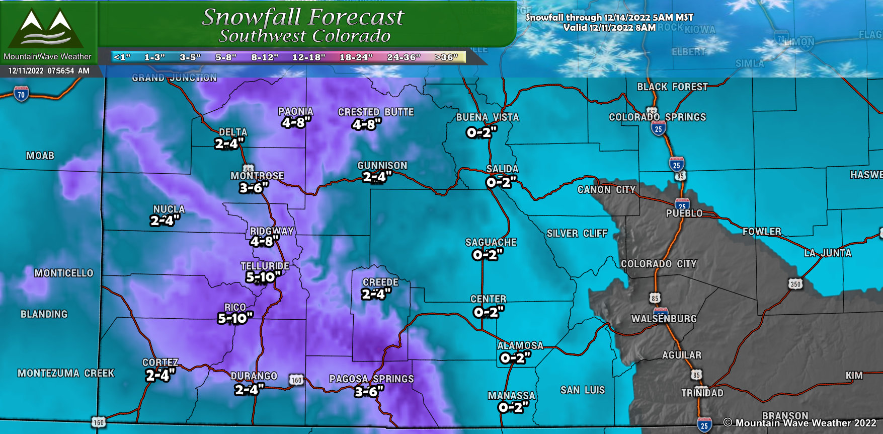
While this storm has a Northern track, enough moisture will pump in from the West as it crosses the mountains to dump a bit of snowfall on the Southern mountains. Generally 4-8″ or 5-10″ amounts are expected on favored peaks and mountain ranges, the valleys will see less snow but should still see a couple of inches.
Southern Colorado
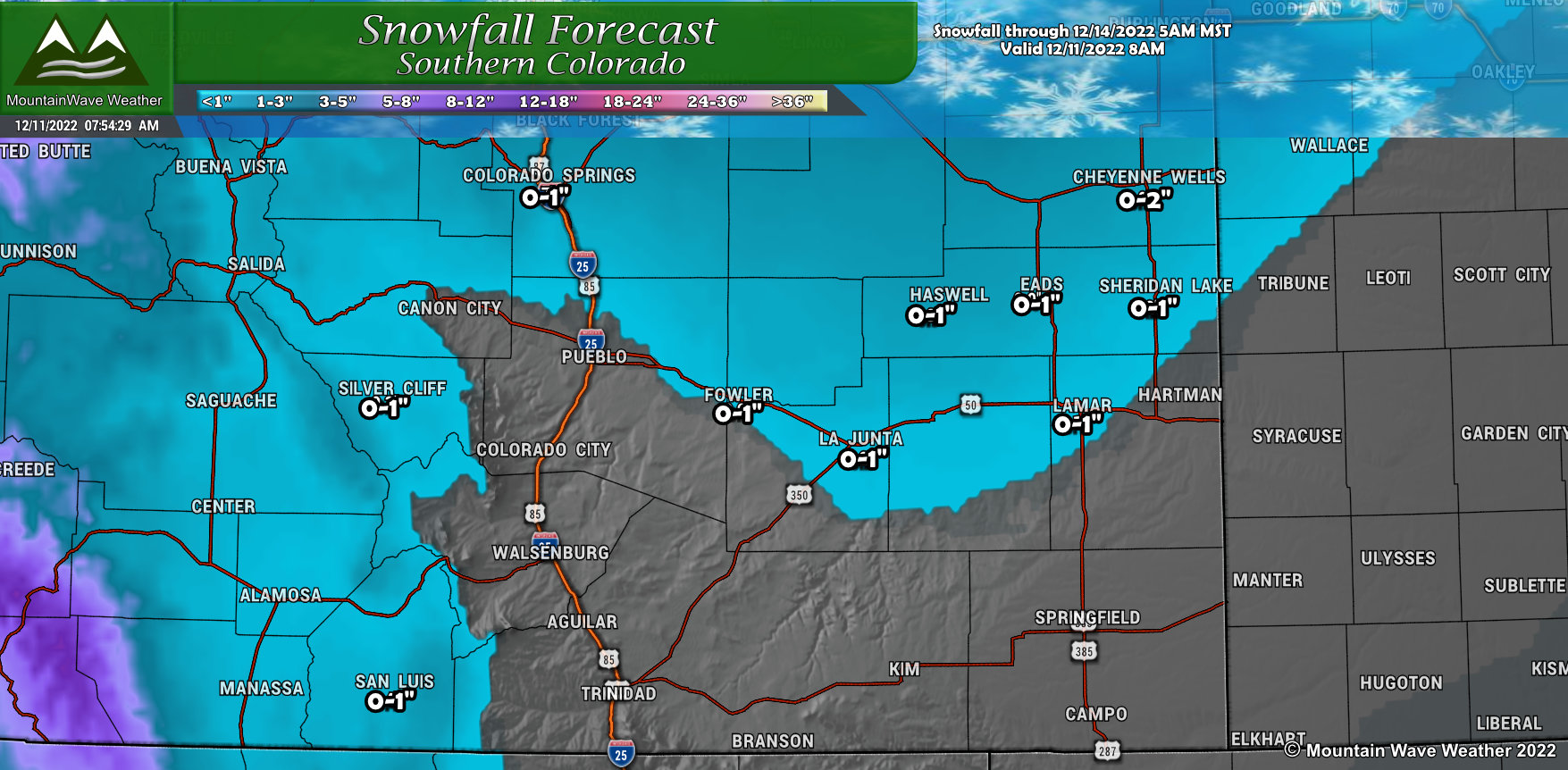
Southern Colorado will see more of a wind impact with this storm than a snow impact. Light snowfall amounts are expected across the Springs and points to the East and West. As you go further South towards New Mexico, little to no snow is expected. Keep a close eye on the I-25 corridor for wind related travel impacts Monday night and into Tuesday.
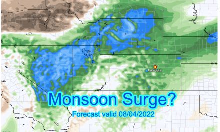
Wind Forecast
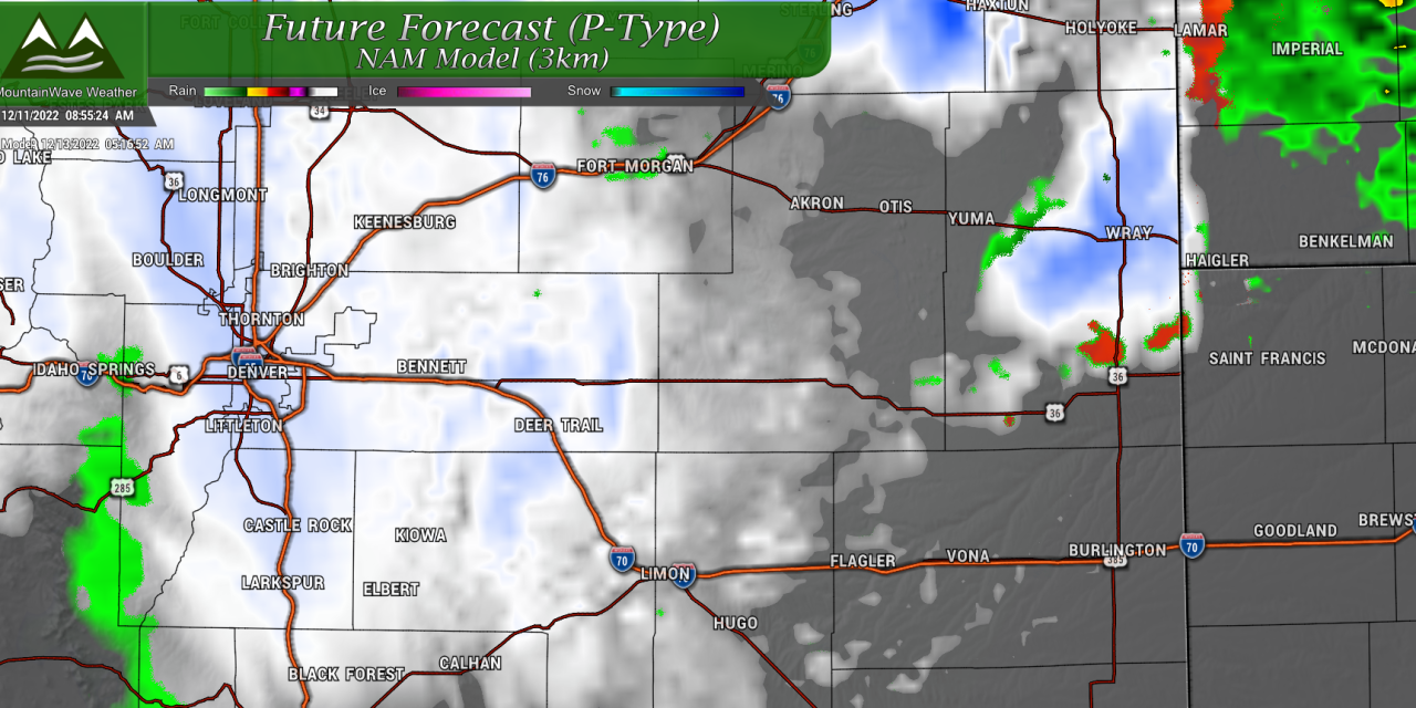
Wind is going to be the big issue with this storm, regardless of how much snow falls. You’ll see the areas with the highest wind gusts forecasted in the image below:
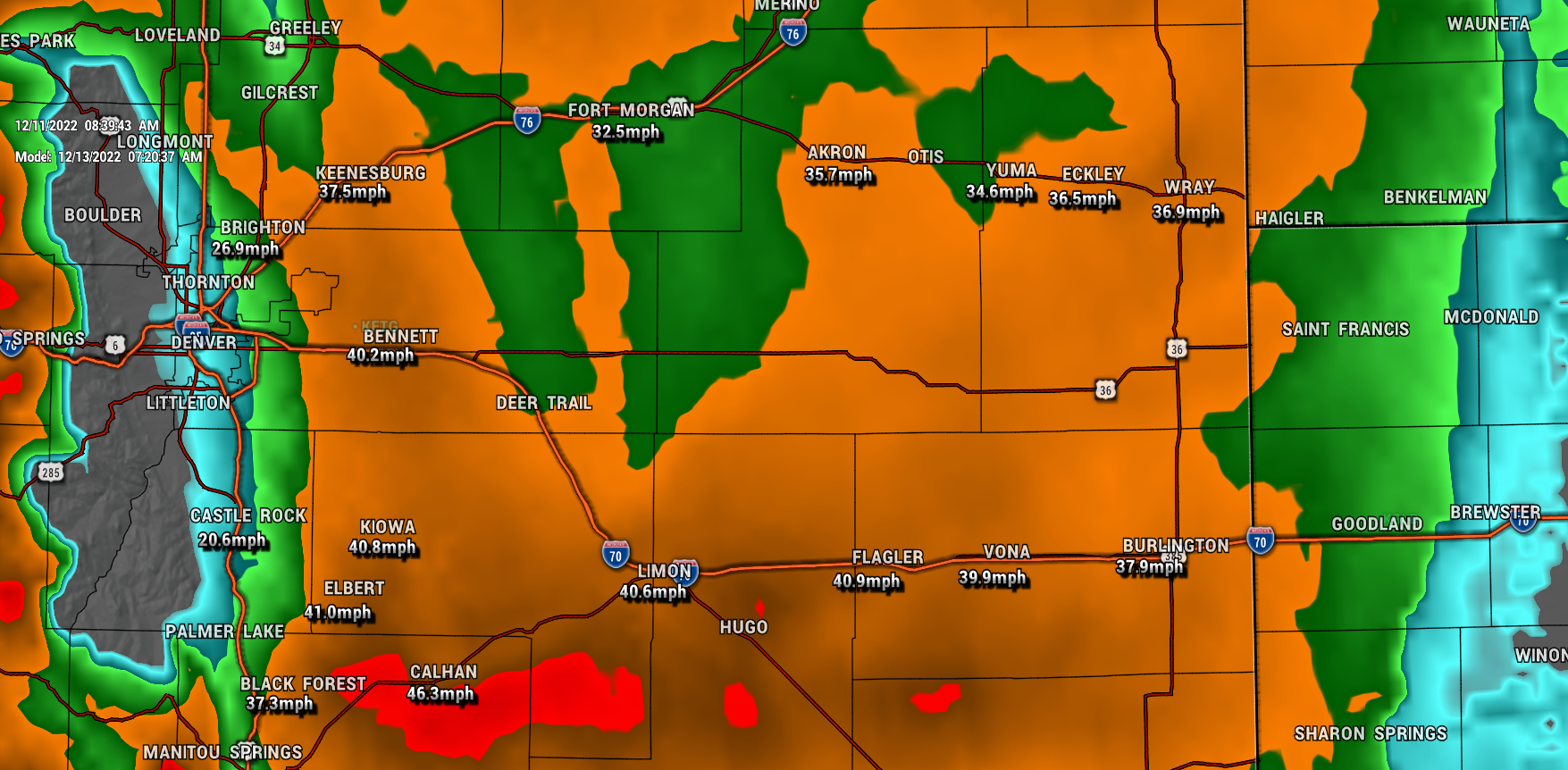 This snapshot is potential wind gusts on Tuesday morning, this would also be the time snow is falling for many areas, so reduced visibility, blowing snow and drifting are not out of the question – especially East of the I-25 corridor.
Even though locations such as Elbert and El Paso counties are not in any watches at the moment – I’m still stressing that folks in those areas be prepared.
Messaging/Preparedness
Here’s what we have so far:
Timing
- For the mountains, Monday morning through Wednesday morning has potential for heavy snow, wind and travel impacts
- For the Palmer Divide: Monday night into Tuesday afternoon will be the most likely time to see travel and snow/wind related impacts with this storm
- For the plains: Monday night, Tuesday and into Wednesday morning will see blizzard conditions, heavy snow and dangerous travel
Impacts
- Heavy snow, low visibility and dangerous travel for areas along the Northeastern Plains
- Moderate snow for areas along the Palmer Divide (mainly East, but watching for any creep back to the West), strong winds are likely
- Heavy snow and wind for the mountains
Preparedness
Time to start preparing!
- Northeastern Plains
- Plan on delaying travel. Travel not recommended from late Monday through Wednesday morning
- Ag interests? Have food, water, shelter ready and animals moved in if need be – these preparations should be completed by Monday afternoon
- Palmer Divide
- Still high uncertainty on snowfall in this region, but it is advised to be prepared just in case.. Heavier snowfall favored East of I-25 corridor if that materializes
- Ag interests? Have food, water, shelter ready and animals moved in if need be – these preparations should be completed by Monday afternoon
- Tie down any loose objects, things will blow away in 40-60mph wind gusts
- Mountains
- Plan on difficult travel. Highest travel impacts look to be Monday through Wednesday morning
- Heavy snow and strong winds will make for poor travel conditions especially over the higher elevations
One more quick note on the snow forecast:
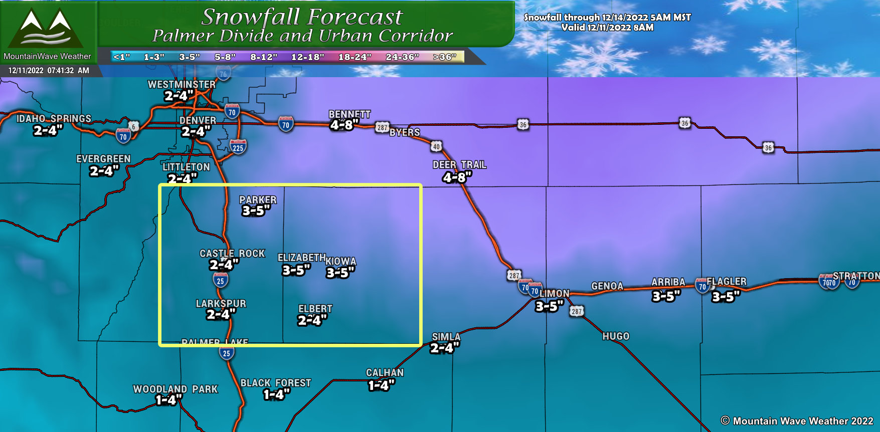
See that yellow box? Models have consistently been bouncing back and forth with snowfall in this area… I’ve gone fairly conservative with the snow amounts in this area, but it is possible this area over-performs. One trend we’ve seen over the last day is the heavier snow accumulation (pinks and purples) creeping further Southwest over the Palmer Divide.
We will have to watch this area closely – don’t sleep on snowfall for this region.
More information coming as needed! Stay tuned!
