Another storm system and cold front rolls through the mountains today and through the plains tonight. Mountain areas will see decent snowfall and cold temperatures during the day Monday, while the plains will see most of their impacts Tuesday morning. I've got the usual list of updates below including weather alerts, timing and impacts for the Palmer Divide/Denver area and as always, snowfall forecasts.
Winter Weather Highlights
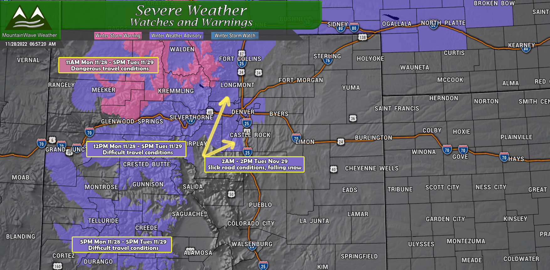
WINTER STORM WARNING REMAINS IN EFFECT FROM 11 AM THIS MORNING
TO 5 PM MST TUESDAY...
* WHAT...Heavy snow possible. Total snow accumulations of 8 to
16 inches with locally higher amounts possible. Winds could
gust as high as 45 mph creating areas of blowing snow.
* WHERE...Elkhead and Park Mountains.
* WHEN...From 11 AM Monday to 5 PM MST Tuesday.
* IMPACTS...Travel could be very difficult at times as blowing
snow significantly will reduce visibility. A detailed map of
the snowfall can be found at: www.weather.gov/gjt/winter.
WINTER WEATHER ADVISORY IN EFFECT FROM 2 AM TO 2 PM MST TUESDAY...
* WHAT...Snow expected. Total snow accumulations between 2 and 5
inches, with highest amounts closer to the foothills.
* WHERE...The Southern Front Range Foothills, Boulder and the
western suburbs of Denver, and Denver.
* WHEN...From 2 AM to 2 PM MST Tuesday.
* IMPACTS...Roads will likely become slick and hazardous. Plan on
slippery road conditions. The hazardous conditions could impact
the Tuesday morning commute.
WINTER WEATHER ADVISORY REMAINS IN EFFECT FROM 5 PM THIS
AFTERNOON TO 5 PM MST TUESDAY...
* WHAT...Snow expected. Total snow accumulations of 6 to 12
inches with locally higher amounts possible. Winds could gust
as high as 45 mph creating areas of blowing snow.
* WHERE...Gore and Elk Mountains/Central Mountain Valleys and
West Elk and Sawatch Mountains.
* WHEN...From 5 PM Monday to 5 PM MST Tuesday.
* IMPACTS...Icy to snow packed roadways will create hazardous
driving conditions. Blowing snow will also significantly reduce
visibility at times. A detailed map of the snowfall can be
found at: www.weather.gov/gjt/winter.
Timing and Impacts
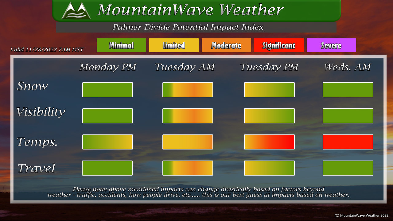
You'll see with this storm the primary impacts are related to the cold temperatures. Very cold temperatures will cause impacts late Monday, through the day Tuesday and into Wednesday morning. Those with livestock/ag interests along the Palmer Divide will want to make sure they have those animals taken care of with a warm spot to go to.
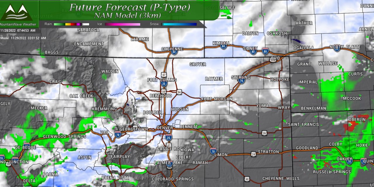
Snow and travel impacts come into play early Tuesday morning and through the early parts of the day on Tuesday. This is the timeframe we see snow bands rolling through and could cause the most travel headaches. We don't see a large amount of snow falling (wouldn't call those impacts significant or severe) but limited to moderate impacts are possible under snow bands which may provide quick shots of moderate to heavy snowfall. Moderate impacts means snow/slush accumulation on roads/ flash freezing of wet roads due to temperatures with ice forming could cause travel headaches.
Visibility will most likely only be impacted during times of snowfall so anticipate that during those times.
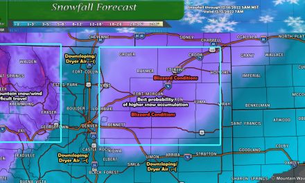
Snow Forecast
Palmer Divide
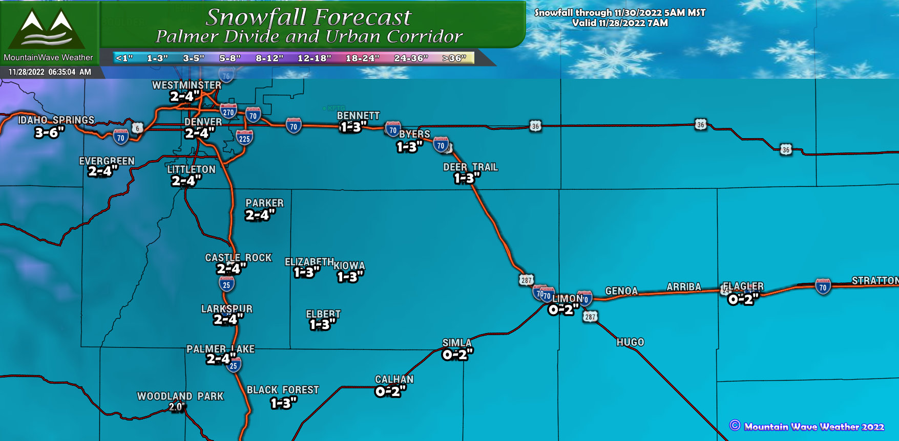
Generally light amounts forecast along the Palmer Divide, but we may see a bit more than the "dusting" type events we've had the past couple of storms. Snwofall amounts won't be what I'd call "large" but enough snow with cold and slick conditions for Tuesday morning. The rule of thumb will mainly be, the further North you go the more snow you'll likely see (higher end of the forecast amounts) while Southern sections will see the lower end of the forecast range.
Northern Colorado
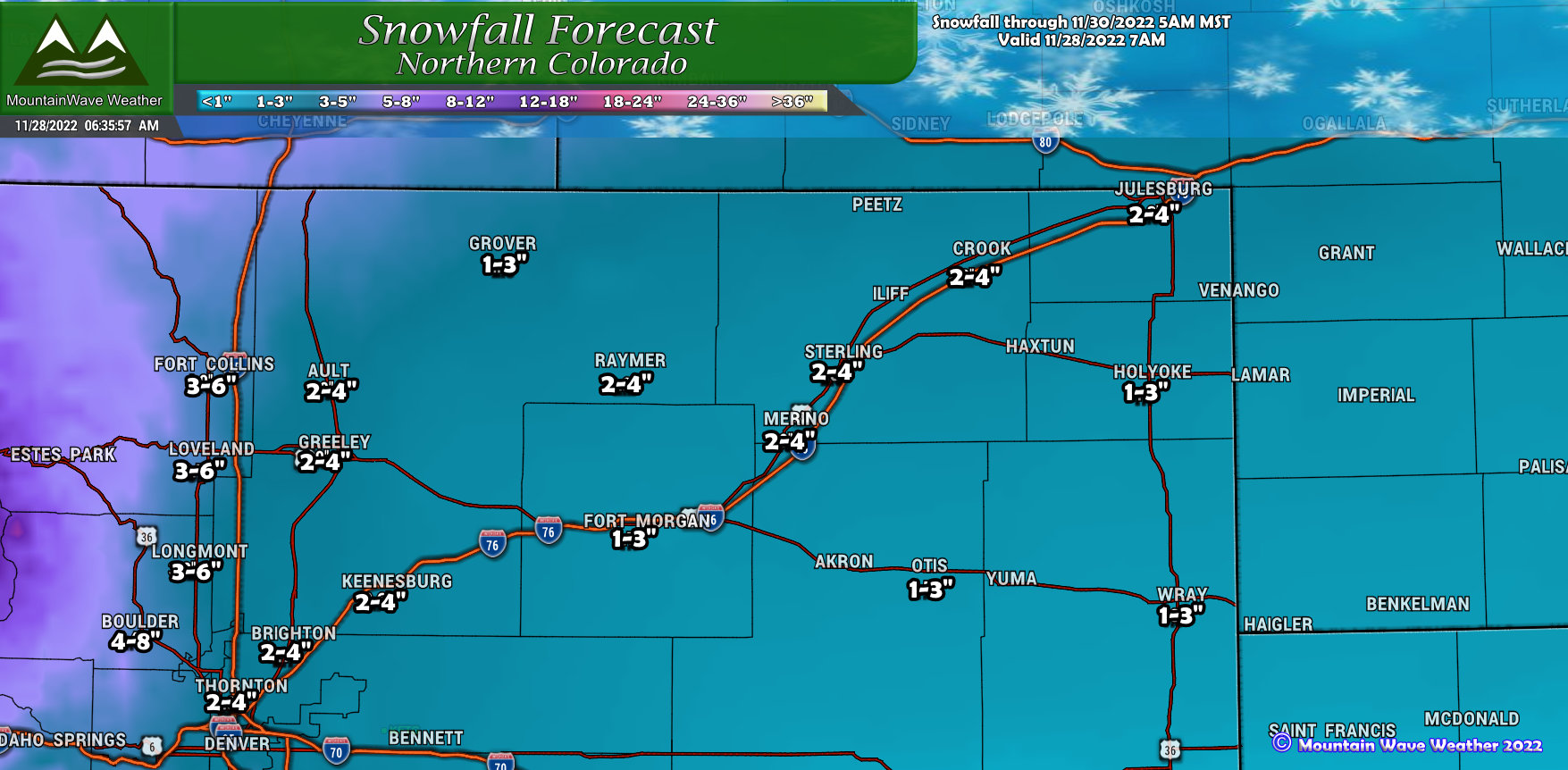
Northern Colorado will see a better chance at more accumulating snow due to the Northern track of this storm and many of those areas being under favorable lift from the jet stream. Areas West of Interstate 25 could see a few inches to several inches, more accumulation as you go further West into the foothills and mountains. The plains will generally be in the 2-4" or 1-3" range with higher ends of that forecast range as you go further West and the lower ends as you go further East.
Northern and Central Mountains/ I-70 Corridor
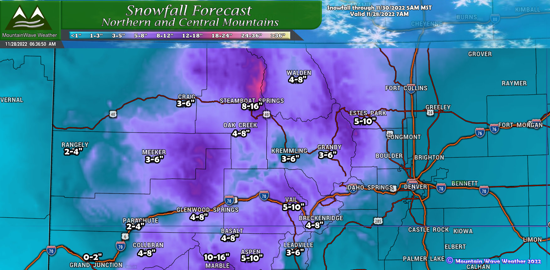
The mountains will benefit from this storm quite a bit after the past few storms haven't delivered much in the way of snow that could meaningfully build the snowpack. Many mountain resorts will see between 4-8" and 5-10" of snow through Tuesday night. This will create difficult travel conditions in the mountains (timing and impacts mentioned above) so keep that in mind if you have travel plans or want to take advantage of a powder day on Tuesday and potentially Wednesday.
Southern Colorado
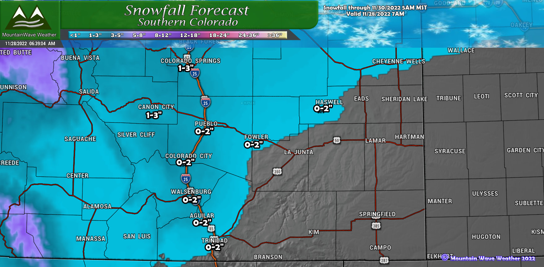
The Northern track of this storm will leave many parts of Southern Colorado high and dry or with generally light snowfall amounts. Best shot at any snow is along the I-25 corridor and Westward into the mountains and foothills... even then amounts won't be anything to write home about.
Southwestern Colorado Mountains
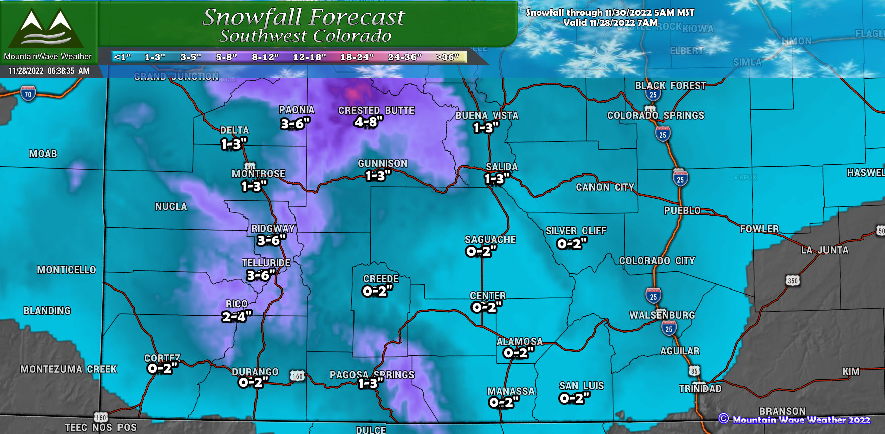
Southwestern Colorado will see a bit of snow out of this storm as well, mainly for favored slopes and peaks and up towards the North around Crested Butte. Other valleys and lower elevations won't see a whole lot, but have chances of seeing an inch or two. Some roads over the higher passes could be slick due to that snow and ice accumulation.
Be Prepared for Very Cold Temperatures!
Arctic air will filter in behind a front that moves through late Monday and early Tuesday morning. Behind this front temperatures are very cold in the teens and single digits. While cloudcover and snow may dampen this cold initially on Tuesday, by later in the day we could see temperatures drop further as the storm moves out and skies clear.
The quicker the storm moves out on Tuesday the colder Tuesday night/ Wednesday morning could be... so take the temperatures on the model snapshots below with a grain of salt. It's possible that they are too warm by up to 3-5 degrees for many areas.
We'll take you through the progression of the cold air below:
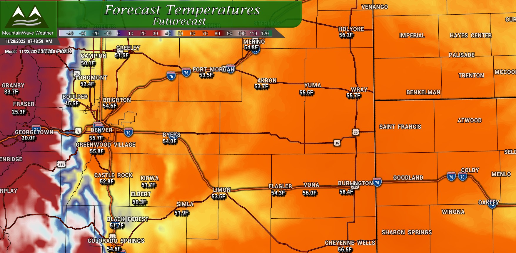
Monday afternoon temperatures (close to daily highs.)
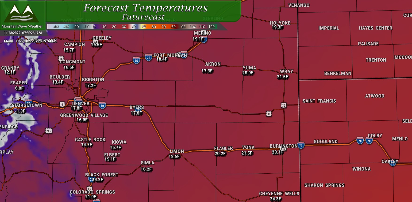
Tuesday morning temperatures (likely not daily lows, those may come in the afternoon/evening hours)

Wednesday morning temperatures (likely daily lows as we see warming later on Wednesday)
Again, we'll be watching timing on when that storm moves out - we may need to adjust these numbers downwards... keep an eye our for details on that.
Summary
This storm is still evolving for areas South of Denver. As such one more large forecast update or change may be needed - that will most likely be posted late tonight before the storm's arrival. I'll have any small changes to trends I'm noticing up during the day on social media but expect that larger update late tonight, most likely after 10PM. Forecast confidence is medium/high for Denver and areas North, it's high for the mountains - only medium for the Palmer Divide and Colorado Springs/Pikes Peak region. I'll need more data to nail that down.
Stay tuned!
