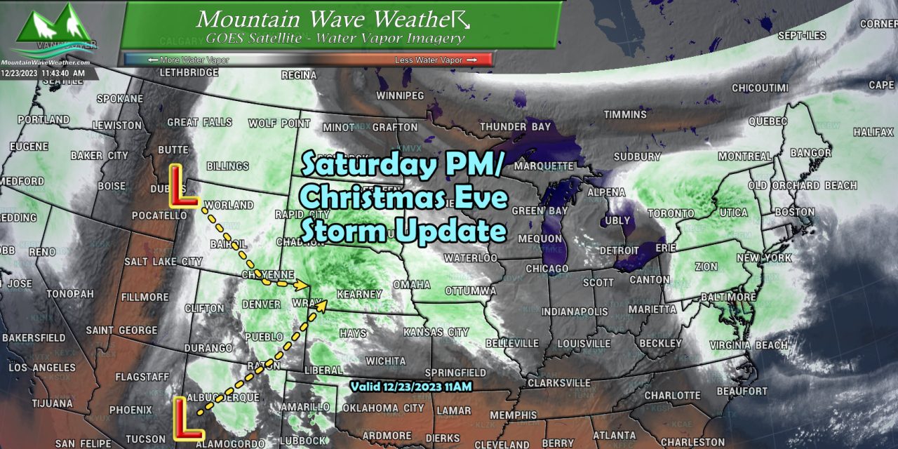
Our complex storm system continues to slowly creep its way towards the state. The main low pressure system is currently swirling into Western New Mexico and beginning its turn to the Northeast. Meanwhile the northern storm system responsible for our cold air is leaving Montana and moving Southeast into Wyoming.
Still lots of questions about how these two storms interact once they get close to Colorado. While things are still fuzzy from a forecast standpoint, we have enough details to help you prepare for the best case and worst case scenario.
Here’s the update.
Winter Weather Highlights
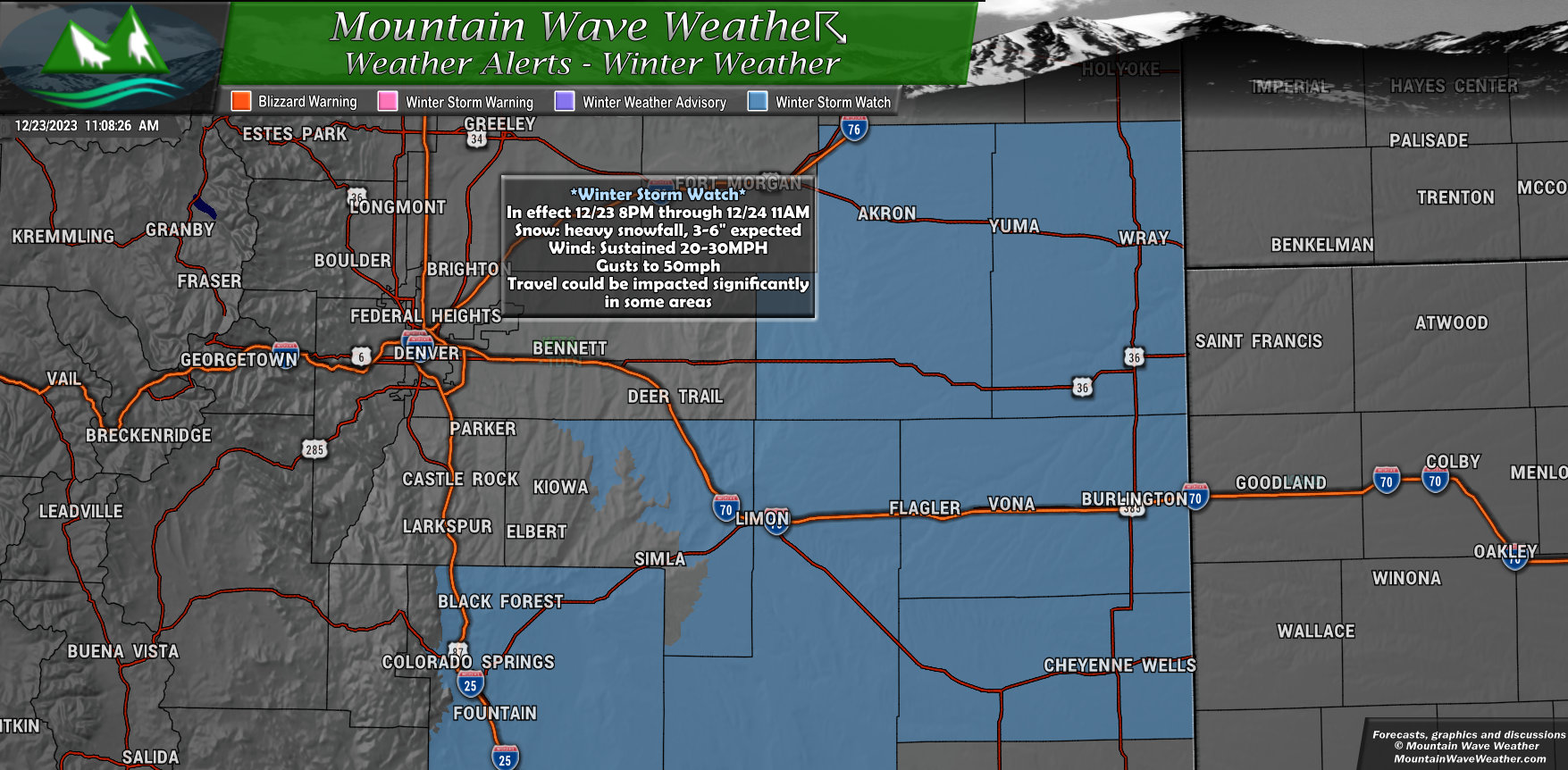
Winter Storm Watch
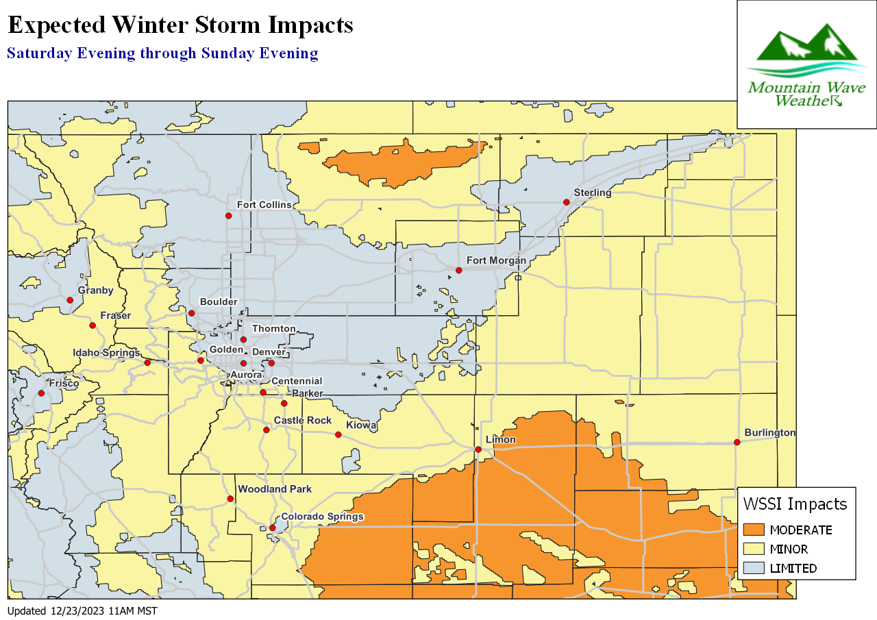
The watch areas are for the Eastern plains and areas South of the Palmer Divide going into Black Forest and Colorado Springs. This watch runs through 8PM tonight through 11AM tomorrow morning.
The main story will be the heavy snowfall possible and the strong winds. Do not rule out a couple of these areas meeting criteria for Blizzard Warnings… so keep that in mind if you have travel planned through these regions tonight.
Wind gusts up to 50mph and at times heavy snowfall could make travel dangerous through this stretch. I’ll have additional details later today.
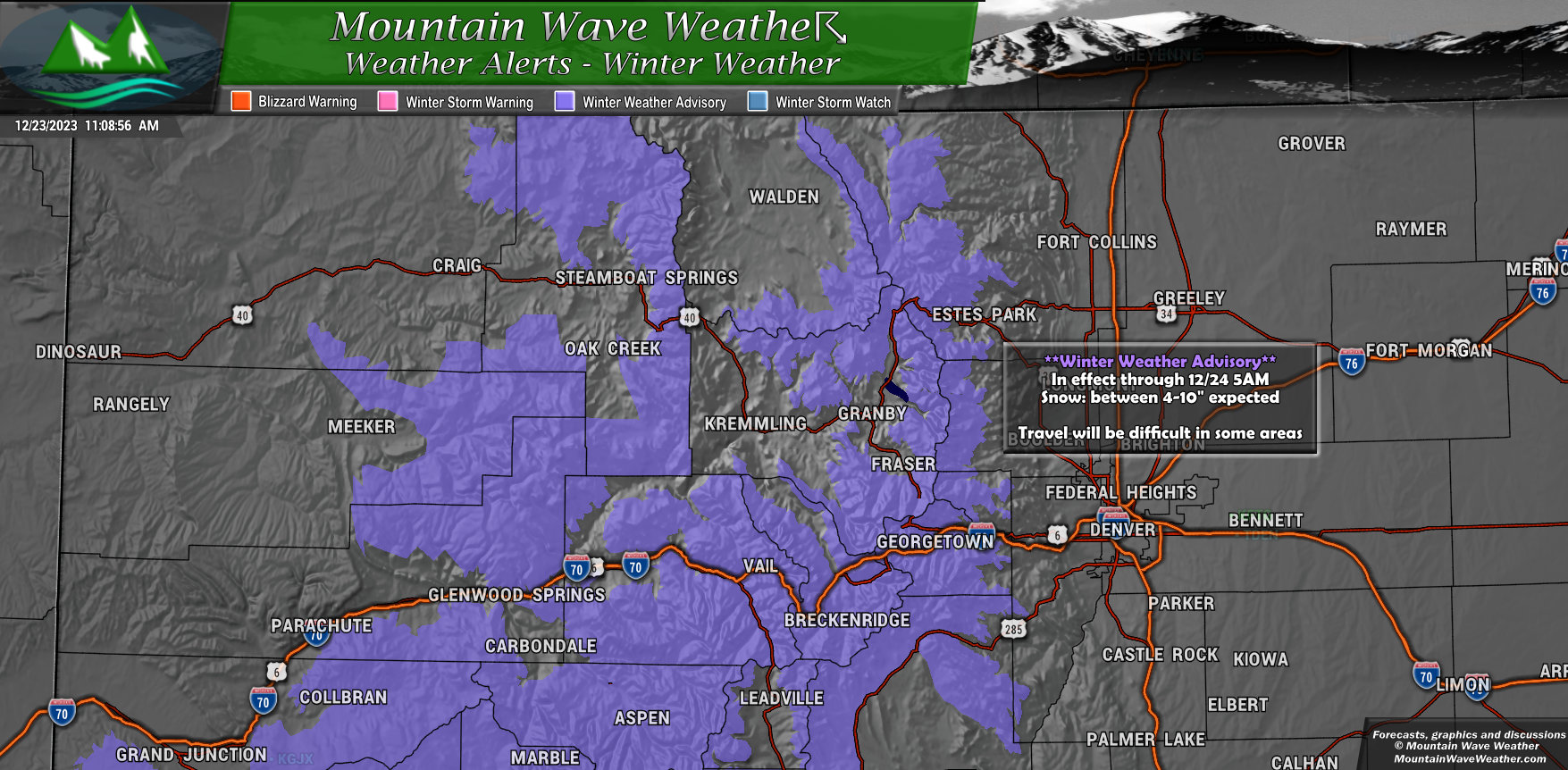
Winter Weather Advisory
For those traveling into the mountains, you will also see difficult travel conditions do to snow and icy/snowpacked roads.
The Winter Weather Advisory is in effect as of this post and runs through 5AM tomorrow morning.
Keep this in mind if you’re heading to the mountains, it will be slow going!
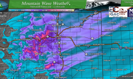
Snowfall Forecast
Only minor adjustments made to the snowfall forecast, I lowered snowfall accumulation slightly for a few areas – especially to the East of I-25. Castle Rock really is flirting more with that 2-4″ range but left at 3-6″ because I don’t think that it’s out of the question that some of the Western parts of town see that 6″ total realized.
Palmer Divide/Denver
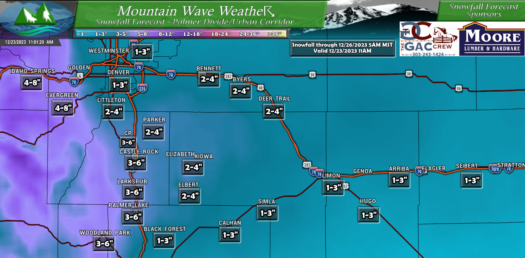
Other than the adjustments discussed above – other areas pretty much stayed the same.
Despite how close we are to the storm’s arrival, confidence in snowfall amount numbers overall remains low because we simply do not know how these two storms will phase together. The when, where and how strong are all factors that we don’t have a good handle on and those factors will make a huge difference in what we see vs. what we don’t.
More Details on Timing and Impacts
A lot of this precipitation may start out as rain Saturday evening. The cold front is expected to move through sometime between 6-8PM which would prompt a quick changeover to snow (espeically for higher elevations)
After that point is when we could see bands of heavy snow form, which would cause minor to moderate impacts overall
The highest chance of more moderate type travel impacts is the Eastern plains and the areas generally East of Colorado Springs. Those areas will see a combination of wind and snow that could make travel quite nasty. I wouldn’t rule out seeing some of these conditions in Central and Eastern Elbert County as well.
Here’s the updated Winter Storm Severity Index for the region.
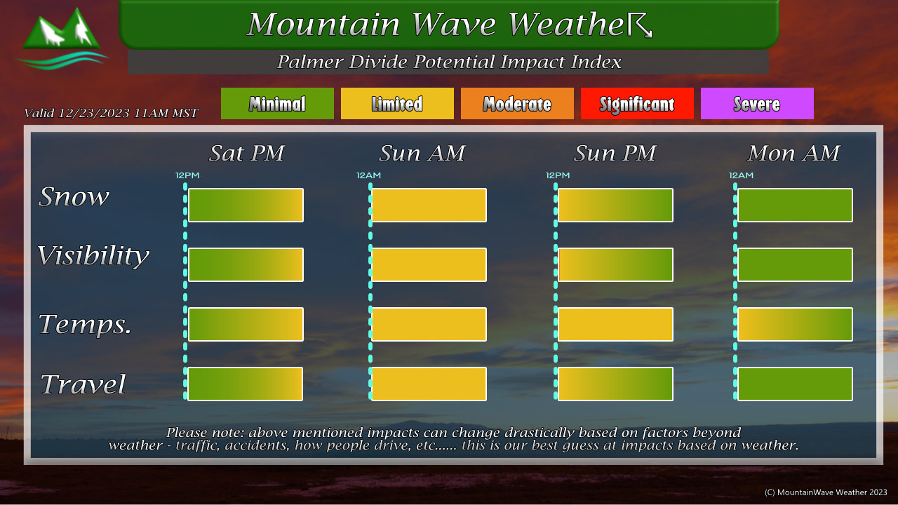
As far as more specific impacts for the Palmer Divide area, I’ve posted this graphic below. Here’s a quick summary:
- Snow starts in the later evening hours
- Heavier snow overnight
- Temperatures will be overall cold but not extreme for this time of year
- Visibility may suffer during bouts of heavier snow and some bits of wind
- General clearing by Sunday afternoon, some lingering showers may last through Monday morning – but the main energy leaves on Sunday
At this time, it does not appear this storm system will have MAJOR snow accumulations or cause MAJOR impacts along the Palmer Divide. This is more of what I like to call a “headache” storm as the potential for travel impacts and difficulties will be present. We just won’t see major issues for the most part.
That wraps up the forecast update for now. I will have another this evening if something drastically changes, otherwise I’ll just have a quick post that everything looks on track and we’ll see what this storm ends up doing!

