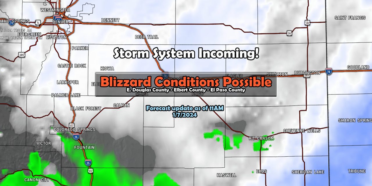
Lots of similarities with this storm and our last, Blizzard conditions with strong winds and falling snow are possible – but the impacts look greatest East and Southeast of the I-25 corridor.
Suffice to say, the closer you are to I-25 and Westward, you may see the snow but the wind will be less of a factor – meaning impacts will likely be less for those living along I-25.
However, if you live out East towards Elbert County and into El Paso county, winds will be very strong and there will be enough snow to cause some serious problems.
Here’s the latest as of this morning…
Weather Highlights
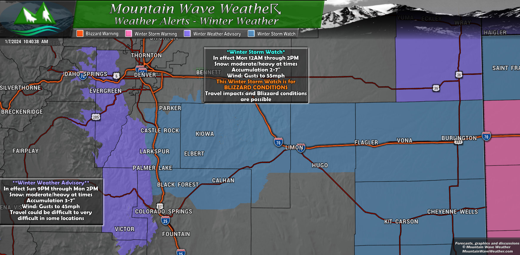
For the Palmer Divide, a *Winter Storm Watch* will go into effect tonight at midnight and run through 2PM on Monday.
This watch is for potential BLIZZARD CONDITIONS. Should this be upgraded to a warning – travel will be strongly discouraged… especially in areas East of Castle Rock like Elbert County.
Not expecting a ton of snow out of this storm, but the combination of moderate/heavy falling snow and strong winds will create periods of near zero visibility making for very dangerous travel conditions. Continue to monitor the forecast for this. If you have any plans late tonight and especially into tomorrow morning, I’d recommend you try to postpone until this storm has passed.
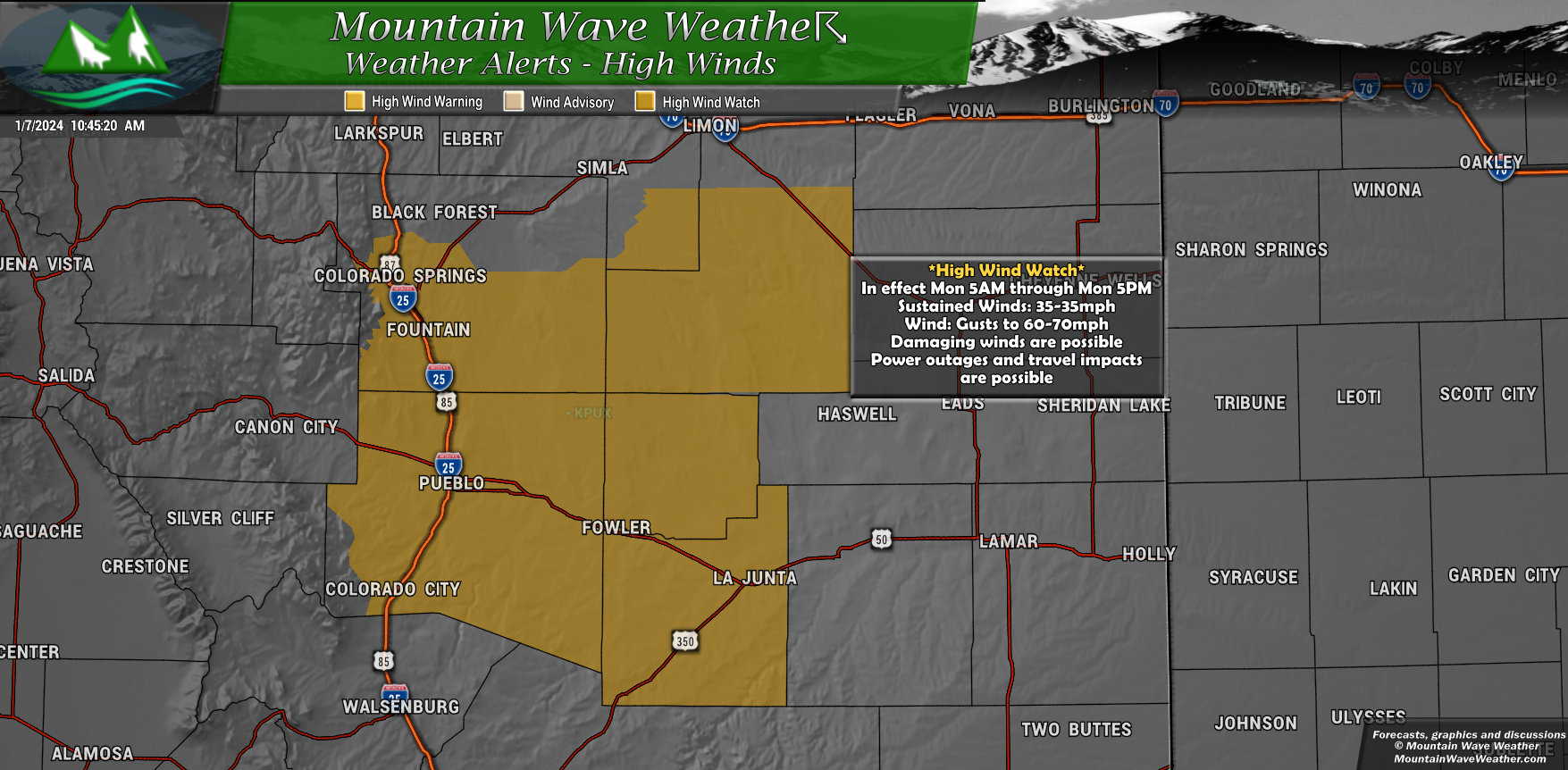
Further South, snow may be less of a problem but the strong winds won’t be. A *High Wind Watch* will be in effect Monday 5AM through Monday 2PM for wind gusts up to 60-70mph. Winds like this can cause property damage, blowing dust, power outages and make travel dangerous for lightweight and high profile vehicles.
Wind direction will predominantly be out of the North so expect those East/West roads to be particularly tricky.
Snowfall Forecast
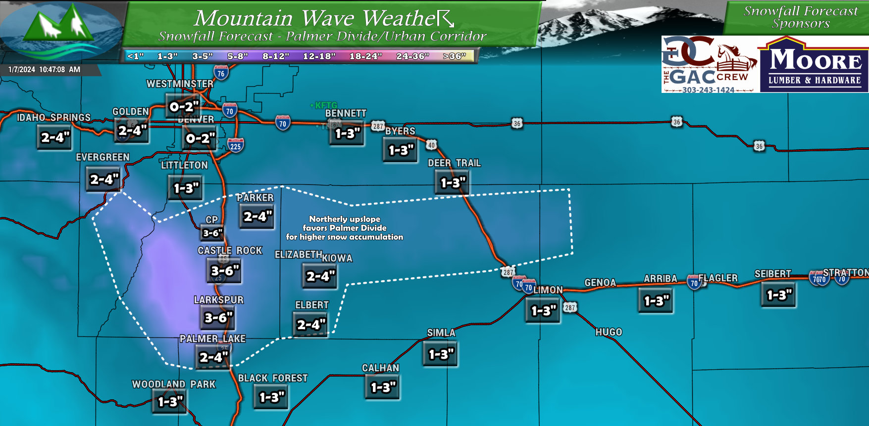
Palmer Divide
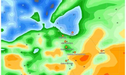
My snowfall forecast for the Palmer Divide is shown below. I’d like to point out, these snowfall accumulation amounts aren’t what I’d consider “major” but there will be enough snow and strong winds so that travel will be impacted – again the main focus here for the worst of it is East of the I-25 corridor.
Northerly upslope from storms like this tends to favor our area so we will see more snow than Denver and more snow than Colorado Springs, which will be in a downsloping position. This means the air dries out further South of the Palmer Divide… the same effect happens to Denver from the Cheyenne Ridge to the North.
Colorado/Kansas Snowfall
Here’s a quick snapshot of some of the other areas you’ll need to watch out for. As this storm strengthens and moves East, places like Kansas and Nebraska will get hammered with heavy snow, blizzard conditions and high snowfall accumulations. Keep this mind if you have plans to travel in these areas on Monday / Tuesday – things could be very difficult if-not downright dangerous out there.
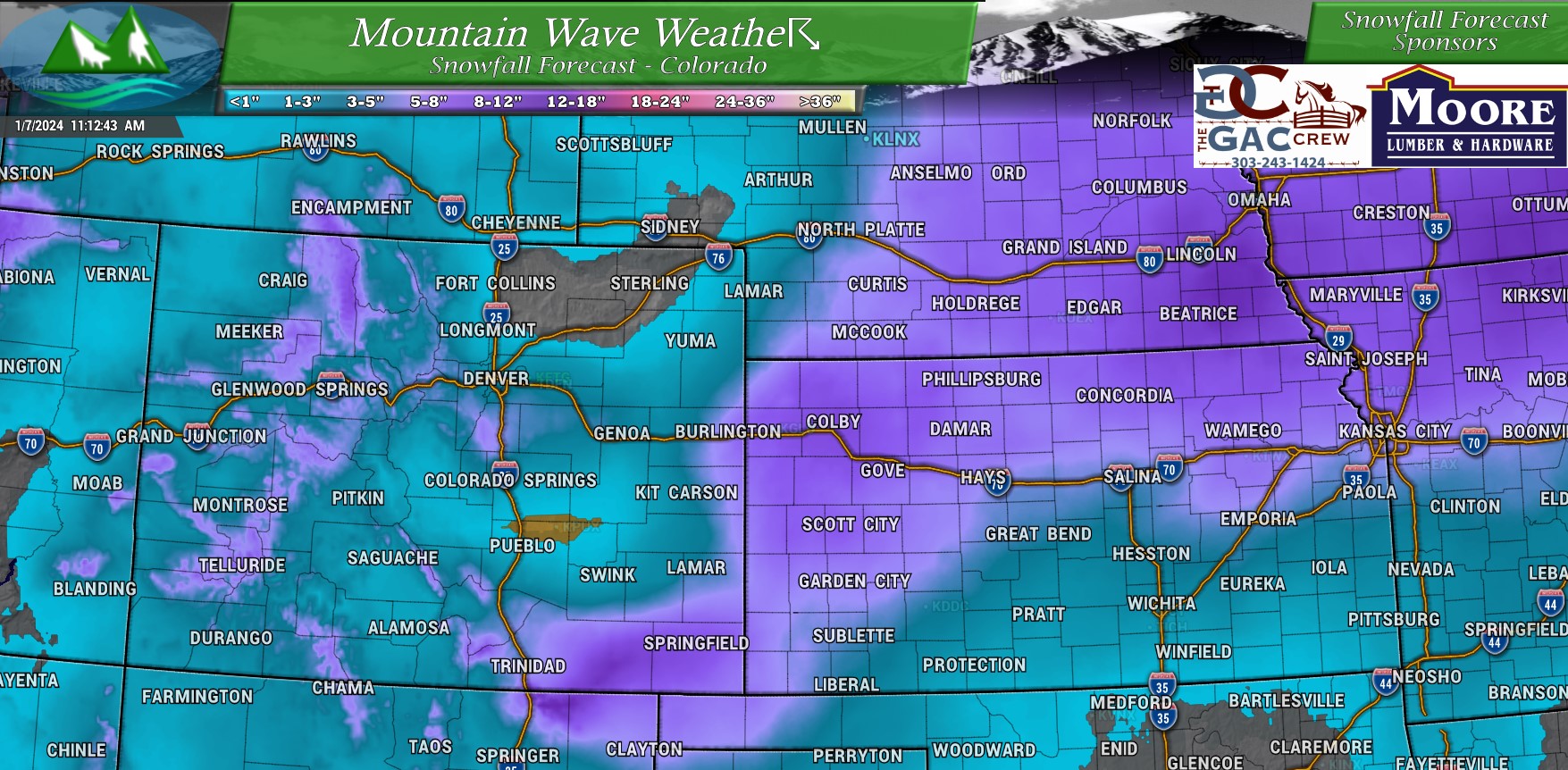
Highest snowfall amounts in Colorado look to be across Southeastern Colorado, parts of the Southern mountains and up near areas like Steamboat.
Timing and Impacts
Timing for the worst out of this storm looks to be early Monday morning and into early Monday afternoon
The Monday morning commute will likely be impacted.
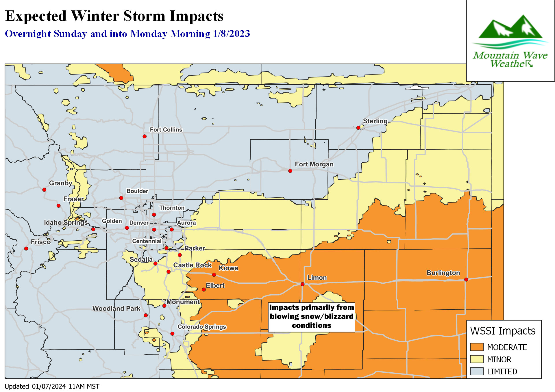
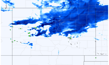
Here’s the Winter Storm Severity Index graphic that will give you a good idea of where you’re likely to see the most travel impacts.
Notice the moderate areas are mainly East of the I-25 corridor… so as I mentioned – areas like Castle Rock may not see more than minor impacts to travel… more of the rural areas out East and into Elbert County will see moderate or higher travel impacts.
This graphic is not posted because of impacts due to snow accumulation, it’s posted because of a combination of falling snow and strong winds. Snow amounts actually won’t be terribly high.
The wind really will be the major story for a lot of us with this storm – especially out East and Southeast.
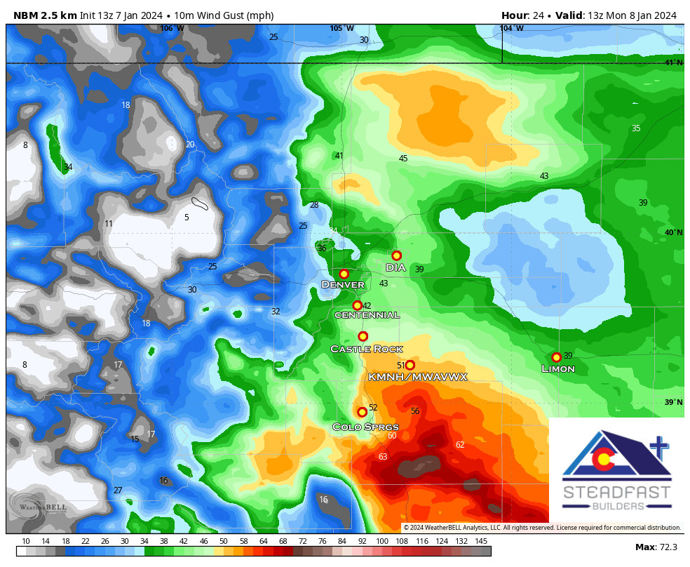 For example, in the NBM product shown above for Monday morning around 6AM – wind gusts over 50mph are possible at my location with some gusts over 60mph not too far to my South and Southeast. Castle Rock however, may only see gusts in the 30mph range at this time.
So you can see why I’m highlighting a lot of those areas East and Southeast of Castle Rock/ The Springs as the areas most to look out for travel and storm impacts.
Stay tuned for more updates throughout the day on Sunday!
