There’s a lot going on in the weather world despite our hot, dry and mainly quiet stretch. We’ve been keeping an eye on some of the longer range data coming out, how ENSO (el nino/ la nina) is setting up and general weather patterns. Today I’ll start with a preview of this week’s weather which will most likely a preview and a good segway into what summer could be like for us.
This Week
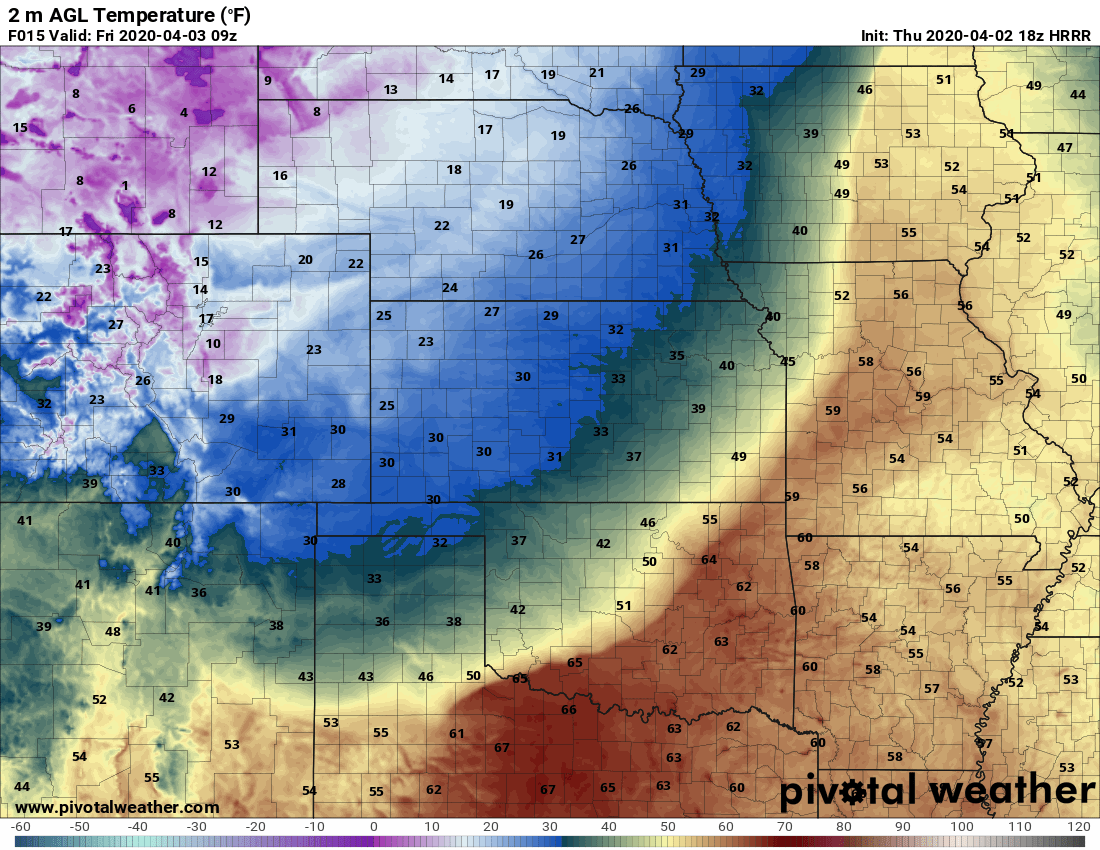
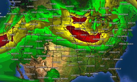
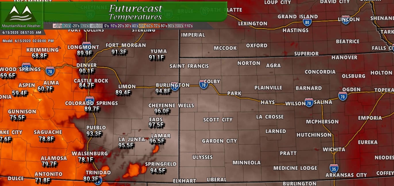 The Nam3K snapshot above shows forecast high temperatures for the day on Monday, notice the amount of heat strecthing across the plains and back into Colorado. This will be the theme for most of the week with hot and dry conditions. The sad part is there will be quite a bit of wind again with this setup (not as much as we saw with last week’s wind events though) and any thunderstorms that do form will mainly be wind and lightning. This will definitely ramp up our drought and fire concerns.

Weekly forecast provided to site supporters – this week will be mainly hot, dry and windy!
If you follow along as a site supporter (thank you so much by the way if you are!) you’ll recognize the graphic above as our weekly outlook. As you can see, temperatures right at around 90 or so which is quite hot for Castle Rock for this time of year. We do see a slight cooldown with a front moving through on Thursday but it remains to be seen if we get any decent moisture out of it (not looking promising right now.)
We will keep an eye for any changes but this looks pretty set for this week… in fact some of those high temperatures forecast may turn out to be too low!
Let’s Talk About Summer…
Expanding Drought May Be a Preview of What’s to Come
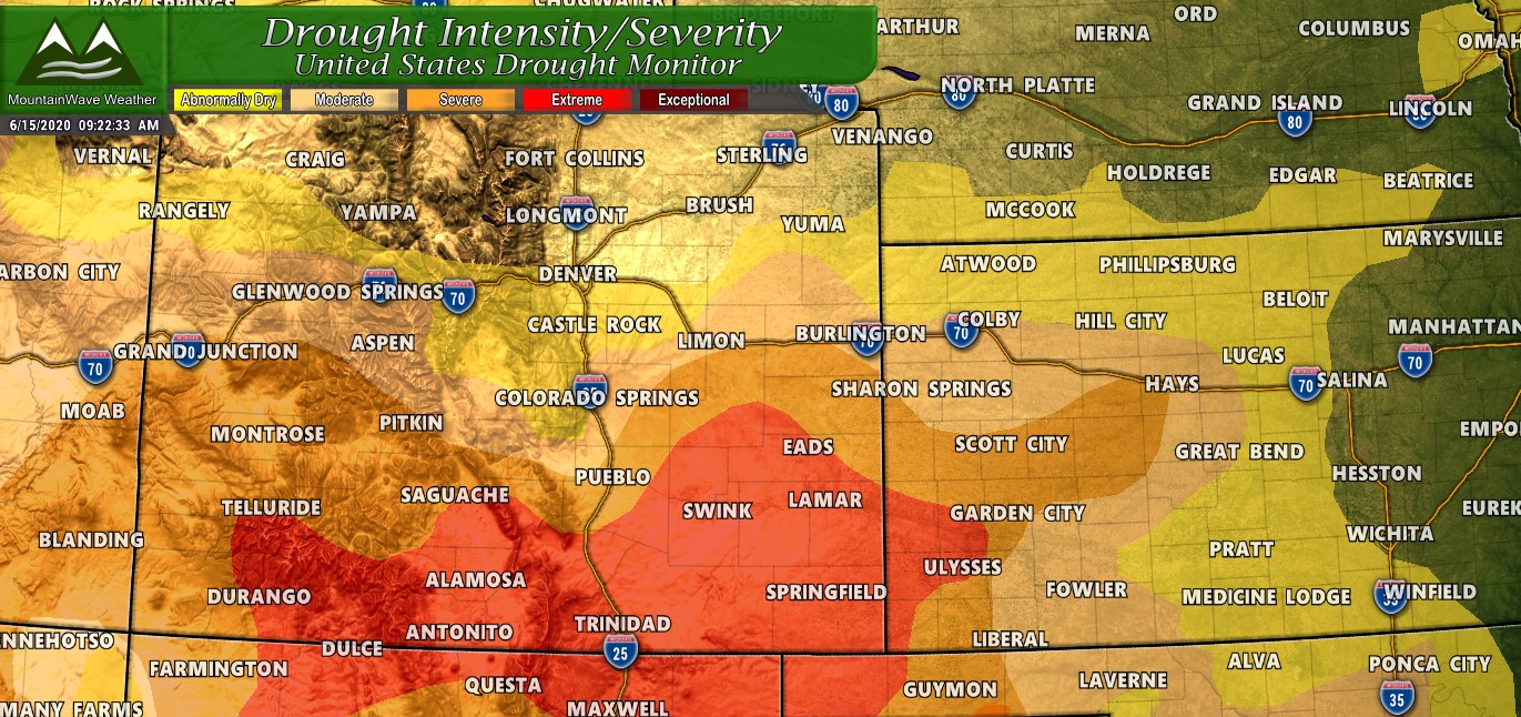
Updated drought areas/severity as of 06/11/2020
Drought is expanding across Colorado with many areas in Southern Colorado now in “Extreme” drought. While Denver hasn’t quite made it into drought territory, many areas Southwards towards the Palmer Divide are in an “abnormally dry” or “moderate drought” state as we’ve been below average or at average on precipitation for the past several months. Remember, it takes several months of above average precipitation to break a drought and we simply haven’t seen that at all so far this year.
The folks that run the United States Drought Monitor said in this last update:
Extreme drought (D3) was expanded across southeast Colorado based in part on soil moisture in the lowest 5th percentile. Above normal temperatures coupled with periods of strong winds continue to result in rapidly worsening conditions and reports of widespread selling of cattle. Trinidad, Colorado recorded only 1.66″ of precip year-to-date which is the driest January 1-June 9 on record. Data here dates back to 1948.The intensifying and developing drought conditions across Oklahoma also extended into the southern two-thirds of Kansas. This region missed out the widespread rainfall farther to the north across Nebraska and much above normal temperatures prevailed during the first week of June.
We expect this trend to continue (as I’ll explain in just a bit) but keep an eye on areas in and around Denver – they will most likely be added to drought conditions pretty soon. The CPC says drought conditions are likely to continue and expand in Colorado to the North.

Many areas across the West (including Colorado) will likely see continuation of or expansion of drought conditions
Is There Anything to This Gloom and Doom?
We don’t do “Doom and Gloom” at MountainWave Weather – but we do believe in giving people the right information so they can be prepared for what’s to come. Drought is a serious part of life in Colorado, we often experience years at a time where we receive plenty of rain and snow, our reservoirs are full and water is not much of an issue.
This has been the past few years for us…
Alternatively we can experience years of intense dry conditions or average and below average precipitation culminates in drought. Especially when we see hot years with a lot of wind like this year has become. Hot temperatures and lots of wind can give us clues about what our weather pattern is doing and what it may lean towards in the future. I think the wet years we’ve had the past few are ending and we are transitioning into a longer term dry period.
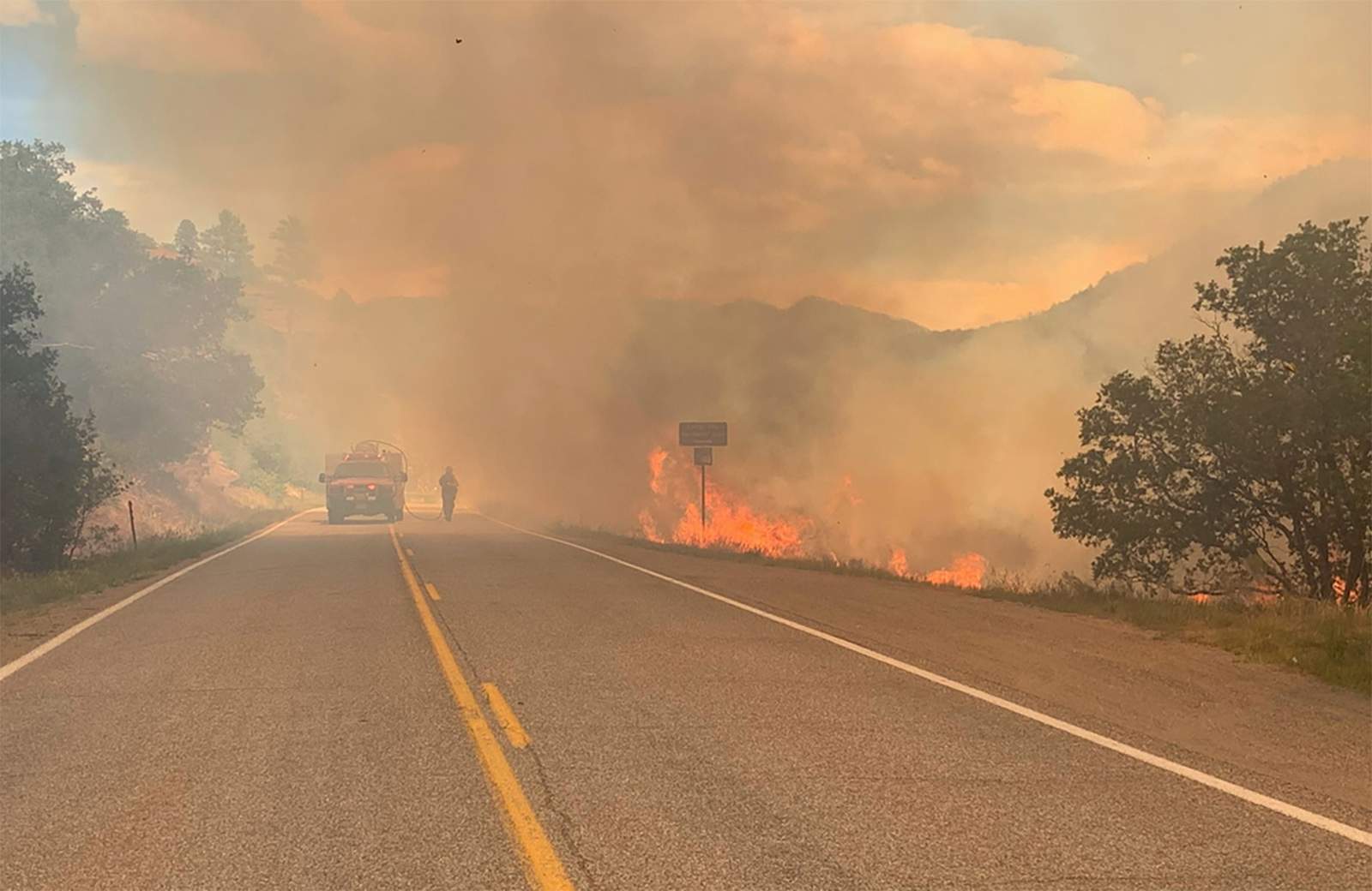
Drought is going to be a concern, heat is going to be a concern, wind is going to be a concern and fires are going to be a concern. All of those I see in our future for this summer and fall.
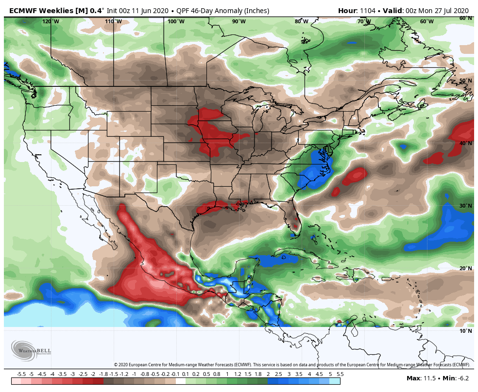
The image above is the Euro Weeklies for QPF Anamolies – basically a snapshot of what areas are likely to see above or below average precipitation for this time of year based on the timeframe. The image displays through end of July… should this verify we can see the middle part of the United States will see very dry conditions with well below average precipitation. A lot of the areas to the East and South of Colorado are also struggling with drought so this won’t help them much either.
Additionally the CPC outlook calls for a decent probability of below average precipitation for June 2020 in the middle part of the country with equal chances across most of Colorado (July hasn’t been released yet)

One Final Thing
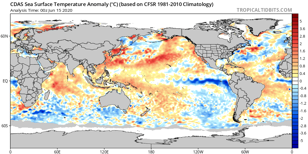
If we are going to look at the long range weather pattern we look at models, weather pattern setups, etc… but we can’t forget about our good friend ENSO. This is more commonly known to weather lay folks as El Nino or La Nina. During El Nino’s the front range of Colorado typically does well with moisture and sees a higher probability of snow storms (sometimes larger) and more active weather in spring and sometimes fall. During La Nina however, storms tend to favor the Pacific Northwest with the storm track staying pretty stoutly to our North.
There is growing chat in the Meteorological community that La Nina is forming (see the blue colors off the coast of South America in the image below) and could establish into the late summer/fall seasons. ENSO patterns don’t effect Colorado too much in the summer so we would look for other things in the near term but this could help us get a preview of what fall could be like and it may not be pretty.
I shudder to think about a hot, dry fall after a scorching hot, dry summer – we will see if this is in the cards.
Summary
All signs are pointing to a continuation of hot and dry conditions for a good portion of Colorado this summer. Remember, we will still see periodic thunderstorms with rain here and there, but without weeks or months of that consistently and without those being widespread – it won’t be enough to break our drought. Be prepared for rapidly dwindling water supplies and for increased fire danger as we move later into the summer.
Remember – we don’t do gloom and doom; but we do believe in giving folks a heads up so they’re prepared for the worst case scenario should it pan out.
