What is a “Monsoon?”
The term monsoon is one that most people associate with areas in India and Asia seasonal increases (or decreases) of precipitation, but there are several parts of the world that experience what we call a monsoon throughout different parts of the year. In addition to Asia, Australia, Africa, Europe and both North and South America experience a seasonal monsoon with varying degrees of intensity.
We could talk about all of those but the truth is they are all a bit different from each other due to differences in ocean temperature, amount of sunlight and terrain. For today we will stick primarily to the monsoon experienced in the Southwestern United States in summer.
Each year, the monsoon in the Southwestern United States begins in Mexico and Arizona…
A monsoon in its simplest terms is a season reversal of traditional wind patterns that can effect weather and more specifically precipitation. But what causes the prevailing winds to reverse in the first place?
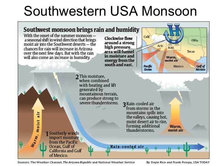
It all comes down to an imbalance of heating between the ocean and land. During the summer months strong heating occurs on both the landmass and the ocean; rocks, dirt, sand and to an extent grass thermally conduct the heat back into the atmosphere allowing the air to heat and expand in those areas more than over ocean areas. This causes low pressure to build over the landmass while high pressure develops over the ocean just off-shore as ocean temperatures remain relatively stable in comparison to what’s going on over the land.
These pressure differences cause sea breezes to blow inland carrying moisture-laiden air over the landmass. In our case, that air gets lifted as it moves upward in elevation towards and over the Rocky Mountains. As we know from basic weather 101; what happens to air with a lot of moisture when you lift it into the atmosphere? You see an uptick in showers and thunderstorms – cooler air can’t hold as much moisture as warmer air. Remember our basic ingredients for thunderstorms!
The Southwestern United Status Monsoon
The North American Monsoon also called the North Mexico, Southwestern U.S. or Arizona monsoon describes the pattern shift we see in mid to late summer across the United States. It’s a delicate dance of upper level low and high pressure systems along with upper and mid level winds that change the overall weather pattern for a good portion of the Western and Southwestern United States. Here’s a few factoids about the monsoon and how it sets up for Colorado.
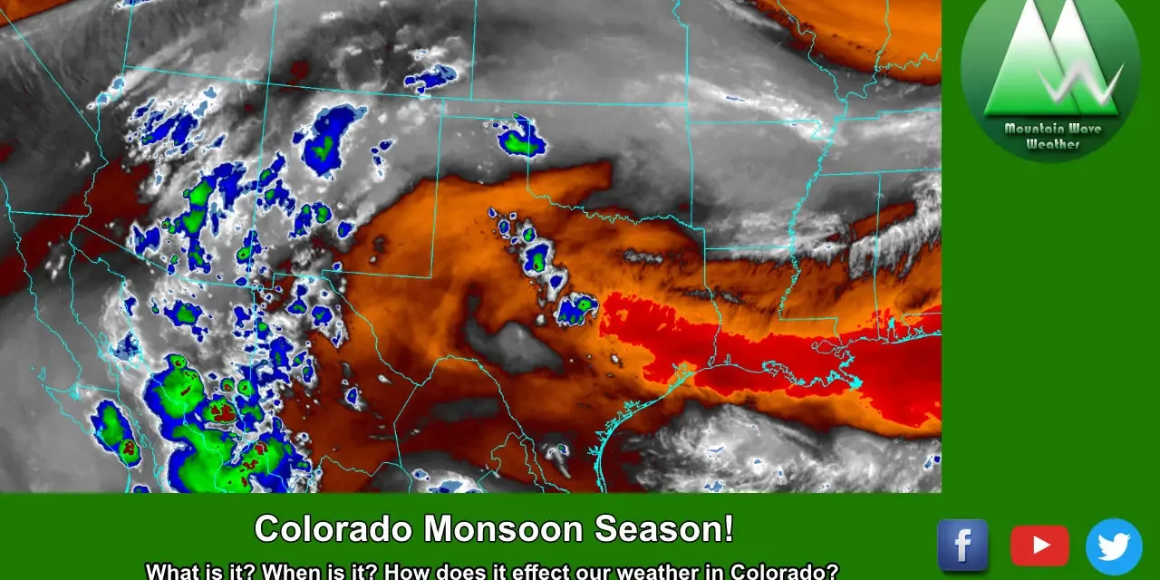
Colorado Monsoon Season
- Timing
- Early July through Mid/late August
- Add or subtract a week or two to each time frame, the monsoon can establish early or run late but the early July through late August is the most common time to see the effects
- Increased Precipitation
- Yes, but not widespread. Afternoon thunderstorms become more numerous and more moisture enters the atmosphere, but due to lack of steering winds aloft (shear) storm characteristics are mainly heavy rain and sometimes hail. Thunderstorms are more of the “pulse” variety and tend to grow and die quickly (this can give the storms the appearance of “hopping” or “missing” areas
- Severe Weather
- Flash flooding from heavy rain becomes the primary threat
- We do see an uptick in hail with storms during monsoon season, it’s almost a second hail season for Colorado
- Tornadoes are rare but can still happen, typically we see a big drop-off of tornado activity after the end of June in Colorado
Colorado’s Rainy Season
In Colorado we tend to see an uptick in precipitation through the form of afternoon thunderstorms in the afternoon during our monsoon season. As I said above though, the precipitation isn’t widespread and generally depends on which areas see the most consistent thunderstorm activity so it can be hit or miss sometimes. In general though, most areas see higher precipitation in July and August on average.
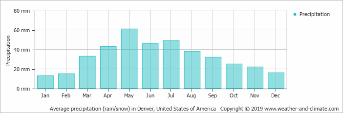
Average precipitation by month for Denver, Colorado. Notice the uptick in July and August; this is due to the summer monsoon
Mechanics Behind the Southwestern Monsoon
High pressure to Colorado’s East and low pressure to Colorado’s Southwest funnels warm and and moisture into the state – the higher terrain/mountains helps lift those ingredients to form thunderstorms
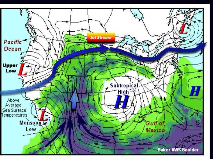
Like many of our weather patterns in Colorado, the monsoon is a delicate dance of high and low pressure systems along with the jet stream and upper level winds. All of these need to set up in just the right place make the perfect monsoon setup. Since these areas are not static and tend to wobble back and forth over the course of hours or days – we can sometimes see days with lots of storms and other days with hardly any at all.
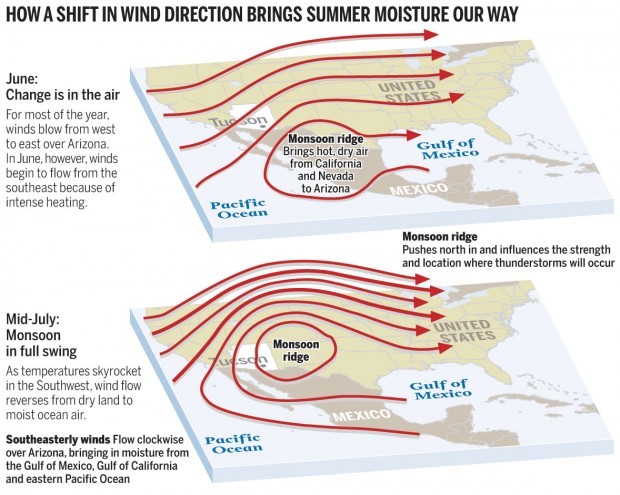
During the summer, we often see a high pressure called the subtropical high establish over the midwest which pushes air outwards in a clockwise direction. This is an important feature of our monsoon as it is the primary mechanism responsible for transporting moisture from the Gulf of Mexico up into Colorado. The southerly and Southeasterly winds can also aid to upslope our storms against the higher terrain.
Meanwhile a low pressure system sets up over Southern California or the Baja region and pushes wind around that center in a counterclockwise fashion. You can see how the two systems funnel warm air and moisture from the Gulf of Mexico or the Baja region through Arizona and New Mexico into Colorado. The higher terrain in the Mountain West plays a part as it helps to lift that heat and moisture and form thunderstorms. The higher terrain can also help this energy break through any capping in the atmosphere which would also hinder thunderstorm development.
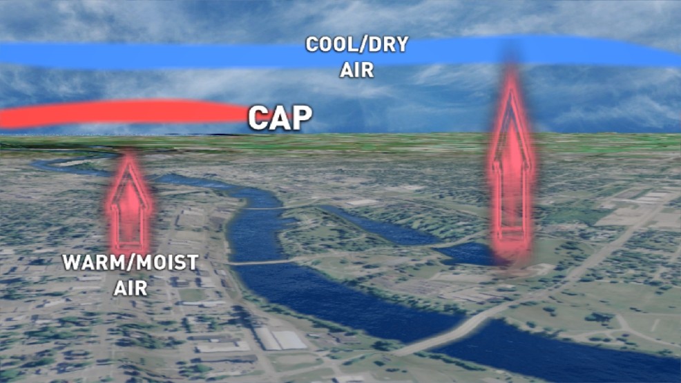
As we move later into the summer, capping inversions become more common. This is like a “lid” on the atmosphere and any warm/moist air needs an extra lifting mechanism to help that energy push up into the atmosphere.
Flash Flooding
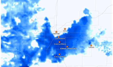
By far the biggest severe weather threat we see during the monsoon season is flash flooding.
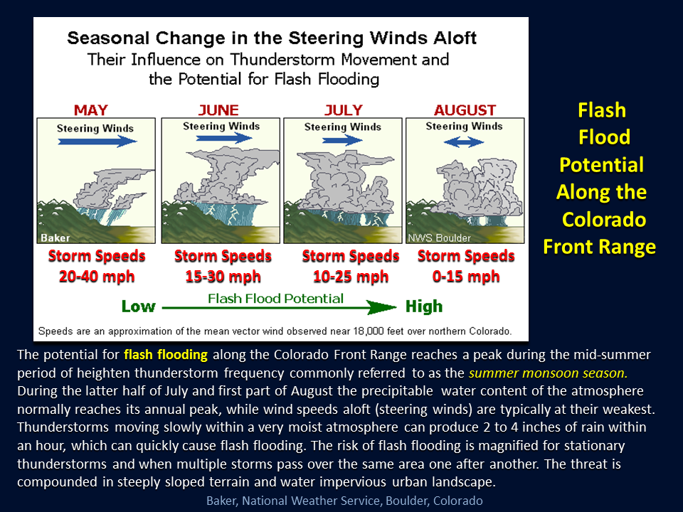
Why is that you ask? As you can see from the graphic above; we tend to see a lot of moisture in the atmosphere and when these thunderstorms for they don’t have a lot of wind aloft to push them along. This means storms form with a ton of moisture and because they tend to move very slowly or sometimes hardly at all, areas underneath those storms can see a lot of rain over a longer period of time.
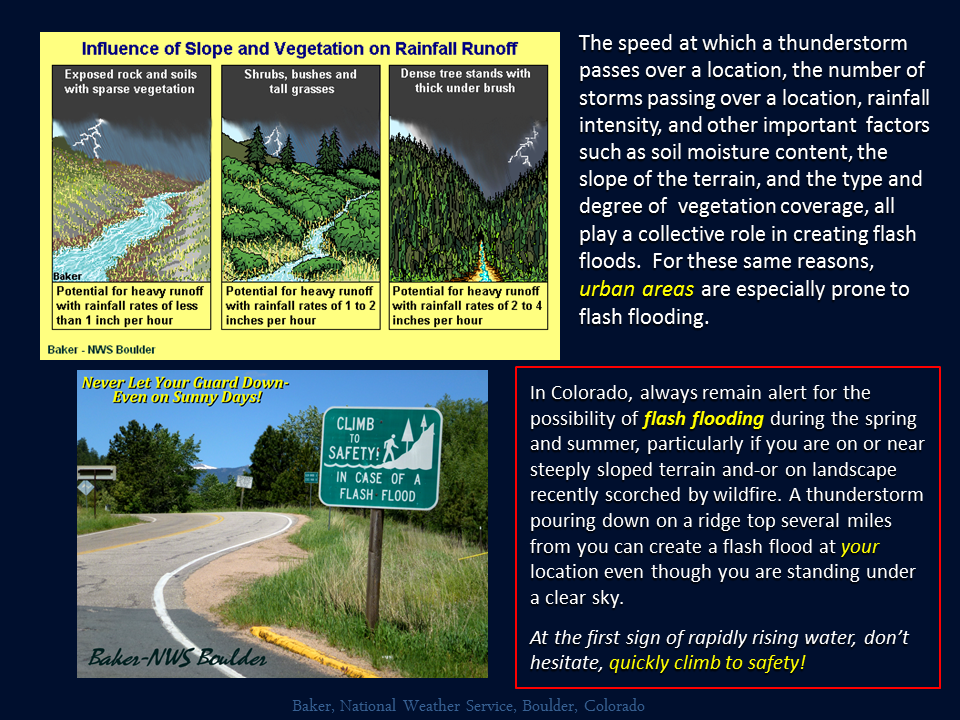
Additionally, due to higher runoff urban areas and burn scars from fires are especially prone to flash flooding. All of that water has to go somewhere so even though the weather may be fine where you are, it’s always worth paying attention to the weather and knowing if there are storms in the area. If you are in the mountains or on the plains recreating near creeks and streams this is especially important!
Monsoon 2020 Outlook
[s2If current_user_can(access_s2member_level1)]
As I’ve said several times before, long range forecasts are tricky and get much less accurate the further go out and much less detailed. Still, we can look at models and clues in the atmosphere to find a direction to “lean” towards what we think may be a bit more likely. For example, will we see a strong monsoon, average monsoon or weak monsoon and what are the chances for each?
These are a few things we are looking at in terms of what direction we are leaning towards for this year’s monsoon. It’s an important forecast because Colorado is becoming increasingly dry with drought beginning to effect much of the state. A good monsoon could be a drought buster while a normal or bad one can set the stage for fall and possibly winter.
Short Term
If we say the monsoon starts on or about on time this year we should see things beginning to form in Arizona/Mexico right now and moving to Colorado in the next 14 days or so. We take a look at the CPC 8-14 day outlook and we see:
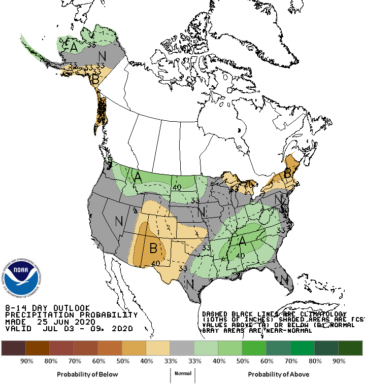
CPC probability of above or below average precipitation for next 14 days
CPC has a pretty significant probability that Colorado, New Mexico, Arizona, Utah, West Texas and Kansas remain dry over the next 2 weeks. Many of these areas are in drought conditions so this isn’t much of a surprise as we expect to stay dry in the shorter term and perhaps longer term. As we all know though, we need to dig a bit deeper to verify that more than one forecast product is seeing this signal.
Here’s the GFS total precipitation through mid July
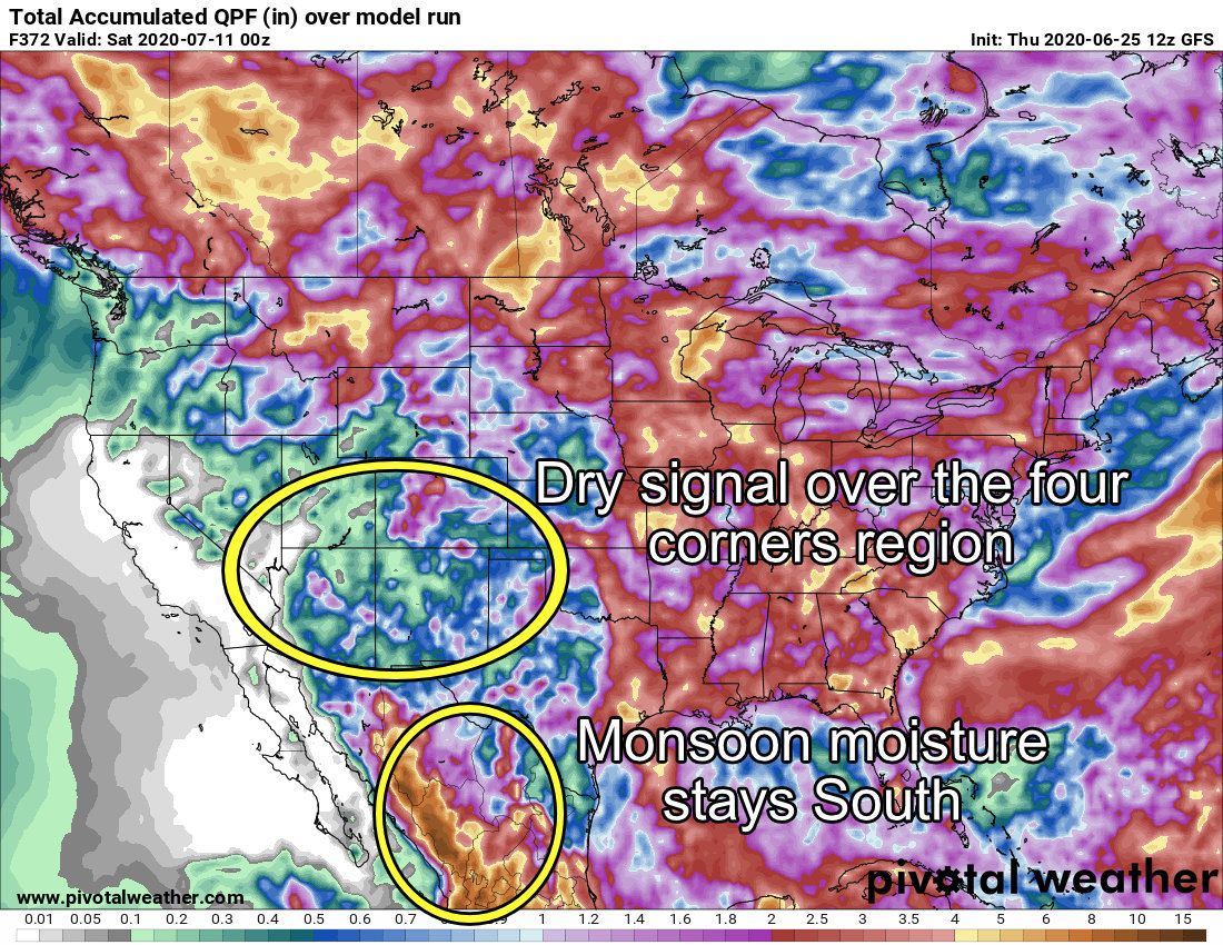
GFS total QPF through mid-July. I’ve made some notes and highlighted areas of interest
So we have to consider the above information in a Monsoon forecast this year.
Longer Term
Forecasting at this range gets tricky as models don’t go out this far and the ones that do tend to see a pretty good drop in accuracy. The point here though is you can still pick up on longer term trends and patterns so they can still be a useful tool. I tend to stick to the European model as it tends to do the best overall at a lot of different time ranges – that being said when viewing models at this range they need to be taken with a grain of salt.
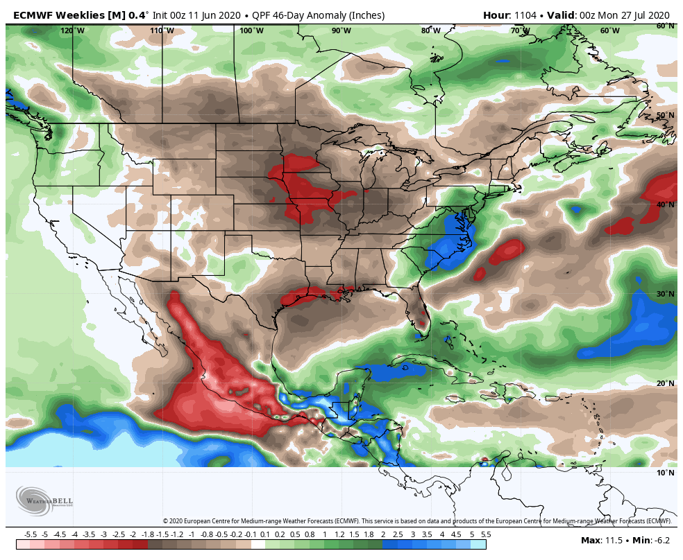
The Euro Weekly product above is from June 11 and runs total expected precipitation through the end of July. Notice that it also has a dry signal that extends through most of the Western U.S. – but notice how in contrast to the GFS, it doesn’t even have a monsoon signal at all in Mexico/Arizona/ U.S. West. This is concerning…
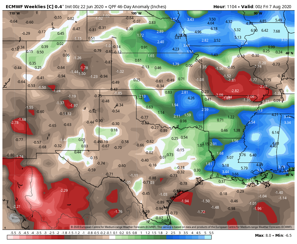
If we take the same product, zoom it in and update it a bit we see a similar trend. This snapshot above shows a continued dry signal for most of our monsoon areas but luckily a wetter signal for those off to the East of Colorado. This snapshot is updated as of June 22 so it is newer data. The dry signal that remains over Colorado is not a good sign, but the fact that we see some moisture coming into areas to our East means there may be a pattern breakdown or monsoon moisture does make it eventually into Colorado.
Things to Watch
- Monitor long range models for continued dry conditions over Colorado
- Watch for shorter term pattern changes
- Monsoon 2020 may be a late show this year?
- Late showing monsoons generally mean we stay dryer than average through the period… will have to watch
Our Consensus
It’s unlikely at this point that we see an “above average” monsoon with the data we are seeing. Most areas in Colorado are unlikely to see above average precipitation through our monsoon season. The trend leans towards two other outcomes as being more likely than a wet monsoon season; average or below average trends are more likely.
Unfortunately below average will worsen our drought across Colorado while average precipitation may be enough to keep our drought from getting worse but not make it any better.
[/s2If]
[s2If !current_user_can(access_s2member_level1)]

If you’re already a supporter, make sure to sign in to see this content!
[/s2If]
Summary
Hopefully this helps give a glimpse into what is a normal part of Colorado weather every year. It really is fascinating how the monsoon behaves year to year and what it does with Colorado’s Weather.
If you’re a site supporter – you got a special/early look at our monsoon forecast and which direction we may be leaning this year in terms of wetter, average or below average for precipitation during the period.
If you have any questions or comments feel free to leave them here on the site or ask them on my Facebook page!
