This is a fairly long post with lots of information, but this is a complex and ever evolving storm system. The below information is a compilation of all the data and forecasts we have as of this morning, but take note that there is still a decent amount of uncertainty regarding this storm. We will still be watching closely through the day Monday for any shifts in the storm’s track, timing and intensity. Any shifts could mean pretty dramatic shifts in the forecast.
Be sure to stay up to date today!
Current Weather Highlights as of This Morning 12/12/2022 8AM
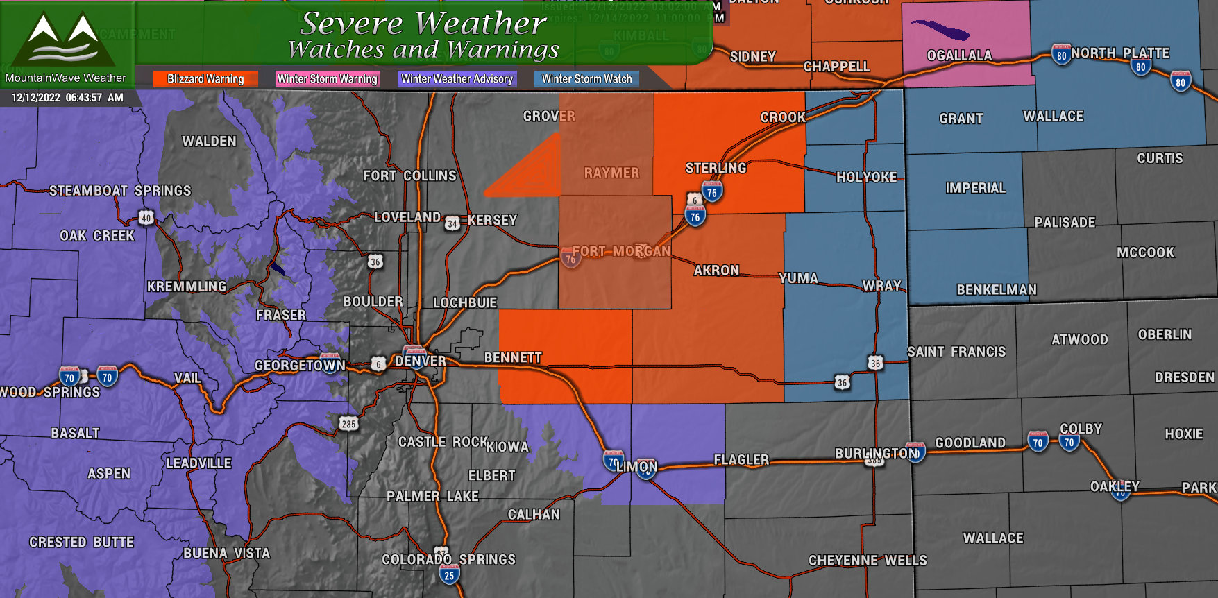
BLIZZARD WARNING IN EFFECT FROM MIDNIGHT TONIGHT TO MIDNIGHT MST
TUESDAY NIGHT…
* WHAT…Blizzard conditions expected. Total snow accumulations between 4 and 10 inches. Winds gusting as high as 60 mph.
* WHERE…Morgan County-Central and East Adams and Arapahoe Counties-Logan County-Washington County- Including the cities of Cope, Last Chance, Crook, Peetz, Otis, Sterling, Akron, Leader, Wiggins, Byers, Goodrich, Deer Trail, Merino, Bennett, Brush, and Fort Morgan
* WHEN…From Midnight tonight to Midnight MST Tuesday Night.
* IMPACTS…Visibility will be near zero at times resulting in whiteout conditions. Travel will be treacherous and potentially life-threatening. Road closures and impassable roads are likely.
Strong winds will cause extensive drifting snow and may cause minor damage and power outages. Strong winds will continue to cause drifting snow in northeastern Colorado on Wednesday and
possibly into Thursday.
People planning travel north or east of Denver Tuesday, or those
with outdoor livestock interests should prepare for likely blizzard
conditions on Tuesday and continued cold and windy weather behind
the storm Wednesday and Thursday.
WINTER WEATHER ADVISORY IN EFFECT FROM MIDNIGHT TONIGHT TO
MIDNIGHT MST TUESDAY NIGHT…
* WHAT…Snow and blowing snow expected. Total snow accumulations between 2 and 4 inches. Winds gusting as high as 55 mph.
* WHERE… North and Northeast Elbert County Below 6000 Feet/North Lincoln County- Including the cities of Hugo, Limon, Agate, and Matheson
* WHEN…From Midnight tonight to Midnight MST Tuesday Night.
* IMPACTS…Plan on hazardous travel due to snow and blowing snow. Sharply reduced visibilities will be possible.
WINTER WEATHER ADVISORY is also in effect Monday through Wednesday for various mountain locations for heavy snow and strong winds. Expect difficult travel conditions during this time.
Timing/Impacts
Here’s a quick rundown on what to expect based on the time, day and where you live. This information has growing confidence but some of these impacts and timing may shift a bit depending on data we get in throughout the day on Monday. The forecast is still very much evolving today so stay tuned for updates!
Highest storm impacts:
- Expected Monday through Wednesday in the mountains
- On the plains and Palmer Divide expect the storm to move in late Monday night and last through mid-day to late day Tuesday
- In Denver, expect impacts late Monday night through Tuesday afternoon
Locations and Impact Types:
- Mountains
- Heavy snow, accumulations in some areas up to or over a foot (mainly in and around Steamboats and surrounding mountains)
- Strong winds, gusts to 60MPH possible
- Icy/Snowpacked roads with slick conditions
- Northeastern Plains
- Heavy snow with significant accumulation up to and over a foot in localized areas
- Strong winds between 50-60MPH
- Visibility near zero, icy roads, road closures, impassible roads
- Dangerous and life threatening travel conditions. Travel strongly discouraged in and during the blizzard warning area.
- Palmer Divide
- Some snow with light/moderate accumulation (mainly East of Douglas County)
- Strong winds between 40-50MPH (mainly East of Douglas County)
- Difficult travel conditions due to blowing snow, icy roads and poor visibility (mainly East of Douglas County)
- Denver/I-25/Urban Corridor
- Snow expected, accumulations look light at this time
- Breezy wind conditions between 20-30MPH gusts
- Some roads could become slick, mainly East of Denver
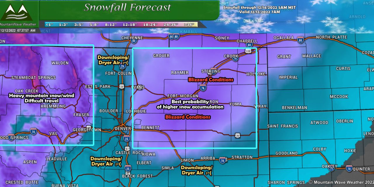
Snow Forecast
Here’s the latest on our thinking around snowfall, this could change through the day on Monday with more data but this is a good snapshot of what are seeing right now.
Palmer Divide/Denver/I-25 Corridor
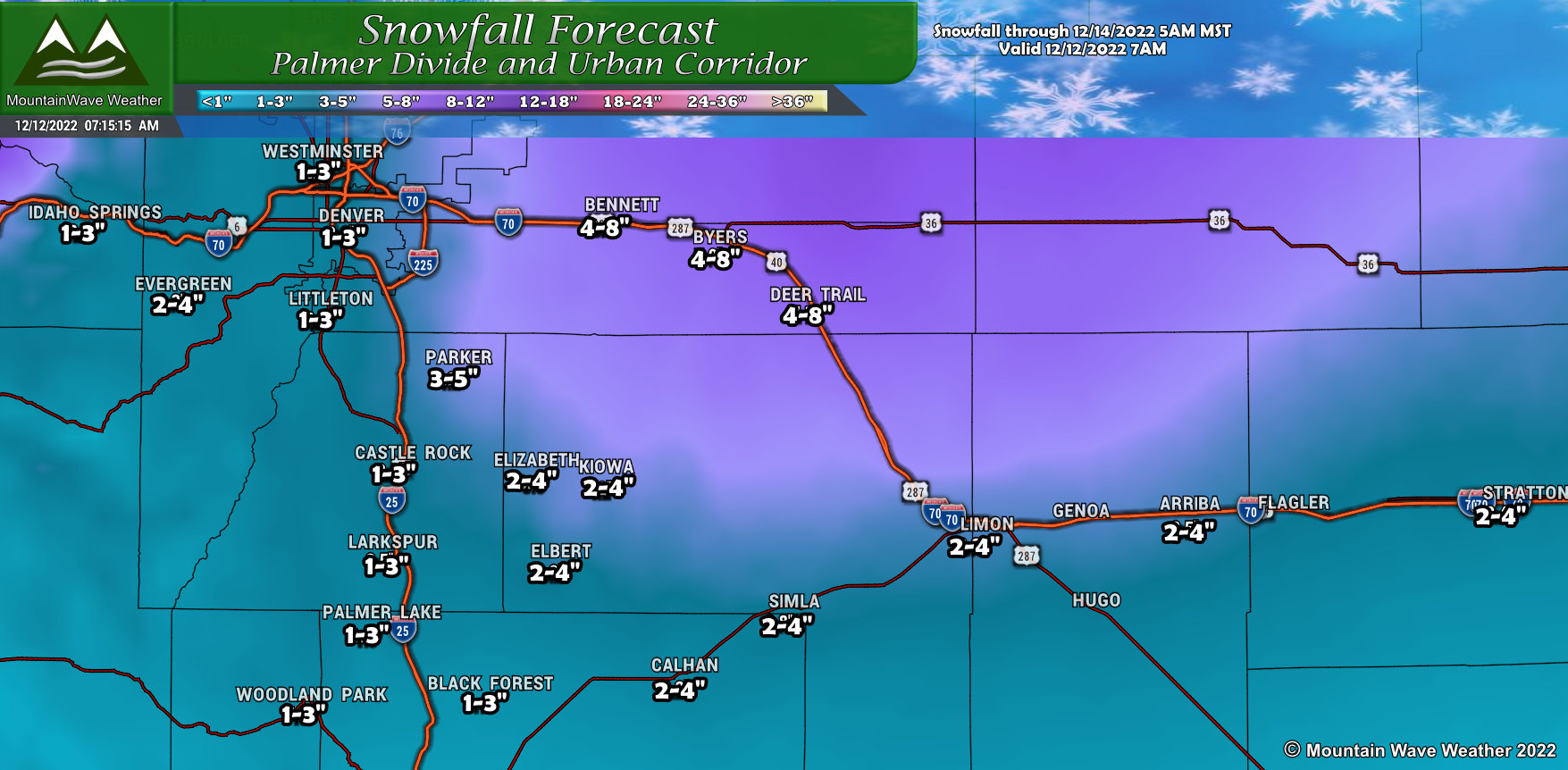
Only minor adjustments to the snow forecast along the Palmer Divide and into Denver. The general trend has been for less snowfall Westward across the I-25 corridor and against the foothills. Meanwhile for areas East of Douglas County, the higher snowfall amounts continue to creep Southward and just a tad Westward. As such, many of those snow amounts have been minorly adjusted or left alone. It doesn’t look like a high snowfall event for much of Elbert County, but the exception may be the Northern half of the county where up to 4-5″ could fall in localized areas.
Northern Colorado
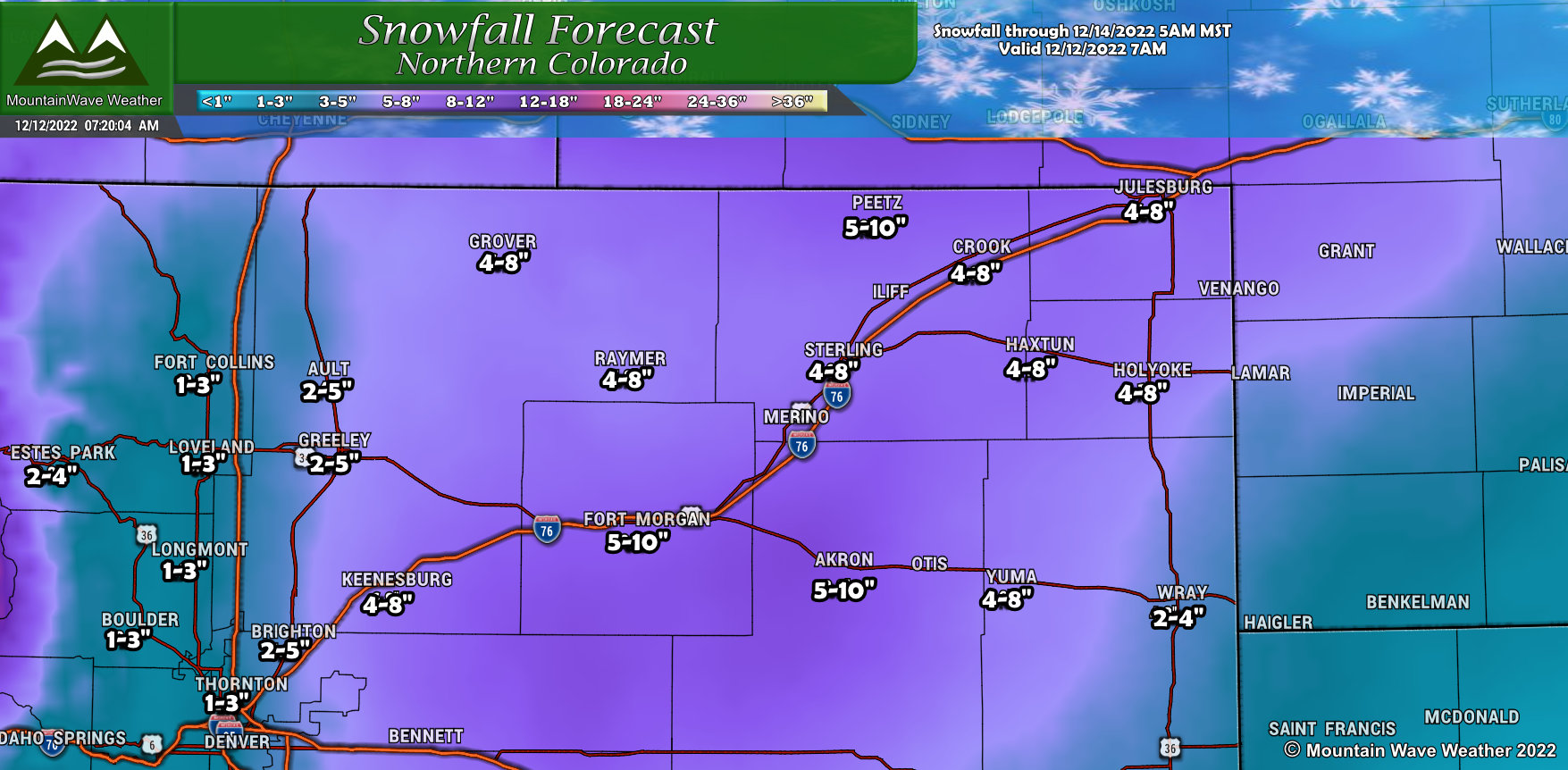
The trends for Northern Colorado have remained overall the same; the bias for heavier snowfall remains the Northeastern corner of the state East of the US85 corridor. Some slight adjustments made out East but the main adjustments are along the I-25 corridor, where snow amounts have been dropped. This is mainly due to the strong downsloping expected with Northwesterly winds expected to establish behind the storm as it strengthens and moves East. These areas may still see snow, but the window will be shorter before downslope flow dries out the air.
Northwestern Colorado
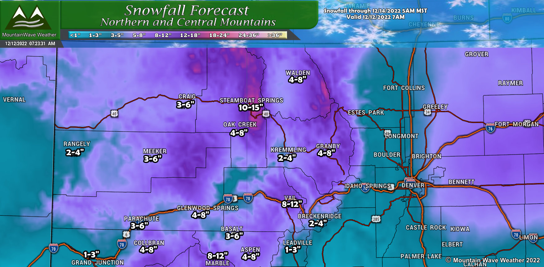
Little changes to the mountains, snowfall amounts have been adjusted slightly but the overall theme is the same… mountains will do fairly well with snow during this storm.
Southwestern Colorado
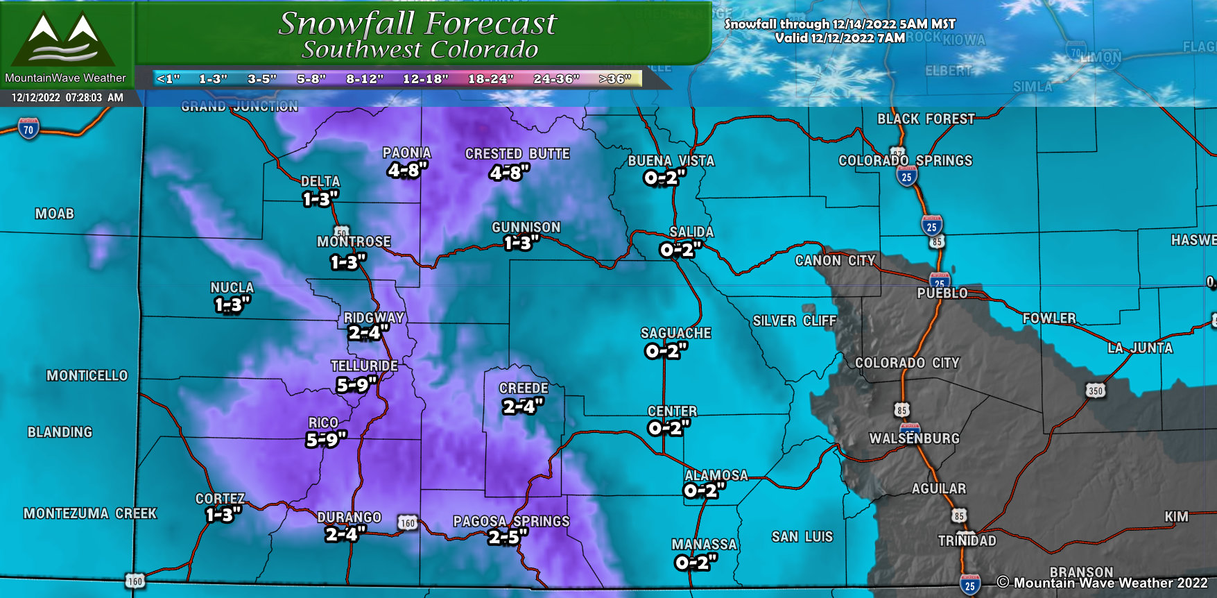
A few minor snowfall adjustments for Southwestern Colorado – forecast pretty much the same.
Southern Colorado
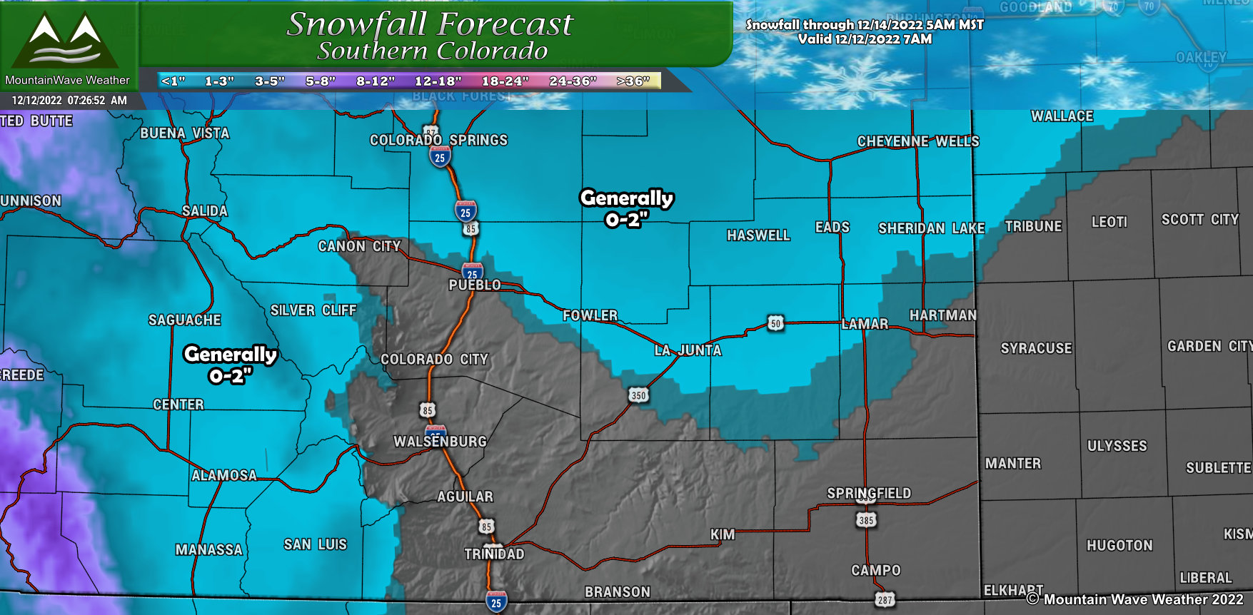
No real adjustments to snowfall in Southern Colorado, we are not expecting lots of (if any) snowfall in most areas of Southern Colorado.
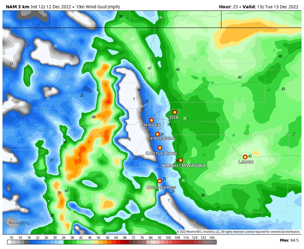
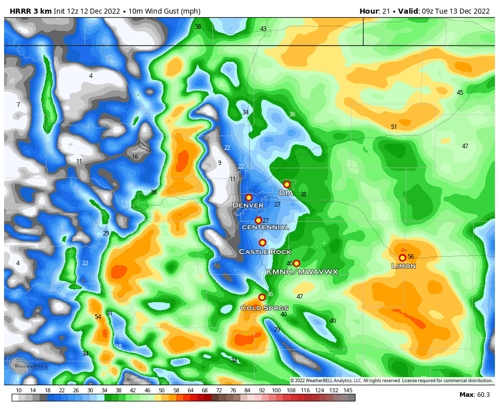
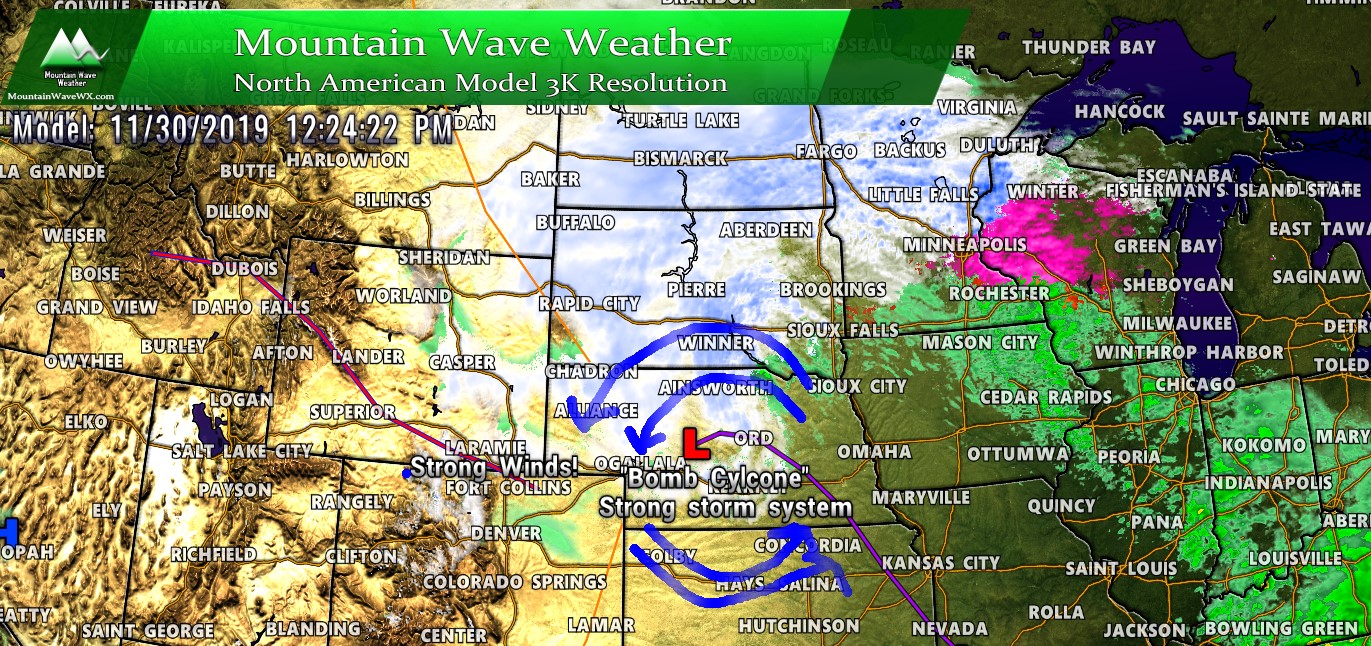
Strong Winds Likely for Eastern Colorado
I’ve attached a couple of model runs with cities filled in to give you an idea of where the strongest winds are most likely to be. Again, you’ll see the bias is to areas East of Douglas County, East of Denver, the Northeastern corner of the state and areas in and East of Limon.
Nam3K
 HRRR
HRRR
Summary
All of the important information about what, where, when and what to do (preparedness) so I wont’ repeat that here. Instead I’ll simply say that this storm is still wobbling a bit in the models so there is still some uncertainty associated with all of this.
The models will continue to do what they do today, but now that the storm is over Utah this morning, we will have to watch and see if it behaves the way models said it would. If it does, we will have growing confidence that we are on track with a forecast… if it slows down/speeds up/ is stronger or cooler than expected – that could mean our forecast needs to be changed later today.
A weather forecast is not static, it can change every couple of hours based on what data is coming in. Stay tuned for any updates throughout the day Monday and make sure to have any storm preparations completed by this evening.
