A couple of storm systems on tap over the next week with a possible third a bit later in the month. Not too excited about any of these for our neck of the woods to be honest, but here’s the latest details as of the data in tonight.
Storm # 1 12/5 – 12/7
Timeframe
- Mountains: Monday PM through Tuesday PM
- Plains: Monday PM through Tuesday AM
Impacts
- Mountains
- Areas of snow, some could be heavy over higher elevations and mountain passes. Light accumulation for most areas with moderate accumulation for those higher elevation peaks and passes. Expect some travel impacts from slick roads and windy conditions.
- Plains
- Mainly gusty winds, especially East and Southeast of Denver
- Much cooler temperatures, highs on Monday in lower 40’s for Denver, upper 30’s for most Palmer Divide locations.
- No snow expected (see snowfall forecast below)
Snowfall Forecast
As with many storm systems we’ve seen this year, we don’t see evidence that the storm track will be favorable for any decent amounts of snow East of the Continental Divide. The good news is the first storm we are scoping out this week will bring many mountain areas some beneficial snowfall to try and boost our ailing snowpack. Most areas will end up in the 1-3″ or 2’4″ range but a few select high elevation peaks and passes could end up with amounts in the 4-8″ range.
Best chance areas to see those higher snowfall amounts are in and around Steamboat Springs, especially the Park Range just East of town. Other areas that may benefit the best from this storm includes the Flat Tops North of Glenwood Springs and the Elk Range between Crested Butte and Aspen (although we expect higher totals to be more spotty this far South.)
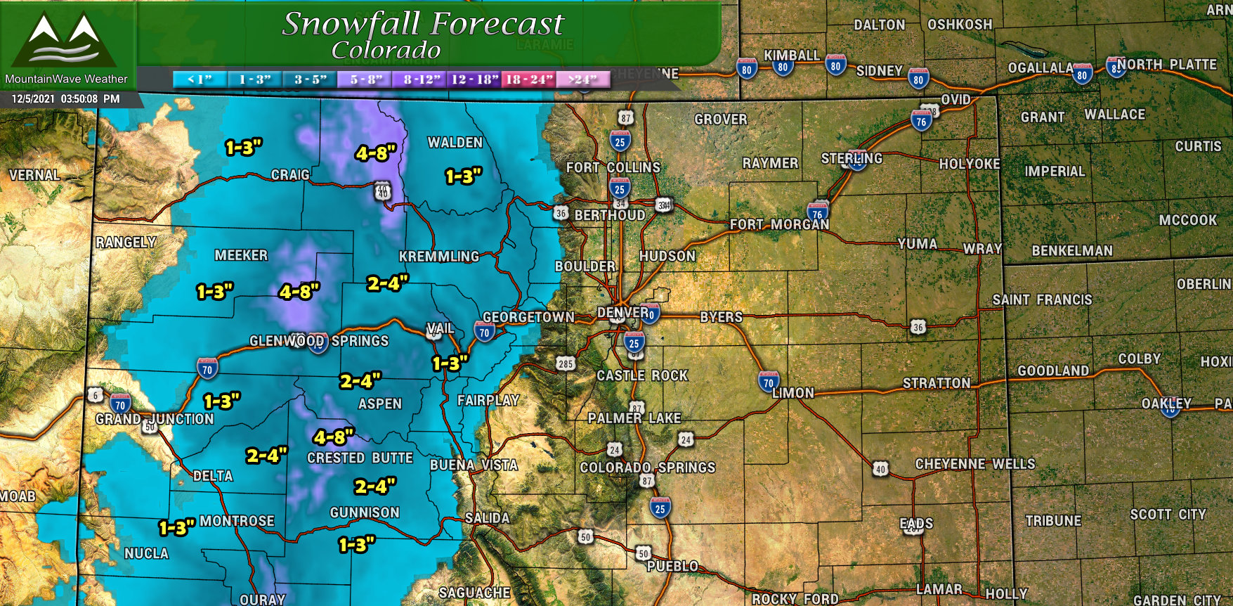
Colorado snowfall forecast through Weds 5AM 12/8/2021
So while we are not expecting snow out of this storm for us along the Palmer Divide, urban corridor and Eastern Plains, some of us will have some wind to deal with. That being said, most areas won’t encounter wind nearly as strong as we saw on Sunday. The higher wind gusts (20-25mph) will occur East of Denver and the I-25 corridor and South and East of Castle Rock along the Palmer Divide. Again, these winds won’t be strong enough to do much of anything, but they will combine with colder temperature to make things chilly on Monday especially.
By Tuesday we see the winds relax a bit and temperature rebound back to near 50.
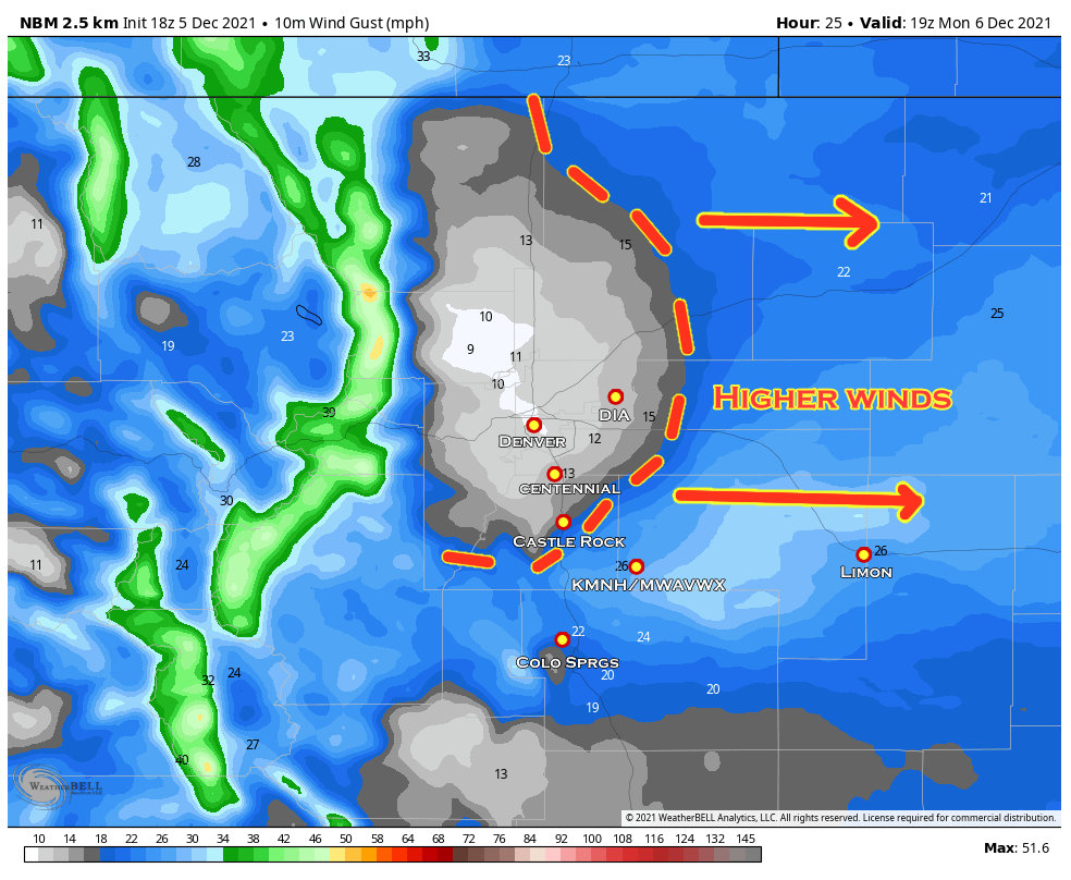
National Blend of Models 10m wind gust for 12PM on Monday.
Summary on this storm: outside of the mountain areas outlined above, this storm really won’t be that exciting. Colder temperatures and winds will be the main impacts East of the Divide but we don’t anticipate any snow out of this one for the Front Range or Palmer Divide.
Storm # 2 12/9 – 12/11
As this storm is still roughly a week out, we don’t yet have the finer details on which areas will see snow and exactly what the impacts will be. As such, I’ve posted information below on the timeframes we are watching and some of the storm details we will keep an eye on. Here’s the latest and remember there will still be a lot of wiggling back and forth in terms of the forecast over the next few days:
Timeframe
- Mountains: Thursday AM through Saturday AM
- Plains: Thursday PM through Friday PM or Saturday AM
Model Snowfall Forecasts
*Remember, models do not equal forecasts. They are a tool to help build a forecast, there are other factors that go into building a forecast beyond models, but at this point in a forecast it is always good to get an idea of what they are thinking. Remember, model snapshots should always be provided with context.
–We are still only in range of the Euro and GFS so those will be shown until we get into range of the medium/higher resolution models…
GFS
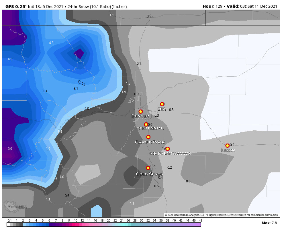
GFS 24 hour snowfall from late Friday night
Euro
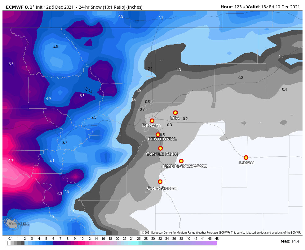
Euro 24 hour snowfall from Friday morning
Model/Forecast Talking Points
- You’ll notice the difference in timeframes used on the model snapshots above. That’s because at this point, the two models don’t agree on timing of this storm system very well. As you know, that can make all the difference as the moisture, cold and upslope needs to combine at the right time to generate snow across the front range and palmer divide. This is one trend we will have to watch
- There are still differences in snowfall between the models. The Euro is more bullish on snowfall especially in the mountains, but brings less snow across the plains. The GFS is less excited overall with lower snow amounts.
- The one thing models agree on is snow along the front range but very light accumulations. We will see if that trend goes upwards or downwards as the week goes on.
My two cents; while I’m excited to see snow chances in our forecast by end of week/next weekend… I don’t see a whole lot of evidence that the snow accumulation will be anything to write home about as of yet. That could change as we move through the week, we’re still far enough out. I’m just commenting on what I see in the data tonight.
Storm # 3 12/20ish?
Not going to get into much details with this one yet but there are chances for another storm system to move through somewhere around 12/20.
We are so far out, models have very little agreement on any aspect of this storm so I’m not going to comment on it just yet.
This is more of a “keep an eye” on it it situation. I’ll have more details on this storm system as we get closer to that date.
