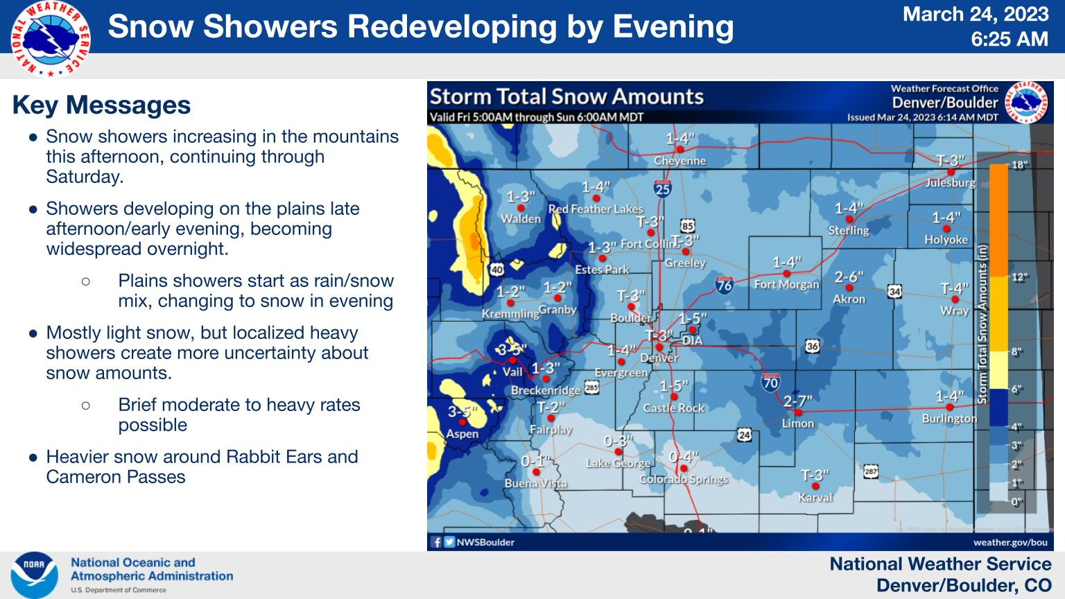
Current Colorado Weather Highlights
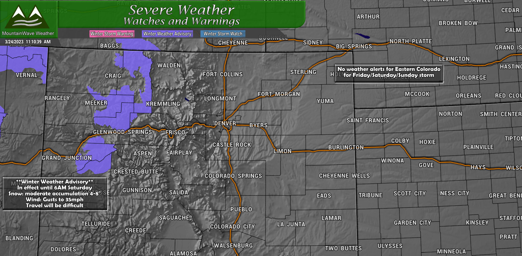
Currently the only winter weather highlights in the state of Colorado are in the Western mountains near Glenwood Springs and strecthinb North to Steamboat and South to just West of Crested Butte. Those areas of the mountains will see snow showers add up to around 4-8 inches of fresh snow through 6AM on Saturday. Wind gusts up to 35mph may make for slick roads and poor visibility at times – plan on difficult travel in these areas for the rest of the day Friday and early into Saturday morning.
There are currently no weather highlights for Eastern Colorado regarding the next storm moving through Friday/Saturday and Sunday.
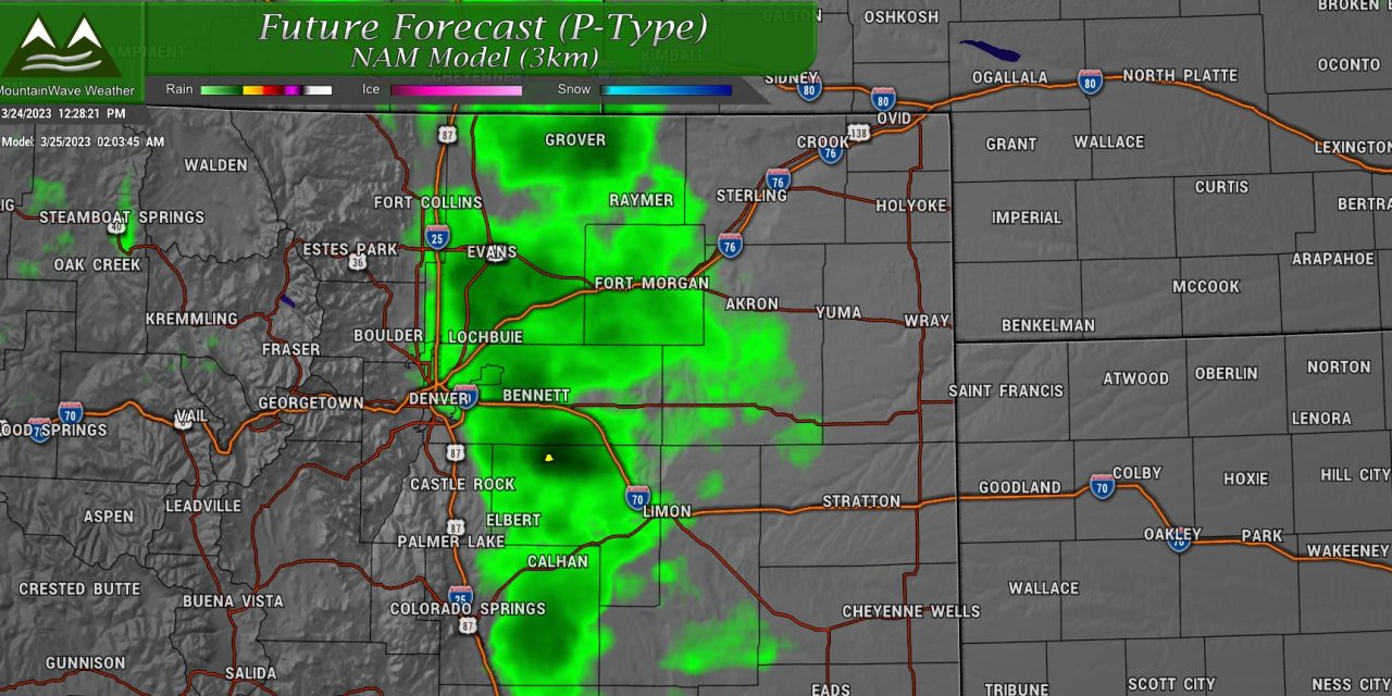
Tricky Snowfall Forecast on Tap
When are they not tricky? As we move later into March, we have to start considering more variables in a snowfall forecast, mainly the increased sun angle that promotes melting and warmer ground temperatures that do the same. Those two points will factor into this storm but there is one more monkey-wrench to throw in with this storm: our old friend – snow bands… ugh.
Storms like this are not typically huge snow producers, but the totals can vary drastically over short geographic distances and also vary depending on if the snow bands set up and how intense they are. If any of that doesn’t come together, you’ve got a lot of busted forecasts.
Here’s an illustration with the Palmer Divide:
Palmer Divide Snowfall Forecast (Snow band doesn’t set up, moves through too quickly or is weaker in intensity – gives us less than expected snowfall forecast)
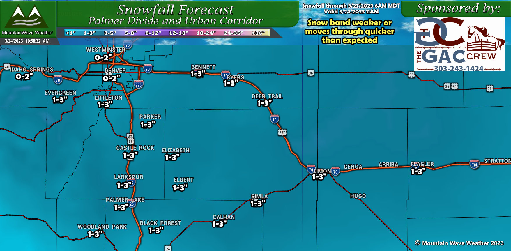
As you can see, mainly light snowfall for most areas along the Palmer Divide and Front Range Foothills. This would give us a low end forecast for Castle Rock as 1 inch for example with a high end at 3 inches.
Let’s look at scenario 2:
Palmer Divide Snowfall Forecast (Snow band sets up, is stronger in intensity and doesn’t move through too quick – higher end snowfall forecast)
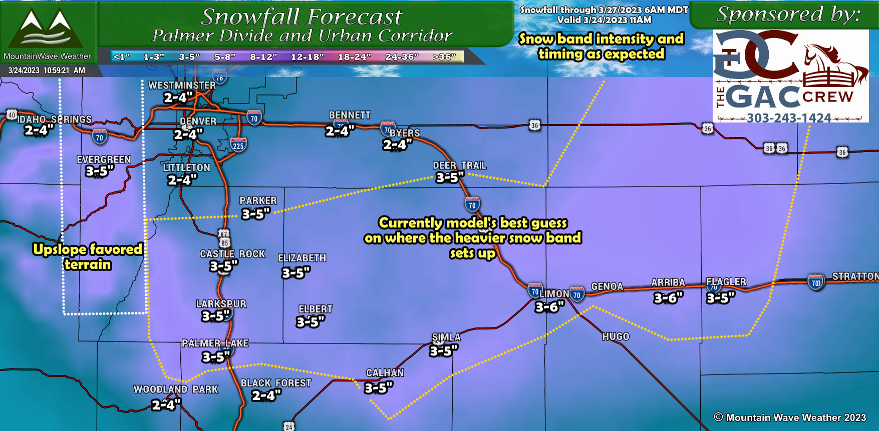 I’ve highlighted the area the models are most consistent about with where the snow band sets up and anchors for a bit. If this scenario were to verify, some areas would see a higher end of 5-6″ of snow. The kicker here is models are good at showing a snow band is likely but rarely nail the location, timing and intensity – makes them very difficult to forecast.
Should this band shift a bit North, Denver could get hammered while places like Castle Rock and Larkspur could see very little.
It produces some pretty wide snowfall forecast numbers, but that has to happen when we have such high uncertainty as we do with this storm. The National Weather Service went all in with the full range on their latest forecast:
 1-5 inches for Castle Rock is a pretty wide spread, so is 2 to 7 inches for Limon! Considering the uncertainty around that snow band that moves through with the front later tonight and how much lift we get – I don’t think we’ll be able to narrow down that range a whole lot more unless we get much better agreement from the models.
For now, prepare for a 70% chance of a light/minor snowfall event and a 30% chance of a moderate snowfall event along the Palmer Divide.
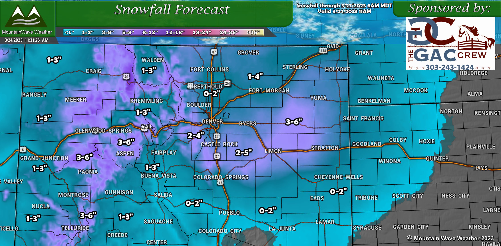
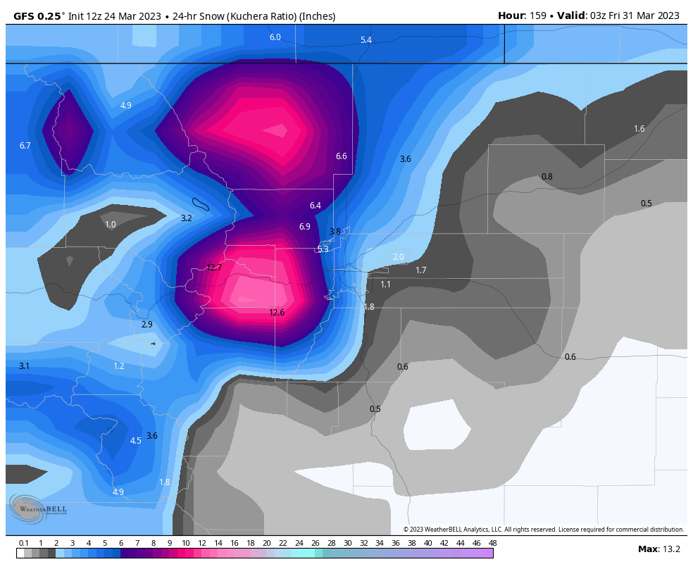
Snowfall Forecast (Rest of Colorado)
As this won’t be a major snow event for most, here’s just a quick look at possible snowfall totals for other parts of the state:
Timing and Impacts
Our timing and impact graphic below should give you a decent idea of when we are expecting the best chances for snow, cold temperatures and any possible travel impacts.
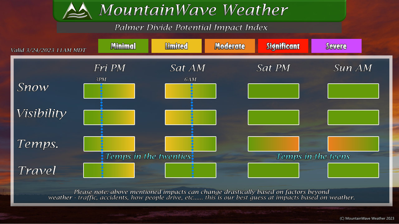
Best shot at snow comes for later Friday through early Saturday morning for the Palmer Divide. Temperatures will be chilly tonight with lows in the twenties, but Saturday and Sunday night could both see lows in the teens (moderate impact outlined.)
I don’t have room for Sunday PM but there’s another short-wave moving through late Sunday that will likely add to the snow a bit. That snow has been factored into most of my snowfall forecasts shown above so don’t expect all of that to fall on Friday/Saturday but I believe most of it will – unless something changes.
Another Storm Next Week Is Being Closely Watched
Site supporters, as a thank you for supporting this site and what I do, here’s a sneak peak on a storm system next week that has my eye! Make sure you login to see that content!
If you’re not a site supporter and want to become one, you can sign up here!
[s2If current_user_can(access_s2member_level1)]
Thoughts on Next Week’s Storm
Like so many storms this March, it’s hard to get too excited about this one just yet. There are a few things that have piqued my interest and regardless of what we see in the models right now, there is at least POTENTIAL with this storm to be a larger event. We won’t really be able to tell though for several more days.
Here’s what we have at the moment:
Timing: looks to be the middle of the week, next week. Right around March 29 +/- -a day or so.
Big Storm Potential?: The storm system is showing to be quite powerful on the longer range models but there are a few things working against it for us to see bigger snowfall or impacts
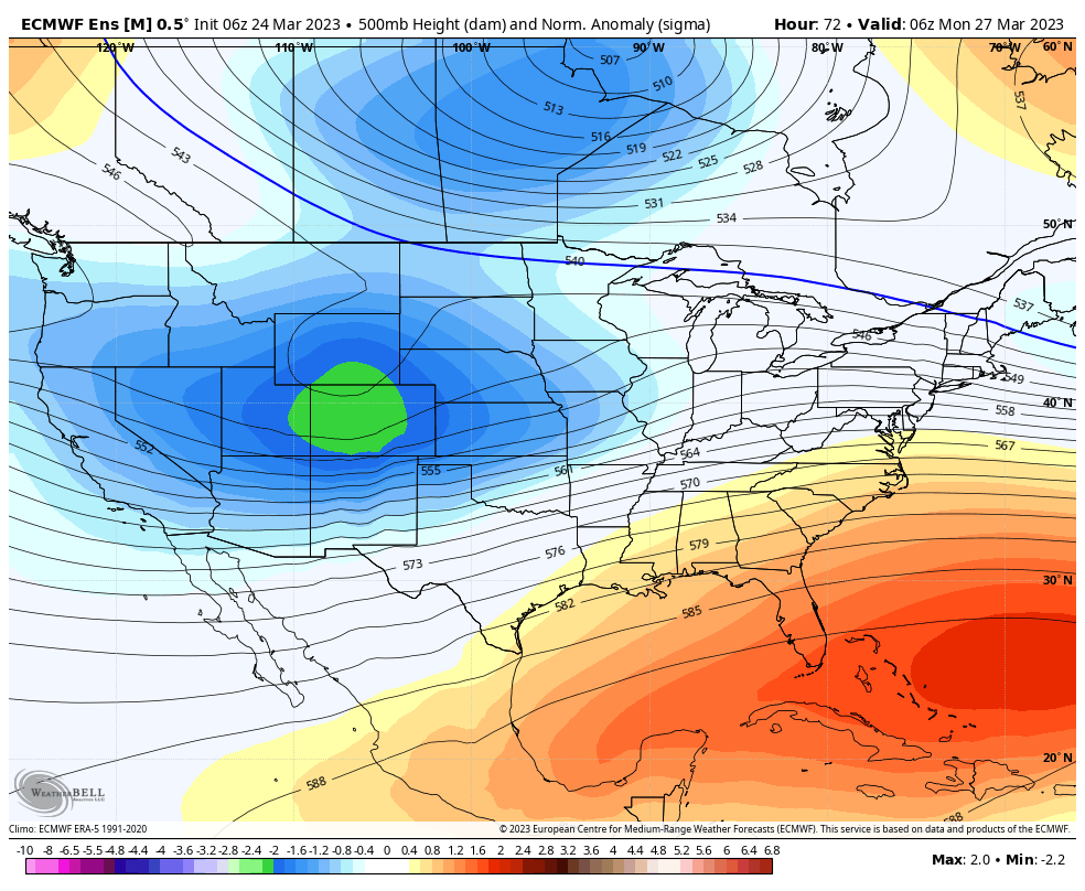
Above is a shot from the Euro ensemble as the storm winds up over the Western part of the state late on Monday.
What this storm has working for it:
- Strong storm system coming out of the West
- Positioning brings plenty of cold air in from the North while the possibility of tapping additional moisture from the Gulf of Mexico
- With the strong cold front/ cold air, precipitation type would likely be snow
What gives me pause on this storm:
- Ensembles have the energy moving too far North for us – this would bring us more of a wind event and less of a precipitation event
- The lifecycle phase of the storm has it weakening as it crosses the mountains and not re-generating out on the plains. Would like to see some evidence of this before I get too excited about this storm
- Temperatures could be marginal depending on if the storm can tap into that cold air or not
Here’s an interesting shot from the GFS:
 IT shows a pretty sharp dividing line between the colder temperatures at higher altitudes vs the warmer temperatures out on the plains.
*Remember, that is a model NOT A FORECAST!*
The model snapshot overall shows me some things I like and some I don’t.
The main messaging with next week’s storm:
- I am intrigued by the POTENTIAL that exists with the storm, but a lot will have to line up just right
- I’m NOT EXCITED yet about the storm – there is still too much uncertainty
For now, know that there is something coming down the pipe towards the middle of next week. Stay tuned for additional updates over the coming days!
[/s2If]
[s2If !current_user_can(access_s2member_level1)]

[/s2If]
