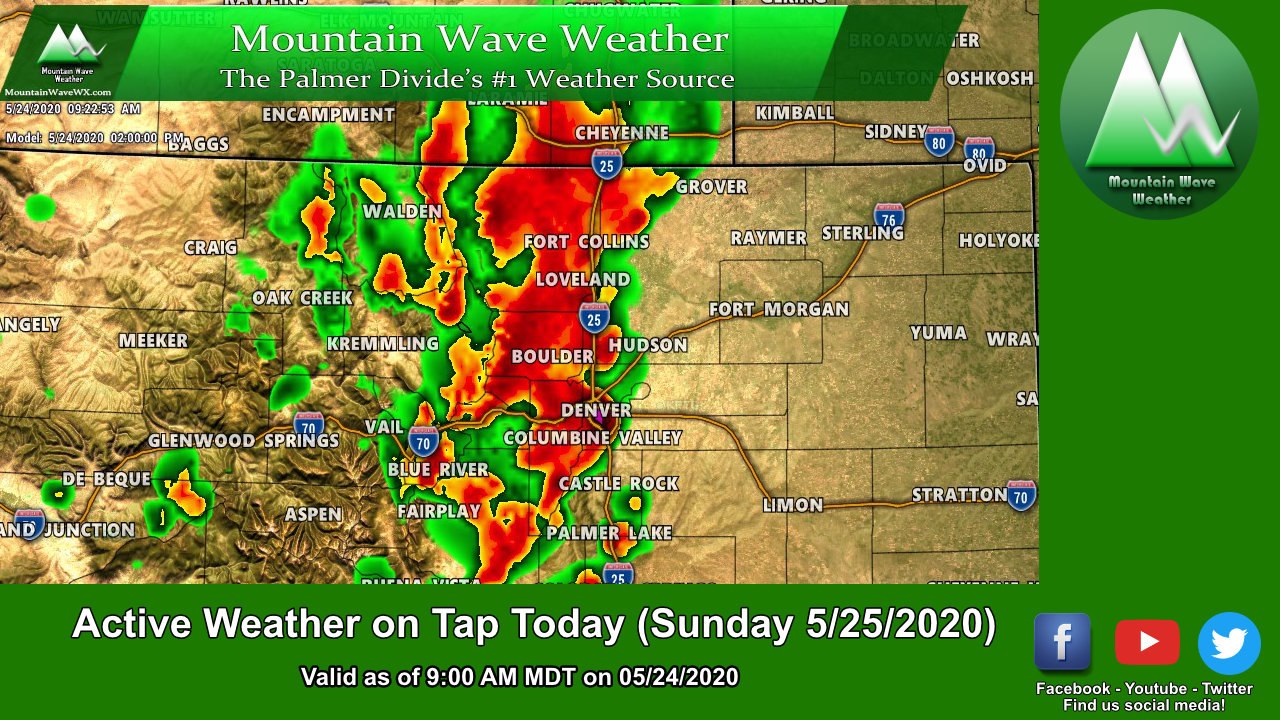
A strong storm system is lining up to our West this morning and as it swings through it will provide a good shot of rain for most areas this afternoon and event a slight chance of strong or severe thunderstorms as well. The good news is nearly all areas across the Palmer Divide will see some type of precipitation and some areas may see a decent amount… sorely needed after how warm and dry we’ve been as of late.
Here’s what we’re watching today…
Severe Weather Threat
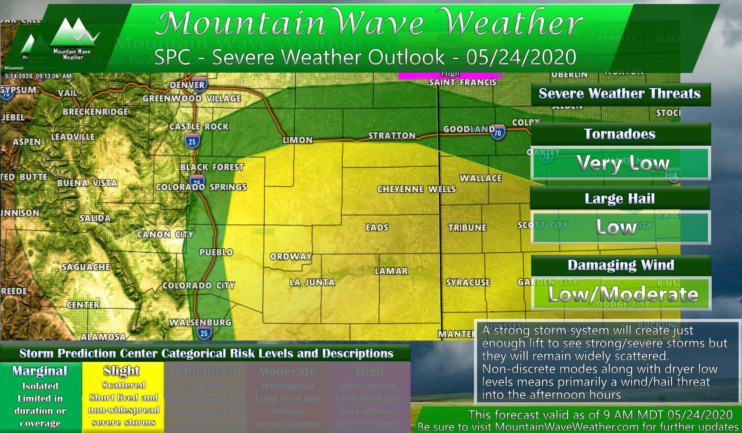
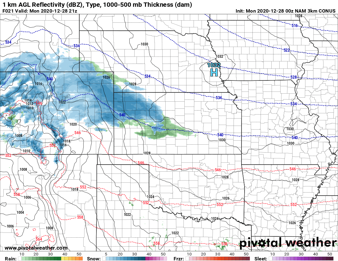
The Storm Prediction Center has slight and moderate risk areas across mainly Eastern and Southeastern Colorado today. Looking at a lot of the modeling I don’t see a lot of evidence of discreet thunderstorms (means instead of storms firing by themselves, they will form in clusters together) which means the tornado risk is generally low. Additionally, because of the big cluster of storms and the dryer air at the surface I would expect strong winds to be the primary threat out of a lot of storms with a smaller but still notable hail threat as well.
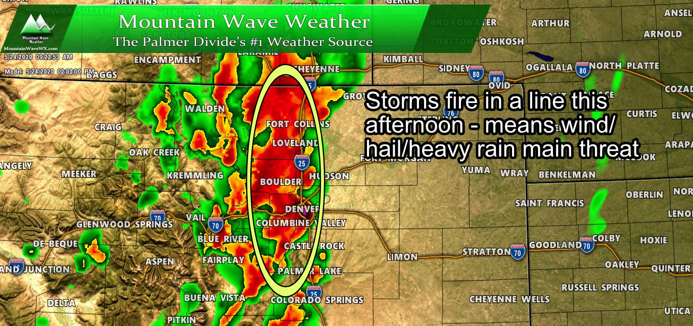
The above image is the HRRR’s thinking of what the sky will look like around 2PM. Notice the huge, long line of storms forming in the foothills and west side of Denver. Make no mistake, this is a lot of juice – these storms may lay down a lot of rain in some areas so be prepared for that. As always, thunder and lightning will accompany a lot of these storms so keep that in mind if you have outdoor plans today.
Just How Much Rain?
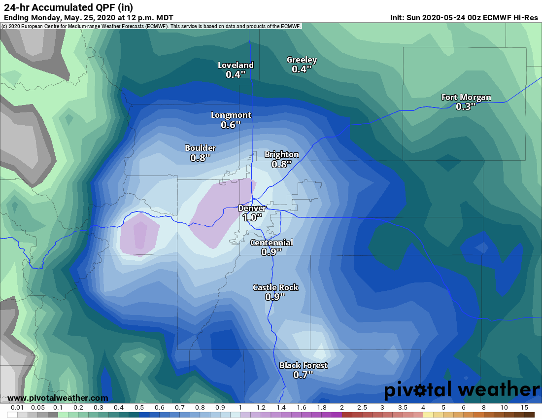
I’ll show the Euro-high res here but I could just as easily show the HRRR as they agree pretty well on where the rain hits the hardest. Most areas across Denver and into Boulder show an inch or more of precipitation by the time this storm is all said and done on Monday. I think the areas in and North/Northwest of Denver see the best shot for heaviest rain overall. Meanwhile closer to home, the Palmer Divide will see slightly less, but 0.8 – 1.1 inches of precipitation is a pretty healthy amount for our area overall.
That being said, with what I’m seeing on the models I wouldn’t be surprised if the Palmer Divide area busted a bit low on this one… all the bigger storm clusters seem to stay around and North of Denver with the rain/storms taking more of a scattered nature as you go South along the Palmer Divide. We will still see a good shot at rain, but wouldn’t be surprised if our totals come up significantly less than Denver and areas to its North.
What About Snow?
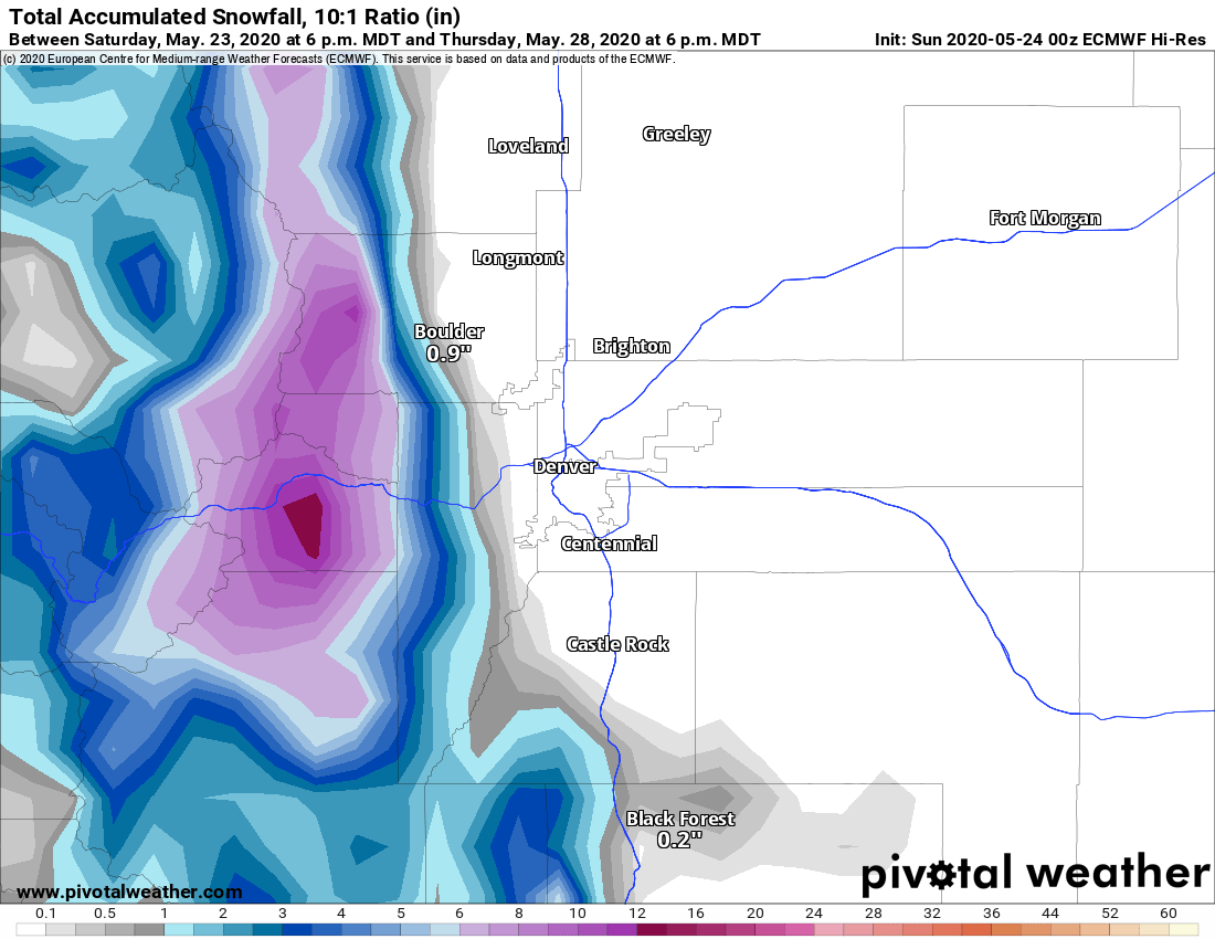
I don’t see snow accumulation for most of the Palmer Divide, but you’ll notice the areas Southwest of Castle Rock and West of the Springs do show a quick inch or two of accumulation. While it will be chilly tonight I don’t think areas below about 8,000 feet have a good chance of snow accumulation. That being said, look at how close the snow line gets on the Euro model above… anything can happen!
Not to be a buzzkill but for what it’s worth… the HRRR shows no snow for any areas South of Denver except for along Pikes Peak… I’d tend to lean that way for now.
Last Bit – The Temperatures
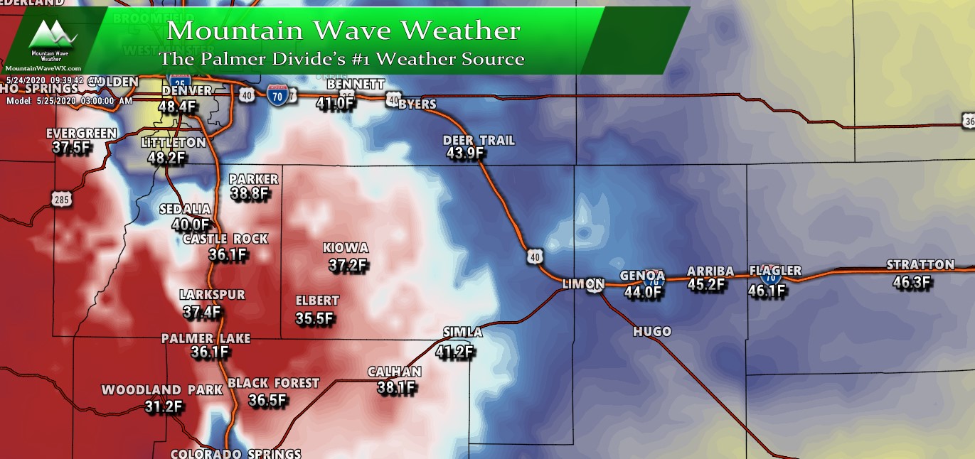
The other main story will be the cold and we expect a chilly night especially along the Palmer Divide. Low temperatures will bottom out in the mid to low 30’s for many areas tonight. Notice how Denver stays warmer though, the colder air really looks to entrench itself along the higher elevation areas. Those areas West of the I-25 corridor (Woodland Park, Pikes Peak, Palmer Lake, etc…) may see conditions below freezing.
Summary – The Rundown
So quite an eclectic mix of weather we have on tap this afternoon and tonight, here’s the quick bullet points of what to expect/be prepared for:
- Outdoor plans Sunday afternoon?
- Be prepared to move indoors, we expect storms to fire after 12PM
- Thunder and lightning will be possible along with heavy rain
- Further East into Elbert County/ SE and E Colorado – some storms may become strong to severe with wind and hail the primary threats
- Cannot rule out an isolated Tornado threat due to wind interaction with terrain and boundary setup (mainly Elbert County and points East and Southeast)
- Sunday night
- Very chilly temperatures with most locations along the Palmer Divide bottoming out in the low to mid 30’s
- Areas close to Denver and lower in elevation should see low temperatures in upper 30’s to lower 40’s
- We don’t expect a freeze at this time (be on the lookout for updates in case this changes)
- Definitely a good idea to cover more sensitive plants tonight if you’re above 6,000 feet elevation
- Sprinkler systems should be ok
We will keep an eye on things and update as necessary. If you’re out East or Southeast of the I-25 corridor (Douglas/Elbert county line and points East) expect the possibility of a somewhat bumpy afternoon with those storms. Stay tuned for any updates as necessary, otherwise happy Sunday!
