Our storm system moving through today is pretty on track in terms of the impacts we expect and who sees them. The mountains will see the bulk of the snow out of this storm and some areas could pick up some decent amounts of accumulation and travel conditions could be difficult at times through the high country. Closer to home, high winds and fire danger will be the main impacts we see along the Palmer Divide and Front Range. Here’s the latest updates on weather alerts and watches/warnings along with the updated snowfall forecast for the mountains and details on our strong winds expected along the front range.
Current Weather Alerts
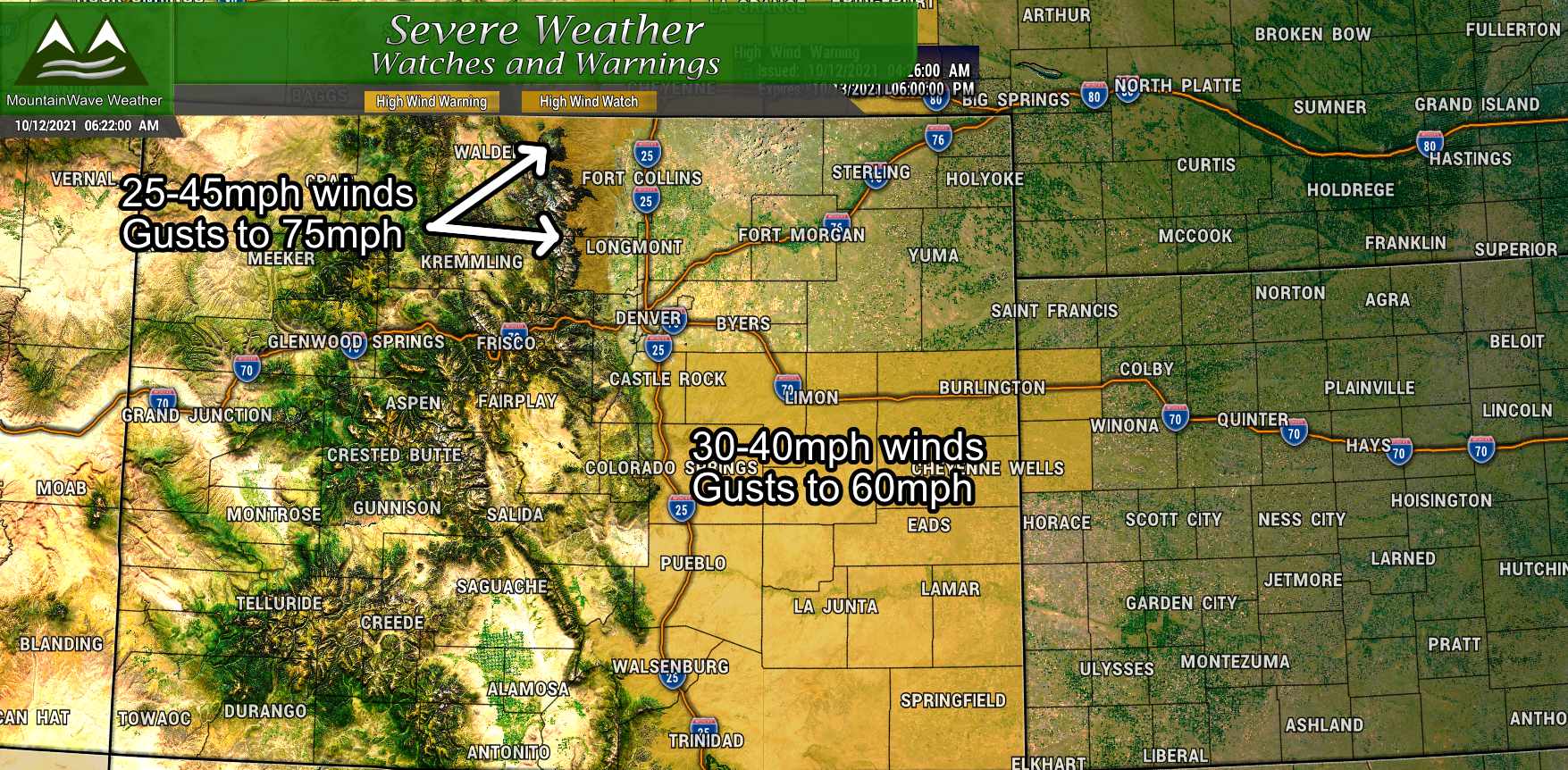
A High Wind Warning is in effect from 12PM to 6PM Tuesday October 12, 2021 for the Palmer Divide and Southeastern and Eastern Colorado.
Wind speeds: 20-40mph
Wind gusts: Up to 60mph
Impacts: Travel may be difficult for high profile vehicles, especially on East/West highways. Winds may be strong enough at times to cause property damage – be sure to have anything that can blow around tied down or put away by late Tuesday morning
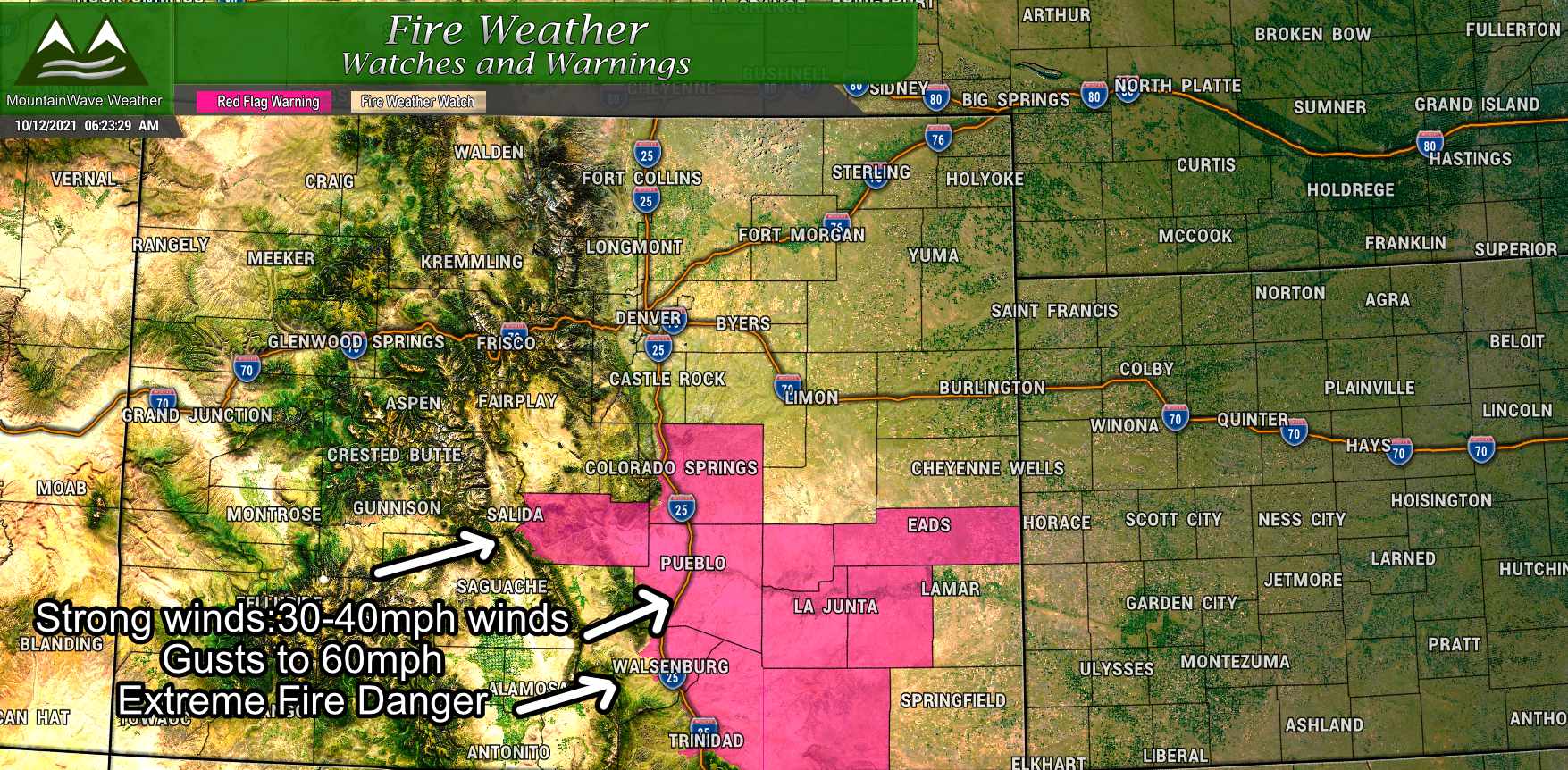
A Red Flag Warning is in effect from 12PM to 8PM Tuesday October 12, 2021 for the South Central and Southeastern and Eastern Colorado.
Wind speeds: 20-40mph
Wind gusts: Up to 60mph
Impacts: Low humidities and strong winds will contribute to rapid fire ignition and extreme fire growth. Do not burn or perform activities that could cause a spark and create a fire.
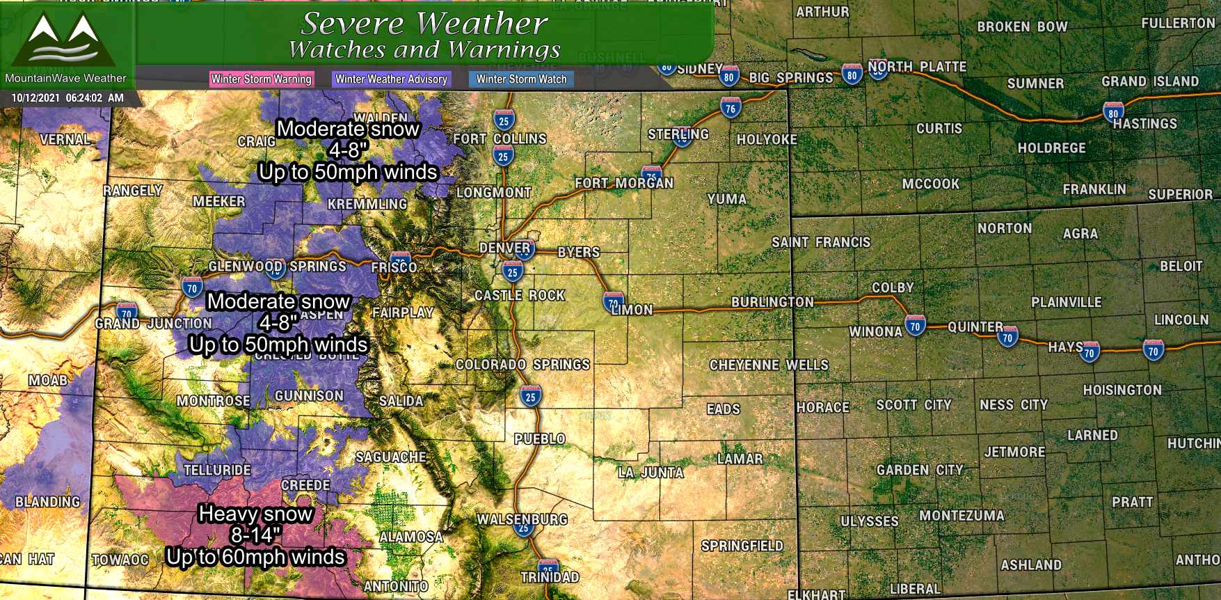
A Winter Weather Advisory is in effect from 6AM Tuesday October 12, 2021 to 6AM Wednesday October 13, 2021 for the Northern and Central Mountains of Colorado.
Snowfall: 4-8″ of snowfall accumulation expected
Winds: Gusts could approach 50mph
Impacts: A combination of blowing and falling snow along with high winds could make travel difficult at times. Be prepared for difficult winter driving conditions
A Winter Weather Advisory is in effect from 12AM to 6AM Tuesday October 12, 2021 for the Southern Mountains of Colorado.
Snowfall: 4-8″ of snowfall accumulation expected
Winds: Gusts could approach 50mph
Impacts: A combination of blowing and falling snow along with high winds could make travel difficult at times. Be prepared for difficult winter driving conditions
A Winter Storm Warning is in effect from 12AM to 6AM Tuesday October 12, 2021 for the Southern Mountains of Colorado.
Snowfall: 8-14″ of snowfall accumulation expected
Winds: Gusts could approach 60mph
Impacts: A combination of blowing and falling snow along with high winds could make travel nearly impossible at times. Travel is not recommended
Snowfall Forecast
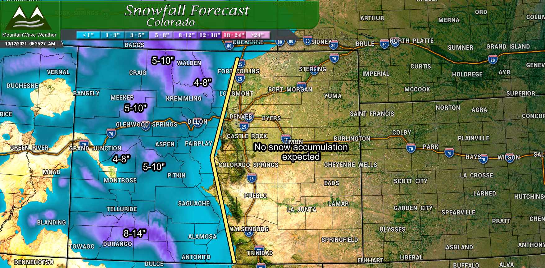
Not a lot of changes here to what we have been saying the past few days. The mountains will see the snow with this storm, some higher peaks in Northwest and Central Colorado could end up in the 5-10″ range for snow accumulation. Towards the Southwest in the San Juans, some areas could end up in the 8-14″ range with heavy snow and strong winds in that area.
Elsewhere outside of those areas, snowfall will range from the 2-4″ or 3-6″ range depending on which valley or hills you are located in.
Winds/Impacts for Palmer Divide and Front Range
The big story for us along the Palmer Divide and Front Range will be the strong and potentially damaging wind gusts. I’ve taken a peak at the latest models from this morning and my forecast is in pretty good agreement with what they show compared to what I see based on how this storm system is tracking and what side of the storm we are ending up on.
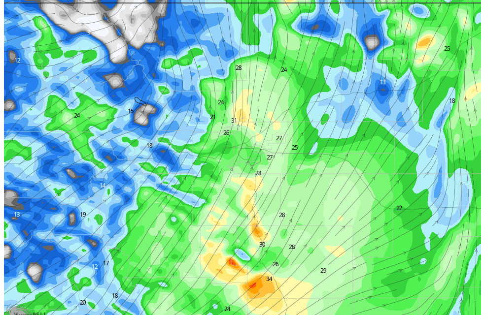
Here’s a couple of snapshots from the HRRR model for max wind gusts this afternoon:
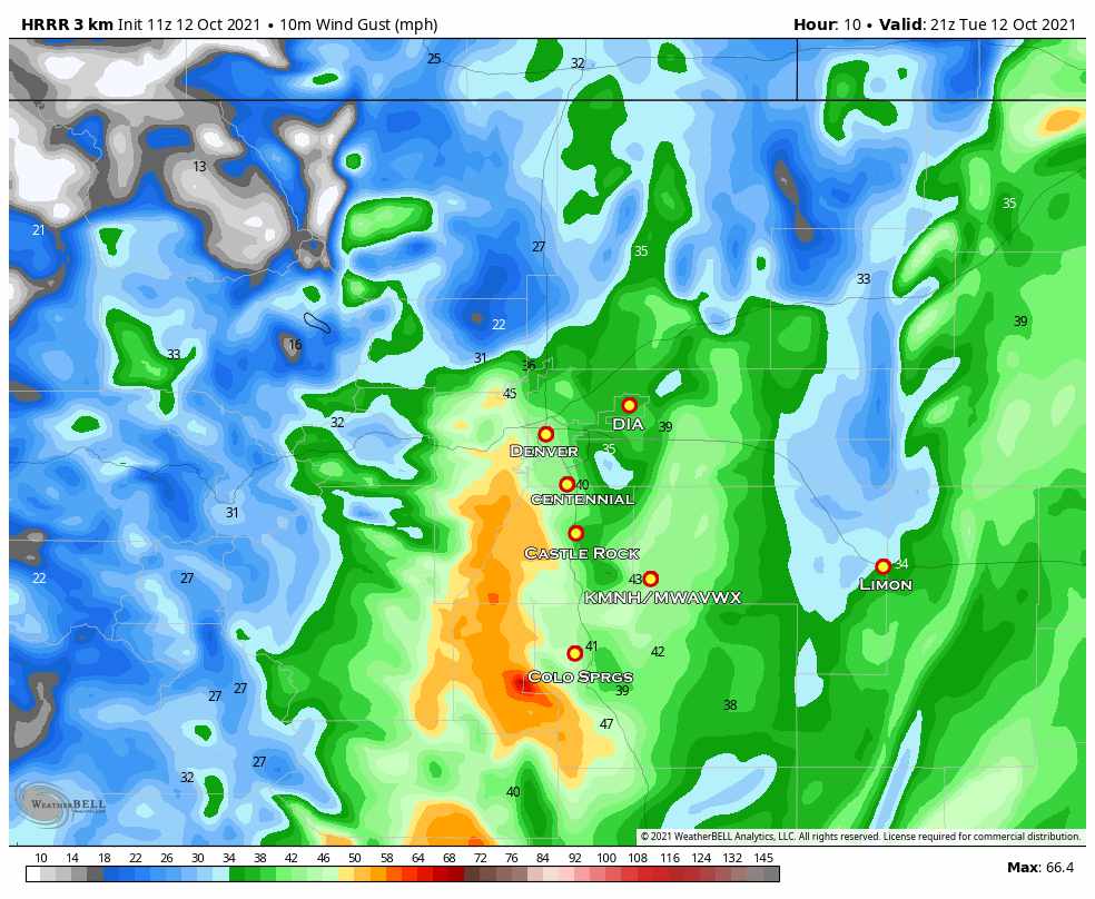
HRRR forecast wind gusts around 3PM today
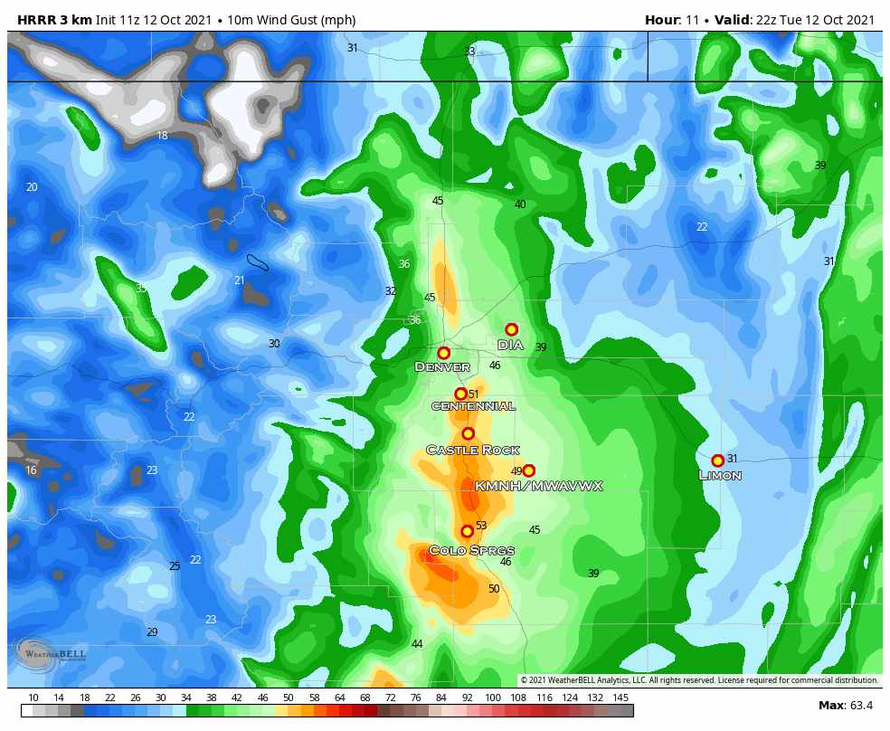
HRRR forecast wind gusts around 4PM today
As you can see, wind gusts start out earlier in the afternoon within the 30-40mph range. By later in the day (late afternoon/early evening) winds really pick up especially along the I-25 corridor South of Denver towards Colorado Springs. By that time, we could see wind gusts in the 50-60mph range, this will make travel a bit difficult over the Palmer Divide between Castle Rock and Colorado Springs.
Preparation
- Tie down or bring inside any lightweight items that could blow away in strong winds
- Be prepared for low visibility from blowing dust
- Travel may be tricky due to strong winds and limited visibility
Timing
- Strongest winds look to occur between 2PM and 7PM along the Palmer Divide and Front Range
- Mountain locations are already experiencing light snow, heavier snow will fill in throughout the afternoon and into the overnight hours
Summary
Not a ton of changes to this forecast and it’s pretty much here at this point – as such this will probably be the last major update with this storm system. If anything else looks “out of sorts” I’ll pass those updates along on the Facebook Page.
Another storm system is right on the heals of this one and will bring more “wintery” impacts our way in terms of freezing temperatures and possibly snow. Models are still showing light snow accumulation for areas above 6,000 feet in elevation as of this morning.
I’ll have an update on that storm either later today or early Wednesday morning depending on when I can get the time to do so. Stay tuned!
