An interesting day on tap today as a disturbance moving through will cause enough lift, instability and wind shear to kick off a few severe thunderstorms this afternoon.

The Storm Prediction Center has a “Slight Risk” for most of Central and Eastern Colorado in yellow with a lower “Marginal Risk” area for the green areas closer to the foothills and Interstate 25. Recall, the yellow is a higher risk for severe weather but it doesn’t mean severe weather will be widespread. It simply means out of the thunderstorms that form a few of them may turn severe.
If you want to break it down in hard numbers:
Slight/Yellow Risk is a 2 out of 5 in severity
- This means if you are in the yellow area you have about a 15% chance of seeing a severe storm
- This is still a low probability but it’s not 0%
- It also means there is a 85% chance you don’t see a severe storm… so take that as you will
Marginal/Green Risk is a 1 out of 5 in severity
- This means if you are in the green area you have about a 5% chance of seeing a severe storm
- This is a very low probability but it is not 0%
- It also means there is a 95% chance you don’t see a severe storm
Sadly we don’t have the ability to predict exactly if/when your neighborhood will see a severe storm… we can only pinpoint regional areas that have a higher chance (see below)
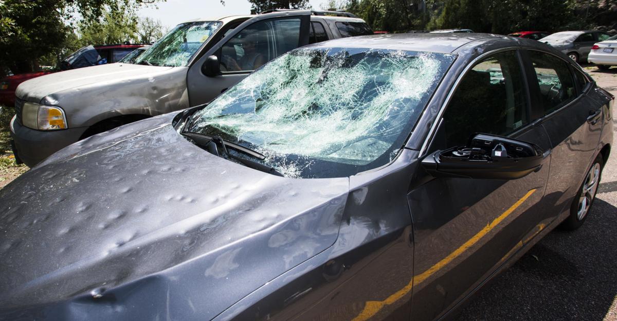
Large Damaging Hail is a Concern Today
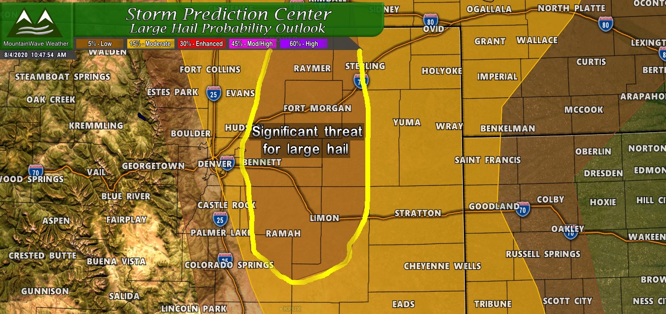
The SPC Outlook for large hail today notates areas over Eastern Weld, Eastern Adams, Eastern Arapahoe, Elbert, Northeastern El Paso and Lincoln counties as areas under risk of “Significant Hail Probability.” This means the areas highlighted in yellow above have the greatest risk of seeing significant hail today which consists of hail in excess of 2 inches in diameter.
If you live in any of these counties stay very weather aware this afternoon… not everyone will see severe storms with hail but those that do will likely see significant property damage if caught under one of these storms.
Closer to the I-25 corridor the hail threat is lower but still not 0%. Basically everyone has between a 5-15% chance of seeing some type of hail today with the shaded area seeing potentially large/severe hail.
Areas to Watch/Timing
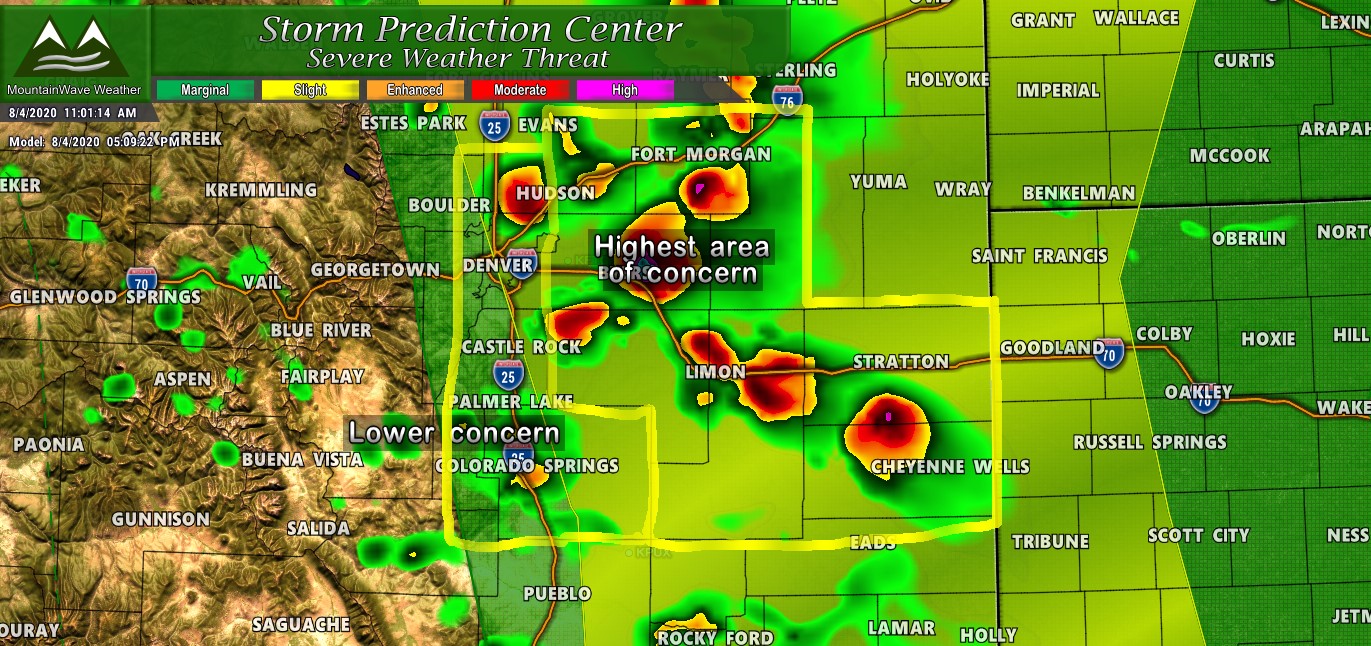
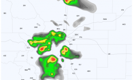
The image above is the SPC Categorical Outlook overlaid with the HRRR model reflectivity forecast for this afternoon. As we all know by now, models can’t pinpoint exact timing and locations but they can give us an overall trend of areas they think will see the worst weather. The HRRR has been consistent with bringing the areas East of I-25 the best chance for severe storms. The “Highest Area of Concern” outlined above fits pretty well with the SPC outlook’s we’ve seen and jives pretty well with their “Significant Hail Probability” outlook as seen above.
- Areas That Need To Be On Alert
- Generally the areas East of Denver, East of Castle Rock and on the Eastern Plains
- Severe weather and strong storms looks likely to initiate after 3-4PM around these areas
- Large, damaging hail will be possible (not widespread) which is why you’ll want to pay close attention to the forecast
- Areas With Lower Risk – but still need to watch
- I-25 corridor
- Palmer Divide locations West of Elbert County
- Black Forest/ Monument areas
- Colorado Springs/ Pikes Peak region
- Foothills
- These areas will need to be watched after 2PM.
We’ll Be Passing on Information/Alerts as Need This Afternoon
Latest SPC Outlook states:
...Front Range into central Great Plains...
   Although late afternoon mid-level height falls may be more subtle
   than farther north, models suggest that mixed-layer CAPE will become
   maximized on the order of 2000 J/kg, to the lee of the Front Range
   by late this afternoon.  Aided by orographic forcing and perhaps
   lift associated with a subtle mid-level impulse, thunderstorms are
   expected to initiate off the Front Range, then advect off the higher
   terrain within modest northwesterly mid-level flow.  Aided by strong
   shear, isolated supercells and organizing storm clusters are
   possible, which may pose a risk for severe hail and strong wind
   gusts into this evening.
We will be keeping an eye on things this afternoon and will pass along any information as needed. As always if you live in Castle Rock you can see real-time weather alerts on our page here.
