As we keep our eye on a large and powerful storm system next week – we are still getting data in on what this storm may potentially do. Being this far out though, we can’t give fine details in terms of how cold, how much snow, who sees snow, who doesn’t, what impacts we see, etc…
This storm will likely hit someone pretty hard next week – as to who that “someone” is… that’s still very much up in the air right now.
I know that’s not super helpful and everyone wants to know as early as possible if this storm will be a dud or be something potentially significant. I’ve put together some information below so you can understand where we are with this forecast, what we are watching for and even provided a couple of scenarios that could happen based on how this storm behaves. These scenarios don’t cover everything, the storm could shift or do something completely unexpected, but this will at least give you a glimpse of what may be possible.
Possible Scenarios
Track of this storm system will be everything. Much like a lot of our winter storms, a wobble to the North or South can mean the difference between some snow, no snow, warmer temperatures, colder temperatures, stronger winds or calmer winds. There’s a lot of things at play even at this point in the forecast as we still have several days to go. Here’s a couple of scenarios and my thoughts on which one of those scenarios is more likely with the data we have as of right now. Here’s 2 scenarios that are possible (out of several) but it helps to visualize what happens if we see a more Northern track with the storm or a more Southern track.
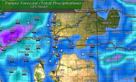
Low moves over Central and Northeastern Colorado (Most likely scenario based on today’s data – this can still change!)
In this case, the storm system would cross the mountains and rapidly intensify over the plains of Colorado as it moves into the Eastern and Northeastern part of the state. This position is not ideal for seeing much precipitation East of the Continental Divide, but it does give us plenty of something else… WIND! The mountains however, would probably pick up decent amounts of snow with this scenario and cold temperatures would help with that on the back side of this storm.
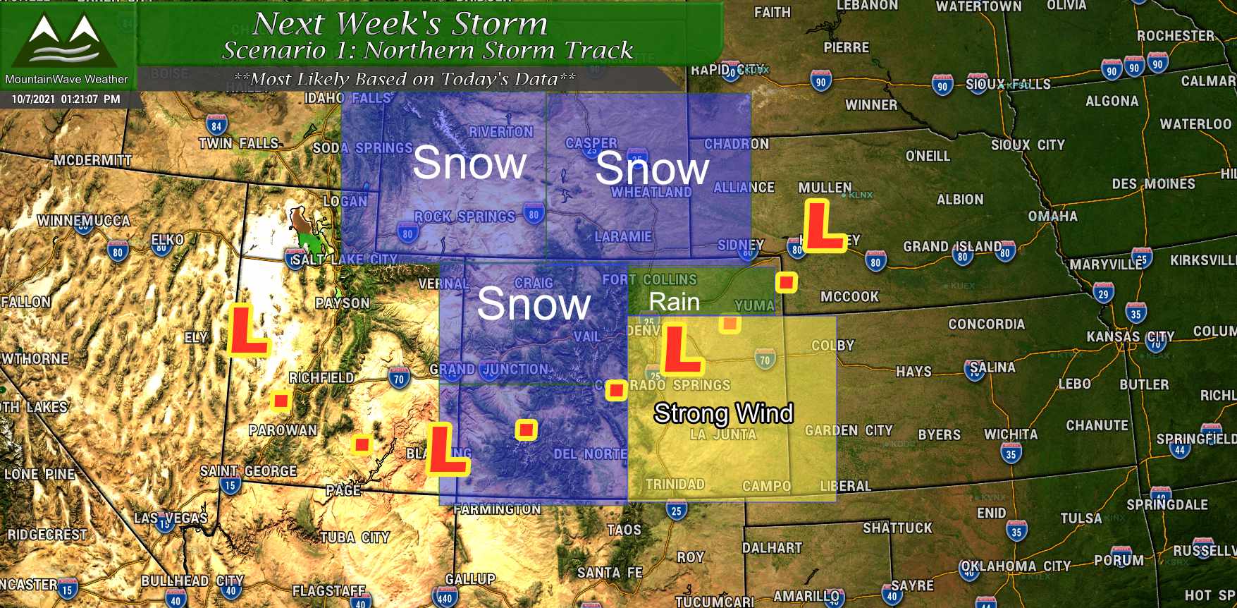
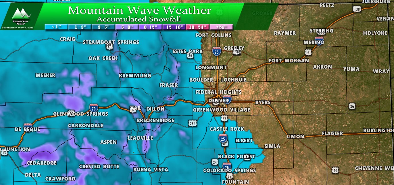
Here’s a quick graphic of what we would expect to see for certain areas of Colorado and Wyoming with a storm system in this scenario. Snow would be likely in the mountains and further North into Wyoming. Meanwhile, any precipitation along the front range would be limited by downslope off the mountains. Temperatures would be chilly, but most areas wouldn’t be cold enough to produce snow.
In this scenario – we overall would not expect much precipitation along Colorado’s front range but we would expect strong winds throughout the storm’s duration. If this situation were to verify, we would have to keep a close eye on potentially damaging winds.
Low moves ejects Further South and Moves Across Southern and Southeastern Colorado (Least likely scenario based on today’s data – this can still change!)
In scenario 2, the low tracks further South and moves across the mountains and into South and Southeastern Colorado while intensifying. This is a scenario where the front range and Palmer Divide could see snow. A further South low means colder air comes further South and more upslope can aid in moisture falling as snow. I want to make it clear though, a track like this is optimal for snow across the front range but does not guarantee that it will be a large snow producing storm. There are a ton of other variables that need to come into focus, we won’t have that data for a few more days.
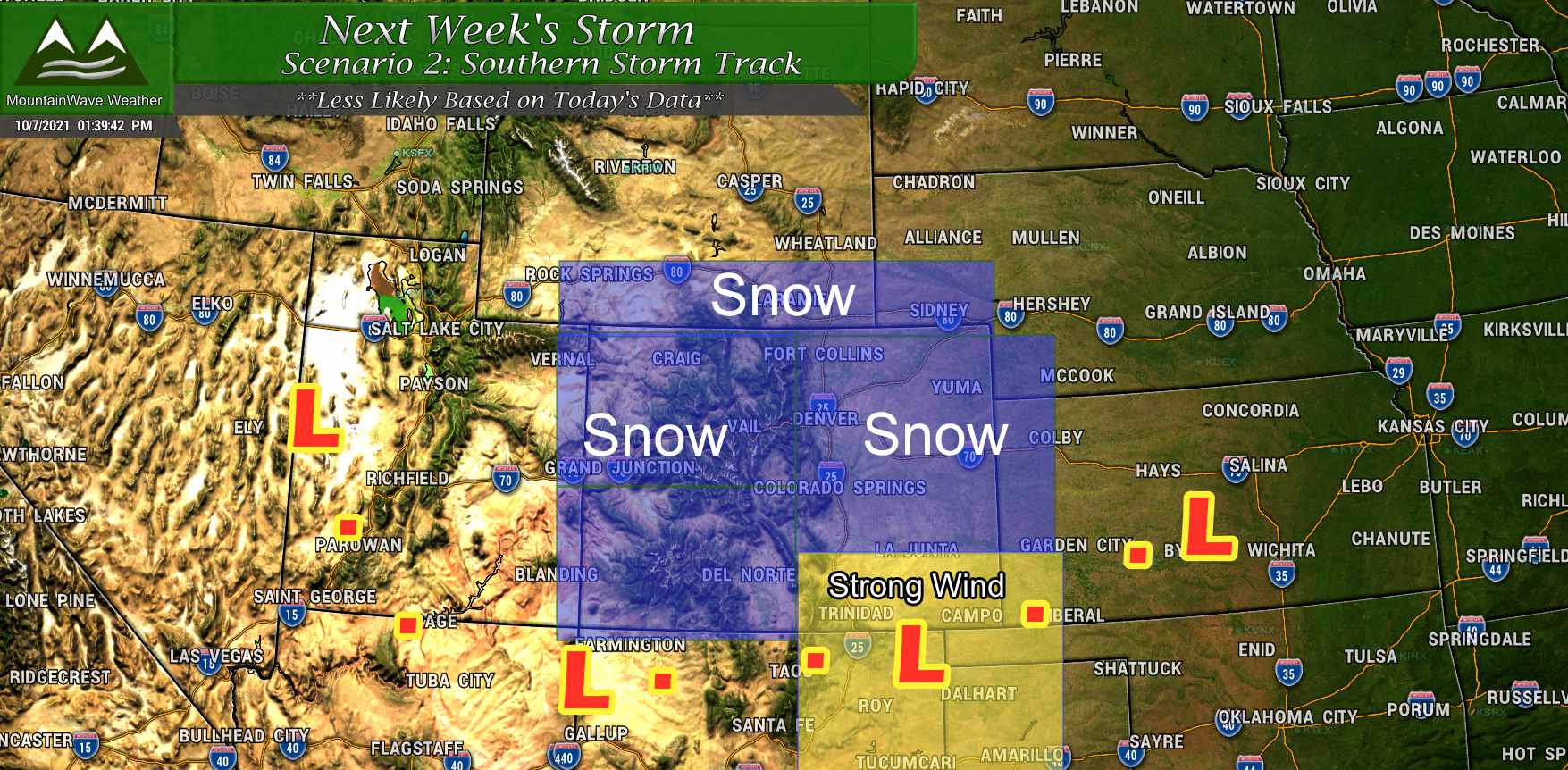
Most models are not showing this scenario as of today so it means that while it is still possible… it is less likely until we see better model agreement. If we begin to see more models shifting this thing South in the coming days, then we’d be a bit more confident on snow in and around the front range region.
What Do the Models Say?
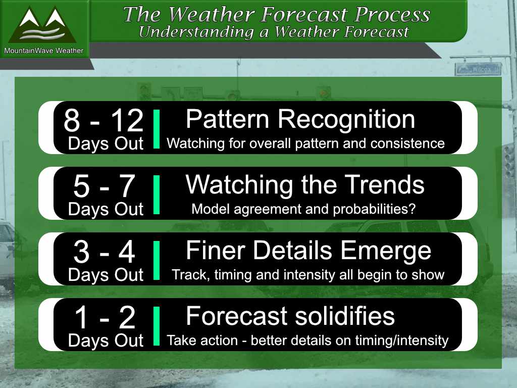
The only models I will show at this point in the forecast process are heights maps – these show areas of higher and lower pressure and winds. Anyone showing snowfall forecasts for the Tuesday/Wednesday timeframe at this point is doing you a disservice. Keep in mind, models are not a forecast – none of these images are saying what WILL happen… a weather forecast is fluid, especially this far out in time. Expect there to be changes and as such you can stay tuned here or to your favorite trustworthy weather source for further information.
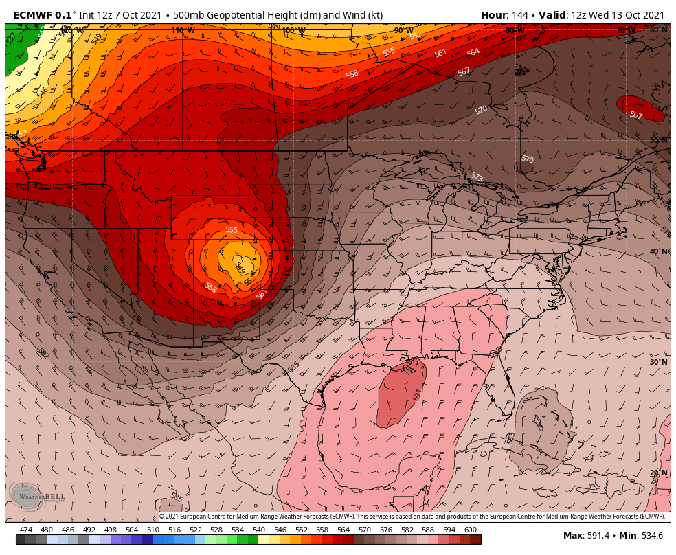
Euro Ensemble
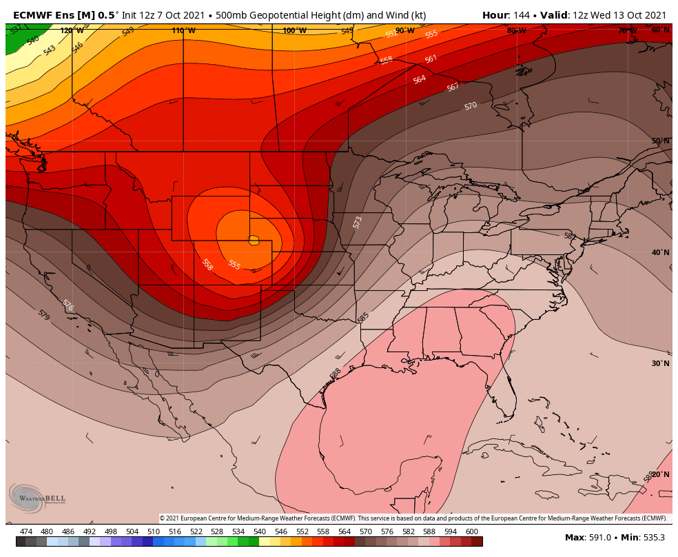
The Euro ensemble is a run and average of several different models presented on a map. It currently is trending towards Scenario 1 described above as it has the low reforming over Northeastern Colorado and into Wyoming. This would mean lots of wind for the front range but little precipitation. Colder temperatures would be likely too, but the further North this thing stays the less bite we will see with the cold.
Euro Deterministic
The Euro deterministic is just one model run. While it is leaning closer to scenario 1, notice the further South placement of the low. This doesn’t mean much now, but it will be something to keep an eye on to see if this model trends further South and the Ensembles follow suit. If so, we’d then have better confidence about precipitation possible in the form of snow along the front range.
GFS Ensemble
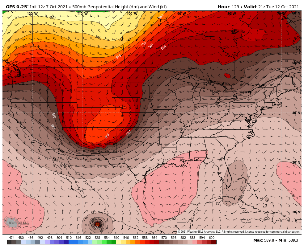
The GFS ensemble shows an interesting swing South to the storm system that lines up more with Scenario 2 as described above. If this were to verify, we would see more cold air, more precipitation and a better shot of accumulating snow along the front range. I’m not going to lie, the GFS has thrown out some very hefty snow totals for this storm along the Palmer Divide… the reason I don’t put much stock in it is because:
- The GFS tends to overestimate snow totals with many storms, especially further out in the forecast
- The GFS has trouble figuring out snowfall totals when you have borderline cold air (close to but not quite freezing)
Did I mention the GFS over-estimates snow totals???
The ensemble is meant to smooth some of the outliers out, but in this case the entire ensemble is trending much further South than the Euro. So while I don’t put much stock in this solution yet, it is something that will need to be watched.
GFS Deterministic

Like the ensemble, the deterministic for GFS trends the low further South. Not much different here to talk about than what I outlined above.
Key Messages
While we are far from the “preparation” phase of this forecast yet, there are a few things to plan for and keep a close eye on for this storm next week:
Freezing Conditions
- Somewhat likely for areas over 7,000 feet
- Possible for areas below
- We will have to keep an eye on temperature forecasts over the next few days
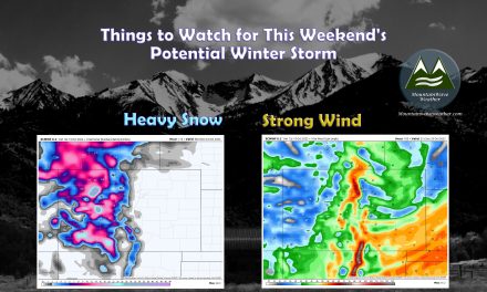
Strong Winds
- It is looking more and more likely that some areas may see strong to potentially damaging winds
- Regardless of the storm track, should it intensify across Eastern Colorado we would expect to see many areas experience strong winds
- Still fluid on these details as well – stay tuned for updates
Snow
- This is still the biggest question mark with this storm – mountain areas look likely to see some snow out of this but amounts are up in the air
- For lower elevations, snow will depend on storm track and temperatures – not enough data yet to make a call on those finer details
Agricultural/Ranching Interests
- Pay very close attention to the forecast, be ready to start making preparations for snow/strong wind/freezing temperatures by late in the weekend into next week
- Be ready to move animals in if necessary
- The growing season will likely end either this weekend or during this storm next week
Summary
We are still very much in the “wait and see” mode of this forecast so don’t get too worked up about anything just yet. All we can do is keep an eye on how things evolve over the next several days.
As always, if we get to the point where preparation/plan changes are required – I’ll make sure you know with plenty of time to take action.
Stay tuned and thanks for following along!
We are currently still in the “watching trends/wait and see” mode of this forecast as of today
