A bit of a busy update for this afternoon as there’s a lot going on in Colorado weather today and it will be a fairly active week as we continue this roller-coaster pattern we’ve seen so far in February. There’s a lot of dry conditions, strong wind and mountain snow in the forecast to kick off the week and we will transition into a much colder pattern as we progress through the week with more mountain snow, a bit more wind and maybe even a bit of snow down in the lower elevations if we are lucky.
There’s a lot to cover, so here’s the latest!
Colorado Weather Alerts
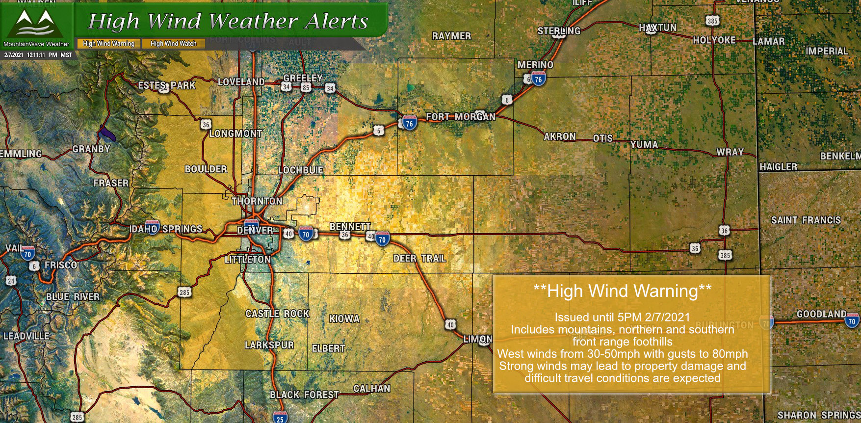
A High Wind Warning is in effect for the rest of today through 5PM. Strong winds in the mountains and foothills will make for difficult travel conditions as blowing snow and strong crosswinds will make for tricky conditions. If you are traveling to or from the mountains today, keep this in mind!
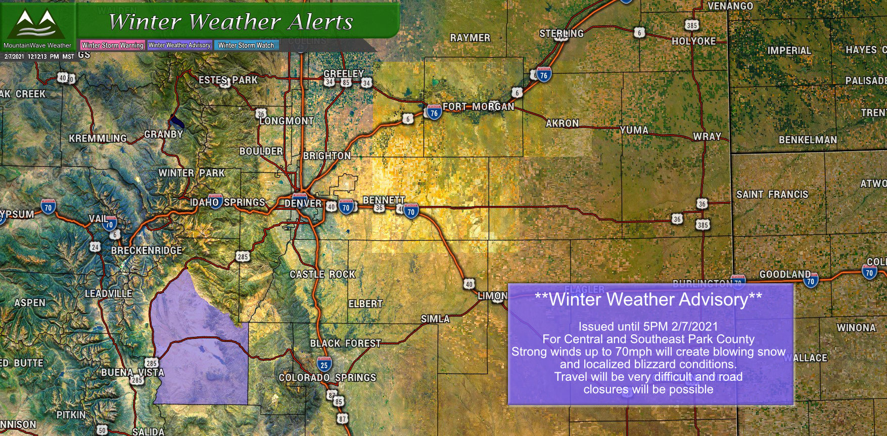
A small area in Park County has seen a Winter Weather Advisory issues as strong winds will combine with blowing snow to make for icy roads and blizzard conditions throughout the afternoon. The NWS specifically mentions Highway 285 and areas in and around Fairplay as possible trouble spots. As with the other warnings, be advised that travel will be difficult in these areas for the rest of today.
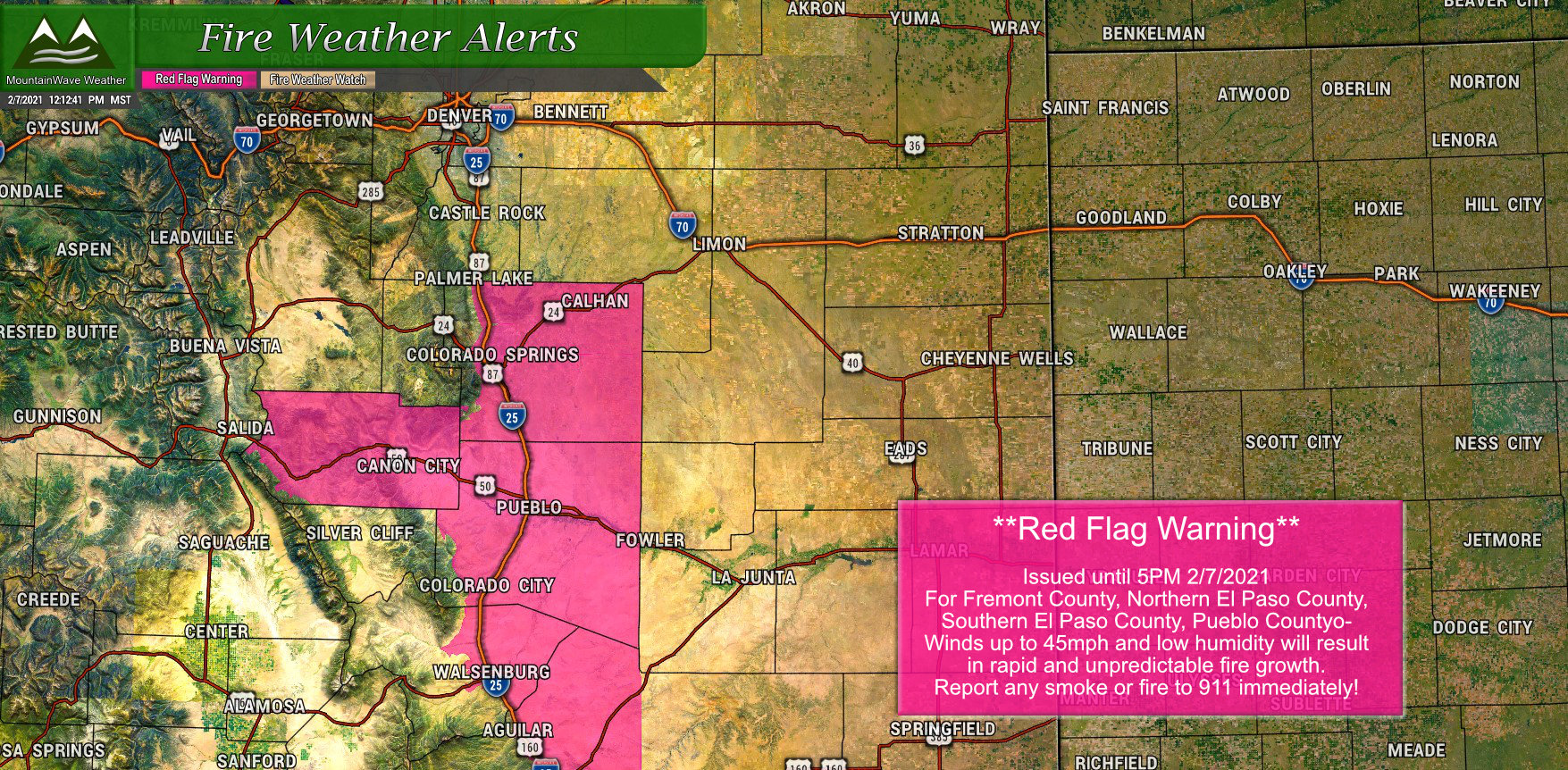
A Red Flag Warning has been issued for today (2/7/2021) through 5PM for strong winds and low humidity that will contribute to rapid and dangerous fire growth in these areas. The warning area includes most of the I-25 corridor South of the Palmer Divide and down through Pueblo, Walsenburg and the Colorado border. Travel may be a bit difficult for large profile vehicles in this region as well.
This Week – Mild Start then Arctic Air
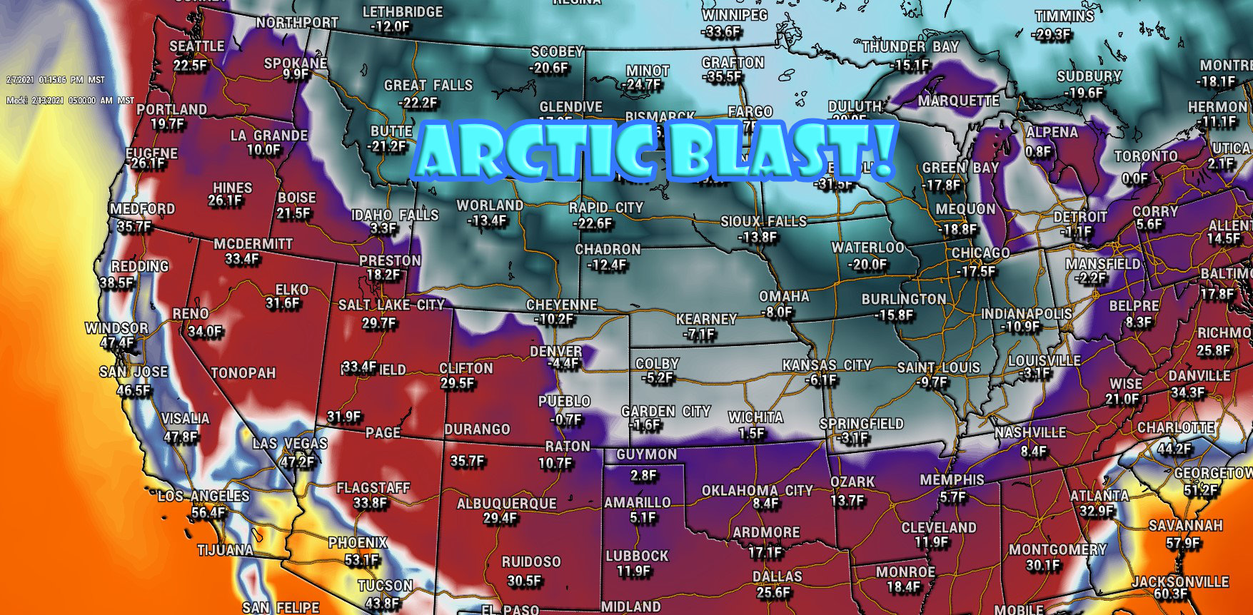
There is still a lot of flip-flopping back and forth on whether we will see any of the worst of the arctic air from Canada make its way into the front range and Palmer Divide regions. We were originally slated to see bitter cold temperatures by Monday but now it is looking less likely we see the cold air that early in the week. Most forecasts and models still show a decent amount of cold air later in the week.
The extended forecast for Castle Rock shown below illustrates the mild start followed by the bitter cold later in the week. The asterisk I’ll put here is that some models still show us getting colder earlier in the week than this forecast – but given that very few models are agreeing on anything we can safely say the confidence in any one solutions is low. For now we will go with this and make any adjustments as necessary.
Castle Rock Weekly Weather Outlook
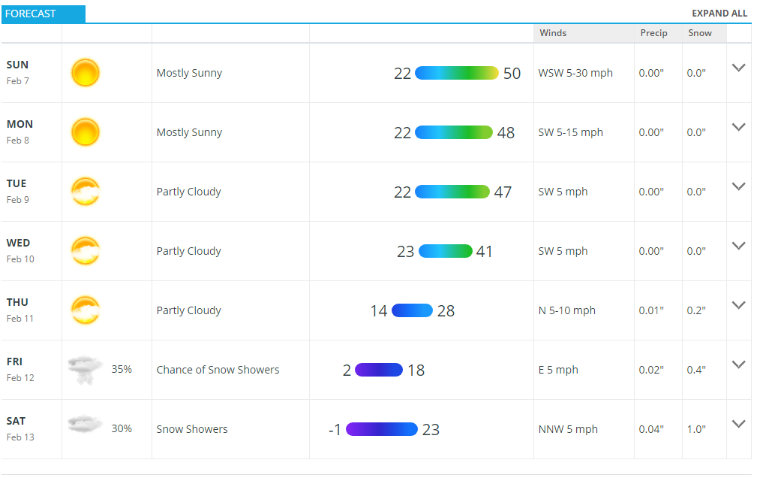
The other thing models don’t agree on too well is exactly how cold it may get later in the week. So take the above with a bit of a grain of salt and understand the forecast is still low confidence for later in the week – the numbers will change upwards or downwards a bit based on how confident we get on that cold air. Suffice to say though, it will end up somewhere between chilly and brutally cold.
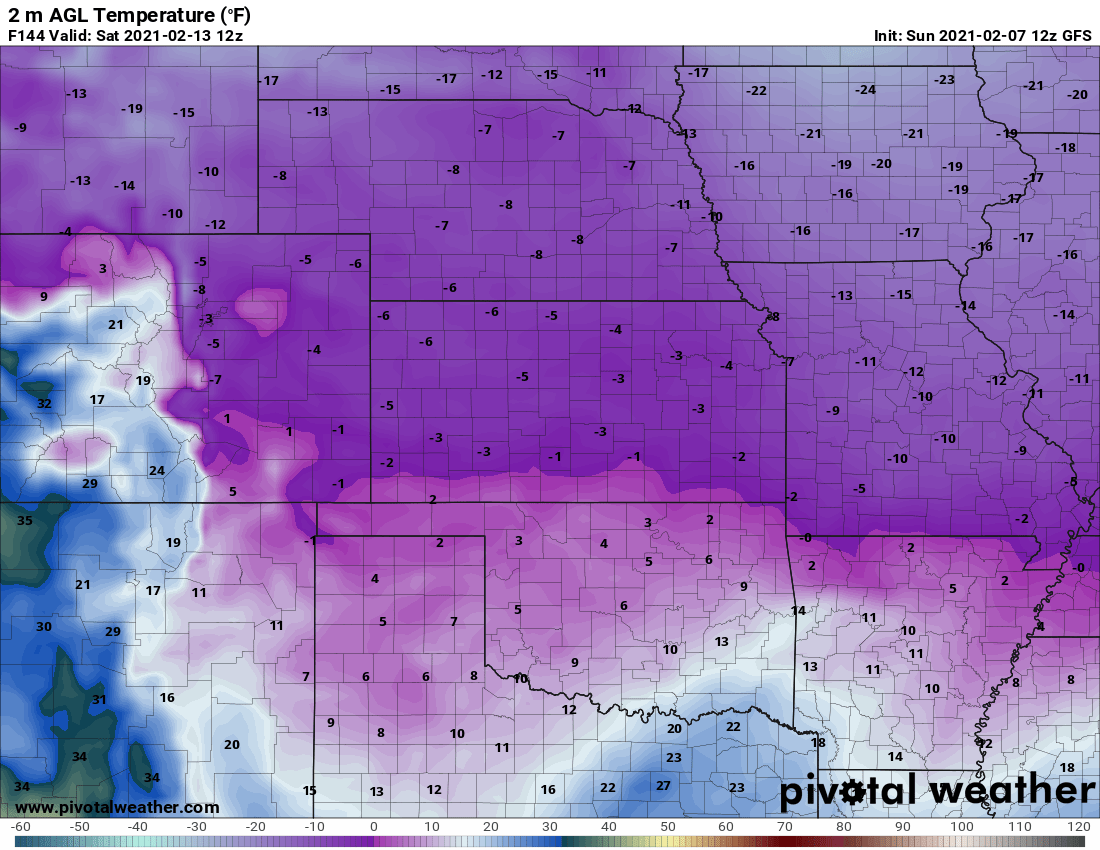
Just for fun, here’s what the GFS is thinking for low temperatures early Saturday morning. Remember, this is not a forecast, it’s just a model – but it does give you an idea of what is possible!
Any Snow?
As you can see from the extended forecast above, our next “decent” chance of snowfall looks to be late in the next week. Even with that bit of energy moving through, it doesn’t look all that exciting as our flow aloft looks to be Northwesterly – this is what we’ve seen with most storms this year and they are not a good setup for heavy snow East of the Divide.
With storm systems and this setup the only thing we can really hope for is a major shift in the track of these storm systems (unlikely) or we get lucky with another jet enhanced snowfall band that dumps a quick 4-8 inches somewhere. The problem with those is that they are fairly localized and there’s never a guarantee our area gets that band to set up and stay.
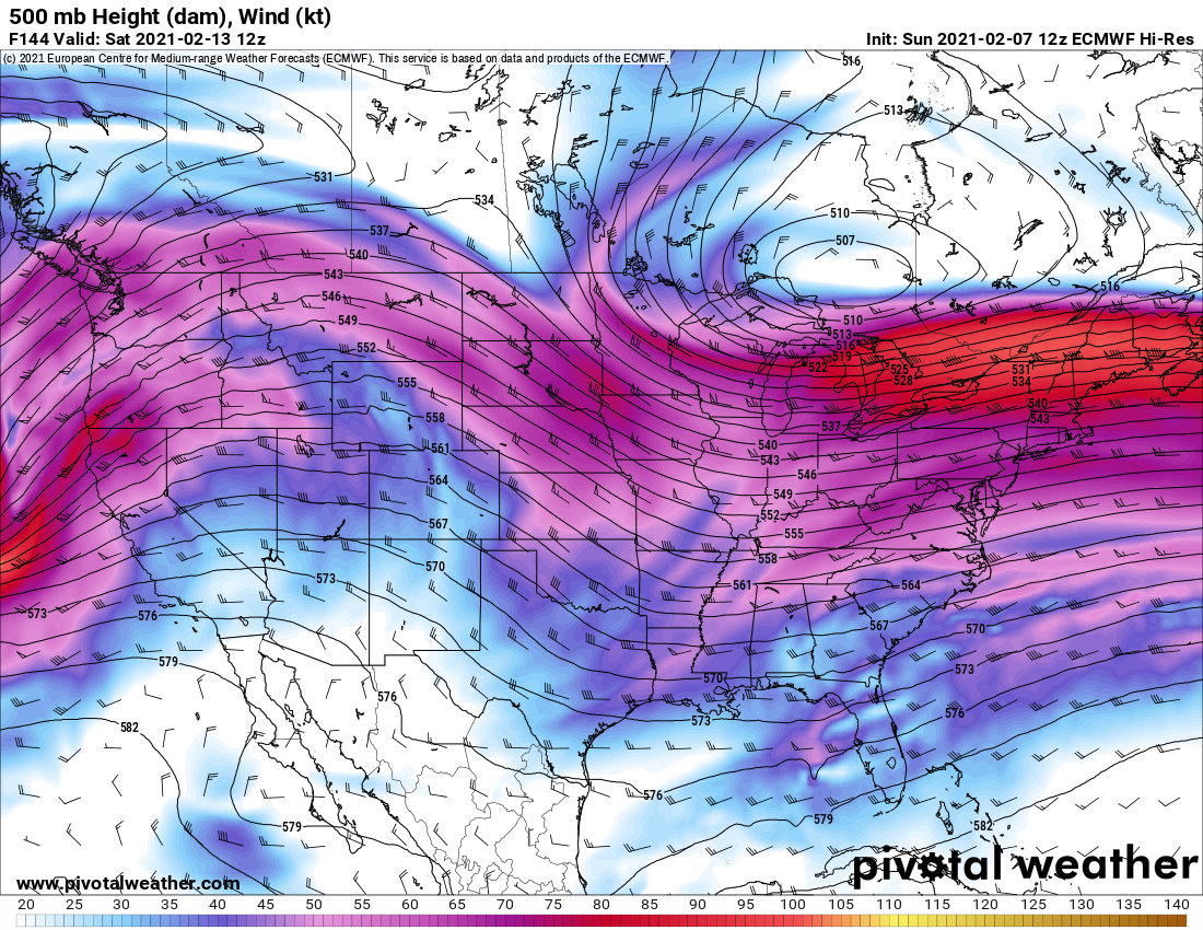
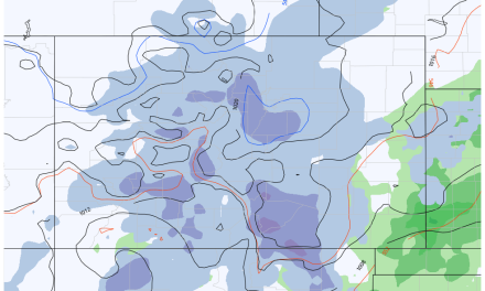
I’ll post a GFS model run for the next 7 days to give you an idea of what we are looking at.

Note: this is a model, not a forecast. Do not pay attention to precise snow numbers – instead just keep track of where this model sees a better chance of snow and where it keeps the storm track.
You all know how much I dislike posting snowfall model runs out this far (7 full days in this case) but I think sometimes it can be pertinent to show where a certain model keeps the storm track over a period of time. In this case, ignore the actual numbers completely as they will most likely change. Instead look at the overall pattern, the GFS keeps Northwesterly and Westerly flow which should be beneficial for our mountains… but you can see the holes of little to no snow over the Eastern half of Colorado.
As long we see this pattern in place, it is unlikely we see good chances for big snow storms along the front range or Palmer Divide.
Wrap-Up
More of the same for now I’m afraid in the snow department. We should still see these smaller storms rumble through here and there over the next 7-10 days and drop maybe enough snow to ice up the roads or cause some temporary travel headaches but it’s unlikely we see anything larger during that time.
As far as the cold, there’s still a lot of uncertainty around that but this one of those “better safe than sorry” scenarios. If you have outdoor plans or if you deal in the agricultural or ranching world be sure to keep a close eye on the forecast and have all cold weather preparations completed by Wednesday.
