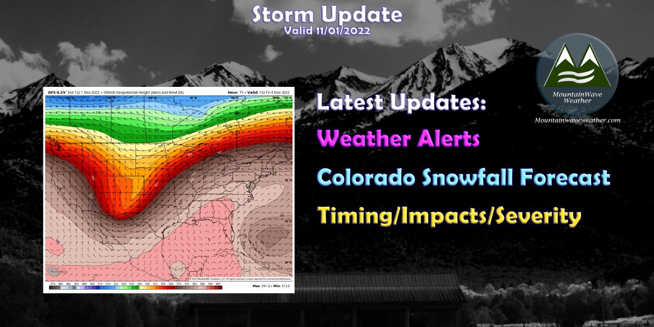
Colorado’s Next Storm Moving in Later This Week
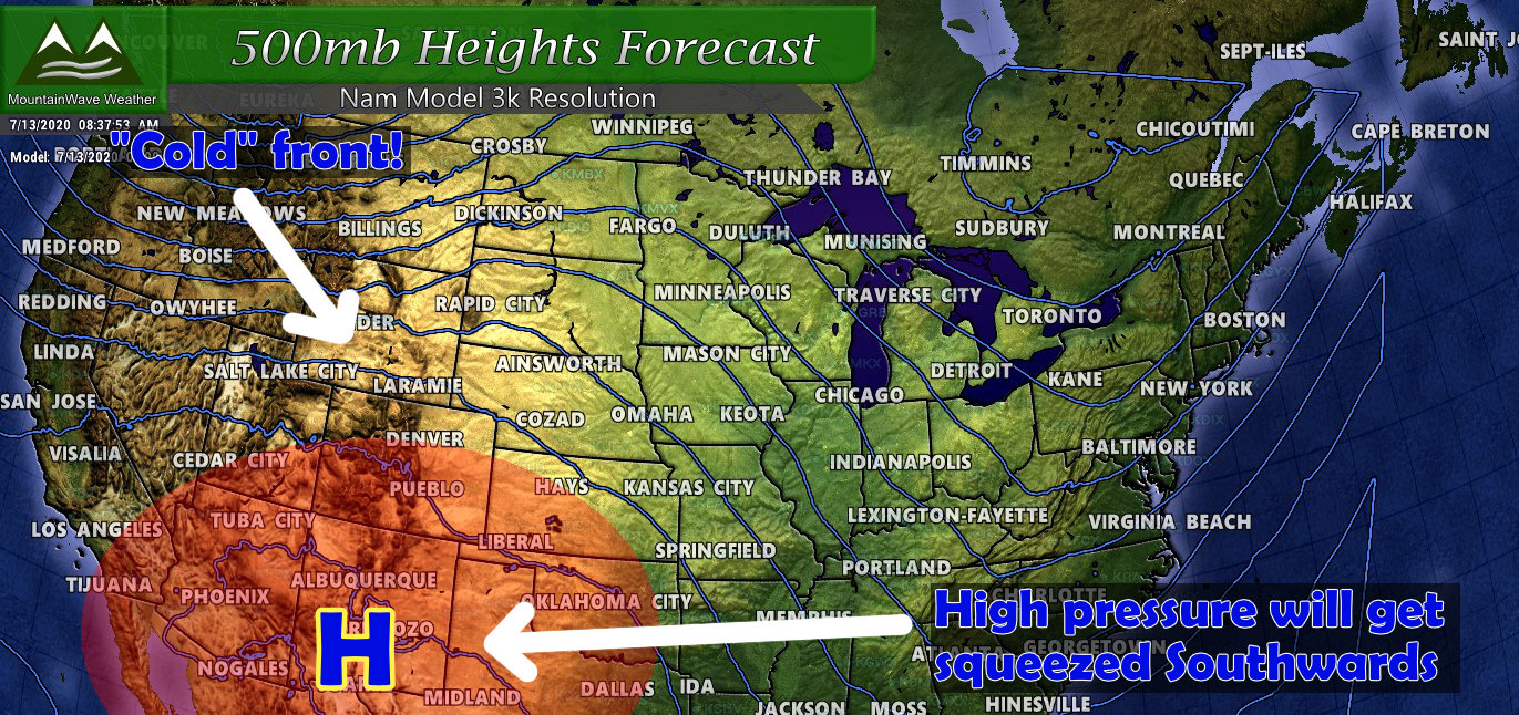
As our somewhat active weather pattern continues across the Western U.S. we are tracking the next storm system to move through Colorado on late Wednesday and into Thursday and Friday. While it doesn’t look major for much of the Eastern part of the state – the mountains may see heavier snow, higher snowfall accumulation and possibly travel impacts. Here’s the latest details:
Colorado – Statewide Weather Alerts
As is typical with these types of storms, the type of alert depends on your location. Fire weather watches and warnings are in place across the plains while the mountains have Winter Weather Advisories for difficult travel and Winter Storm Warnings for dangerous travel. Here’s the details:
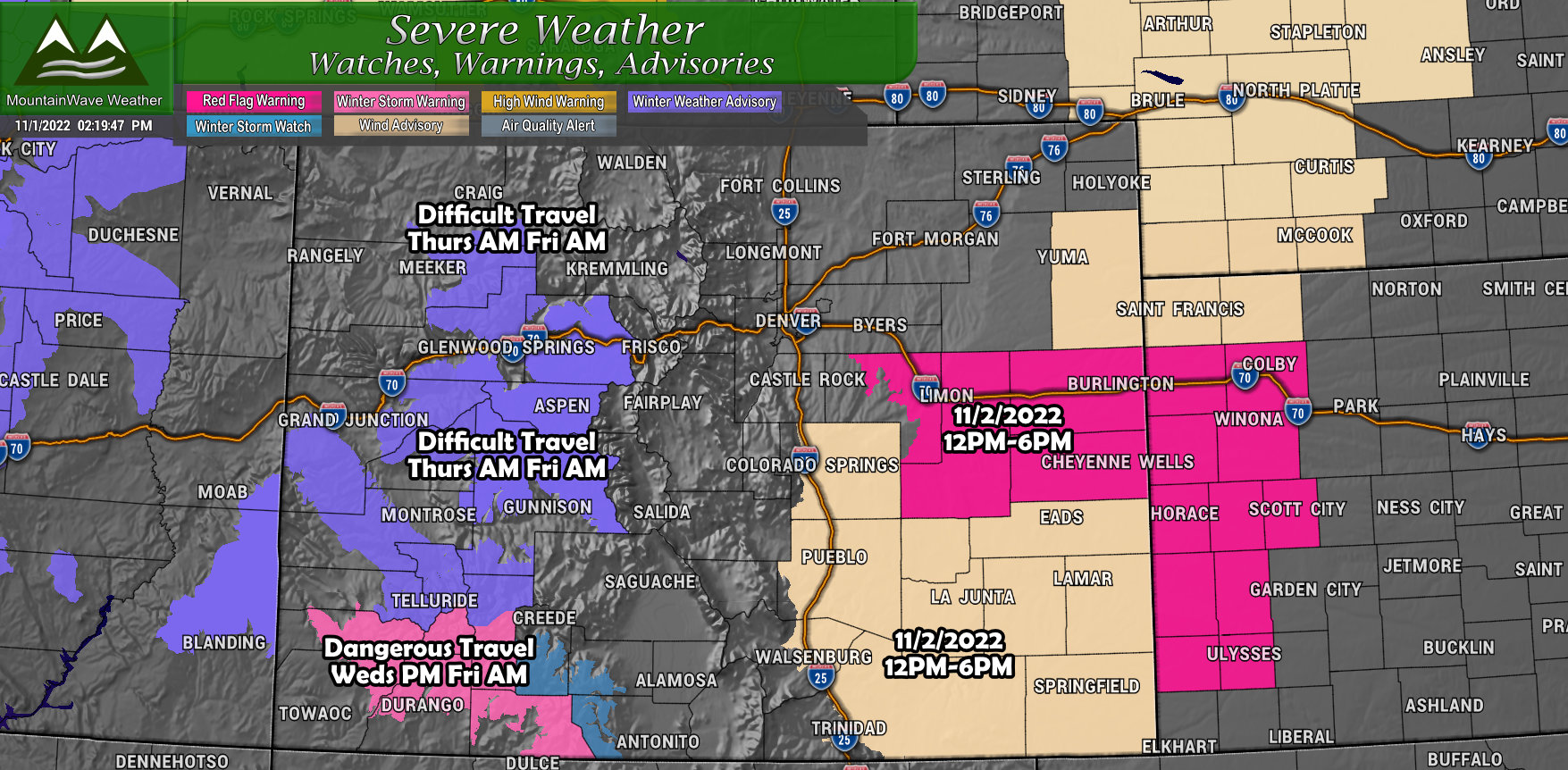
Red Flag Warning
IN EFFECT FROM NOON TO 6 PM MDT WEDNESDAY FOR
WIND AND LOW RELATIVE HUMIDITY FOR LINCOLN AND EASTERN ELBERT
COUNTIES
The National Weather Service in Denver has issued a Red Flag
Warning for wind and low relative humidity, which is in effect
from noon to 6 PM MDT Wednesday.
* Timing…Wednesday from noon to 6 pm MDT.
* Winds…Southwest 15 to 20 mph with gusts up to 30 mph.
* Relative Humidity…As low as 13 percent.
* Impacts…Above normal temperatures, low relative humidity,
and breezy conditions could lead to rapid fire spread for
ready to burn fuels. Avoid any burning or outdoor activities
that may produce a spark and start a wildfire.
Fire Weather Watch
FIRE WEATHER WATCH IN EFFECT WEDNESDAY AFTERNOON FOR GUSTY
WINDS AND LOW RELATIVE HUMIDITY (See graphic for locations)
The National Weather Service in Pueblo has issued a Fire Weather
Watch for gusty winds and low relative humidity, which is in
effect Wednesday afternoon.
* Winds…Southwest 15 to 20 mph with gusts up to 35 mph.
* Relative Humidity…As low as 13 percent.
Winter Weather Advisory
IN EFFECT FROM MIDNIGHT WEDNESDAY
NIGHT TO 6 AM MDT FRIDAY…
* WHAT…Snow expected. Total snow accumulations of 6 to 12
inches. Winds gusting as high as 35 mph.
* WHERE…Elkhead and Park Mountains, Gore and Elk
Mountains/Central Mountain Valleys, West Elk and Sawatch
Mountains and Northwest San Juan Mountains.
* WHEN…From midnight Wednesday night to 6 AM MDT Friday.
* IMPACTS…Plan on slippery road conditions. Patchy blowing
snow could significantly reduce visibility. A detailed map of
the snowfall can be found at: www.weather.gov/gjt/winter.
Winter Storm Warning
IN EFFECT FROM 6 PM WEDNESDAY TO MIDNIGHT
MDT THURSDAY NIGHT…
* WHAT…Heavy snow expected. Total snow accumulations of 12 to 20
inches. Winds gusting as high as 45 mph.
* WHERE…Southwest San Juan Mountains.
* WHEN…From 6 PM Wednesday to midnight MDT Thursday night.
* IMPACTS…Travel could be very difficult. Patchy blowing snow
could significantly reduce visibility. A detailed map of the
snowfall can be found at: www.weather.gov/gjt/winter.
Winter Storm Watch
IN EFFECT FROM WEDNESDAY EVENING THROUGH
FRIDAY MORNING…
* WHAT…Heavy snow possible. Total snow accumulations of 8 to
24 inches possible. Winds could gust as high as 40 mph.
* WHERE…Eastern San Juan Mountains Above 10000 Feet.
* WHEN…From Wednesday evening through Friday morning.
* IMPACTS…Travel could be very difficult to impossible. Patchy
blowing snow could significantly reduce visibility. The
hazardous conditions could impact the morning or evening
commute.
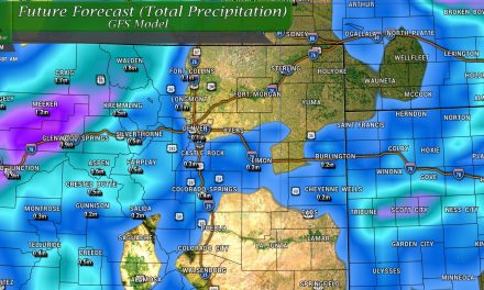
Snowfall Forecast
Snowfall forecasts are fluid and can change based on storm track, intensity and timing. Be sure to stay tuned for any updates!
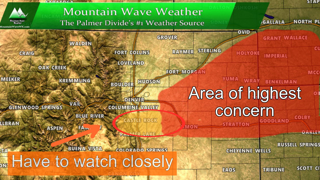
Palmer Divide
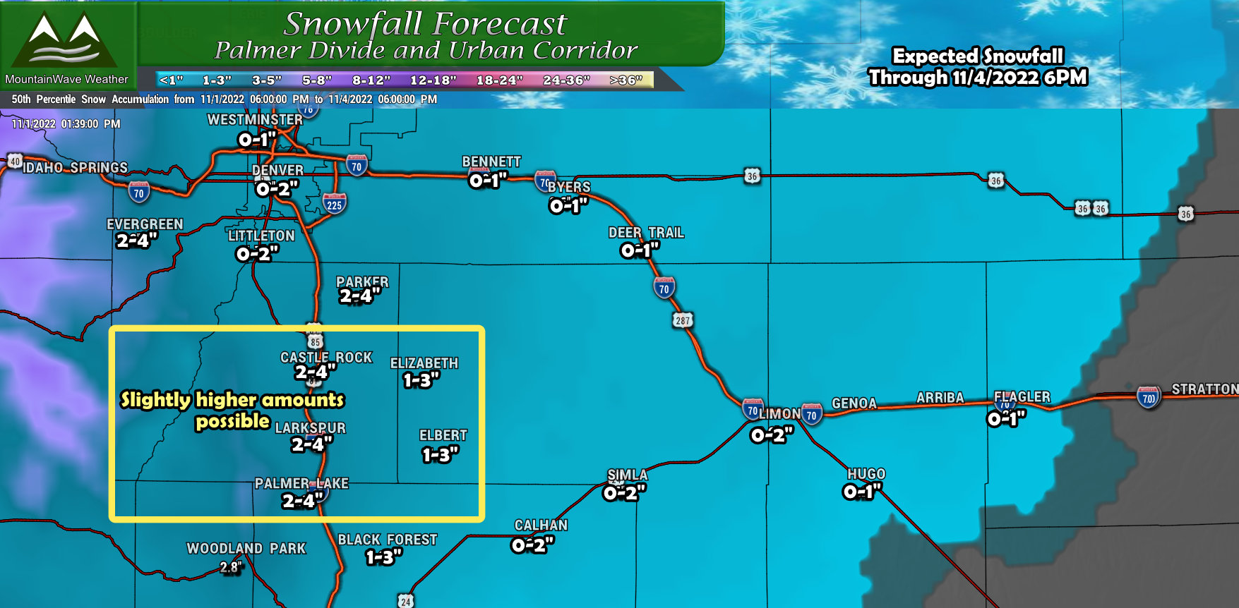
A similar setup to the last storm along the Palmer Divide. Temperatures will play a role so higher elevations of the Palmer Divide will see more snow than lower elevations towards Denver. We’ve accounted for that in the forecast and outlined an area to watch (just like the last storm) for boom potential for snowfall accumulation. While this won’t be a major storm with large snow totals, a few select places may see an inch or two above our forecasted range outlined above.
Northern Colorado
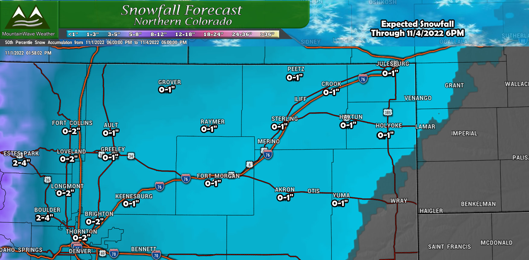
A bit more widespread snow accumulation possible for Northern Colorado. Just like the past storm, the best chance for a bit higher snow totals will be in the foothills West of I-25. While snow accumulation looks a bit more widespread, the totals in this region won’t be much to write home about.
Southern Colorado
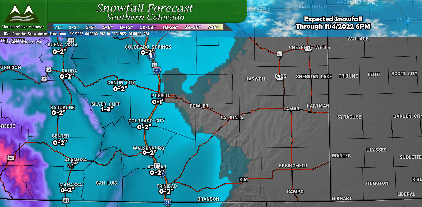
Snowfall will not be favorable for this region with the current track of the storm. Many areas along and West of I-25 may eek out an inch or two of snow, but like Northern Colorado – the amounts won’t be much to talk about in the areas around Southern and especially Southeastern Colorado.
Northwestern Colorado
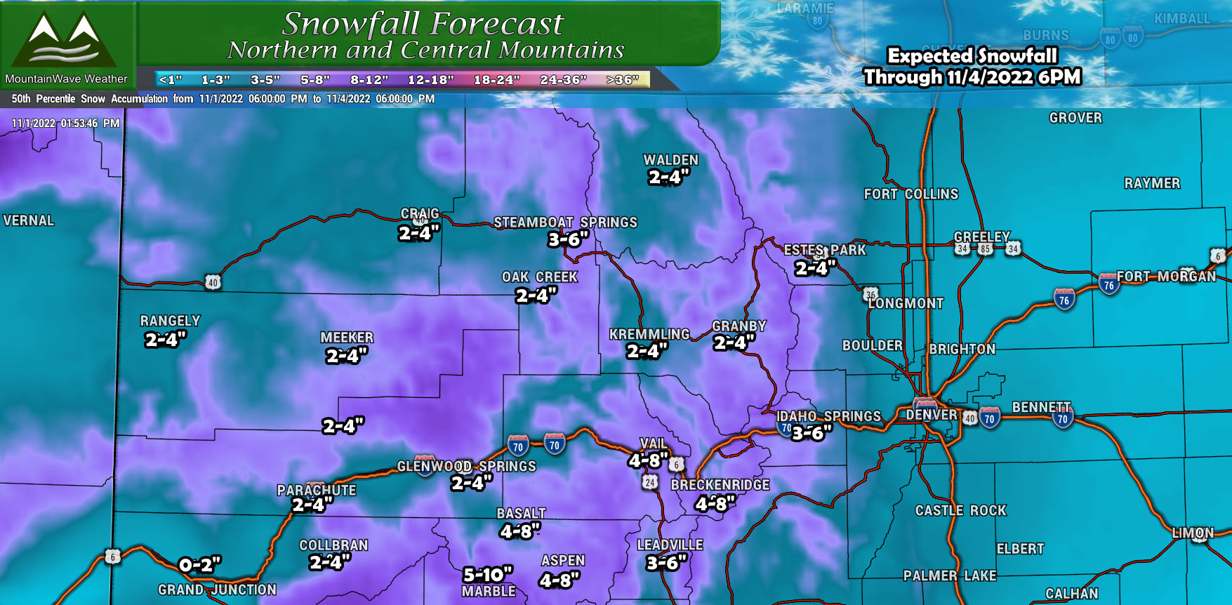
The Northern and Central mountains could do well with this storm, many favored areas facing to the West will see decent amounts of snow. Again, the higher peaks and elevations stand the best chance here while the lower mountain valleys will see snow, but lesser amounts. Keep an eye out for travel impacts in these regions especially on Thursday.
Southwestern Colorado
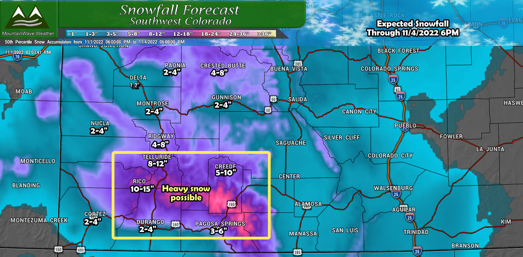 Just like the Northern and Central Mountains, some areas of the Southwestern Mountains will be favored for snowfall with this storm. Aras around Pagosa Springs, North of Durango, Creede, Telluride and surrounding areas could see heavy snow with significant amounts in some areas. This region looks most likely to have severe travel impacts during this storm on Thursday.
When to Watch for Impacts
While finer details on impacts are still up in the air – at this time it looks like impacts will be in the limited category. As always, these can change based on new forecast data, be sure to keep checking back for any changes.
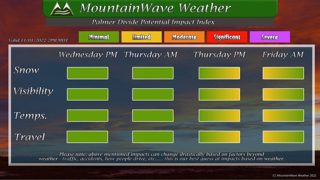
As of right now, the Palmer Divide looks to see impacts manifest late in the day Thursday through early morning Friday. This means that if we see any impacts related to travel or snowfall, Thursday evening into Friday morning would be the most likely times those would occur with the data we have right now.
This timing may wobble a bit, but for now – keep an eye on that window if you have travel or plans along the Palmer Divide and be sure to pay close attention to the forecast.
Summary
More weather to deal with and hopefully we get a bit of moisture out of this storm… it is getting quite dry around here.
As always, I’ll have more updates as needed – for reference; lots of updates means forecast is changing, few updates mean forecast is on track or very few changes.
Stay tuned!
