The Tricky Part – Storm Setup
You’ll imagine my surprise when looking at weather data this afternoon and finding the Euro had shifted our upper level low into this position as of this afternoon. This is actually close to a very favorable position for front range snowfall. As exciting as that sounds, the other models don’t’ agree and there’s a couple of other things working against us here…
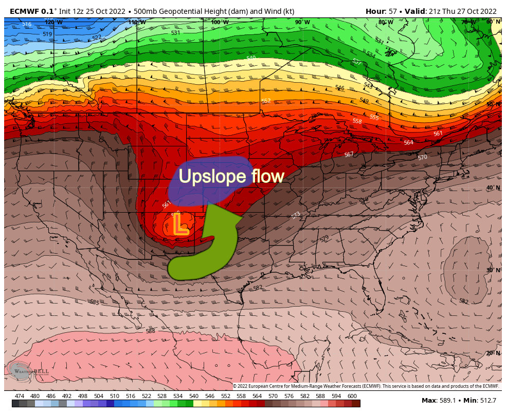
- The other models don’t agree with positioning
- The low is a smidge too far South to be in the “prefect” position
- Most models show the low weakening as it moves Eastward – meaning a stronger snowstorm will be more difficult to form and sustain
Still, this has me intrigued and I’ll have to keep a close eye on it over the next few days. As of right now, the Euro has higher snowfall totals along the Palmer Divide than I’m forecasting – but right now it is an outlier. We will have to see over a few more model runs on whether this one backs off and joins the other models, or they all start trending towards the Euro solution.
Either way, it should be fun to watch. Here’s the forecast with the latest data but keep in mind this is all subject to change based on new data coming in. For now, it should give you enough of a heads up on roughly when to expect this all to kick off. We will continue to work on finer details around timing and impacts.
Snowfall Forecast
These totals are for roughly 72 hours which runs through 6PM Friday. Most of the snow will be done by Friday morning, but the mountains may see a few lingering snow showers. Make sure you remember this, don’t ask where the snow is or claim a busted forecast on Wednesday or Thursday morning (you’d be surprised how much that happens!)
Palmer Divide/Denver Urban Corridor
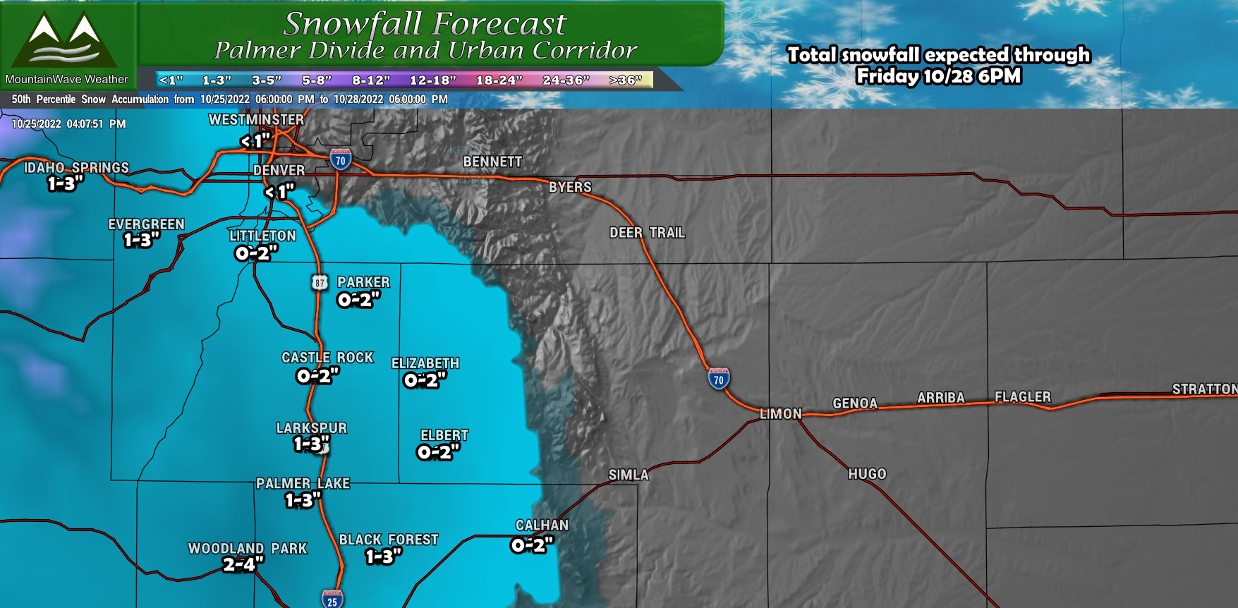
The higher elevations of the Palmer Divide stand to have a bit better shot at accumulating snow from this storm, but it still wont’ be much to write home about. Models are in pretty good agreement that most of the divide sees snow in the 0-2″ range with some select higher locations seeing 1-3″ or even 2-4″ but that will be the exception rather than the rule. As you travel further West towards the foothills, you may see slightly more snow accumulate as well.
Northwestern Colorado
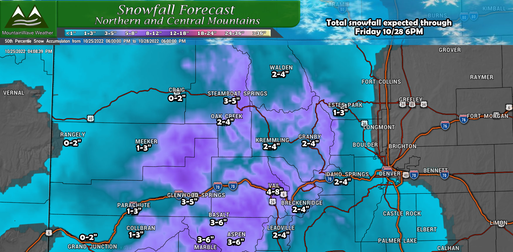
The Northern and Central mountains will actually see several periods of snow starting tonight (Tuesday night) and lasting on and off through Friday morning. Any snow is welcome in these areas, but much like the last storm – how much you receive will largely depend on where you are. It won’t be a widespread high snow accumulation event but some areas could see totals end up in the 3-6″ or even 4-8″ range… most areas will see lighter totals overall however. Refer to the map above for more details on where those might be.
Southwestern Colorado
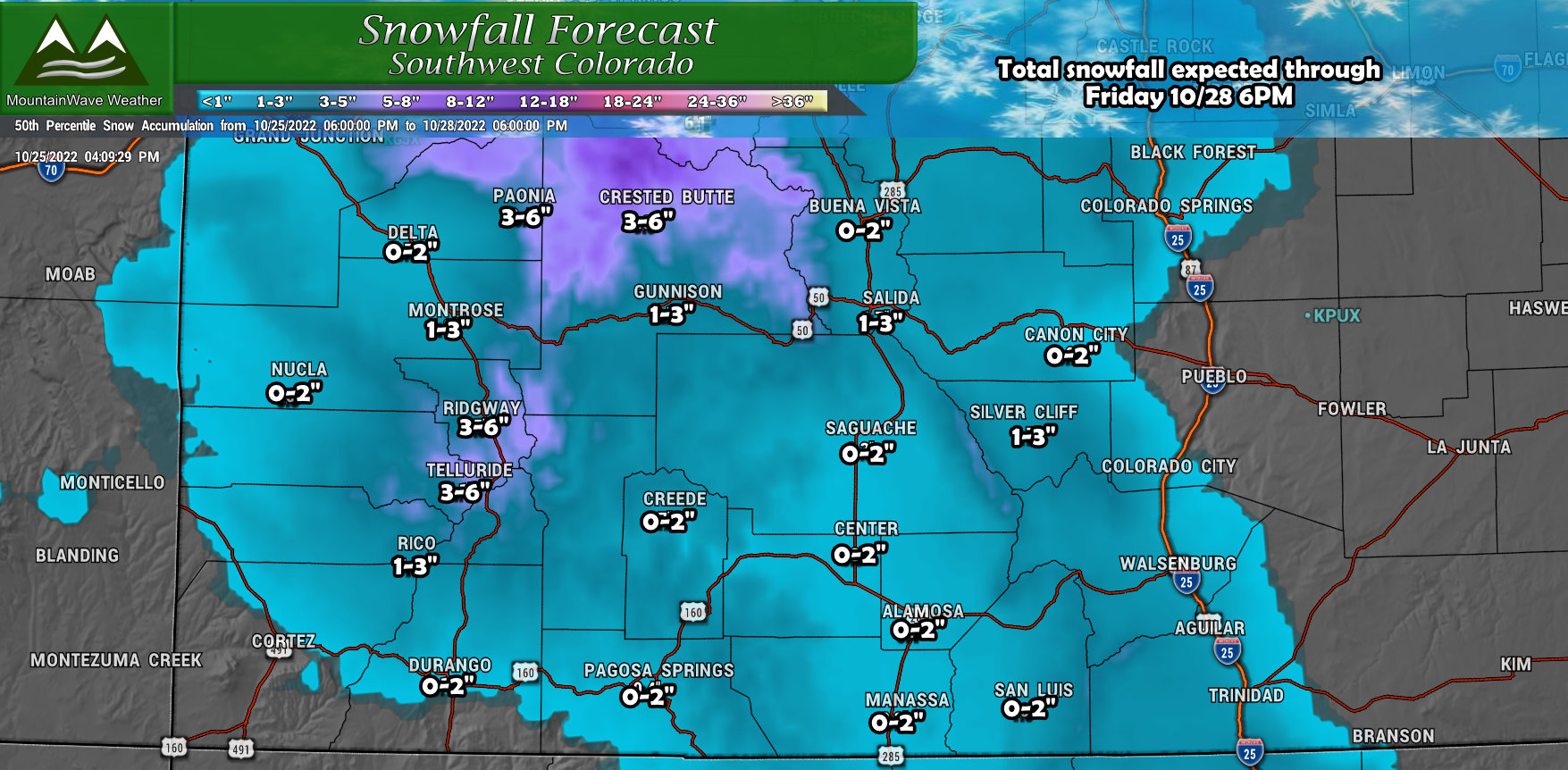
Due to the track of this storm, it won’t be much of a dump for the Southern Mountains, the low pressure system will move right over some of these areas in Southern Colorado which is not favorable for them. Largely expect totals to be in the 0-2″ or 1-3″ range with a few exceptions in the higher elevations to the North. Northward and Northwestward facing peaks will be favored here.
Timing and Impacts
Here’s a look and re-introduction to our handy-dandy impact index graphic. I put this up for a lot of snow storms to help illustrate what times you should be watching out for and what the anticipated impact (headache factor) will be. The higher the impact factor, the more issues you will have if you get caught out and about in a specific storm.
For this storm, impacts overall look pretty light across the Palmer Divide.
One word of caution with this graphic; you have to keep an eye on the forecast and keep checking back for changes. As the forecast evolves, so does this graphic – I try to update it as much as possible so everyone has a solid heads up!
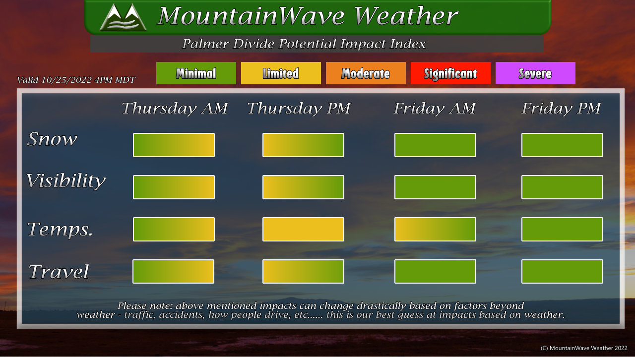 Thursday is the primary action day with this storm, although models still disagree a bit on exact timing the snow starts and how long it sticks around – they all agree that the snow flies on Thursday at some point. So keep an eye out later Thursday morning and into the afternoon…
By evening, the storm should move out leaving slick conditions in some areas but a lot of the roadways should recover later into the evening and into Friday.
