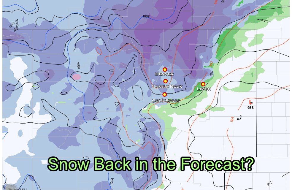
Big Storm System Expected Next Week
Models have been picking up on a large storm system scheduled to move through the Western and Central U.S. next week. A lot of media has been picking up on this and the hype machine is beginning to spin. Let’s take a bit more of a “grounded” approach with this storm and discuss why this thing is no sure lock for anything as of yet.
Models – Can’t Come to Agreement on this Storm So Far
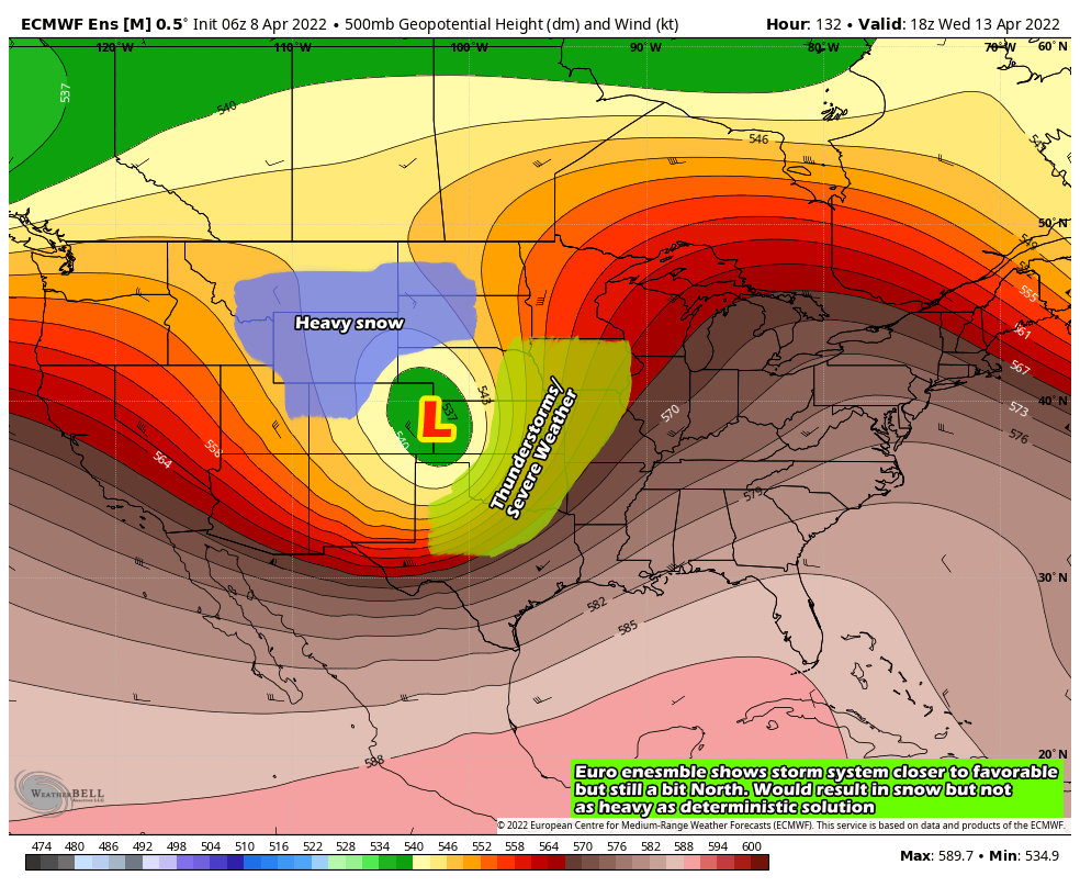
European Model Ensembles
We will start with the Euro ensembles, which shows the center of the storm system rapidly intensifying over Eastern Colorado. In this scenario, Colorado’s mountains would see heavy snow and the plains would see significant snow as well. This combined with strong winds means that we could see blizzard conditions in some parts of Eastern Colorado. This product still has the low a bit too far North than I would like to see for a major impact along the front range, but it has been trending Southward over the past several runs.
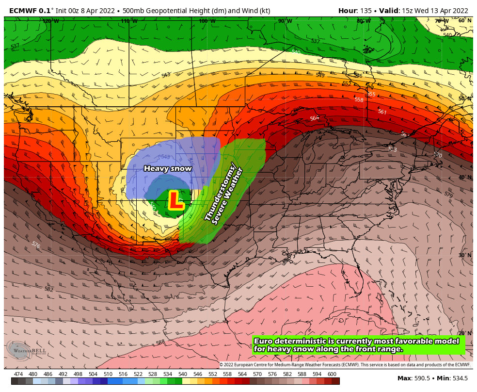
 European Deterministic
If you’re a late season snow lover, this is the model you want to root for. The Euro deterministic brings the low up and across Southern and Southeastern Colorado with rapid intensification out onto the plains. In this scenario we would see strong winds and a ton of moisture. If the temperatures play ball (and this model suggests they will) you could see significant snowfall accumulation and possible blizzard conditions in Eastern Colorado. Is this model an outlier right now? Yes it is, the ensemble suite above is better at ironing out those types of outliers but it has been trending more in line with this solution over time.
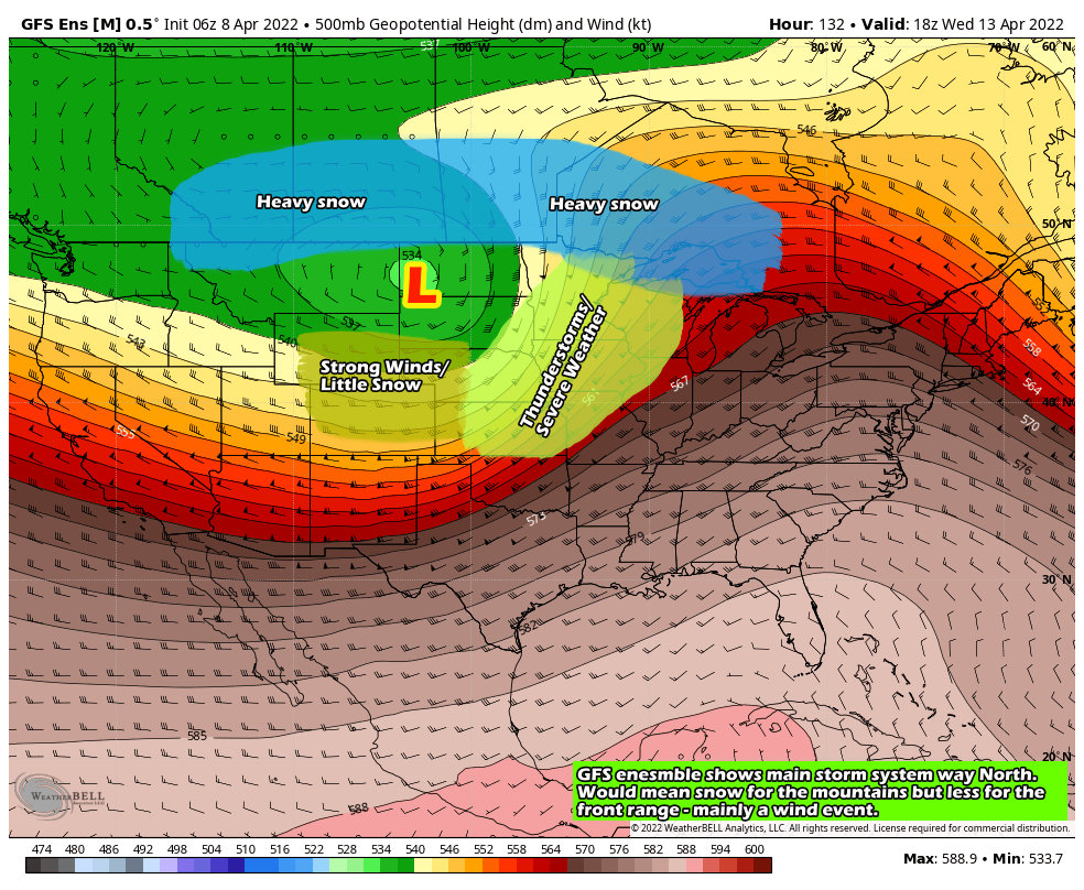
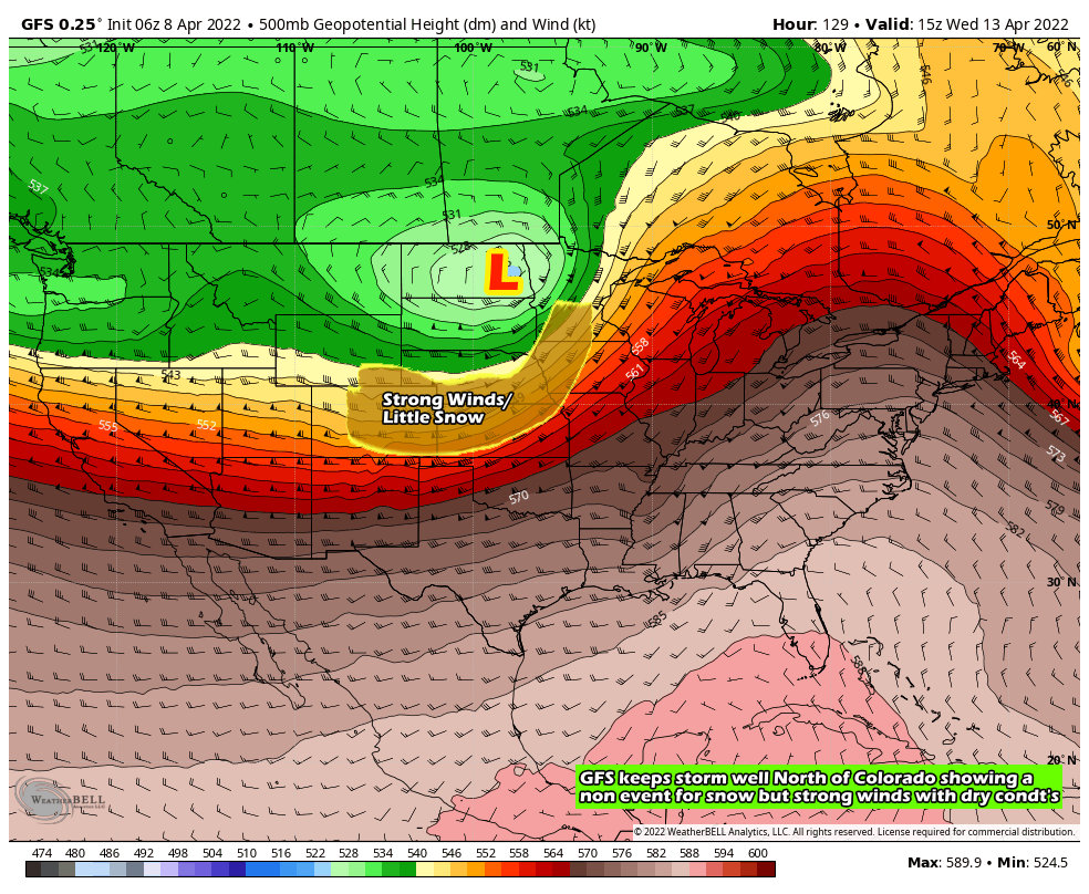
GFS Model Ensembles
The GFS is so completely different from the Euro at this point it’s almost laughable. In this scenario the low stays well North of Colorado meaning the heaviest snow would likely up into the extreme Northern parts of the U.S. and into Canada. Severe thunderstorms would be possible in the warm sector in front of the storm but the threat would be further North than the Euro is showing. For Colorado, our mountains would still see snow out of this but since the flow is Westerly it is likely the plains of Colorado including Denver would see a high/damaging wind event out of this with very little moisture at all.
GFS Deterministic
Much like it’s ensemble mean above, the deterministic version of the GFS has the storm system well to the North of Colorado. This would result in a similar setup where Colorado’s mountains see the bulk of any moisture while those of us on the plains get stuck with strong winds and dryer conditions.
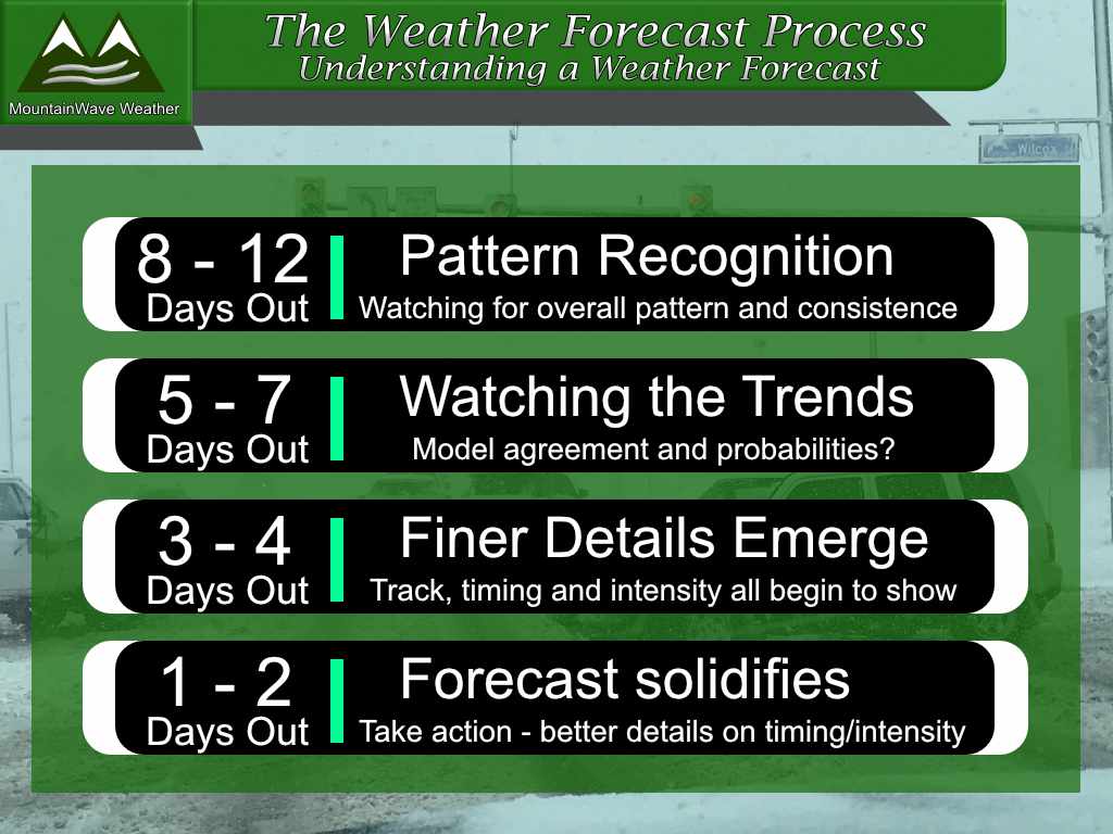
What We Know
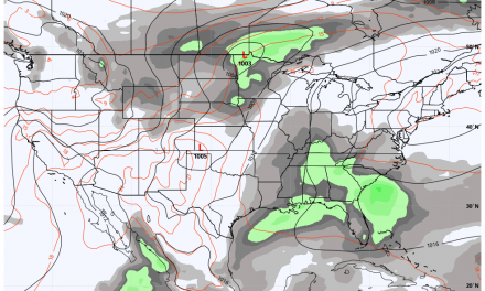
I like to throw this graphic up to remind everyone where we are in the forecast process at this point with this storm system. Being this storm arrives Tuesday/Wednesday next week we are still in the “Watching the Trends” phase. This means we are looking at models to see if we start to see any agreement – at this point there is very little agreement which means anything we speculate on at this point is low confidence at best.
I mention this because when the weather community gets all excited about storms like this you often start to see a lot of “hype” thrown around predicting huge storms or huge impacts without much data to support who, where and when will see the worst impacts. Beware of Hype!
Now that’s out of the way, here’s what we know or have higher confidence in:
- In nearly all model scenarios, Colorado’s mountains receive decent amounts of snow next week. This gives us higher confidence in that.
- In nearly all model scenarios, severe weather occurs in the warm sector East and Southeast of the low. Higher confidence that folks in the middle of the country see severe weather in advance with this storm next week – we will just have to nail down where in the coming days.
- A majority of models show at least a moderate to high end wind event possible with this storm for the front range of Colorado.
- Nearly all models have this as a major storm, the GFS slightly less so but the Euro and Euro Ensembles have a very strong, potent, closed low moving across the region. We have higher confidence this will be a rather large storm with potentially large impacts – for someone…
What We Don’t Know – Lower Confidence
- The wildcard for Eastern Colorado is really a coin flip. In nearly all models one of the two scenarios occurs: we get hit with strong and damaging winds with little moisture OR we get hammered with snow… measured in feet. Both of those scenarios are equally likely at this point, we won’t know which scenario looks more likely until we start to see better model agreement. That may be a couple of more days. Keep in mind though, while these are the two most likely scenarios now, things can still change so we will have to keep an eye on that.
- Location for severe weather; in front of this storm we will probably see some type of severe weather outbreak. If the storm tracks further North per the GFS, we would expect to see that severe weather further North, while with the Euro we would see it further South. For what it’s worth, the folks at the Storm Prediction Center have day 4-6 outlooks for severe weather further South which means they are leaning towards the Euro or some blend… I would too.
- Major storm with major impacts, who sees what and where? (as mentioned above)
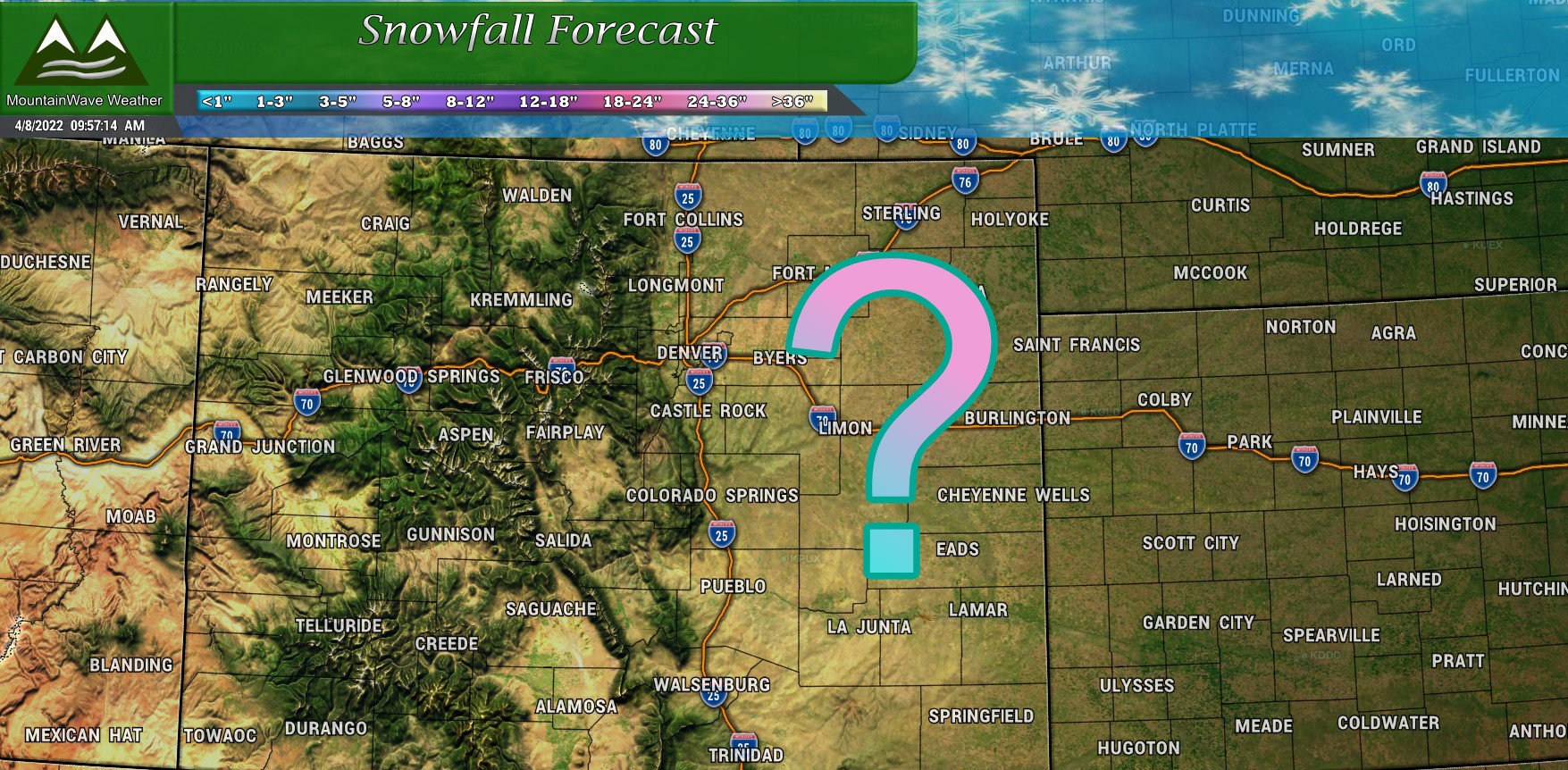
Snowfall Forecast
Don’t event think about it…! Too early yet to say if/how much snow we get in our area. Anyone posting snowfall maps at this point with such model disagreement is looking for attention. If they are, I’d strongly suggest you re-evaluate where you’re getting your weather information from.
Summary
Lots of unknowns for this storm system and hopefully we get a better idea of the details in the coming days… but be patient. This will take some time, not to mention all the other variables that will go into this storm (track, intensity, speed, temperatures, snow melt, etc…) the fact is that it gets harder to predict finer details on later season spring snow storms.
We will do our best to keep you updated as we get new information and details. Stay tuned!
