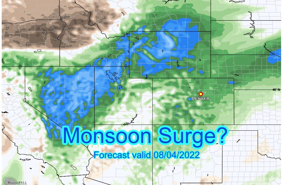
The first week of August has started out like the first 3 of July; hot conditions have been the main story but some folks have benefited from the hit and miss showers every afternoon. Spotty in nature, a large majority of folks haven’t seen any rain the past week and since late July’s Monsoon surge.
A look at the extended forecast shows a change may be on the way this weekend however…
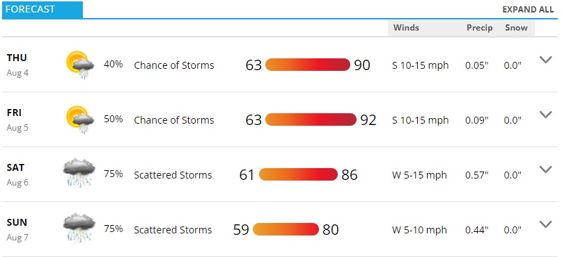
Castle Rock forecast for next 4 days – valid 08-04-2022
Let’s break this shift down a bit
Monsoon Moisture Returns
We can see evidence on models that as our High pressure system to the South moves further East, wrap around flow (remember it’s clockwise for high pressure systems) picks up moisture from the desert Southwest and spins it up towards Colorado.
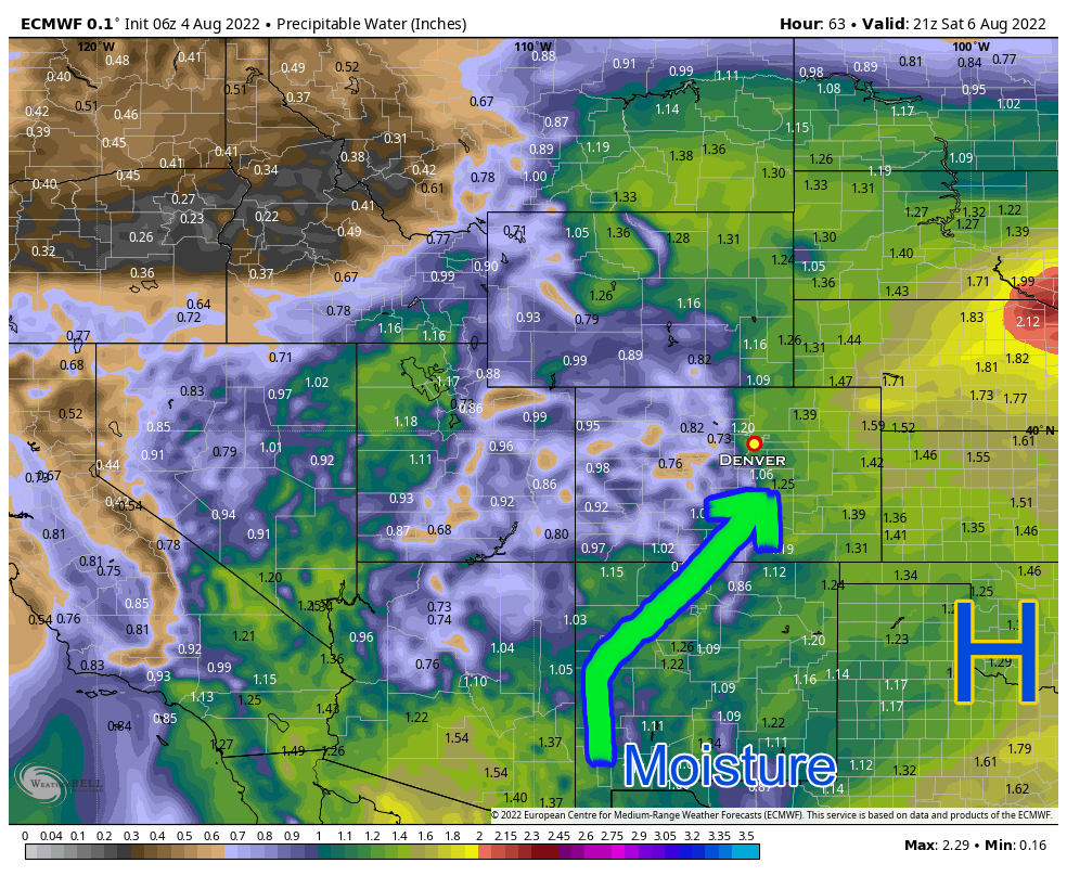
The Euro shows this pretty well with the Precipitable Water product shown above. The higher these values, the more moisture that can be squeezed out of the atmosphere IF storms end up firing. Higher dewpoints and humilities are also closely associated so it may very well feel a bit “muggy” or “sticky” again this weekend. I tend to notice this quite a bit growing up in Colorado, but some folks don’t – especially if you’ve moved here from much higher humidity climates.
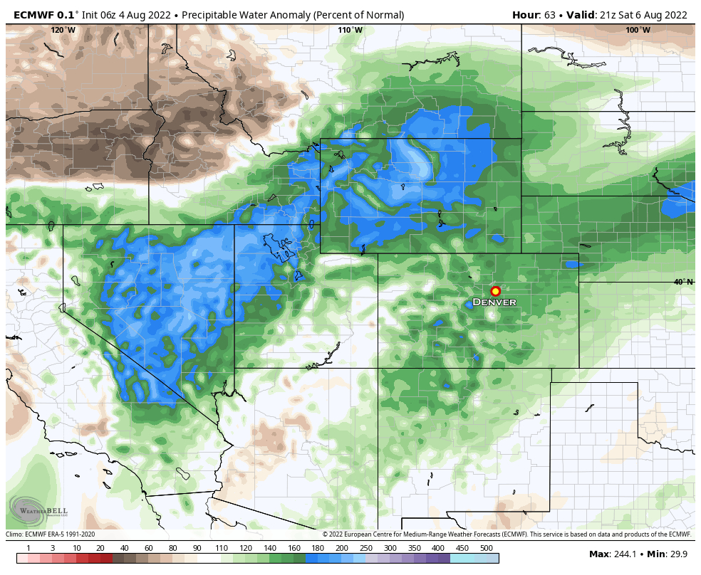
If we show the Precipitable Water Anomaly, we can much more clearly see the corridor of moisture over Colorado.
We Have the Moisture… but Will We See Storms?
Just because we have a ton of moisture in the air, doesn’t necessarily mean we fire thunderstorms and ring out that moisture. We need to have a couple of other things too…
Remember our ingredients for thunderstorms?
- Moisture – we know we will have this
- Instability – ?
- Lift – ?
How do we find that in the models… well models can be bad at nailing down some of these finer details until we get closer to the days we are looking at. Remember the days last week where we had low clouds but no rain at all? Models said we would fire thunderstorms and we didn’t – so as much as I’d like to say the rain is a sure thing this weekend… I can’t!
We can look at a couple of things to try and get a rough idea!
Let’s look at simulated Skew-T’s for Saturday morning and afternoon:
Saturday Morning
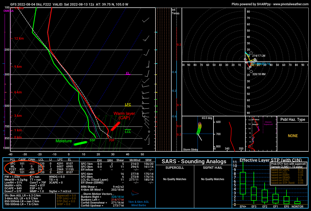
This is the GFS so I always have to mention that before we start – it’s not my favorite long range model but it’s all we have until a bit later today.
The sounding shows a fairly typical summer morning setup:
- Moisture is available, dewpoints are high (this is typical for overnight/early morning hours along the front range of Colorado
- A warm air aloft, known as a CAP. Our lifting mechanism will need to be strong enough to erode that later in the day for storms to form.
- CAPE early in the day doesn’t matter too much, but the forecast is always good to take a look at: rough 650 j/kg shown
So, fairly normal… nothing out of place there.
Saturday Afternoon
This is where you have to be careful when looking at sounding data… you don’t want a sounding when thunderstorms are in the area as they can contaminate the results. Ideally you want to select a sounding of the environment right before storms begin to fire. In this case I chose 3PM.
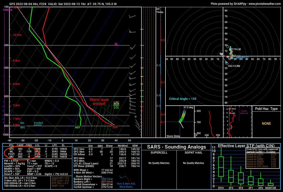
What do we see here?
- This model believes the CAP erodes by the afternoon – this means the model believes surface temperatures will warm enough that the air below the cap warms enough that the temperature profile has warm air at the surface and cooler air aloft. Warm air is less dense than colder air and begins to rise (known as convection.) Should this verify it would be the lifting mechanism we are looking for to fire storms
- Instability is around 300-400 j/kg… this isn’t amazing but it’s enough to do the job. This instability will allow any air rising from the surface to continue rising and condense to form storms.
Final Forecast Verdict
Keep in mind this is a quick run though of a few things I look at when I forecast (there are many more) but it gives you an idea of what I look at. My personal cringe with this right now is I have to rely mainly on the GFS model for soundings, I can use the Euro and other products for simulated stuff on maps, which helps sway me one way or another towards a forecast solution.
You may be wondering then, does a model like the Euro show storms firing? I’ll let you be the judge, below is the simulated IR Satellite for 3PM Saturday:
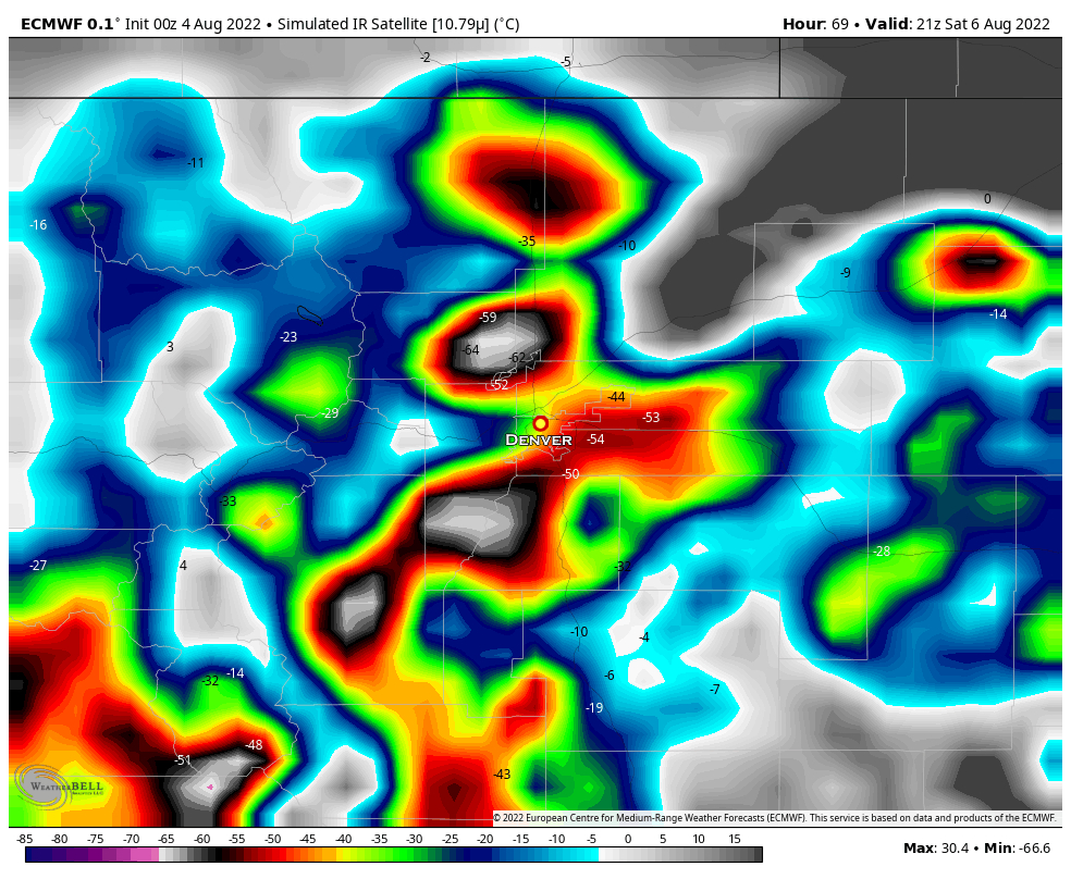 Looks busy doesn’t it?
For This Weekend’s Storm/Rain Chances
Based on some of the forecast data I showed above and a bunch I didn’t have a chance to here’s what we are looking at.
- Cooler temperatures likely
- Thunderstorms likely for most areas, lesser chances as you go further North and East
- Highest confidence in rain totals over the Palmer Divide, Front Range Foothills and Southern Colorado.
- Lower confidence for Northern and Northeastern Colorado – until we get clearer details.
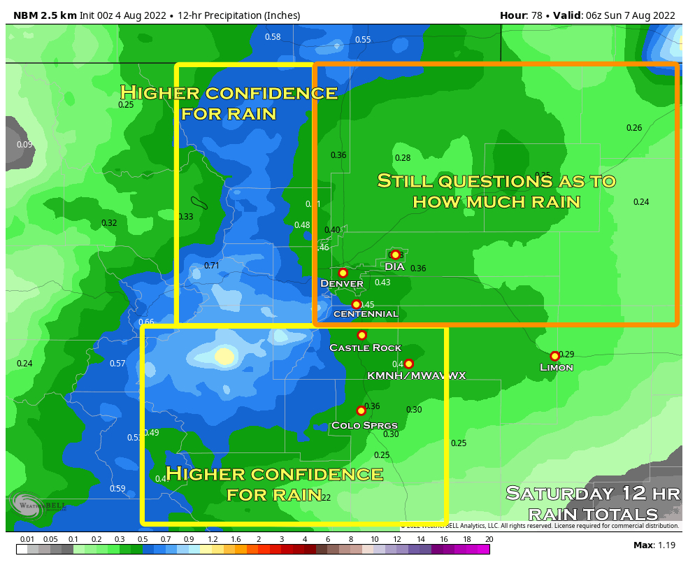
Saturday Forecast Rain Totals
As we are early in the forecast yet and some details could still slide, take the numbers with a grain of salt. Instead, focus on the areas that have a better chance of more rain vs. less and note the trend
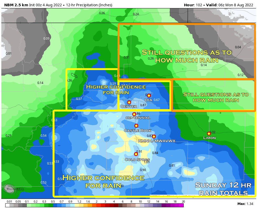
Sunday Forecast Rain Totals
As we are early in the forecast yet and some details could still slide, take the numbers with a grain of salt. Instead, focus on the areas that have a better chance of more rain vs. less and note the trend. My note: I think these totals may be a bit overdone, I’ll be watching closely over the next couple of days to see if they shift lower or confidence increases.
Final Note
If you have outdoor plans this weekend, be ready for afternoon thunderstorms with the possibility of lightning, small hail and heavy rain.
I know you’re going to ask me: “should I cancel my plans?” Nope! Just be prepared, this is not a “cancel my plans” type of setup… remember some folks may not see these storms as they will be spotty. Go ahead as scheduled and just be prepared to move indoors/take shelter if needed!


