Another storm system slated to move through the area late Wednesday and into Thursday. It could possible cause a lot of the same travel headaches we’ve seen with slick roads and icy conditions, but the snowfall totals won’t be much to write home about for 90% of the people reading this article.
Here’s the latest as of tonight…
Current Winter Weather Highlights
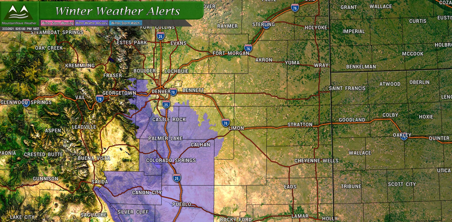
The National Weather service has issued a Winter Weather Advisory for the potential for difficult travel starting at 5PM on Wednesday evening. So far models have decent agreement on timing with concern to when the heavier snow starts – they still differ on amounts and location but we will chat about that in a bit.
Here are the Advisory details:
…WINTER WEATHER ADVISORY IN EFFECT FROM 5 PM WEDNESDAY TO 6 AM MST THURSDAY…
* WHAT…Snow expected. Total snow accumulations between 4 to 8 inches.
* WHERE…The Southern Front Range Foothills, and Castle Rock.
* WHEN…From 5 PM Wednesday to 6 AM MST Thursday.
* IMPACTS…Travel could be very difficult. The hazardous conditions could impact the Wednesday evening commute. Roads will likely become slick and hazardous.
Slow down and use caution while traveling. The latest road conditions for Colorado can be obtained by calling 5 1 1 or by going to www.cotrip.org
Snowfall Discussion and Forecast
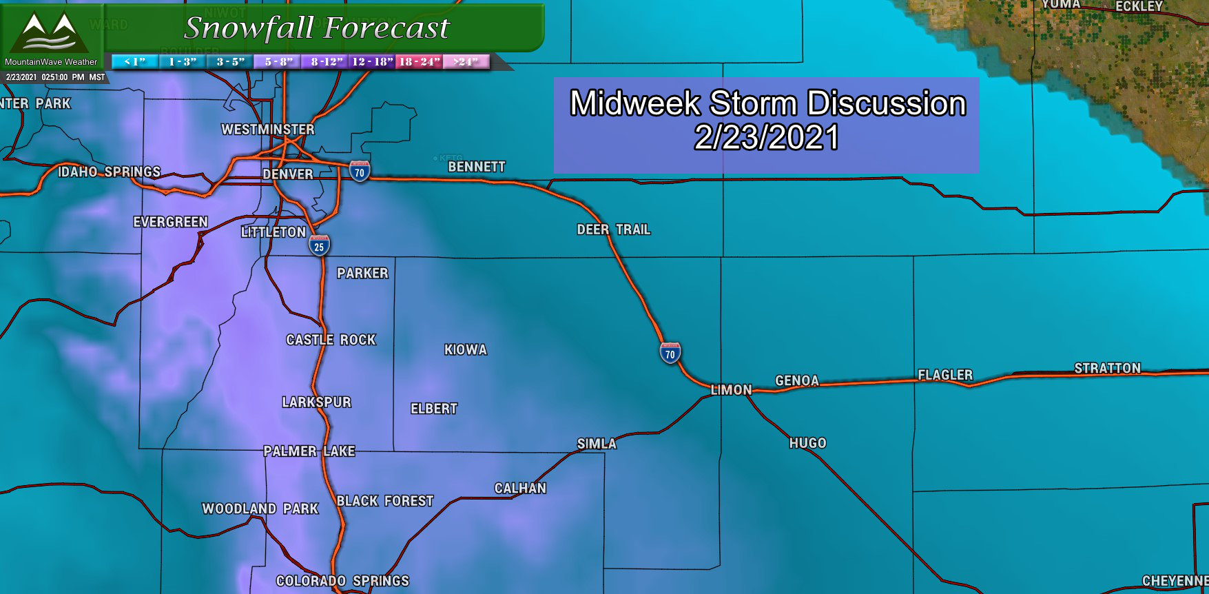
I’ve received a lot of feedback from folks today about how drastically different the news stations are predicting this storm, the main reason behind this is the models don’t agree very well on how much snow will fall for any one area. We can see the typical bullseyes across the Front Range Foothills and Palmer Divide as this storm looks to be primarily an upslope event; we would expect areas that experience enhanced lift due to terrain (upslope) to be able to squeeze more moisture out of the atmosphere.
The fact is whichever models and bias each TV station has, that is what you will see translated in the forecast. When forecast confidence is high, all the TV stations should have a forecast farily close to each other… when confidence is low as it is with this storm – you will see a wide array of results.
Here’s our thinking on ranges for the Palmer Divide.
Expected snowfall through Thursday morning – notice the wider ranges as forecast confidence is still overall low with this storm system
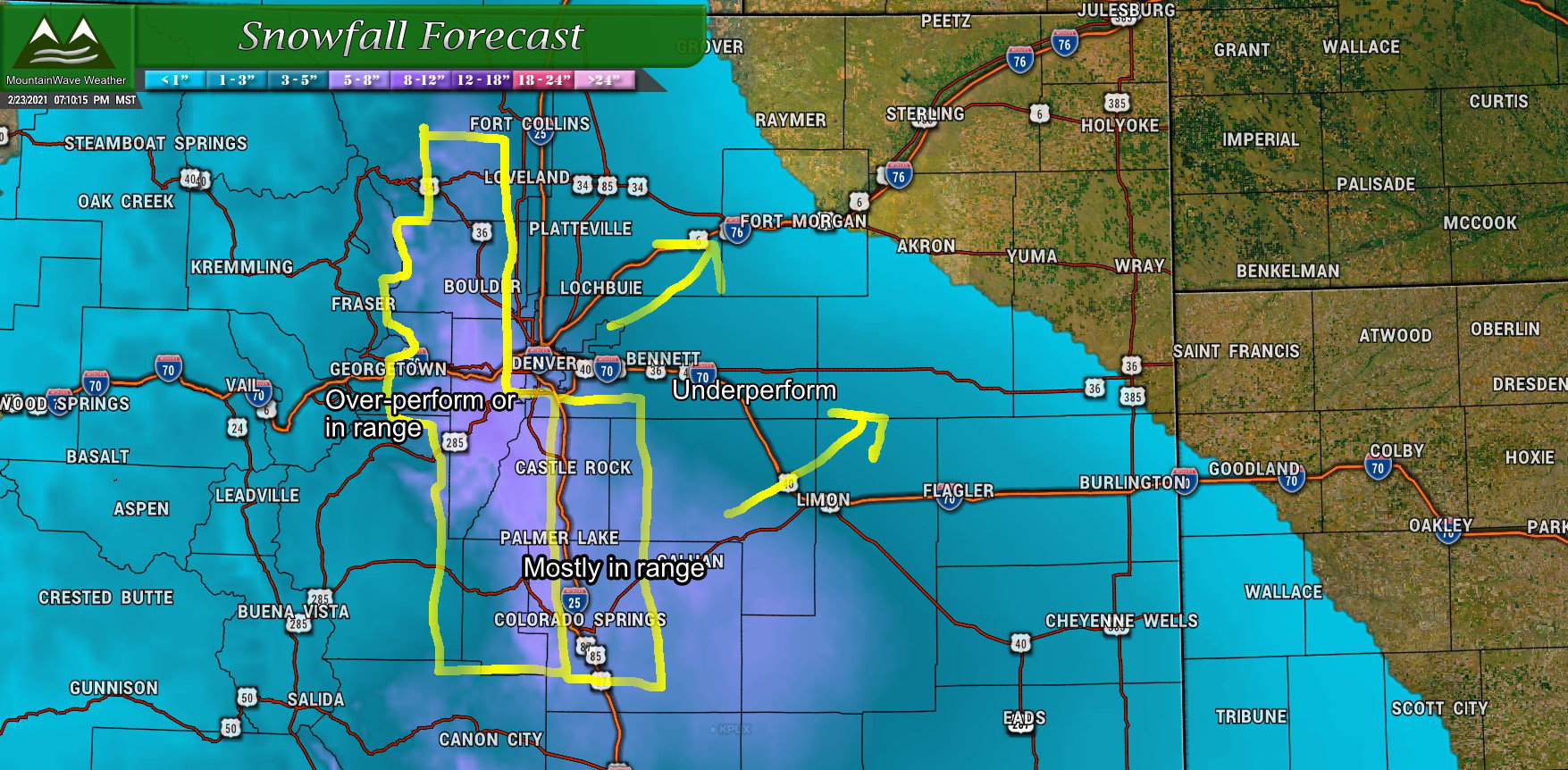
The big question mark here will be how much areas away from the upslope will recieve. I expect a pretty sharp gradient as you get close to and cross I-25 so it is possible we could see some busts low with this storm especially East of the highway. On the other hand, a boom for higher totals is certainly possible especially with those terrain favored areas right along the highway.
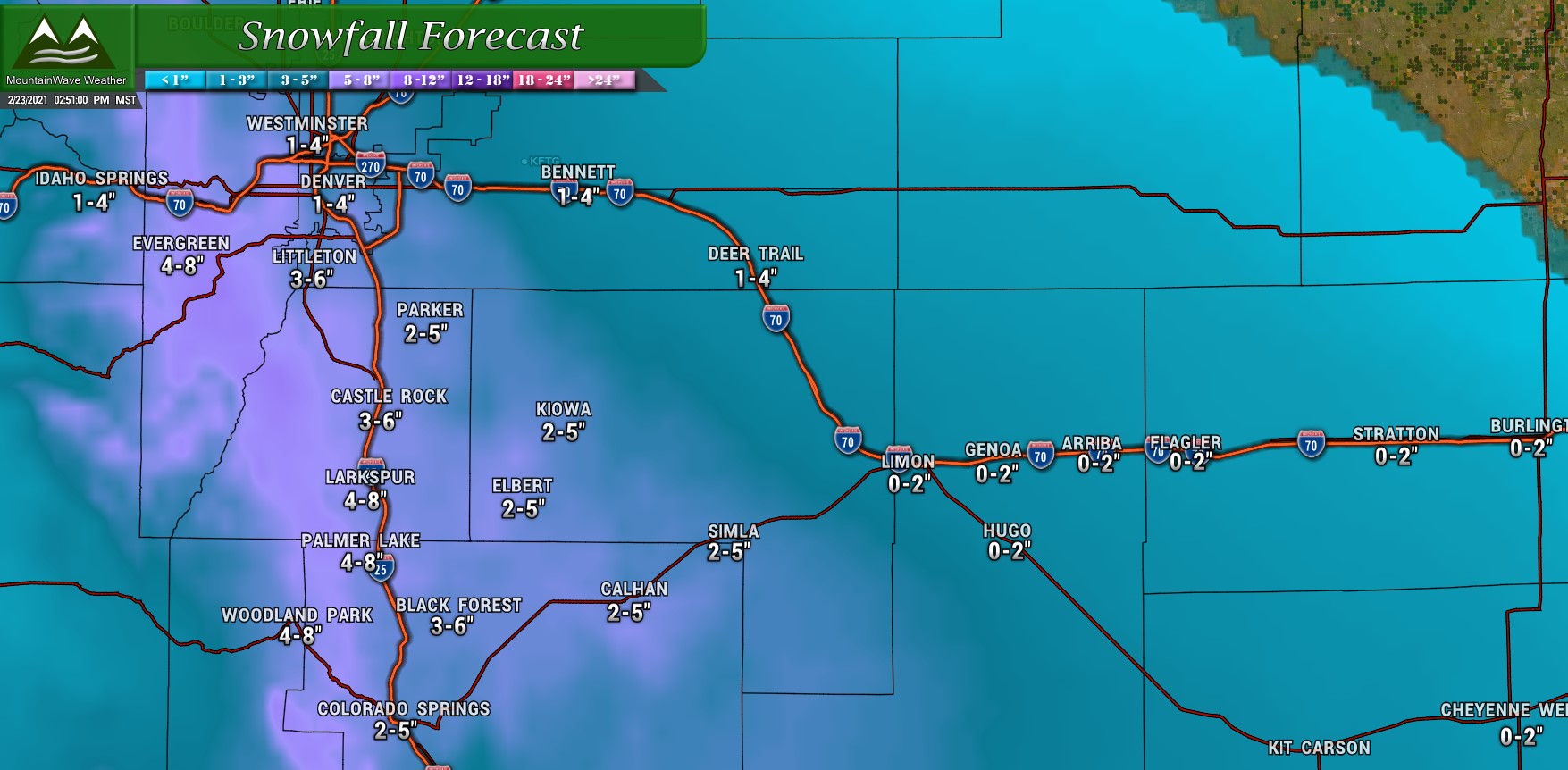
Here’s some pinpoint numbers for a few other areas, to get a range +/- 1-2 inches on each number.
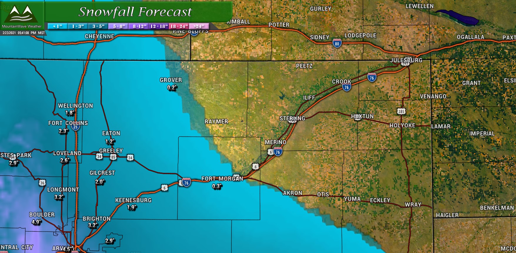
Northern Colorado expected snowfall through Thursday AM
As you can see, nothing to write home about with Northern Colorado. Snowfall accumulation will drastically increase as you move further North. The low pressure center will drop too far South to provide good upslope or moisture to most of these areas… your exception may be the hills in and around Boulder. That area has overperformed on a large amount of storms so far this year.
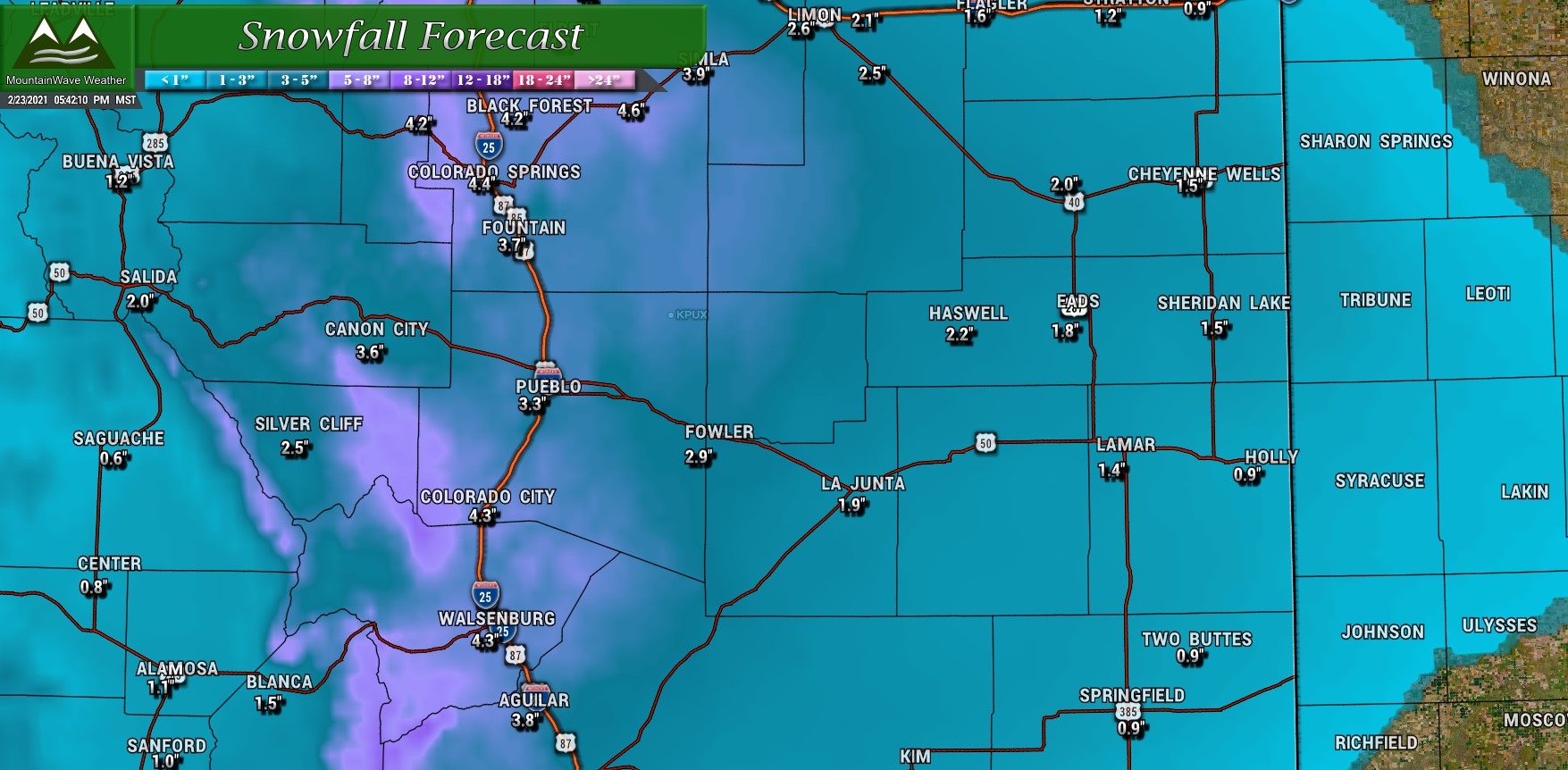
Southern Colorado expected snowfall through Thursday AM
As you can see from this graphic though, Southern Colorado will see a bit more widespread snow with those terrain favored areas West of I-25 doing best.
Timing/Impacts
Models generally agree on snow starting between the 4-7PM timeframe, the advisory is in effect starting at 5PM though so keep in mind conditions could begin to deteriorate around that time if snow moves in a bit earlier.
For impacts, expect roads to become slushy, icy and snowpacked into the evening and overnight hours
The Thursday morning commute will likely be impacted in some form with icy/snowpacked and slick conditions lasting into Thursday morning
A Quick Note About Upslope With This Storm
The wild card with this entire storm system is that the upslope will be trenched across the front range but overall it is fairly week. We don’t have the jet stream overhead to enhance lift and the low pressure center looks a bit too far South to bring us a ton of energy.
This means it is likely that areas away from the terrain (the only lifting mechanism we have with this storm) will most likely bust pretty low on snowfall. My thinking is using I-25 as a dividing line for now and realizing that areas East of the highway may be ultimately very disappointed in how much snow they see.
This will be a tricky forecast with extreme gradients in snowfall so that is one thing we will have to watch. Wouldn’t be surprised to see a scenario similar to below set up:
Summary
As always, we will keep an eye on this one for any changes, be sure to keep an eye on our site or Facebook page for any updates – we will be updating if/as needed on Wednesday.
