Around lunchtime yesterday, many folks reached out as they received special weather statements and severe weather warnings on their phones.
Many had assumed that we would see no storms… not sure where that information came from – but it wasn’t me…
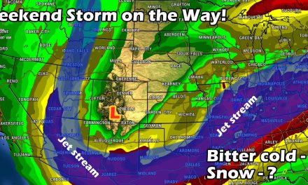
Here were my thoughts on Sunday about the upcoming week:

This range pretty true on Monday, Douglas County was the only area to really see a severe storm but it wasn’t the typical severe storm we’ve been seeing lately with hail and tornadoes.
The severe storm warning issued on Monday was for wind gusts of 60-70mph – winds in those ranges can cause damage so a Severe Thunderstorm Warning is often issued when a thunderstorm is producing that type of wind.
Since I really wasn’t watching the weather much yesterday, I decided to go back and see what was going on at the time and what made the atmosphere and that storm tick.
Here’s a short writeup of my findings.
Storm Analysis
Storms Build to the West
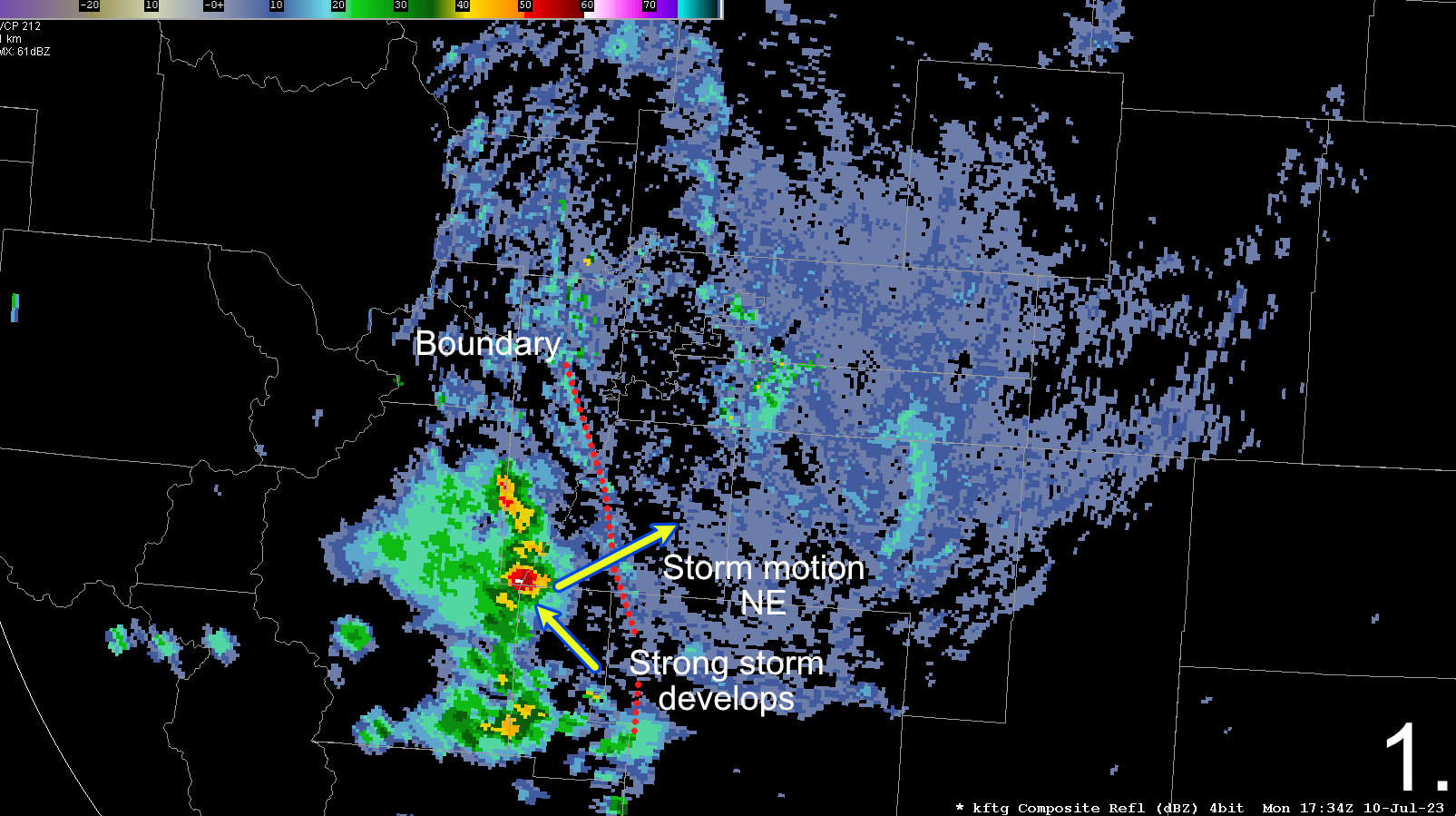
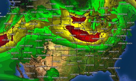
At around 10:30AM, storms can be seen building on the radar towards Southwestern Douglas County. The general motion with these storms was towards the Northeast at roughly 20-25mph.
Additionally there was a boundary set up from NNW to SSE just West of this line of storms in Jefferson, Douglas and El Paso counties.
From some of the forecast soundings I had seen, the atmosphere was fairly well capped meaning these storms probably had lift provided by terrain. The thinking with this setup though would be that these storms would struggle to survive as they move off the higher terrains.
Main Storm Systems Collapse / Additional Storms Build to South
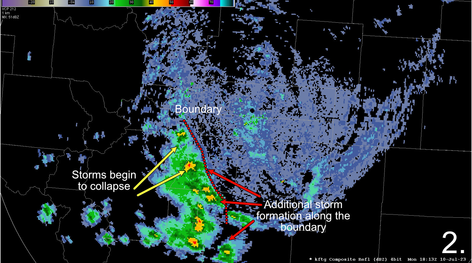
As expected, around 11AM the storms began to collapse on the Northern end of this complex while new storms began to form along the boundary to the South.
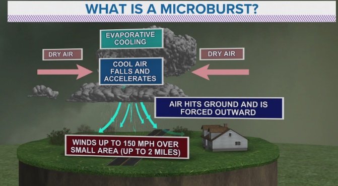
When storms collapse they become what we call “outflow dominant” meaning they no longer have solid inflow (warm moist air) being pulled into the storm. When this happens the storm cell is effectively dying off. A couple of things happen when we reach this stage:
- Inflow and updraft disappear
- Cold, dense air begins falling out of the storm
- Strong winds or microbursts can form along and ahead of the storm cell
We know strong downward winds are likely when the storm reached this stage, but microbursts are more common in very warm and dry environments – this is what we had yesterday. Remember how hot it was?
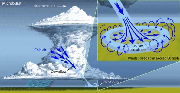
As the cold air falls out of the storm, it hits the ground and spreads out in all directions. Since we had higher terrain to the West of the storm complex yesterday and wide-open plains in front of it – I would expect much of the wind energy to actually fan out in front of the East part of the storm. There is a lot more to this process including the evaporative cooling aloft and how dry the air is at the surface, but I’ll spare you all from those technical details for the sake of simplicity.
This is my theory at this point based on what I know, but if that’s indeed what happened we should be able to see evidence of this on radar at some point.
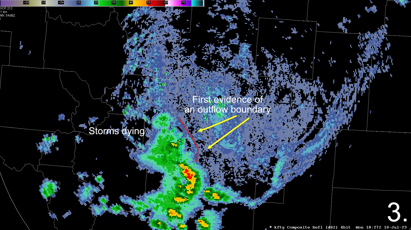
First Evidence of Outflow Boundary
Stepping ahead slightly to 12:30-ish we see the first faint confirmation that a outflow boundary or gust front has formed in front of the collapsing storm complex.
Many folks in Castle Rock and surrounding areas messaged me about strong winds around this time.
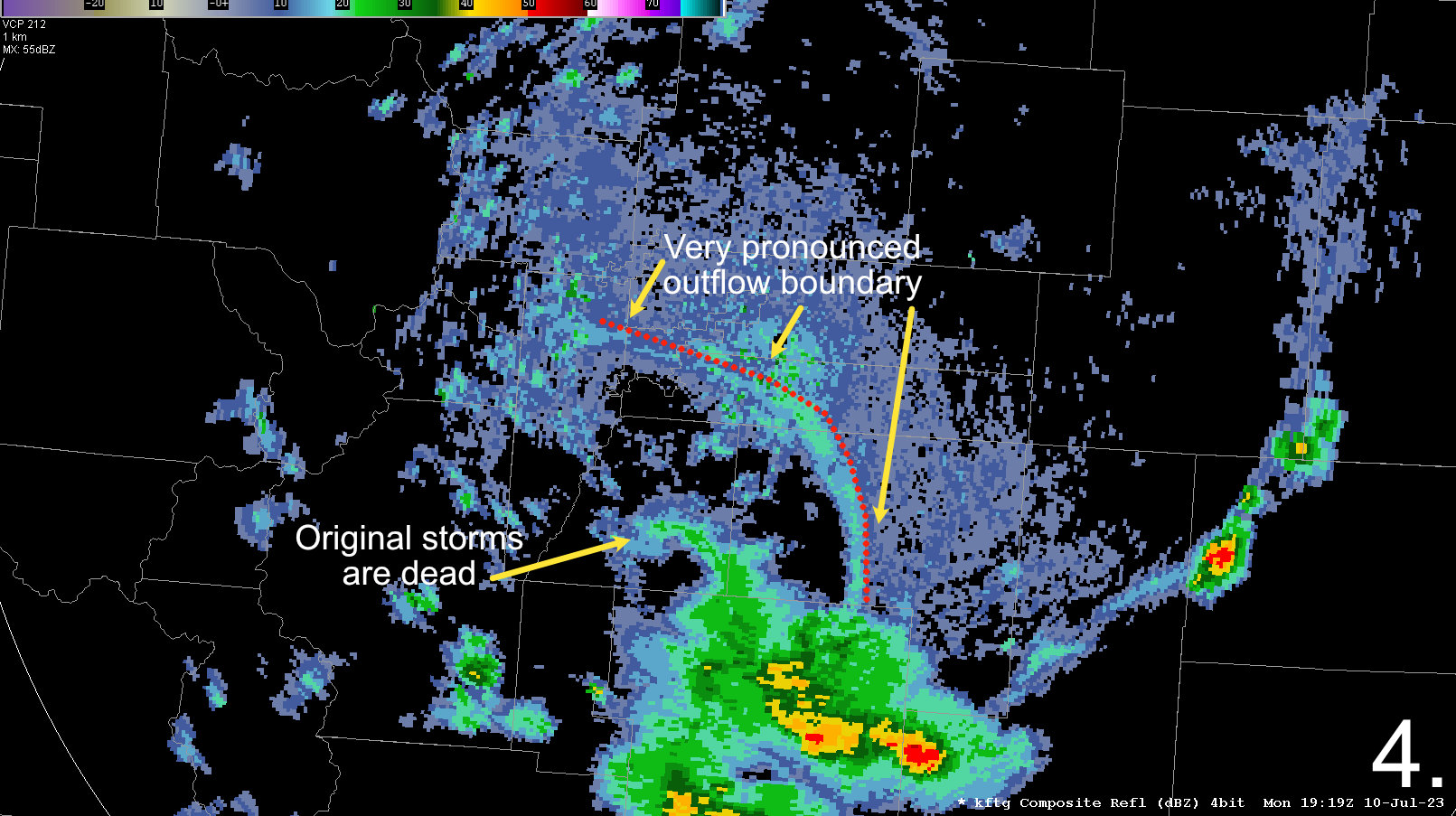
Skipping Ahead – Verification
I’m going to jump ahead to roughly 1:20PM
We can see strong evidence that the original storm system has completely collapsed and a strong outflow boundary is spreading outwards away from these collapsing storms.
Additional storm formation occurs to the South and East of Colorado Springs. Those storms last a bit longer but ultimately suffer the same fate as the storms that moved across the Palmer Divide.
So we can put a timeline together of what happened here based on radar evidence:
- Storms form over the foothills in a fairly stable environment, this means they had help from the terrain as a lifting mechanism
- Those storms moved Northeast into a more stable environment across Southwestern Douglas County and began to collapse
- As the storms collapsed, they output a ton of cold and dense air at their base and immediately ahead of the storm
- This created an outflow boundary/ gust front that spread out in front of the storm
- These winds were 60-70mph prompting special weather statements and severe thunderstorm warnings
- The outflow boundary moved out onto the plains – it did not appear to spur any additional thunderstorm development… why do you think that was?
Tried not to get to sciency with this write-up but hopefully it sheds a bit of light on what caused our pop-up severe storm yesterday.
