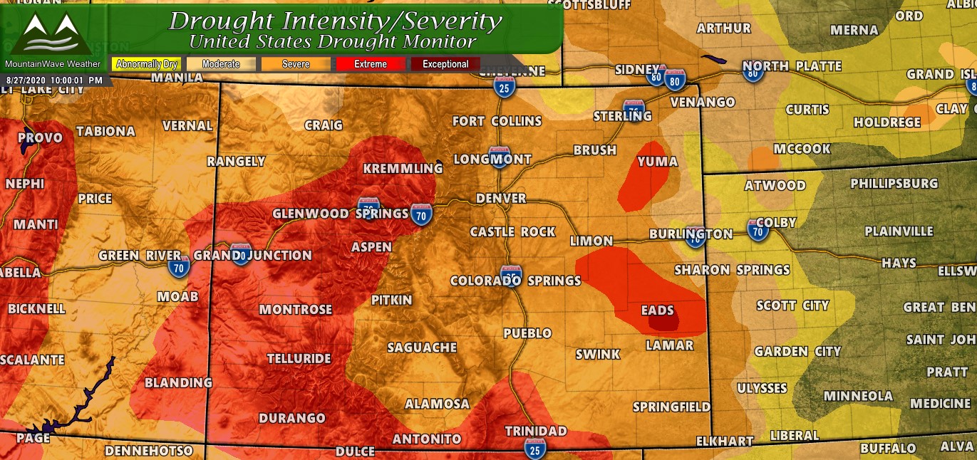
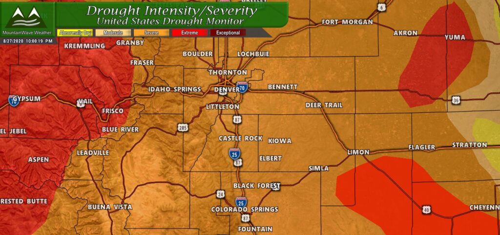
The latest drought monitor update is out for the U.S. and it’s not particularly good news for Colorado and much of the West. Most areas of “abnormally dry” and “moderate drought” conditions have been replaced by “severe drought” and a major expansion of “extreme drought.” For the Colorado Front Range and Palmer Divide regions, severe drought has taken hold of both of those areas. The mountain areas West of the Continental Divide are now in extreme drought which means things are getting pretty bad.
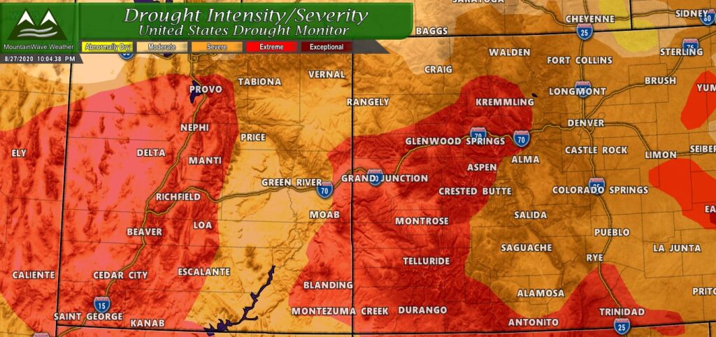
If we zoom out and move a bit to the West we can see conditions are rapidly deteriorating out that way… this is why crews are struggling so much with getting fires under control in the Western part of the state…
The latest text update describes some of the thinking behind serious upgrades to drought conditions across the West:
In the Four Corners states, a combination of factors have led to the current drought depiction on the map—starting with an extended period of above-normal temperatures across Arizona, Colorado, and New Mexico beginning in mid-April and extending into mid-June. This warming triggered a premature melting of the snowpack across the mountain ranges of the Colorado River Basin.
As summer continued, the extreme heat and a weak monsoon exacerbated the situation with numerous heat-related records broken across the region during July and August. According to NOAA NCEI, the April-July 2020 period was the 2nd driest on record in the Southwest Climate Region (Arizona, Colorado, New Mexico, Utah) while on a state level, the May-July 2020 period was the 2nd warmest on record for both Arizona and New Mexico.
In terms of precipitation, April-July 2020 was the 3rd driest on record for Colorado, 4th driest for New Mexico, 5th driest for Colorado, and 6th driest on record for Utah. As of August 1, statewide reservoir storage was slightly below normal in California, Colorado, Nevada, and Oregon with New Mexico worse off at ~50% of normal while above-normal levels were observed in Arizona, Idaho, Montana, Utah, Washington, and Wyoming.
NWS Denver Precipitation Reports Show Dire News
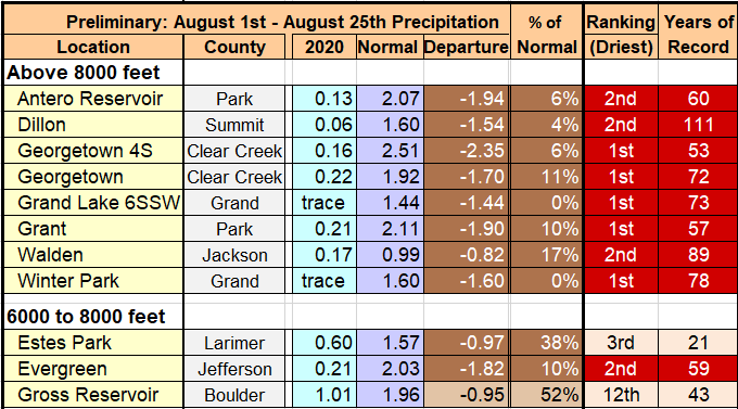
A new report from the NWS this week showed that many areas in Colorado are reporting at least their top 10 driest Augusts with many areas reporting their top 1, 2 or 3 driest Augusts on record. This is not going to help our drought situation going into September much as a dry August combined with record high temperatures will lead us into what is typically a quieter and drier weather month in September.
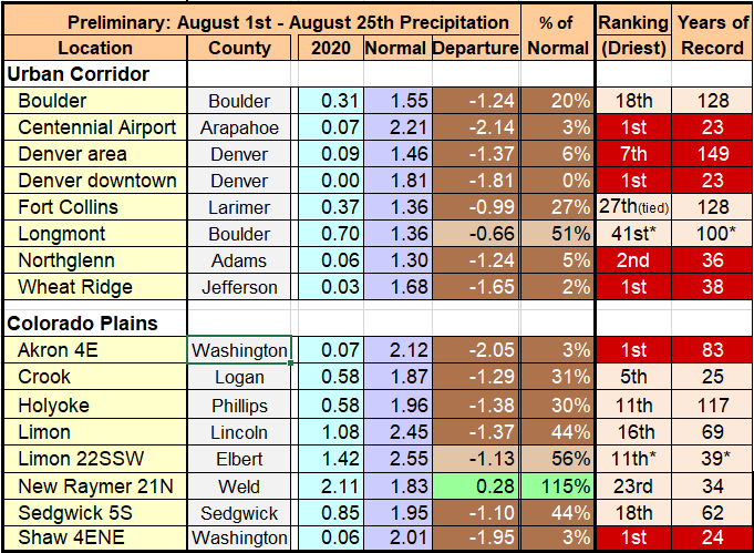
Nearly every official station across the urban corridor and plains is showing precipitation well below average for the month of August
Colorado Residents Should Begin Preparing For Next Year if Drought Continues
Due to a few good winters – reservoir storage is in relatively good shape for the front range this year. If we see continued drought conditions through winter and low snowpack, some areas could be facing water shortages by next spring.
Every person in Colorado should be preparing for low water storage, extreme fire conditions and general dryness for the foreseeable future.
We see no indications for a period of “drought busting” consisting of higher than average precipitation over long periods of time in our immediate future. In fact some indications are that drought conditions may last well into next year… it’s hard to tell but we do know that the front range historically does poor on moisture during the fall and winter months during La Nina – which we expect this year.

