The storm is behaving largely as expected to this point so no major changes from a forecast perspective. I did tweak a bit of the snowfall forecast to be more in line with thinking after more model data and seeing some of the early storm evolution.
Other than that, updates to winter weather highlights, timing and impacts along a bit of useful information for this storm.
Details posted below!
Current Winter Weather Highlights
NWS has upgraded Denver’s Winter Storm Watch to a Winter Weather Advisory, confidence has risen enough in the chance for bursts of heavy snowfall that could deteriorate travel conditions enough. Still not confident the city sees a ton of snow accumulate, but it could come down fast enough for some problems.
Additional winter weather highlight information around the Palmer Divide is also included.
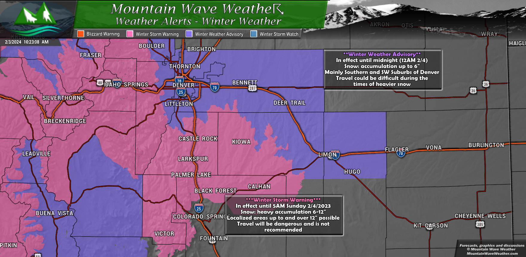
Palmer Divide above 6,000 Feet in Elevation
***Winter Storm Warning***
In effect until 5AM Sunday 2/4/2024
Snow amounts between 6-12 inches are possible – locally higher amounts are possible
Dangerous travel and rapidly changing travel conditions will exist – non-essential travel not recommended
Palmer Divide below 6,00 Feet in Elevation
**Winter Weather Advisory**
In effect until 5AM Sunday 2/4/2024
Snow amounts between 4-10 inches are possible – will be highly dependent on elevation
Difficult travel conditions will exist
Denver Metro Area/ I-25 Corridor/ Denver Suburbs/ East Denver and Denver International Airport
**Winter Weather Advisory**
In effect until 12AM Sunday 2/4/2024
Snow amounts between 4-10 inches are possible – will be highly dependent on elevation (Western and Southwestern Suburbs with the highest chance of higher snowfall amounts)
Difficult travel conditions will exist
Timing and Impacts
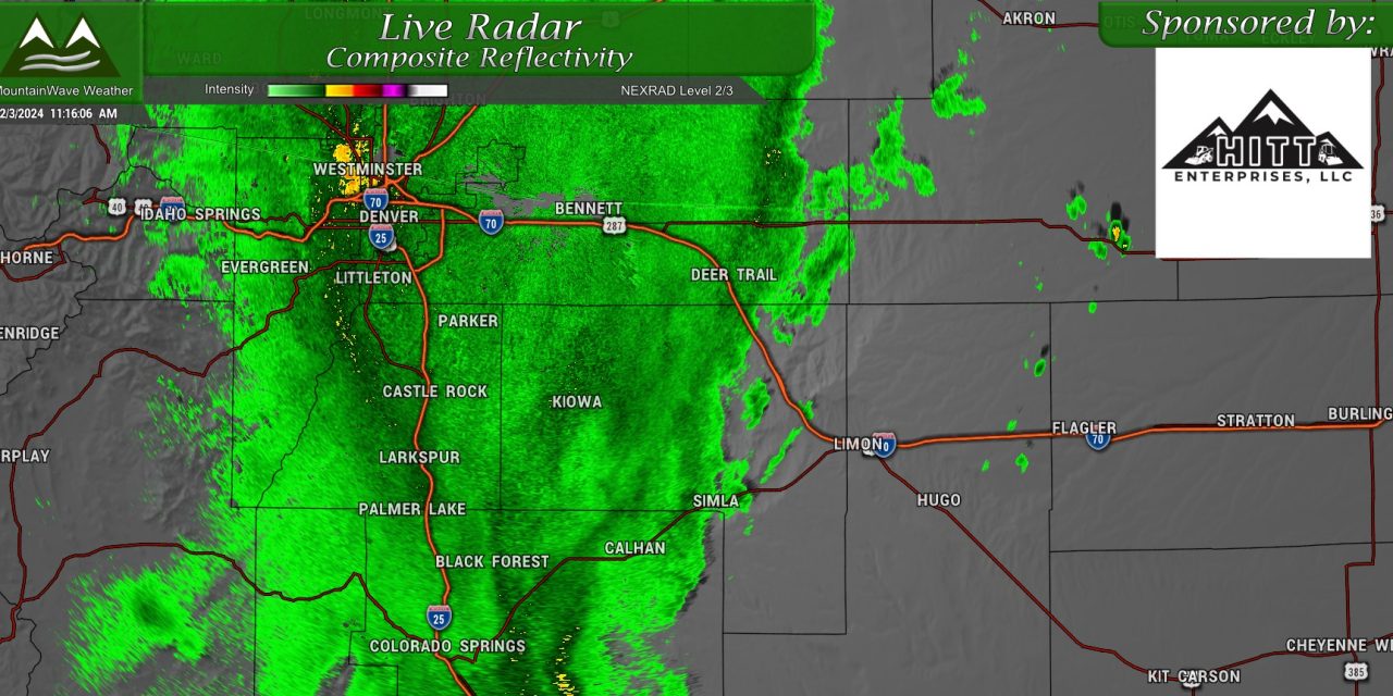
Heaviest snowfall still expected this afternoon and evening. Don’t get caught unaware!
For this afternoon and evening, minor impacts due to heavy snowfall and snowfall accumulation exist. Mainly in and around Denver and points North and East.
We are still expecting moderate to potentially high impacts to travel this afternoon along the elevated areas of the Palmer Divide. Generally, travel between the Tech center and Colorado Springs is the area you will have to watch most carefully.
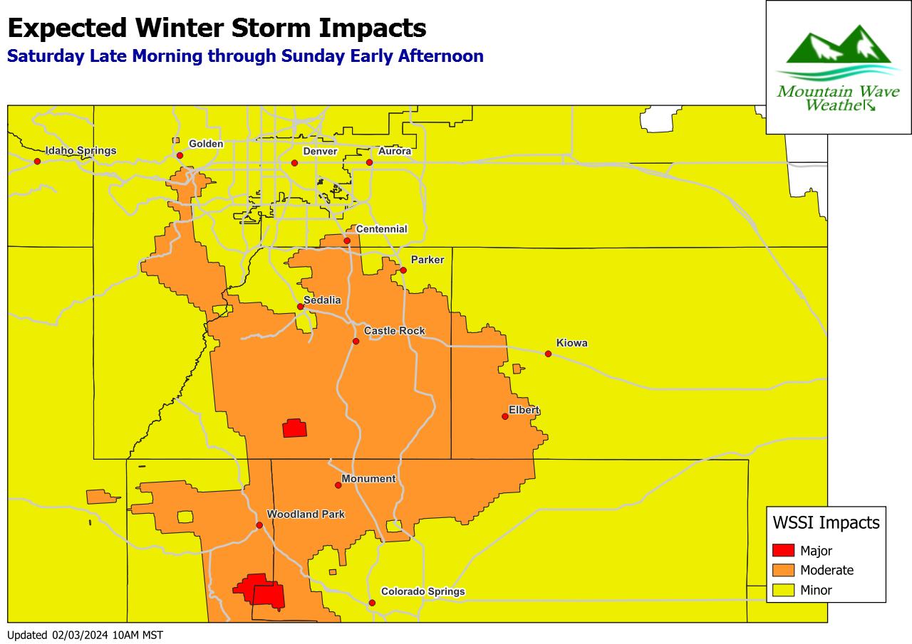
In terms of specific timing for specific impacts, that information is below:
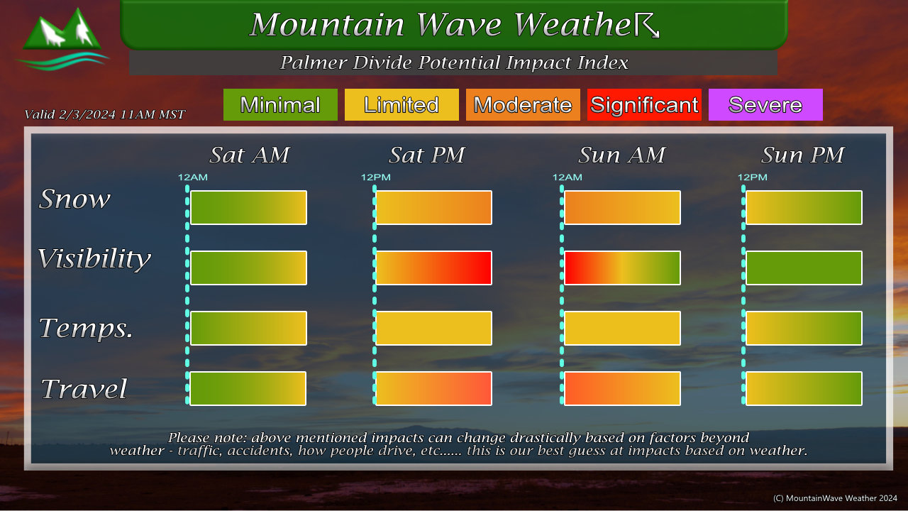
You’ll notice the likely biggest impacts for snow and visibility occur Saturday afternoon and evening and potentially into early Sunday morning.
For travel in general, expect slushy, slick and icy/snow covered roads under the heavier bands of snow Saturday afternoon and evening.
The absolute worst time for travel looks to be during that timeframe.
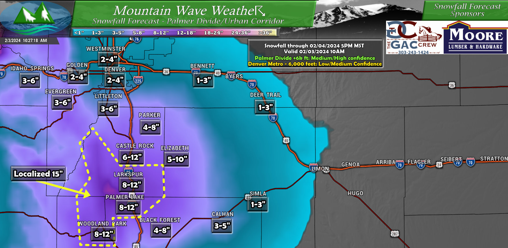
Updated Snowfall Forecast
Here’s the latest thinking on snowfall amounts. The changes:
- Slightly bumped up snow amounts for Castle Rock and surrounding areas due to higher confidence from model guidance this morning
- Bumped up snow amounts for areas South and Southwest of Castle Rock. Models continue to paint a bullseye over these areas
- Also mentioned possibility that some of those localized areas see up to 15″ of snow (probability is small-ish but still high enough to warrant a mention)
- Bumped up snow amounts for Southern suburbs of Denver
- Bumped up snowfall a bit in and around Denver, still possible these areas over-perform a bit in localized spots but I think most areas should finish in range
Summary – End of Forecast
That’s it for forecasting at this point, the storm is here and it will do what it’s going to do.
From here on out, I’ll have any minor updates or changes (or if something busts high or low) most likely on social media.
You can always check the Facebook page for that information.
Stay warm and stay safe!
