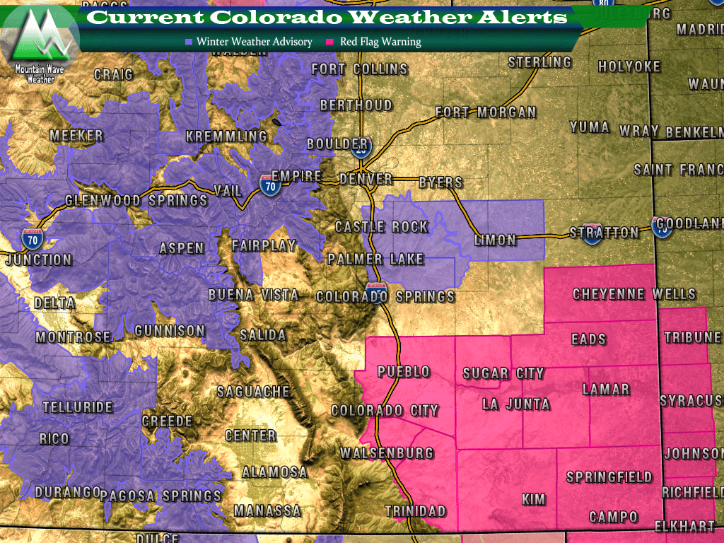
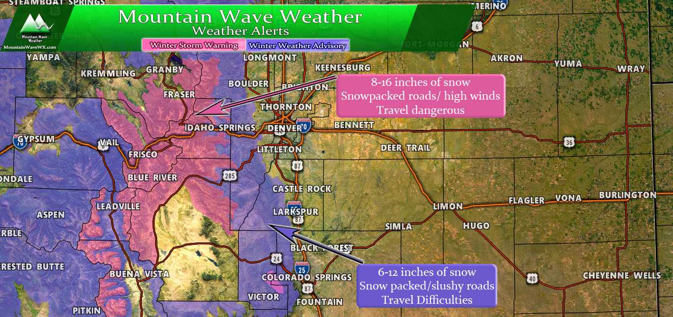
Current weather alerts for Colorado as of 9AM March 18, 2018
There has been a ton of uncertainty with this storm system and there still remains quite a bit, but the good news things are coming a bit more into focus. Along the front range, the main area of concern with this storm is right in our neck of the woods along the Palmer Divide. The National Weather Service has issued weather advisories along the Palmer Divide, here are the details:
COZ041-046-181800-
/O.EXB.KBOU.WW.Y.0017.180319T0100Z-180319T1200Z/
Castle Rock-Limon-
Including the cities of Castle Rock, Elbert, Fondis, Kiowa,
Larkspur, Agate, Hugo, Limon, and Matheson
356 AM MDT Sun Mar 18 2018

...WINTER WEATHER ADVISORY IN EFFECT FROM 7 PM THIS EVENING TO
6 AM MDT MONDAY...
* WHAT...Snow and blowing snow expected. Total snow accumulations
  of 3 to 6 inches are expected.

* WHERE...Castle Rock and Limon.

* WHEN...From 7 PM this evening to 6 AM MDT Monday.

* ADDITIONAL DETAILS...Plan on slippery road conditions. In
  addition, areas of poor visibility are likely. Winds gusting
  as high as 50 mph will cause areas of blowing and drifting
  snow.

PRECAUTIONARY/PREPAREDNESS ACTIONS...

A Winter Weather Advisory for snow and blowing snow means periods
of snow and blowing snow will cause primarily travel
difficulties. Be prepared for snow covered roads and limited
visibilities, and use caution while driving. The latest road
conditions for the state you are calling from can be obtained by
calling 5 1 1.
More Than 1 Forecast For This Storm
How much snow you get out of this storm will largely depend on where you live, your elevation and how quickly the rain changes over to snow tonight. Areas around Denver and to the North will see little snow accumulation and may see little precipitation due to downsloping off the Cheyenne Ridge. We’ve talked about this downsloping in articles here on MountainWave WX before…
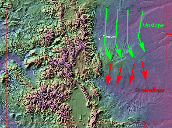
Strong Northerly winds accompanying this storm will mean downslope (dry air) for areas around and North of Denver… but means stronger upslope (better moisture) around the Palmer Divide Region.
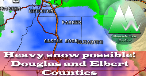
Douglas County (Castle Rock, Franktown, Larkspur, Parker, Highlands Ranch)
Due to the warmth of this storm, elevation will make all of the difference here. Areas like Parker and Highlands Ranch (areas generally below 6,000 feet) will get significantly less snow accumulation… but not to say they won’t see moisture. Most of their precipitation will fall as rain however.
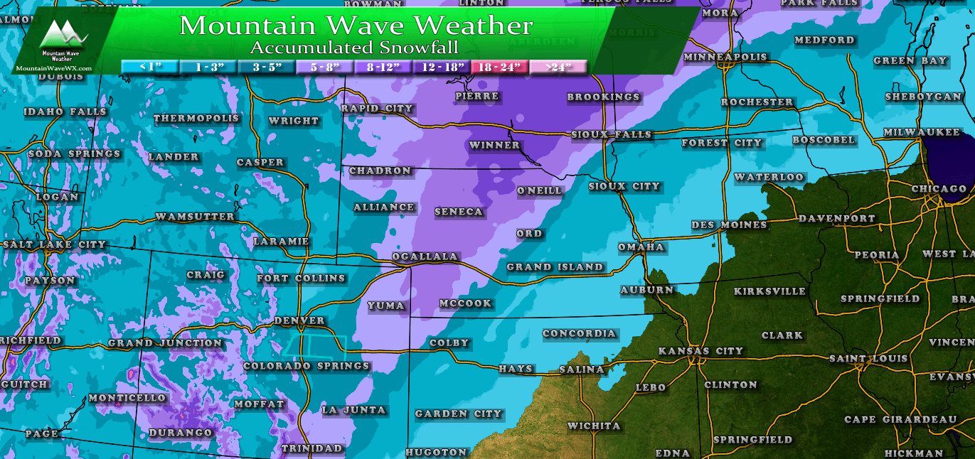
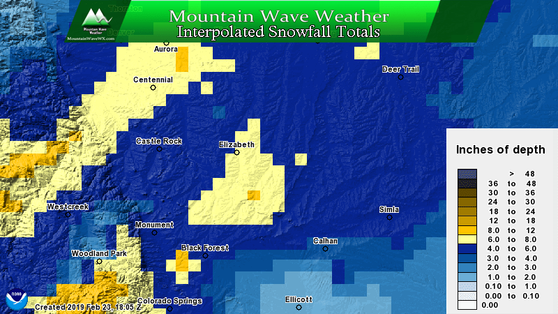
Accumulation
Parker: 1-3 inches total
Highlands Ranch: 1-3 inches total
Castle Rock: 4-8 inches total
Larkspur: 5-10 inches total
Franktown: 6-12 inches total
Elbert County (Elizabeth, Elbert, Limon, Kiowa)
The higher terrain and the fact that the storm is set to move Eastward rather quickly once it gets organized puts the bulls-eye right along eastern Douglas and most of Elbert County. For that reason, we expect higher snowfall totals over this region.
Accumulation
Elizabeth: 4-8 inches total
Elbert: 5-10 inches total
Kiowa: 5-10 inches total
Limon: 5-10 inches total
Timing
This is the really important part, because I imagine a lot of folks will be out and about this afternoon and evening.
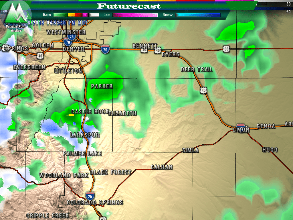
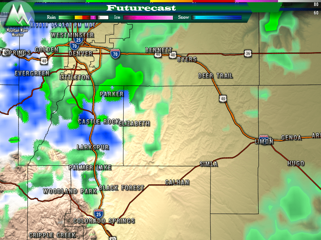
5PM snapshot of conditions along the front range. Most precipitation is still falling as rainfall but the main energy of the storm is moving in.
After about 3pm most models show showers and even a few thunderstorms moving in.
Transition over to snow begins around 6-7PM.
One thing to pay close attention to is when the rain to snow switch over begins. Due to the convective nature of this storm (lots of instability and lift in the atmopshere) snowfall could be quite heavy at times.
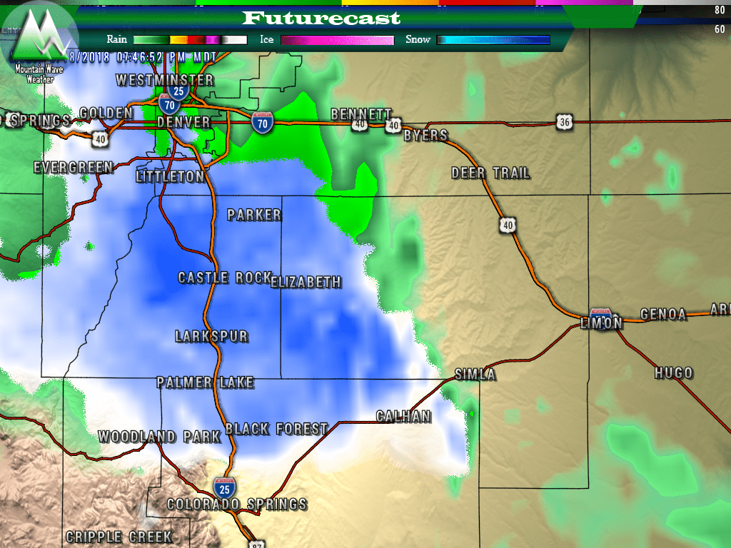
Around 8 to 9PM models show all snow in Douglas and Elbert county
By 8 or 9pm we show a transition all to snow, keep in mind this will be moderate to heavy snowfall so road conditions will deteriorate quickly.
Impacts
- Main impacts will be moderate to heavy falling snow
- High winds will be possible, especially East of the I-25 corridor
- Roads will become icy and snow packed very quickly under the heavier snowfall bands
- Travel conditions will be the toughest across the Palmer Divide
Summary
REMEMBER:
- Good idea to be home and off the roads by 6 or 7
- Strong winds and heavy snowfall could create blizzard conditions, especially over the Palmer Divide
- Monday morning commute could be impacted, especially South of Denver
We’re getting a good grasp on this storm, but like most spring storms this time of year; this one could still throw some curveballs our way. Wouldn’t be surprised to see higher snowfall amounts become likely as we move through the afternoon, but then again I wouldn’t be surprised to see the storm completely fall apart either.
My advice right now is treat this storm like it means business, be off the roads by the evening and make sure you’ve got everything ready. This storm will be here and gone before you know it so this is not a “go to the grocery store and grab all the food” type of storm. It will be out of here before you even wake up Monday morning.
If this storm looks like it’s strengthening or falling apart with this afternoon’s data I’ll be sure to let you know!
