A historic storm is slated to move into the area starting Wednesday evening and night as an unusually strong “arctic” air mass will move into Colorado. No doubt about it, this is some of the coldest air I’ve seen in October during Colorado and I’ve lived here for awhile! I’m going to change up the layout of my weather posts a bit; we will talk about the important “need-to-know” stuff first and the analysis will be after that.
Watches/Warnings/Advisories – as of 1PM 10/9/2019
Wednesday afternoon
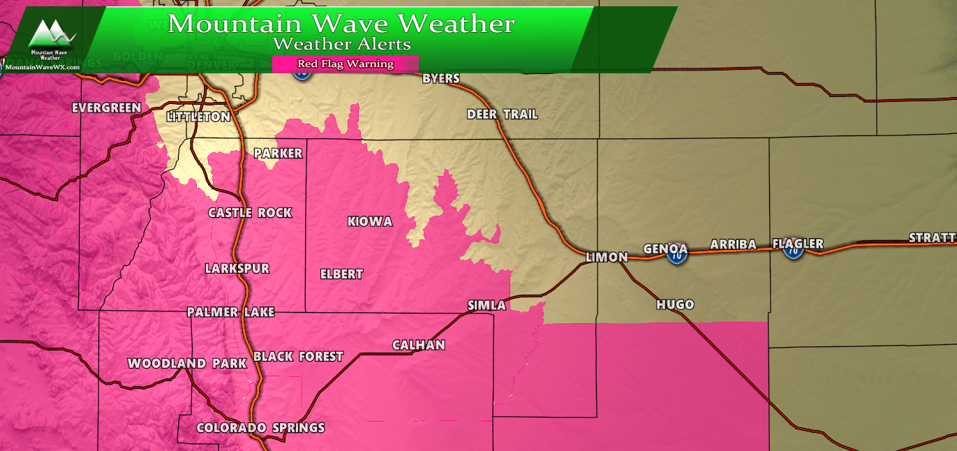
***Red Flag Warning***
Elbert/Central and East Douglas Counties Above 6000 Feet-
Southeast Elbert County Below 6000 Feet/South Lincoln County-
357 AM MDT Wed Oct 9 2019

...RED FLAG WARNING REMAINS IN EFFECT FROM NOON TODAY TO 6 PM MDT
THIS EVENING FOR WIND AND LOW RELATIVE HUMIDITY FOR THE PALMER
DIVIDE AREA AND SOUTHERN LINCOLN COUNTY...

* Affected Area...Fire Weather Zones 241 and 247.

* Winds...Southwest 10 to 20 mph with gusts up to 30 mph.

* Timing...Wednesday from Noon through 6pm MDT.

* Relative Humidity...As low as 8 percent.

* Impacts...Conditions will be favorable for the rapid ignition,
  growth, and spread of fires.

PRECAUTIONARY/PREPAREDNESS ACTIONS...

A Red Flag Warning means that critical fire weather conditions
are either occurring now....or will shortly. A combination of
strong winds...low relative humidity...and warm temperatures can
contribute to extreme fire behavior.
Wednesday Evening through Thursday Morning
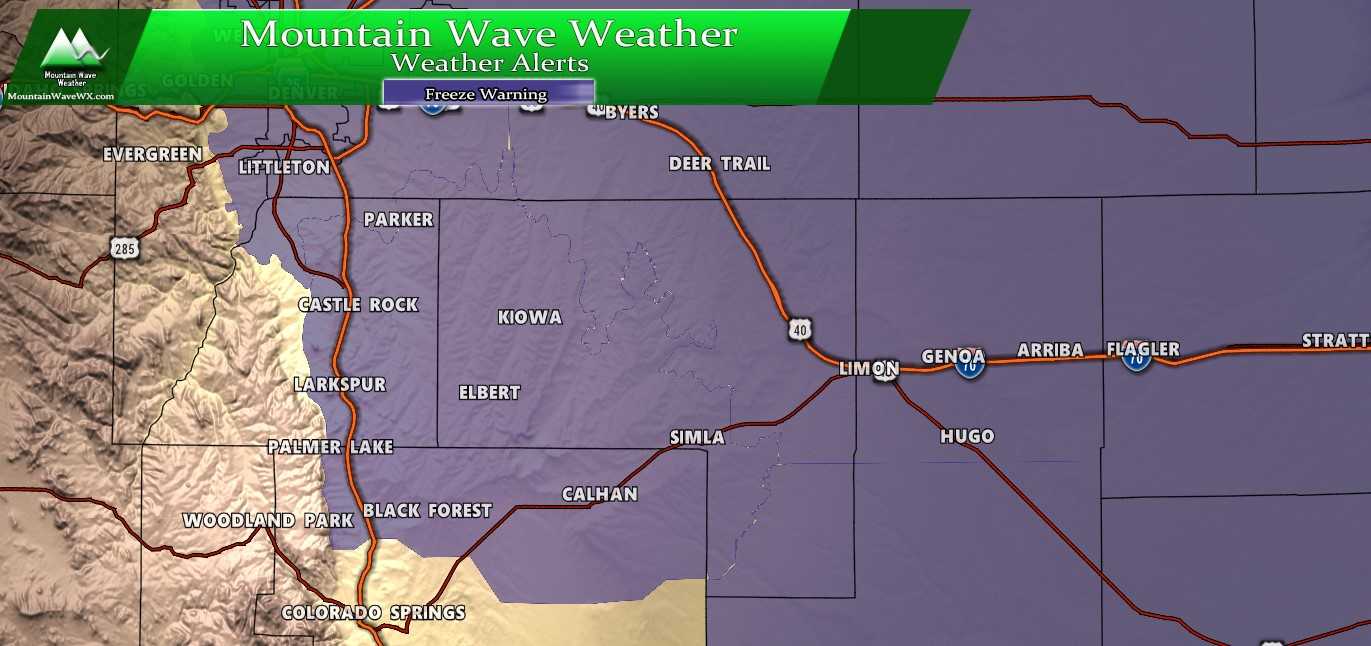
***Freeze Warning***
Including the cities of Fort Collins, Hereford, Loveland, Nunn,
Arvada, Boulder, Golden, Lakewood, Longmont, Aurora, Brighton,
City of Denver, Denver International Airport, Highlands Ranch,
Littleton, Parker, Castle Rock, Elbert, Fondis, Kiowa, Larkspur,
Bennett, Byers, Deer Trail, Leader, Agate, Hugo, Limon, Matheson,
Forder, Karval, Kutch, Punkin Center, Akron, Cope, Last Chance,
and Otis
418 AM MDT Wed Oct 9 2019

...FREEZE WARNING IN EFFECT FROM 10 PM THIS EVENING TO 9 AM MDT
THURSDAY...

* WHAT...Sub-freezing temperatures as low as 20 expected.

* WHERE...Northeast and East Central Colorado, including the
  Denver Metro area.

* WHEN...Freezing temperatures as early as 10 PM Wednesday.

* IMPACTS...Frost and freeze conditions will kill crops, other
  sensitive vegetation and damage unprotected outdoor plumbing.

PRECAUTIONARY/PREPAREDNESS ACTIONS...

Take steps now to protect tender plants from the cold. To prevent
freezing and possible bursting of outdoor water pipes they should
be wrapped, drained, or allowed to drip slowly. Those that have
in-ground sprinkler systems should drain them and cover above-
ground pipes to protect them from freezing.
Around the State
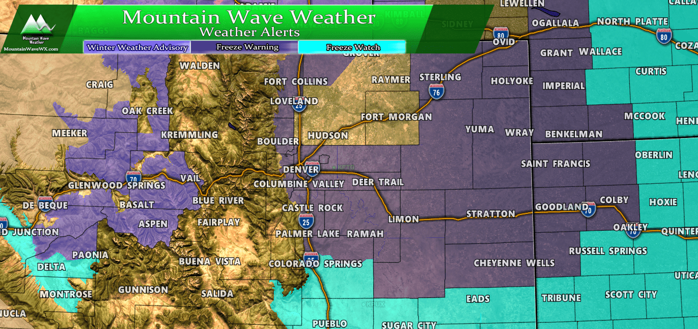
Keep in mind if you are travelling or have outdoor plans. There are several snow/travel/temperature related warnings and advisories out. Many areas in the mountains have Winter Weather Advisories for tough travel conditions. Several plains locations have Freeze Watches or Freeze Warnings out.
Forecast/Hazards/Timelines/Impacts (The Need to Know Planning Stuff!)
Impacts
- Extreme cold
- Wind chill temperatures in the single digits are pretty much a certainty. Air temperatures will be in the low to mid teens across most of the Palmer Divide. New model data shows many areas across the Palmer Divide will see wind chills near zero.
- Prepare any outdoor plumbing, drain above ground sprinklers. If you can’t drain them be sure to cover with blankets. The ground will still be relatively warm so it’s not imperative that sprinkler systems be blow out just yet. Ensure host faucets are disconnected.
- Snowfall/Travel Impacts
- Likely there will be some impacts to Thursday commute. Be prepared for extra time for travelling on Thursday. There’s a potential for an impact on Thursday evening’s commute if snow falls a bit longer and roads remain icy. Expect travel to take a bit longer around the Palmer Divide and Denver Metro area on Thursday in general.
- FLASH FREEZE! – Super concerned that initially warm roads will flash freeze with the moisture and cold air moving in. These events can cause the road to ice over in a matter of minutes. Be super cautious on Thursday!
Timing
- Wednesday
- Will be warm during the day. Windy conditions, high temperatures and low dewpoints will mean fire conditions will be high.
- Models currently have the cold front moving through sometime between 6-10PM. Expect strong winds and rapidly dropping temperatures when that happens.
- Thursday
- Thursday morning commute most likely to be impacted but evening commute could be impacted.
- Snowfall looks most likely on Thursday morning into early Thursday afternoon. Models still disagree on the overall timing but we will keep an eye on it.
- Friday
- Ice and snow may still be possible into Friday morning.
- Travel impacts may linger for the Friday morning commute.
Snowfall
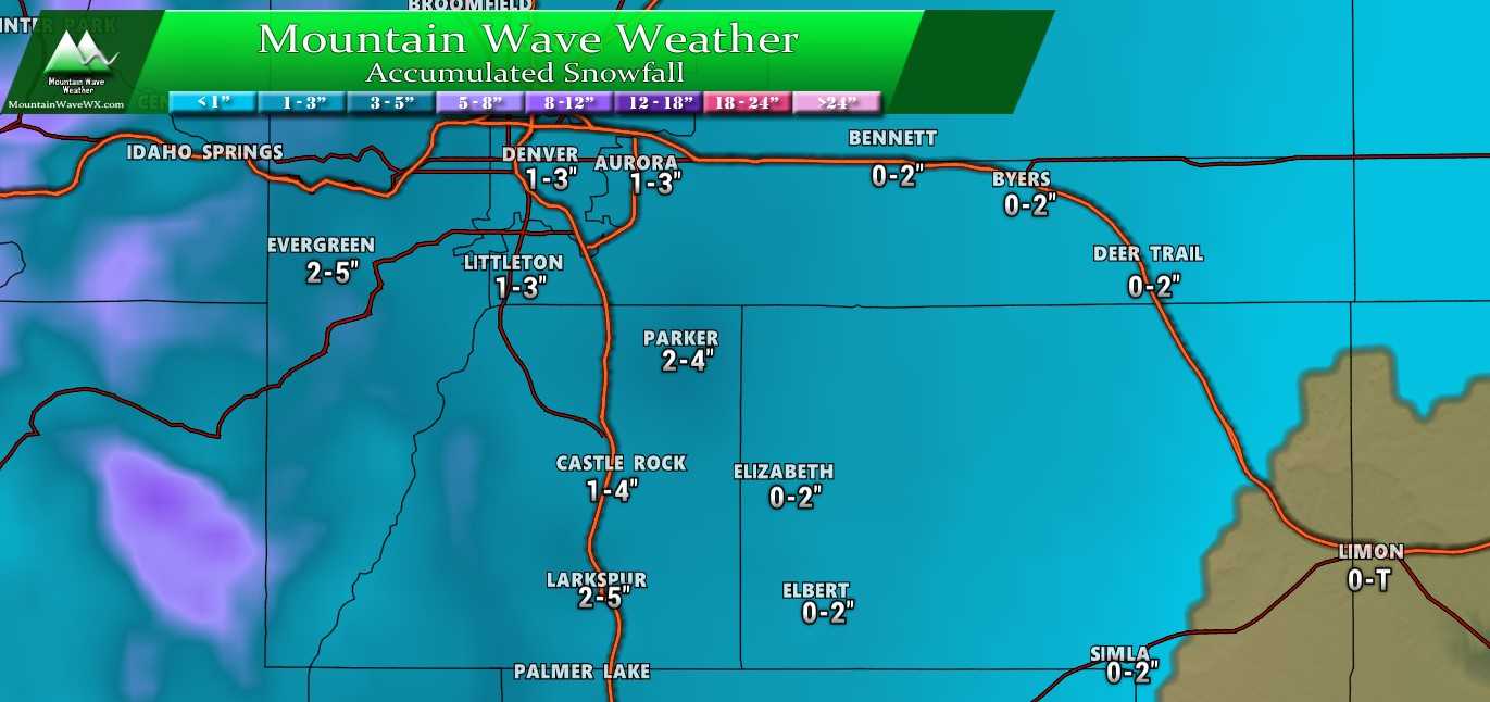
Our original snowfall forecast range. This hasn’t changed since we first posted it.
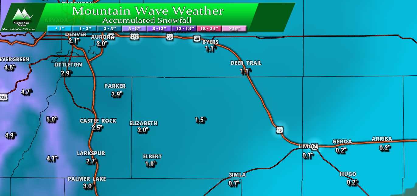
Pinpoint snow totals, no changes here either. Note that most of these areas end up on the lower range or in the middle of our forecast range.
Analysis (The Weather Nerd Stuff)
Snowfall amounts have decreased slightly with nearly all models but are still within our original range so we won’t make a whole lot of changes to our forecast except to say that most areas will see on the lower side of what snowfall ranges we’ve predicted.
Lets’ take a look at some models!
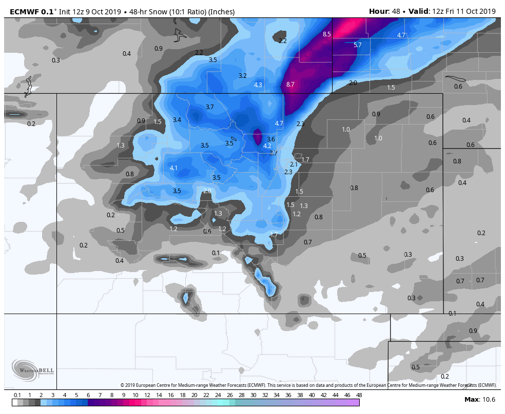
Euro
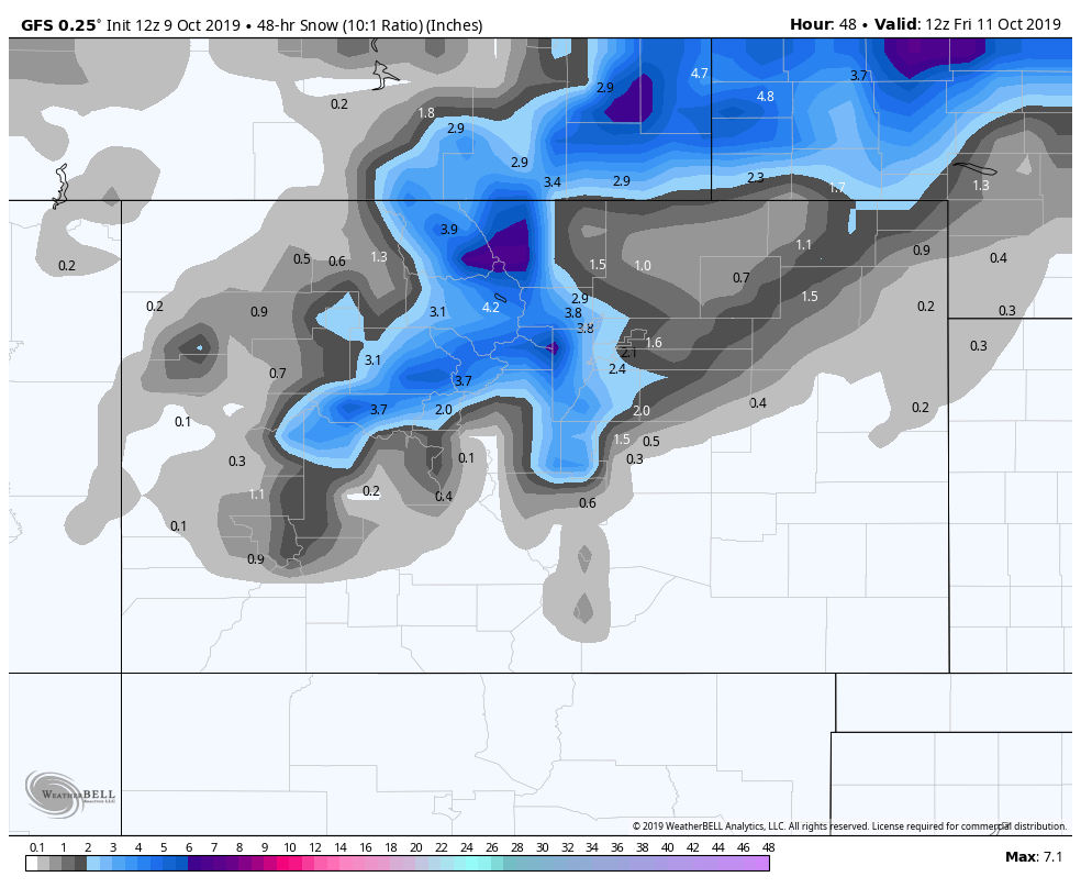
GFS
 Canadian (GEM)
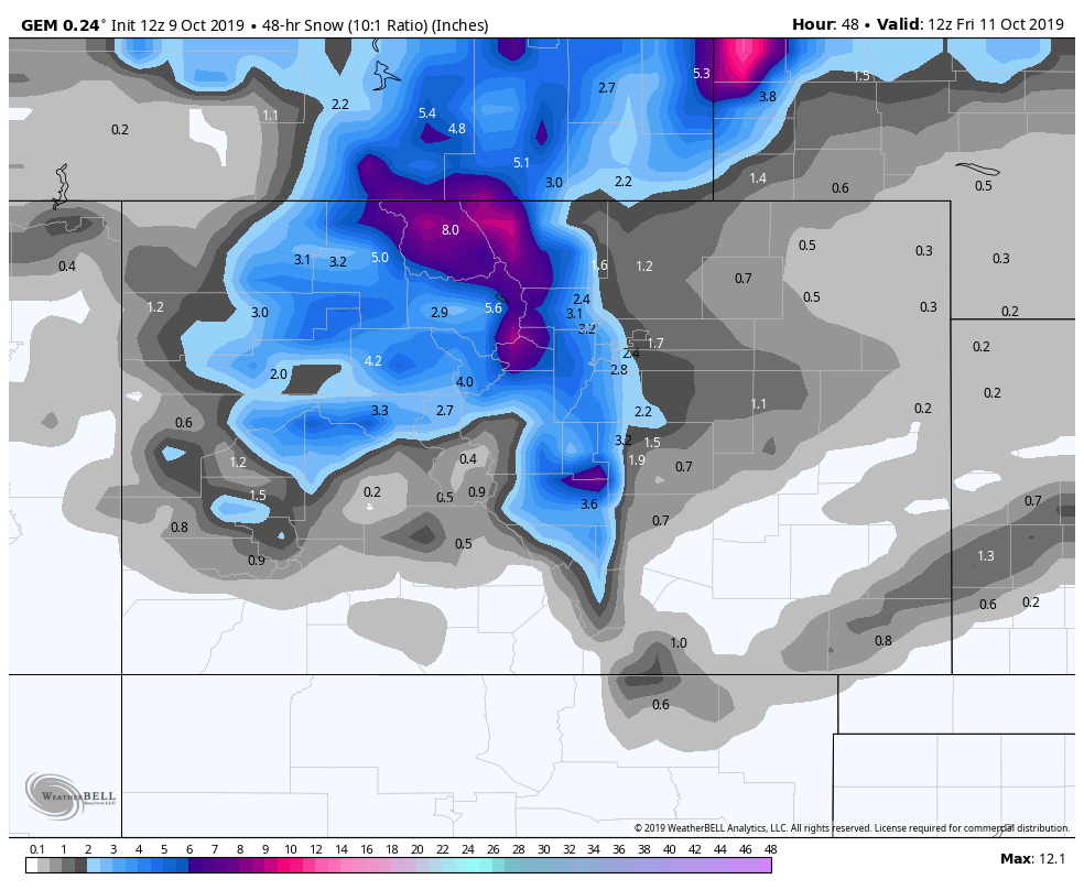 Why do we still look at low res/long range models? They are still useful for watching for patterns and don’t forget that just like all weather models their accuracy is notably higher in these shorter timeframes. We see a great deal of consistency between the models in terms of snowfall amounts for the plains, front range and Palmer Divide. The discrepancy still exists in the mountains, so while that’s normally worth watching… The only model showing significantly higher amounts in the mountains is the Canadian and based on what I know of that model’s behavior with this storm, I’m not going to pay it too much attention.
Luckily for us the higher resolution and regular more running NAM 3K is now in range. This model runs every 3 hours or so and is great at picking up finer details in a storm system, but remember it is still subject to the same rules and biases as the longer range, lower resolution models.
As you look at this Nam3K image you can see it’s pretty in line with the other models as to snowfall amounts but what else do you notice?
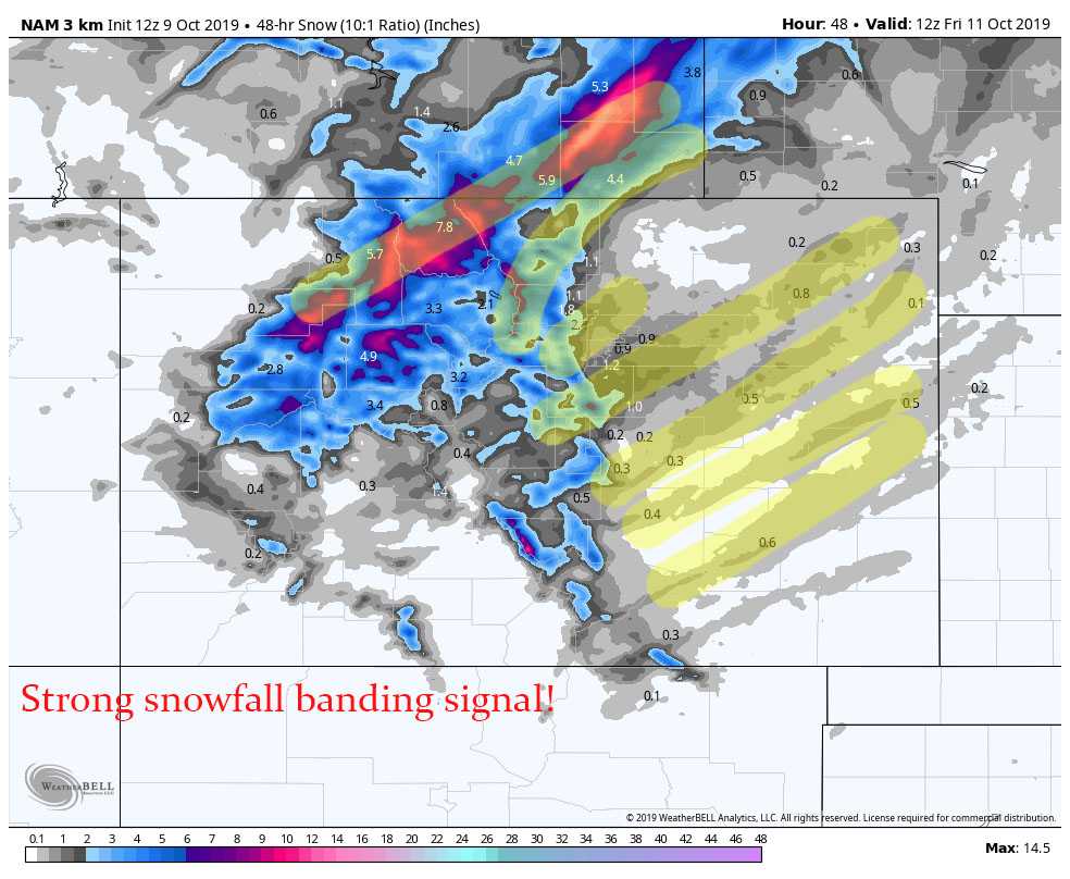
I’ve highlighted in subtle yellow the snowfall bands this model is picking up on. A few things to remember about snowfall bands (AKA jet induced snowfall bands)
- Models such as the Nam3K can tell you whether these are likely or not
- They cannot tell where they will form
- They cannot tell how strong they will be
- They cannot tell how quickly they move or whether they stall over an area.
Banded snowfall means that some very specific areas could “bust high” on snowfall. This means your exact location could see higher snowfall (2-5 inches) and a mile away could see almost nothing. Snowfall bands are incredibly tricky and mean usually a forecast will hold for 90% of the people in your area… but 10% may get dumped on.
I don’t see any evidence of a huge snowfall event for any areas right now based on how warm the ground will be and how moisture starved storms like this usually are. Still some areas may see an hour or two of very intense snowfall under those bands so keep that in mind!
The cold front will move through Wednesday evening…
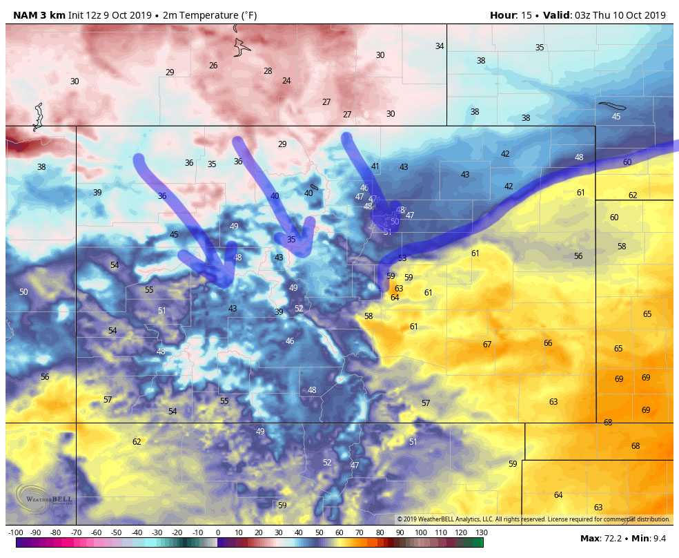
Let’s talk about temperatures real quick, because that is the feature that will make this storm historic. We’ll use data from the Nam3K…
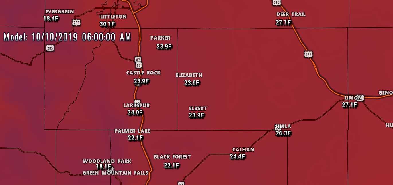
Thursday 6AM low temperatures
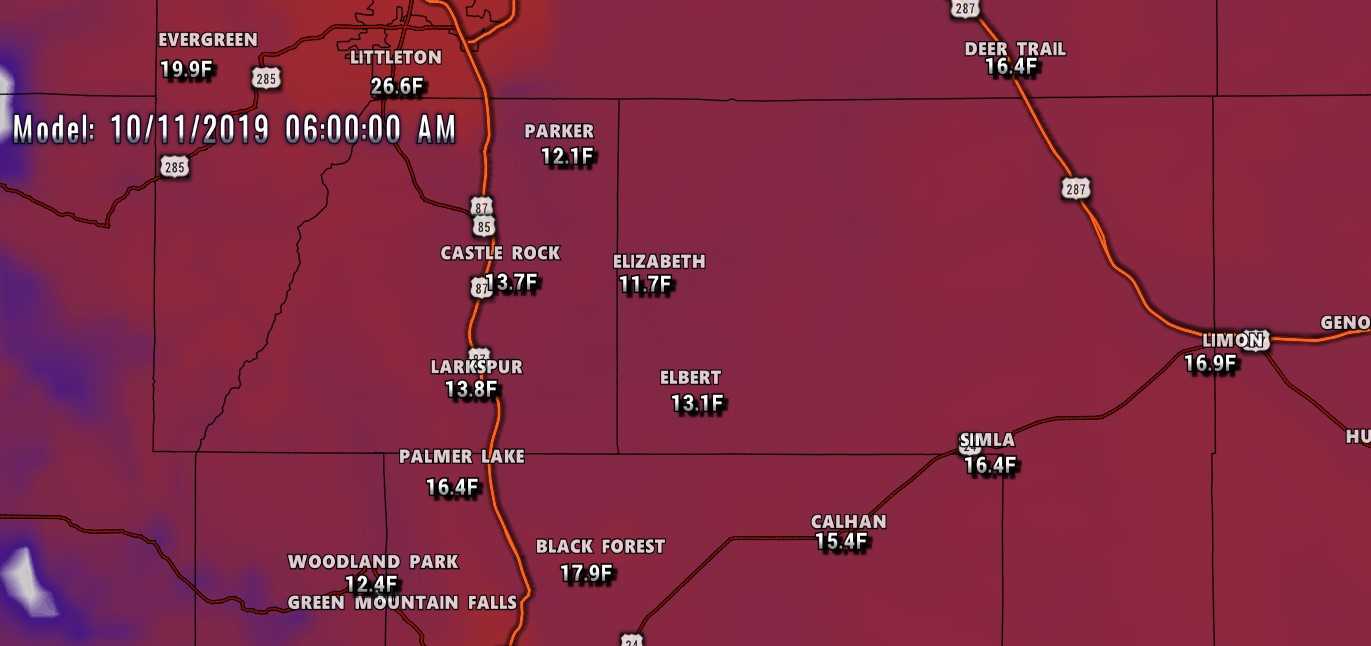
6AM Friday low temperatures
Keep in mind, for a lot of our area record low territory is around 15 degrees. We look like we will either tie or break that pretty handily. Here’s where it gets a bit more interesting… let’s look at apparent temperatures (wind chill or what it will feel like on your skin)
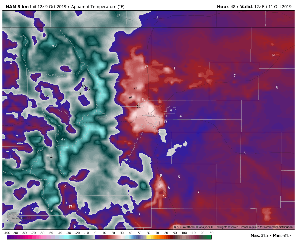
This is the run for 6AM Friday. Note that any of the white areas along the Palmer Divide are wind chill values at or below zero. This is historic for this time of year!
Summary
So our forecast is still largely on track. If you’re getting excited about snow, cool! But it won’t be a big storm as far as snow is concerned. Like we discussed the frigid temperatures will really be the main story of this storm system.
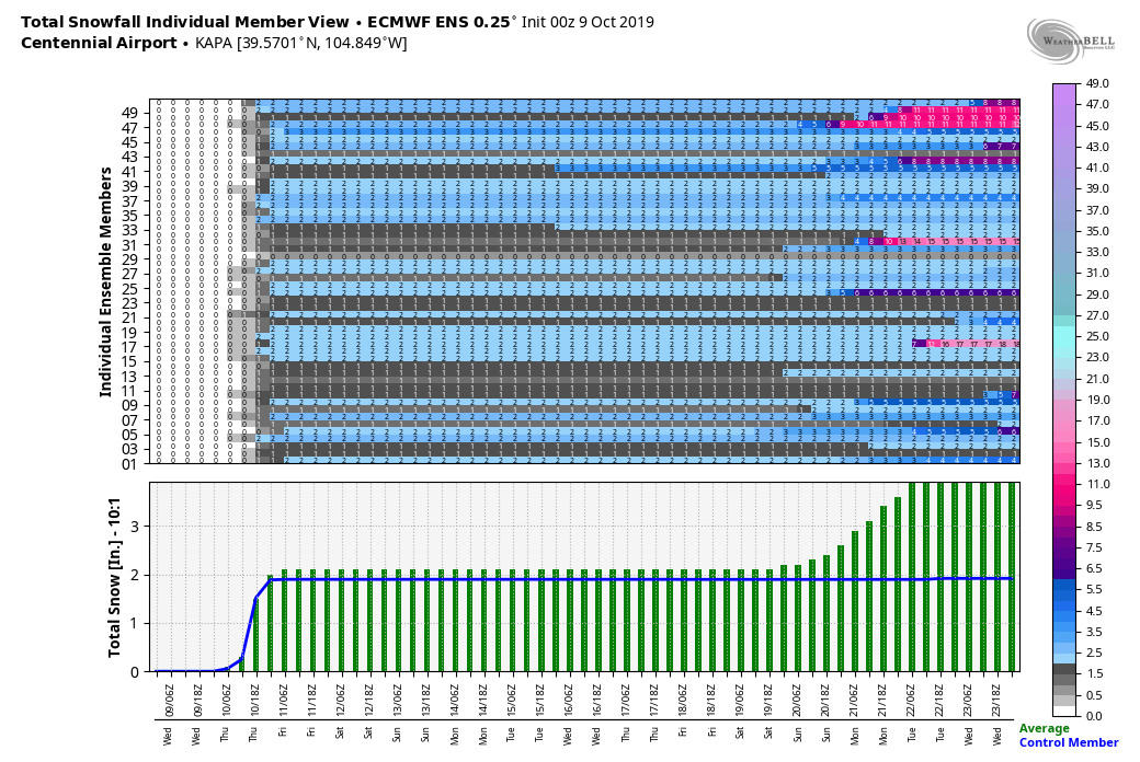
The Euro ensembles seem to be in the ballpark of our snowfall forecast as well, always good to see.
Anyways, make sure everything is prepared for the cold by this evening. We will post any more storm updates as needed so be sure to keep an eye out for those!

