Dusting off the Snow Graphics!
For the first time this year it looks like I get to fire up the snowfall forecast graphics as we finally have a decent chance of accumulating snow for some of our mountain areas. A storm system swinging through this week will usher in cooler air (so it will finally feel a bit like fall) and a decent amount of precipitation especially for the mountains.
Due to warm atmosphere and ground conditions, I don’t see a major accumulation event for anyone really… but some isolated mountain locations could see a total of 2-5 inches of snow accumulation with this storm. I suspect any areas that see accumulation in that range will be above 10,000 feet, but don’t be surprised to see some of the valleys pick up a quick inch or two as well!
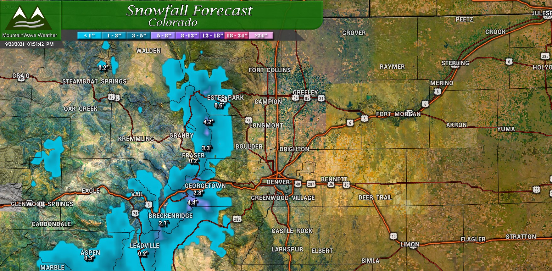
Fire up the 2021-2022 snowfall graphics! Snow is on the way to Colorado mountains this week!
Closer to home… we won’t see snow accumulation along the front range or Palmer Divide. There is a chance we see a bit of moisture out of this, but probably not as much as our mountain locations to the West.
Moisture for the Front Range?
Depending on where you’re located you may see a decent amount of moisture out of this storm system… or not a whole lot at all.
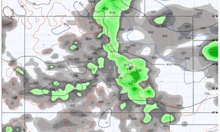
I’ve attached the National Blend of Models product below… remember it’s a model so don’t focus on hard numbers on locations – but look at the overall pattern of areas projected to see more moisture and those with less moisture.
The overarching theme here is that the mountains stand to do fairly well in terms of overall moisture this week while areas South of the Palmer Divide should do well also. Unfortunately, with the more Southern track of this storm, downsloping off the Palmer Divide and into Northeastern Colorado will be a concern. This means those areas will overall be dryer than the other areas I mentioned above.
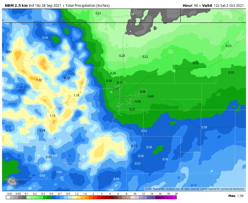
National Blend of Models predicted precipitation through Saturday 6AM
Long story short, if you are along the Palmer Divide North of about Monument into Denver and points North and East – while the temperatures will certainly be cooler… I wouldn’t get too excited about a ton of rain out of this storm just yet.
Cooler Temperatures Are a Lock!
One thing that is looking all but certain for most of Colorado is the noticeable cooldown in temperatures. Here is the Euro ensembles thoughts on the temperatures in the days ahead:
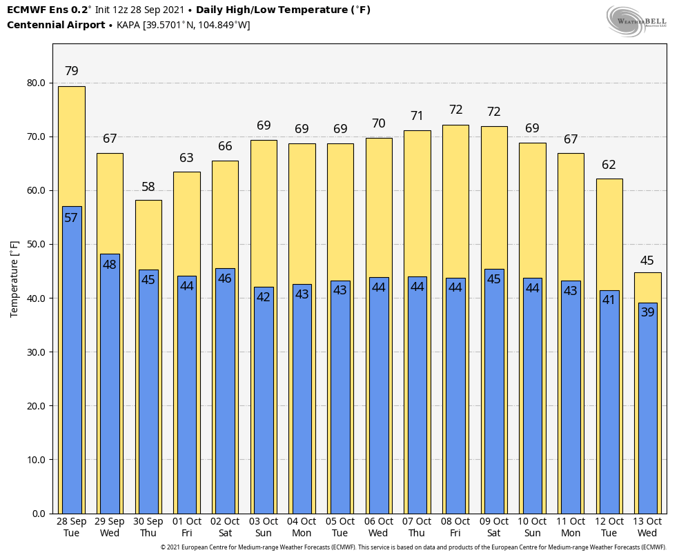
I expect yesterday to be the last “hot” day we will see for some time. Fall looks to take hold as temperatures cool into the 60’s and even 50’s especially on Thursday along the Palmer Divide and urban corridor. While the storm’s positioning is not ideal for a large amount of moisture, it is in a good spot to pull a decent amount of cooler air down from Canada to help cool conditions off a bit!
Timing/Impacts
For the Palmer Divide, our best shot at precipitation comes between 6PM Wednesday night and 6AM Thursday morning. We should be able to tighten that time-frame up a bit with a bit more data, but for now that looks like the prime time. Temperatures will be too warm for any snow so don’t expect to see any flakes flying around.
Point of Emphasis: WE DO NOT EXPECT SNOWFALL ALONG THE PALMER DIVIDE WITH THIS STORM
Your main impacts will just have to do with some wet roads, cooler temperatures and maybe a bit of gusty winds here and there. We don’t expect any travel impacts in the lower elevations.
For the mountains, snow will start Tuesday night and into Wednesday. Some higher mountain passes may see slick roads here and there, but again… not a major impact with this storm.
Summary
Now, since some of you probably didn’t pay attention… go back and look at the temperature forecast above again.
See Wednesday October 13? We’ll be keeping a close eye on that date as SOME models (not all) show the CHANCE of our first accumulating snowfall in the Palmer Divide area somewhere around that time. Remember a model this far out is not to be trusted on finer details (temperatures, snowfall, precipitation amounts) but can serve as a heads up about a potential storm system during that time that needs to be watched.
In terms of this storm and the weather going into the weekend – stay tuned here and we will pass along any updates as needed!
