The latest data is coming in this evening and is making this storm look relatively impressive. We had an idea that it would be an unusual storm (we don’t often seen Northwest Pacific storms produce higher amounts of snow along the front range) but so far models have been very insistent on this one behaving differently.
The Latest from the NWS
Across the board the National Weather Service forecast has been increasing snowfall amounts. I chalk this up to the consistency the models are beginning to show, originally they were lowering totals or showing drastically different amounts but most are now upping snowfall amounts slightly or beginning to agree with higher snow amount model solutions.
Here is the updated probablistic snowfall forecast for some areas around Douglas County:
| For cities in Douglas, CO county |
| Location | At least | Likely | Potential for | 0″ | 0.1-1″ | 1-2″ | 2-4″ | 4-6″ | 6-8″ | 8-12″ | 12-18″ | >18″ |
|---|---|---|---|---|---|---|---|---|---|---|---|---|
| Castle Rock, CO | 3 | 7 | 12 | 2% | 1% | 3% | 12% | 18% | 21% | 30% | 12% | 1% |
| Deckers, CO | 2 | 5 | 10 | 3% | 4% | 6% | 19% | 23% | 20% | 20% | 5% | 0% |
| Franktown, CO | 2 | 5 | 11 | 3% | 2% | 4% | 16% | 22% | 20% | 25% | 8% | 0% |
| Highlands Ranch, CO | 3 | 6 | 11 | 2% | 1% | 4% | 13% | 21% | 22% | 28% | 9% | 0% |
| Larkspur, CO | 1 | 6 | 12 | 7% | 3% | 5% | 13% | 16% | 16% | 25% | 13% | 2% |
| Monument Hill, CO | 2 | 8 | 14 | 8% | 2% | 4% | 10% | 14% | 14% | 26% | 19% | 3% |
| Parker, CO | 3 | 6 | 12 | 1% | 2% | 3% | 12% | 18% | 20% | 29% | 14% | 1% |
| Roxborough Park, CO | 3 | 6 | 14 | 2% | 1% | 3% | 9% | 15% | 16% | 27% | 21% | 6% |
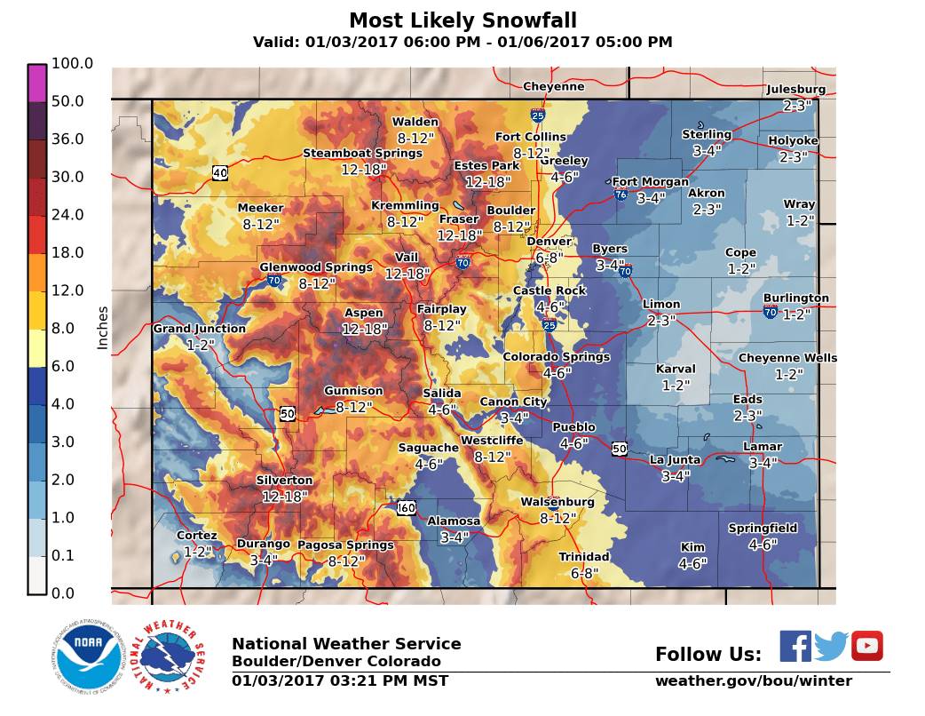
You can see the NWS has pegged the most likely range between 4-6 inches but with a high likely-hood that some areas finish with up to 1 foot. Reaching that number will be very unlikely for most places but we can’t rule out the possibility of SOME very LOCALIZED areas seeing something in that amount.
Our Updated Forecast for the Castle Rock Area
Timing
- The storm is still mainly on track to affect the Castle Rock area late Wednesday night, into the day Thursday and possibly into the late evening or early morning hours of Friday. Some models have shown snow lingering a bit later than expected and any areas under the snow bands could see decent snow totals by the time exits the area.
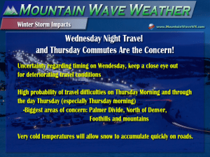
- This has not changed: Expect snow to begin late Wednesday night or early Thursday morning. I’d keep a close eye on that Thursday morning and possibly Thursday evening commute for tough travel conditions. I’m also seeing a bit of concern about the possibility of Wednesday’s snow kicking off a bit early, if so we will need to monitor the Wednesday evenign commute.
Snowfall
- This is going to be a very tough storm to predict snow for, mainly because where the snow bands set up will dictate who gets a ton of snow and who doesn’t. Try not to focus too much on the snow range but more on the impacts the snow and cold will bring.
- 5-10 inches is the range most likely in Castle Rock at this time. I cannot see enough supporting data to confidently say a foot like the NWS says is possible. I do believe snow amounts will be highly variable depending on where you live (I’ve seen some areas in Castle Rock show 8 inches while areas only a few miles away see 4 inches…) Some areas in Southwestern Douglas County could see totals closer to the 7-14 inch range.
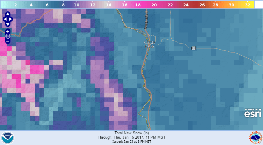
Areas West of Perry Park and Palmer Lake need to be on the lookout for significantly higher snow totals.
Impacts
- The cold air has already arrived from the arctic front to our North. An additional shot of cold air will come late int he day Wednesday so expect very cold temperatures. It will remain cold through at least Friday so expect any snow that falls to stick rather quickly
- Travel conditions look to deteriorate later in the day Wednesday though the exact timing is still a bit in question. We are not sure if the snow will arrive early enough to make Wednesday evening’s commute slick but we are pretty confident travel will be difficult on Thursday morning and possibly throughout most of the day on Thursday.
- Stay tuned through the day Wednesday and we will update ASAP if we see something coming that may affect travel Wednesday evening.
Summary and My Thoughts
This storm has been one of the more difficult I’ve had to predict in awhile. Mainly because these types of storms don’t produce a lot of snow but the models are screaming that this storm will produce decent accumulation. Again, no indication that this will be a “blizzard” type, prolonged storm that will shut the city down for a long period of time. That being said, I do see tough travel conditions later on Wednesday and through a good chunk of the day Thursday.
There is still some uncertainty on the models in terms of snowfall, mainly where those bands will set up and who gets how much. I’m quite confident the Castle Rock area will see snowfall out of this and even a decent amount. Where I’ve still got reservations is if we hit in that 5-10 inch rage, or I should have stayed more with the 3-6 inch range… or should I have upped it to 6-12. I’m hoping to narrow it down on Wednesday as we get into the range of the better resolution and more accurate short term models.
Expect several posts on Wednesday regarding this storm as I imagine we will have a lot of good data coming in. Stay tuned!

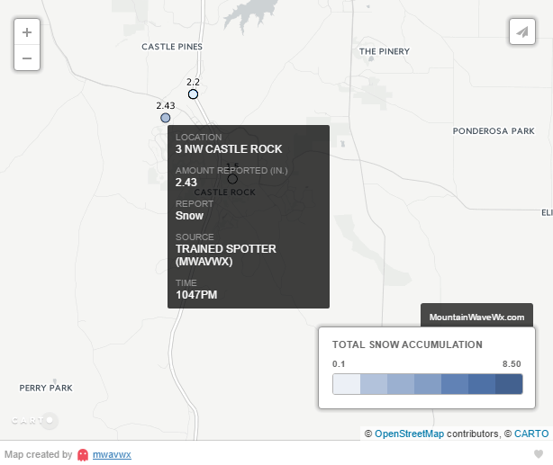

Curious to see how The Meadows fair!
Hoping we still hit that 5-10 inch range but it’s starting to look like we may see less. We need those heavier snow bands to move South from Denver! Fingers crossed!