A strong system is beginning to impact the Western United States this week with a combination of moisture from the pacific and cold air from the arctic regions of North America. The jet stream is set up in a “zonal” West to East flow across the Pacific, into California, across the Great Basin and into Colorado and Wyoming.
Strong “Atmospheric River” across the Pacific into California
Setups like this usually don’t give us much to worry about along the front range of Colorado as we don’t often see strong storms materialize and make it over our mountains. The mountains of Colorado however, usually get hammered so I expect some great power days this week for our ski resorts.
A Few Things About This Storm To Keep An Eye On
As I said above, we usually don’t fret too much about these types of storms in Denver but based on modeling data that has come in last night there are a couple of ingredients coming together with this storm we may need to keep a close eye on.
- There is a ton of moisture
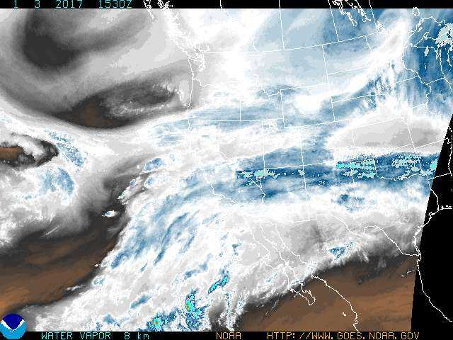
- This storm system is very large and you can see from the image below, it is picking up a lot of moisture as it swings across the Pacific. This moisture will be transported into California and deposit ample amounts of snow for their mountains. Additionally, remaining moisture will make it to Colorado dumping decent amounts of snow in our mountains. The trick here is that some of this moisture may make it over our mountains along the front range because of the next feature we are watching…

- This storm system is very large and you can see from the image below, it is picking up a lot of moisture as it swings across the Pacific. This moisture will be transported into California and deposit ample amounts of snow for their mountains. Additionally, remaining moisture will make it to Colorado dumping decent amounts of snow in our mountains. The trick here is that some of this moisture may make it over our mountains along the front range because of the next feature we are watching…
- Strong Jet Stream
- If you recall our last snowstorm that “overperformed” here I mentioned several times about the jet stream overhead. The jet helps to enhance upslope snowfall that may form along the front range. The catch here is that it does so only under bands of snowfall that set up. Any areas under those bands of snow will see higher snow totals while areas only 10-20 miles away could see little to nothing. The jet will be over Colorado again with this storm so I expect to see a very similar setup and the jet stream will actually be slightly stronger this time around.

- Timing Combination on Cold Front and Jet Stream Setup/ Snow Banding
- When we get setups like this we often see a combination of jet enhanced upslope and a strong cold front combine to make for short, but intense bursts of snow. This can often catch people off gaurd as it can began snowing very heavily very quickly and roads can become slick in a matter of an hour or so. Snow banding is very evident on the models that I am seeing this morning so I don’t doubt we will see that set up. The key thing to remember here is that models are terrible at predicting where snow bands set up.
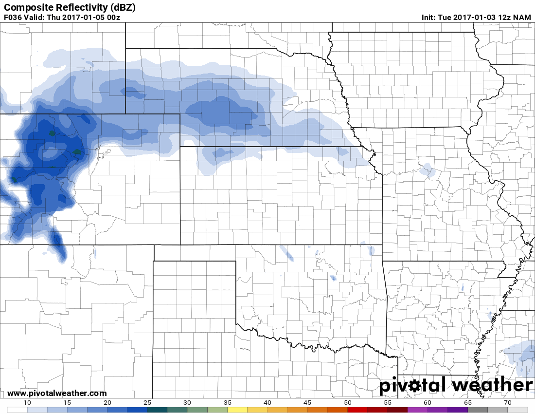
Wednesday night the NAM shows a strong snow band North of Denver

Late Weds into Thurs, the NAM shows the snow band slowly migrating South
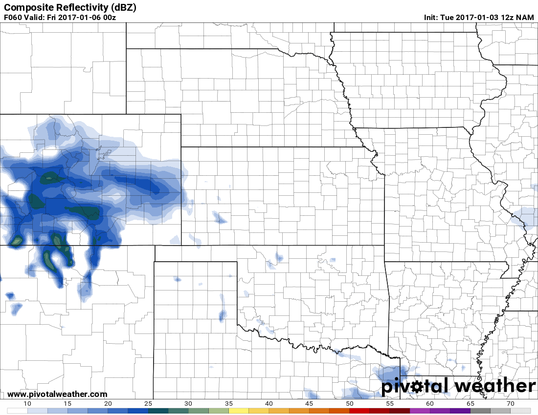
By Early Thurs, snow band is shown setting up over the Palmer Divide
My concern for the Castle Rock area is that last picture. Should that particular model snapshot verify and assuming the band sits over us for a decent amount of time, we could see decent snow totals in our area. This is something I’ll keep a close eye on over the next 48 hours…
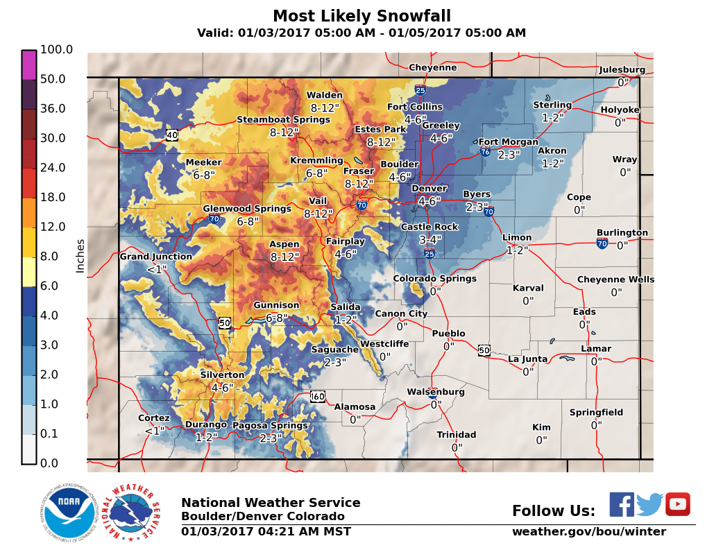
Our Official *Preliminary* Forecast
I do expect these final numbers to change a bit as there is still considerable uncertainty on the forecast overall. The National Weather Service has their probabilistic snowfall forecast up and fits quite nicely to what I’m thinking the Castle Rock area will see out of this storm at this point in time.
| For cities in Douglas, CO county |
| Location | At least | Likely | Potential for | 0″ | 0.1-1″ | 1-2″ | 2-4″ | 4-6″ | 6-8″ | 8-12″ | 12-18″ | >18″ |
|---|---|---|---|---|---|---|---|---|---|---|---|---|
| Castle Rock, CO | <1 | 3 | 6 | 7% | 7% | 12% | 31% | 26% | 13% | 4% | 0% | 0% |
| Deckers, CO | <1 | 1 | 5 | 6% | 14% | 21% | 35% | 17% | 6% | 1% | 0% | 0% |
| Franktown, CO | <1 | 3 | 6 | 6% | 8% | 13% | 34% | 26% | 10% | 3% | 0% | 0% |
| Highlands Ranch, CO | 1 | 4 | 7 | 4% | 6% | 10% | 30% | 28% | 16% | 6% | 0% | 0% |
| Larkspur, CO | <1 | 2 | 6 | 9% | 10% | 14% | 29% | 22% | 11% | 5% | 0% | 0% |
| Monument Hill, CO | <1 | 3 | 7 | 11% | 8% | 11% | 27% | 22% | 14% | 7% | 0% | 0% |
| Parker, CO | 1 | 4 | 7 | 6% | 5% | 10% | 28% | 25% | 17% | 9% | 0% | 0% |
| Roxborough Park, CO | 1 | 3 | 8 | 4% | 5% | 9% | 25% | 23% | 16% | 15% | 3% | 0% |
NWS Denver/Boulder Probablistic Snowfall Range Chart
Timing
- This storm’s impact will slightly prolonged but we are not expecting a major storm lasting several days; the first affects will be felt late Wednesday night and into Thursday. An additional shot of cold air and snow may occur later in the day Thursday so we’ll keep an eye on that.
- Expect snow to begin late Wednesday night or early Thursday morning. I’d keep a close eye on that Thursday morning and possibly Thursday evening commute for tough travel conditions.
Snowfall
- There is still a bit of uncertainty on overall snowfall amounts, especially in respect to where the bands set up (which will make a huge difference.) However I feel pretty confident saying that Castle Rock will see at least some snow.
- 3-6 inches is the range most likely in Castle Rock at this time. This number may change slightly with more data in over the next few hours so I’ll keep an eye on it and pass along any changes. Some areas in Southwestern Douglas County could see totals closer to the 4-8 inch range.
- ***Please Note: Due to the unpredictability of how jet-induced snow bands behave, this number could be slightly higher or lower depending on the set up***
Impacts
- The cold air has already arrived from the arctic front to our North. An additional shot of cold air will come late int he day Wednesday so expect very cold temperatures. It will remain cold through at least Friday so expect any snow that falls to stick rather quickly
- Keep a close eye out for tough travel conditions especially Thursday morning with additional travel difficulties through the day Thursday in certain areas depending on where the heavier snow bands linger.
Summary
This storm looks to bring some travel and temperature impacts but this is not the type of storm that stalls over the front range and produces feet of snow. Despite the hype that has been going around with this storm system I will say this; This storm does not warrant a trip to the store to load up on break and milk. The only travel difficulties will be during Thursday, by Friday we will have clearing and better travel conditions.
The 3-6 inch range looks most likely for snowfall in Castle Rock at this time, but I can see anywhere between 1-3 inches to 5-10 possible depending on whether we get a snow-band to park over us for awhile. So be prepared for that, with the most likely travel impact being Thursday morning.
I’ll keep a close eye on the models coming in and be sure to pass along any changes if the storm looks less impressive or more threatening over the coming hours. Stay tuned!
